John Erwin
EF5
**rescued post**
JFarrer
Joined: 22 Aug 2006
Posts: 31
Location: Crawfordsville, IN
Posted: Fri Aug 25, 2006 9:10 am
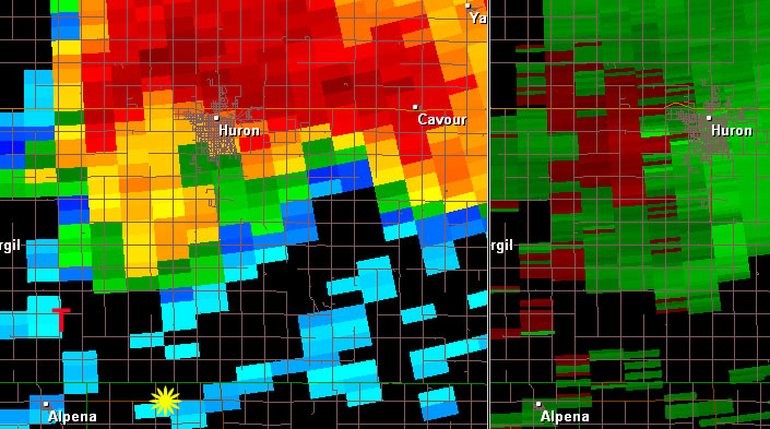
Congrats to everyone who bagged, what a day!! Im curious if anybody has any GRLevel data on these storms?
Scott Olson
Moderator
Joined: 17 Sep 2004
Posts: 1021
Location: Brookings, South Dakota
Posted: Fri Aug 25, 2006 9:27 am
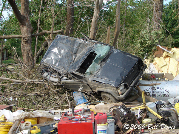
Leaving today at 2pm to go take some damage pictures. Anyone who witnessed the Cavour tornado want to try and estimate a location? Im pretty sure the intial tornado that formed 3 ESE of Wessington traveled all the way to 3-4 S of Huron. I was still on it then and if there was a tornado in Cavour it must have been a new circulation the north. About the same time the Cavour tornado was happening I was witnessing a possible anticyclonic tornado a little further south. I remember the next radar update showing a bit of an anticyclonic flare. Anyway, if you have any areas you think may have taken a hit by any of these tornadoes please pass them on via PM and I will do the best I can to get some pictures.
Thanks,
Scott Olson.
_________________
www.axisofnature.comashleyallen
Joined: 24 Aug 2006
Posts: 3
Location: Madison, SD
Posted: Fri Aug 25, 2006 10:34 am
It was two south or maybe right on top of Cavour. Sheriff's report indicated damage in the town of cavour. I was seven miles south of it when it when through/by Cavour.
Just go into Cavour on Highway 14 and I bet you will find some damage. I believe my friend Kory Hartman is heading there over the lunch hour to take some pictures/video also.
I am editing video right now... should have something up soon.
Jayson Prentice
Joined: 19 Dec 2004
Posts: 325
Location: Terril, IA - Ames, IA
Posted: Fri Aug 25, 2006 11:07 am
Here is a couple of radar grabs of GRAnalyist on the tornadic storm in MN, Thanks to Mike Gibson.
http://www.grlevelx.com/downloads/kmpx_20060824_2254_tube.png
http://www.grlevelx.com/downloads/kmpx_20060824_2258_tube.png
_________________
Jayson Prentice -- Iowa State University Meteorology '09 -- KCOTQO
Storm Chasing & Iowa Weather <-- New Homepage!
Scott Olson
Moderator
Joined: 17 Sep 2004
Posts: 1021
Location: Brookings, South Dakota
Posted: Fri Aug 25, 2006 11:12 am
ashleyallen wrote: It was two south or maybe right on top of Cavour. Sheriff's report indicated damage in the town of cavour. I was seven miles south of it when it when through/by Cavour.
Just go into Cavour on Highway 14 and I bet you will find some damage. I believe my friend Kory Hartman is heading there over the lunch hour to take some pictures/video also.
I am editing video right now... should have something up soon.
Thanks and it's great to see another SD chaser on here, from Madison no less. It's hard to find my breath looking at the video. Wolsey was absoltute chaos, the tornado was about a mile away and was about 1/4 getting larger. There was a fireman in the road yelling at the people that 'it was right there, last chance!". At the worst moment possible a train went through the middle of the city, I had to pack west (towards the tornado) in order to get safely in front of it. I was going to let CNN use my video but they wouldn't even give me a curtosity web plug but instead offered money (I could care less about money right now). The guy went into a spill about being a 24 hr news network and how they don't like doing curtosity plugs, I stopped listening. I should have told him it was footage of Jon Benet Ramsey or Gary Condit or OJ Simpson. Anyways im going to have it on KDLT (maybe national NBC) later. At times it reminded me of pictures of Spencer with striking resemblance. Which is ironic since Mike H and I had a conversation the night before about some similarities with the Spencer UL features.
Scott.
_________________
www.axisofnature.com
Aaron Kennedy
Joined: 08 Dec 2003
Posts: 1895
Location: Grand Forks, ND
Posted: Fri Aug 25, 2006 11:51 am
We observed the tornado due south of Cavour and perhaps a few miles east/west before it roped out. I think our report to NWS was ~2mi south of Cavour.
Aaron
_________________
Aaron Kennedy
Graduate Student, U. of North Dakota
http://www.ontheplains.com
Scott Olson
Moderator
Joined: 17 Sep 2004
Posts: 1021
Location: Brookings, South Dakota
Posted: Fri Aug 25, 2006 12:18 pm
Quote: Congrats to all that scored - I sadly did not. We teamed up with Eric Whitehill and opted to go after things in MN and were too late. Full report and pictures at http://www.carpetempestas.com

Ed, I did a double take on the picture you posted. Are you sure you didn't score any rope tornadoes?
_________________
www.axisofnature.com
Edward Ballou
Joined: 16 Jun 2004
Posts: 477
Location: Brookings, SD
Posted: Fri Aug 25, 2006 12:23 pm
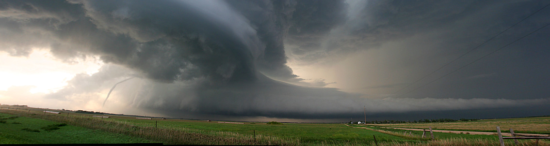
I know, another person emailed me about it. I just can't do enough editing to see if I really got it or not. The reason I say it isn't one is because I had my window rolled up when I took the picture from inside the car. If you edit it enough, I believe you can make out a screw on the right side of the picture. There is some reflection going on.
I have a high res version at home...would anyone be willing to do some photoshopping on it to see if it really was one or not? PM me if you're willing..thanks!
The two (lower-res) pictures I grabbed:

_________________
Seize the Storm ~ http://carpetempestas.com Back to top
Edward Ballou
Joined: 16 Jun 2004
Posts: 477
Location: Brookings, SD
Posted: Fri Aug 25, 2006 3:08 pm
I checked the times, and it was taken at 6:45 pm east of Mankato, roughly between Mankato and Smiths Mill, maybe Janesville. It could have been before Eagle Lake though. The view is looking north.
We turned north when we met road construction and the road east was closed.
_________________
Seize the Storm ~ http://carpetempestas.com
B Ozanne
Joined: 03 May 2004
Posts: 1625
Location: Connecticut
Posted: Fri Aug 25, 2006 3:26 pm
I'm not seeing anything that gives me a definitive answer either way.
Pro: It really looks like a tornado
Con: It doesn't seem to be coming from a tornado producing cloud
It is exactly the same shape in both photos (reflection?)
Hopefully somebody else can help out. For now I'd watch the reports and see if anything pops up in that area.
_________________
Bill Ozanne
Tokeneke Technology Solutions
EasternLight.net
Edward Ballou
Joined: 16 Jun 2004
Posts: 477
Location: Brookings, SD
Posted: Fri Aug 25, 2006 4:29 pm
A trained spotter reported a tornado by Waterville at 6:25. The clock on my camera was behind by an hour, but was right on for the minutes. Like I said already, I took those pictures at 6:45. I don't think I could have caught it 20 minutes later.
I also agree with Bill's point - it doesn't look like that was where a tornado would be. I was always concentrating on the feature to the left. The only way it could be something if there was a cell on the north side.
_________________
Seize the Storm ~ http://carpetempestas.com
JFarrer
Joined: 22 Aug 2006
Posts: 31
Location: Crawfordsville, IN
Posted: Fri Aug 25, 2006 9:10 am
Congrats to everyone who bagged, what a day!! Im curious if anybody has any GRLevel data on these storms?
Scott Olson
Moderator
Joined: 17 Sep 2004
Posts: 1021
Location: Brookings, South Dakota
Posted: Fri Aug 25, 2006 9:27 am
Leaving today at 2pm to go take some damage pictures. Anyone who witnessed the Cavour tornado want to try and estimate a location? Im pretty sure the intial tornado that formed 3 ESE of Wessington traveled all the way to 3-4 S of Huron. I was still on it then and if there was a tornado in Cavour it must have been a new circulation the north. About the same time the Cavour tornado was happening I was witnessing a possible anticyclonic tornado a little further south. I remember the next radar update showing a bit of an anticyclonic flare. Anyway, if you have any areas you think may have taken a hit by any of these tornadoes please pass them on via PM and I will do the best I can to get some pictures.
Thanks,
Scott Olson.
_________________
www.axisofnature.comashleyallen
Joined: 24 Aug 2006
Posts: 3
Location: Madison, SD
Posted: Fri Aug 25, 2006 10:34 am
It was two south or maybe right on top of Cavour. Sheriff's report indicated damage in the town of cavour. I was seven miles south of it when it when through/by Cavour.
Just go into Cavour on Highway 14 and I bet you will find some damage. I believe my friend Kory Hartman is heading there over the lunch hour to take some pictures/video also.
I am editing video right now... should have something up soon.
Jayson Prentice
Joined: 19 Dec 2004
Posts: 325
Location: Terril, IA - Ames, IA
Posted: Fri Aug 25, 2006 11:07 am
Here is a couple of radar grabs of GRAnalyist on the tornadic storm in MN, Thanks to Mike Gibson.
http://www.grlevelx.com/downloads/kmpx_20060824_2254_tube.png
http://www.grlevelx.com/downloads/kmpx_20060824_2258_tube.png
_________________
Jayson Prentice -- Iowa State University Meteorology '09 -- KCOTQO
Storm Chasing & Iowa Weather <-- New Homepage!
Scott Olson
Moderator
Joined: 17 Sep 2004
Posts: 1021
Location: Brookings, South Dakota
Posted: Fri Aug 25, 2006 11:12 am
ashleyallen wrote: It was two south or maybe right on top of Cavour. Sheriff's report indicated damage in the town of cavour. I was seven miles south of it when it when through/by Cavour.
Just go into Cavour on Highway 14 and I bet you will find some damage. I believe my friend Kory Hartman is heading there over the lunch hour to take some pictures/video also.
I am editing video right now... should have something up soon.
Thanks and it's great to see another SD chaser on here, from Madison no less. It's hard to find my breath looking at the video. Wolsey was absoltute chaos, the tornado was about a mile away and was about 1/4 getting larger. There was a fireman in the road yelling at the people that 'it was right there, last chance!". At the worst moment possible a train went through the middle of the city, I had to pack west (towards the tornado) in order to get safely in front of it. I was going to let CNN use my video but they wouldn't even give me a curtosity web plug but instead offered money (I could care less about money right now). The guy went into a spill about being a 24 hr news network and how they don't like doing curtosity plugs, I stopped listening. I should have told him it was footage of Jon Benet Ramsey or Gary Condit or OJ Simpson. Anyways im going to have it on KDLT (maybe national NBC) later. At times it reminded me of pictures of Spencer with striking resemblance. Which is ironic since Mike H and I had a conversation the night before about some similarities with the Spencer UL features.
Scott.
_________________
www.axisofnature.com
Aaron Kennedy
Joined: 08 Dec 2003
Posts: 1895
Location: Grand Forks, ND
Posted: Fri Aug 25, 2006 11:51 am
We observed the tornado due south of Cavour and perhaps a few miles east/west before it roped out. I think our report to NWS was ~2mi south of Cavour.
Aaron
_________________
Aaron Kennedy
Graduate Student, U. of North Dakota
http://www.ontheplains.com
Scott Olson
Moderator
Joined: 17 Sep 2004
Posts: 1021
Location: Brookings, South Dakota
Posted: Fri Aug 25, 2006 12:18 pm
Quote: Congrats to all that scored - I sadly did not. We teamed up with Eric Whitehill and opted to go after things in MN and were too late. Full report and pictures at http://www.carpetempestas.com
Ed, I did a double take on the picture you posted. Are you sure you didn't score any rope tornadoes?
_________________
www.axisofnature.com
Edward Ballou
Joined: 16 Jun 2004
Posts: 477
Location: Brookings, SD
Posted: Fri Aug 25, 2006 12:23 pm
I know, another person emailed me about it. I just can't do enough editing to see if I really got it or not. The reason I say it isn't one is because I had my window rolled up when I took the picture from inside the car. If you edit it enough, I believe you can make out a screw on the right side of the picture. There is some reflection going on.
I have a high res version at home...would anyone be willing to do some photoshopping on it to see if it really was one or not? PM me if you're willing..thanks!
The two (lower-res) pictures I grabbed:
_________________
Seize the Storm ~ http://carpetempestas.com Back to top
Edward Ballou
Joined: 16 Jun 2004
Posts: 477
Location: Brookings, SD
Posted: Fri Aug 25, 2006 3:08 pm
I checked the times, and it was taken at 6:45 pm east of Mankato, roughly between Mankato and Smiths Mill, maybe Janesville. It could have been before Eagle Lake though. The view is looking north.
We turned north when we met road construction and the road east was closed.
_________________
Seize the Storm ~ http://carpetempestas.com
B Ozanne
Joined: 03 May 2004
Posts: 1625
Location: Connecticut
Posted: Fri Aug 25, 2006 3:26 pm
I'm not seeing anything that gives me a definitive answer either way.
Pro: It really looks like a tornado
Con: It doesn't seem to be coming from a tornado producing cloud
It is exactly the same shape in both photos (reflection?)
Hopefully somebody else can help out. For now I'd watch the reports and see if anything pops up in that area.
_________________
Bill Ozanne
Tokeneke Technology Solutions
EasternLight.net
Edward Ballou
Joined: 16 Jun 2004
Posts: 477
Location: Brookings, SD
Posted: Fri Aug 25, 2006 4:29 pm
A trained spotter reported a tornado by Waterville at 6:25. The clock on my camera was behind by an hour, but was right on for the minutes. Like I said already, I took those pictures at 6:45. I don't think I could have caught it 20 minutes later.
I also agree with Bill's point - it doesn't look like that was where a tornado would be. I was always concentrating on the feature to the left. The only way it could be something if there was a cell on the north side.
_________________
Seize the Storm ~ http://carpetempestas.com