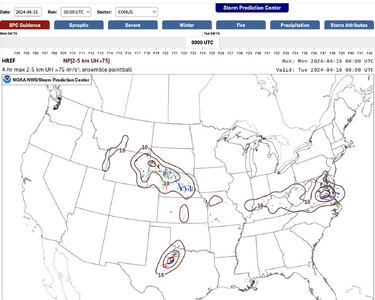
Here is a take based on some less-than-stellar forecasts for this severe season so far. Many forecasters, including ones who are far better than I are sometimes not paying enough attention to one very basic thing: Will there be any storms at all in the area were parameters look otherwise to be great for supercells/tornadoes? Conversely, in the same vein will there be *too many* storms? For an example of the former scenario, we need look no further than yesterday. In the area from SW Kansas to West TX the parameters like the shear/CAPE combo on forecast soundings looked to be pretty optimal for supercells/tornadoes. The rub, however, was there were only a handful of storms, and there were few severe reports and no tornadoes.
My concern all along for yesterday was that for several days, including leading right up to the event, the models, including the now pretty numerous CAMs, were very consistent in showing a rather large zone where no or little convection except for a zone in NW Texas. The attached frames are the 00Z Mon HREF ensemble forecasts for updraft helicity at 00Z Tue. Note the lack of any sort of signal in the KS/OK area. This is one snapshot of one set of models, but this trend was very consistent not just from various models, but it was also consistent over quite a few days before the event,
My general point is that forecasters need to look not just at how good the environment looks from a parameter standpoint, but they also need to examine several runs of various models to see if storms will actually occur, or in the latter scenario above, see if the storms might be so numerous that chasing will be not productive for seeing a photographable tornado or good storm structure.

