doppler radar/PUPS display and wsr-74 question

The radar transmits a brief "pulse" of energy, usually for about 4 millionths of a second. When the radar is in transmit mode, it cannot receive signals. So, if the radar is close to the ground, when the side lobes strike hills, buildings, etc., the radar is still in transmit mode when the reflected signal returns to the antenna so it is "invisible" (i.e., the radar is still transmitting). But, if the radar is high above the ground, the radar has time to return to "receive" mode. So, the side lobes are received and displayed and, because the radar is higher up, the side lobes can strike ground farther away and still come back to the antenna.

As I mentioned in my first post, this is counterintuitive. But, it is important as it is a vital aspect of radar siting.

Exactly, and that's why I laugh at OKC's Mike Morgan (or Rick Mitchell?) when they talk about how their South Doppler is set high upon a hill... Unfortunately, he doesn't know that may actually be better to put the radar in a very gentle valley, since that'll confine the sidelobes that hit the ground to be near the radar... With that radar being a hill, the sidelobes travel larger distances before hitting the ground and creating ground clutter (as Mike said above). Their ground clutter patterns cover a very large area sometimes, which is unfortunate as it can mask true weather returns. It's something I never thought about until we talked about it in radar class...
 
Here's a map of the pre-modernized radar network that I've put together. It's based on other maps and documentation and there could still be errors.


There should be 45 WSR-57s, 13 WSR-74Ss, 66 WSR-74Cs and one WR100-5. This includes the one WSR-74S at San Juan, PR. The 22 ARTC radars were added to the network in 1966. Several WSR-57s were replaced by 74Ss in the early 80s, including Marseilles, IL, Washington, DC (was at IAD, 74S was installed at Patuxent River NAS), Key West, FL, Memphis, TN. Three WSR-74s were equipped with a Doppler add-on by EEC. Those were at Montgomery and Huntsville, AL and at Marseilles, IL. As Mike Smith mentioned, some 74Ss were used as local warning radars (such as Jackson, KY). That WR100-5 in Victoria, TX was manufactured by EEC in the early 70s (before the 74 series).

The first WSR-57 to be installed was at the Miami Hurricane Center in 1959 and the last was at Hondo, TX in 1971. I think the first WSR-74C was installed at Corpus Christi, TX on 2/1/76. There is still at least one 74C that has not been decommissioned and is located at Williston, ND.


The orignal 31 WSR-57s were installed starting in 1959 through the early 60s at existing Weather Bureau offices. Here's a map of the original 31


According to Whiton ET AL.
Forteen of these were placed along the Atlantic and Gulf coasts to aid in hurricane tracking. Some are located inland of the coat to track decaying tropical systems and heavy rains. As mentioned earlier, some were placed in the central part of the country for severe storm tracking. Two were installed in the mountains of the west. The Sacramento radar was put there to support state and federal hydrological efforts and at Point Six Mountain (near Missoula, MT) to locate areas where lightning could create wildfires. The WSR-57 at Medford was installed in 1971 with the second batch of -57s. The radar at Catalina Island (atop Blackjack Mountain) was only in operation for part of the 60s.

The U.S. Navy bought eight WSR-57s and renamed the units according to their military nomenclature: AN/FPS-41.

Forteen additional WSR-57s were purchased and installed from 1967-1971.

Early WSR series
These were APS-2F aircraft detection radars converted for meteorological uses. At the height of the program in 1975, there was 82 WSR-1, 1a, 3 and 4 radars in service in the NWS. These were all replaced by the WSR-74C line from 1976 to 1980. There was also a Decca-41 radar at Akron, Ohio. These early WSRs are pretty similar, but their consoles and electronics differ somewhat. These early radars all had a 10.5 cm wavelength, peak power output of 50 kw, a beamwidth of 4 degrees and a pulse duration of 1 microsecond in short pulse mode and 2 microseconds in long pulse (except the WSR-4, which was 4 microseconds).

First Weather Radar
The first radar to be built specifically for meteorological purposes was the AN/CPS-9, built for the Air Weather Service and began installations in 1953. The CPS-9 was an X-band system, had a 1 degree beamwidth, a 5 microsecond long pulse mode and 0.5 microsecond short pulse mode. Distance on the PPI and RHI scopes were measured in statute miles (instead of nautical miles).

There's an excellent paper on the pre-nexrad era from Weather and Forecasting called "History of Operational Use of Weather Radar by U.S. Weather Services. Part I: The Pre-Nexrad Era". It's well worth a read if you're interested.

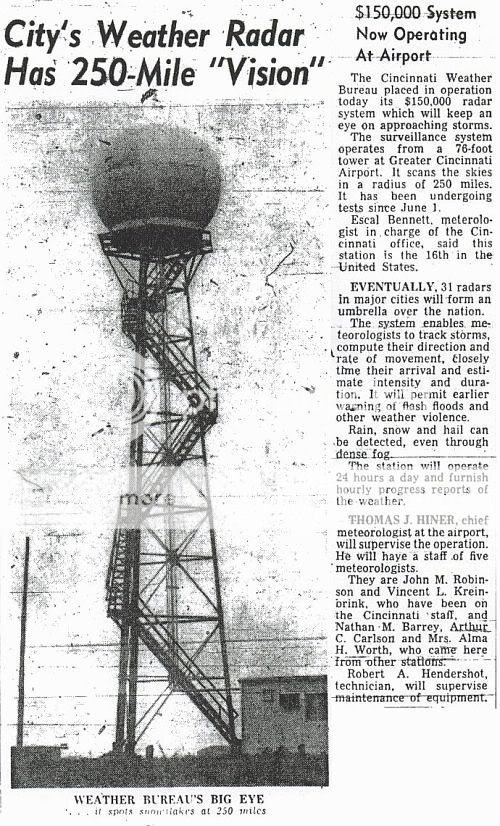
WSR-57 installation at Greater Cincinnati Airport in 1960
wsr-57_installation-small.jpg
 
Thank you so much for the explaination.

up here in central new york after the 1998 labor day derecho, one of my
local tv stations channel 9 (wsyr) bought a tv doppler radar. Which was the first exposure to this idea and was surprised tv station's could have thier own radars. The chief meteorologist's (Dave Eichorn) for those who may of heard of him. Reasoned that since syracuse,cortland and other
points in cny were on the frignes of KBUF,KTYX,KENX radars. Also the fact back in 1998 the radar images were still delayed via 3rd party vender. So they got the radar from Enterprise Electronics corp. I emailed my nws office and the SOO gave me a good overview on tv dopplers. I also emailed the chief met and he told me of the radars specs. Just before channel 9 got thier unit, a rival station bought a rockwell collin's radar unit. This unit looks horrible in its resolution and during lake effect snow event's hardly can detect any precip beyond 20-30 miles away from the unit. I also noticed that moderate precip shows up as red on thier display.
While 88-d and the channel 9 unit show it in good detail and its actuall reflectivity. Could this be because, the rockwell system that the rival station is using, does it have a weaker signal strength so there is greater anttenuation(sp)?. The chief met of channel 9 who has the EEC doppler unit say's they operate at 250,000 watts I think, which he said is the max allowed for non-government radar, I cannot remember the band width it operates on. I also heard that EEC built some of the nws radar units.

Also, two more questions that I thought of while seeing replys. How early did tv stations have the ability to have thier own "live" radars or atleast thier own radars. Also, do some tv stations just have regular weather radar or are all of them doppler units and how effective are they?. Also who is the highest quaility private wsr manufacturer?.

Sorry for a few more questions. I am just very intrigued.

Thanks

Jer
 
Originally posted by Jeremy Miller
The chief met of channel 9 who has the EEC doppler unit say's they operate at 250,000 watts I think, which he said is the max allowed for non-government radar, I cannot remember the band width it operates on. I also heard that EEC built some of the nws radar units.

Also, two more questions that I thought of while seeing replys. How early did tv stations have the ability to have thier own "live" radars or atleast thier own radars. Also, do some tv stations just have regular weather radar or are all of them doppler units and how effective are they?. Also who is the highest quaility private wsr manufacturer?.

250 kw can't be the limit for radar since a few companies offer units with up to 1 megawatt of transmitting power. I believe EEC did construct the Evansville, IN radar (installed 2002/2003). Someone else here might have more details about that.

WLW-TV (now WLWT) bought a Decca aircraft radar in 1955 and had it converted for precipitation detection. This was five years before the Cincinnati Weather Bureau got their radar. Most TV radars have probably had the Doppler feature since the 80s, again someone else here might know more about that.
 
Originally posted by Mike Smith

The WSR-57 was the first radar specifically designed for weather detection. The first was installed in MIA (if I recall correctly) and the second in Kansas City. There was a major problem with the latter installation. They put it on top of the old Federal building at 9th and Walnut downtown and (pay close attention as this is counterintuitive) it was nearly useless for seeing storms around KC as the ground clutter went out 50 miles. Other factors equal, the higher up you put a radar antenna, the MORE clutter you have.

I forgot to write earlier that one of the proposed sites for the Cincinnati WSR-57 installation was the Carew Tower (tallest building downtown).

Here's some more images (click for larger version)

This is the MDR (manually digized radar) grid chart for the CVG site (250 mile range). Typically, only blocks within 125 miles would be coded


These are PPI overlays (similar to what Morgan Palmer posted earlier)

125 mile


250 mile


Dennis Smith of TWC next to the Athens, GA console


Athens, GA PPI scope (with grease pencil markings)


I think the rest of these are from a Kavouras brand display

MCI radar at 180 mile range


MCI radar at 60 mile range


FAR radar at 180 mile range (precip is all snow)


These next two are a bit fancier with colored backgrounds and full city names

LIT radar at 180 miles (note the intense ground clutter pattern)


GGG radar at 180 miles (that might be AP west and northwest of the site)
 
Back
Top