doppler radar/PUPS display and wsr-74 question

Joined
Feb 8, 2006
Messages
42
Location
Cortland, New York, USA
This question is toward those who've worked in or who are working
in a NWS office or if any of the members here can answer these for me.
I'd truely appreciate it.

I remember what I wanted to ask of the forum last time in my previous
post. Do NWSFO's still use the PUP's display's for viewing wsr data?, or do they just use the AWIPS short-term terminals for this and I am not sure if I have heard this from somewhere or if I was thinking of it. If the doppler is displayed on the AWIPS terminal if the doppler detects a TVS or whatever threshold that is set, would it automatically issue a warning through a certain program?. Or is it all personel driven?, ie: having to go into warngen and issue the warning from there manually?.

My second question is about the wsr-74 ( I believe that is what the nws ran before going to the 88-D units), did these systems have the live sweep?. was there a color display with those units and how much antennuation(sp) was there compared to the 88-D and lastly, why do
the TV (privately operated) doppler radars use live sweep, when wsr-88D
I believe doesnt have the live sweep mode (please correct me if im wrong). I know "why" the media uses the live sweep, for appealing
weathercasts.

Well those were my questions. That I couldnt remember in my previous post. Again, I want to present myself as a serious scientific based person and not someone that bring's up event's that are hard to investigate scientifically.

thanks,

Jeremy
 
"Do NWSFO's still use the PUP's display's for viewing wsr data?"

No - AWIPS.

"If the doppler is displayed on the AWIPS terminal if the doppler detects a TVS or whatever threshold that is set, would it automatically issue a warning through a certain program?"

Absolutely not... A TVS does NOT mean there is a tornado, or that a tornado is even likely.

. Or is it all personel driven?, ie: having to go into warngen and issue the warning from there manually?.

"why do the TV (privately operated) doppler radars use live sweep"

Because they are actually showing the radar live. TV radar <> 88D.

"when wsr-88D I believe doesnt have the live sweep mode (please correct me if im wrong)"

Level II data is sent in 100-radial packets, so some TV stations slow down the display and use the sweep to fake it.

- Rob
 
If I'm not mistaken, most TV radars only scan one tilt (usually the lowest). This is much unlike the WSR-88D, which completes a volume scan, with many elevation tilts (complete one scan at one particular level, then change the elevation and scan again, then change elevation angle again, etc). Most TV viewers don't care about the reflectivity field in the mid-upper levels, since few are ever looking for BWERs or other features. Heck, I think most viewers don't even care about reflectivity -- they just know that red means heavy rain and green means light rain. For meteorologists, however, one elevation level doesn't reveal a whole lot, and volumetric analysis is much preferred. Since the 88d is a parabolic dish system, it needs to scan, and thus it's update times are limited by it's physical rotation rate and the scan strategy (VCP) used.

I am curious about the scan strategy (or 'sample' strategy, since a 3-antenna system wouldn't require any physical movement) being developed for the phased array radar. In this case, physical rotation rate won't affect scan times... Of course, if each radar system only gets one or two antenna/antennae, then they'll still need to physically scan.
 
Re: WSR-74C. The radar itself was made by Enterprise Electronics Co. and I purchased the first operational unit for KARD-TV (now KSNW) in Wichita in 1975. It had a digital video integrator processor, so it had a six step DVIP display, but they were shades of gray, not color. It was the first digital radar.

You might be thinking of the colorizer that we attached to it in July, 1976. It was manufactured by Technology Service Corp. of Los Angeles. Both the radar and the TSC colorizer had live (polar coordinate) sweeps.
 
Hi mike,

Thanks for the reply, unfortunately i wouldn't remember 1975.
Since I had not been born yet. I was born in '83. I vaugly remember
mid-late '80s radar displays on news casts. I also am interested in the history of the weather service and radar technology. At any rate thank you for the input folks. I am not sure what level-III data is and one more thing. What does IMO and IMHO mean?

thanks guys
Jer
 
Speaking of old radar displays, I remember seeing a thread somewhere around here that had pictures of radar displays that tv stations used in the 80s/early 90s. It was a very interesting thread, but I can't seem to find it at the moment.

Anyone know which thread I'm talking about?

(IMO= In My Opinion)
(IMHO=In My Humble Opinion)

Here's a link to that other thread
http://www.stormtrack.org/forum/viewtopic.php?t=9433&
 
My second question is about the wsr-74 ( I believe that is what the nws ran before going to the 88-D units), did these systems have the live sweep?. was there a color display with those units and how much antennuation(sp) was there compared to the 88-D and lastly, why do
the TV (privately operated) doppler radars use live sweep, when wsr-88D
I believe doesnt have the live sweep mode (please correct me if im wrong).

In terms of the attenuation question, it would depend on the WSR-74 model. The 74C model was a 5 cm radar, which did have some signification attentuation at times. The 74S was a 10 cm radar, like the 88D. I used a 74C for a few years in Springfield, IL, and remember that heavy rain overhead really caused the displayed intensities to drop off.

The WSR-74S and the WSR-57 models were the "network" radars, while the 74C was a "local warning" radar. (Can't remember if there were any 74S's were actually local warning radars.) The network sites would prepare "radar observations" (now done automatically) hourly, while the local warning sites were only required to prepare these obs when filling a hole caused by a nearby network radar outage. However, each staff member at the local warning radar site had to compose 30 of these observations every 6 months, in order to stay certified.

Chris G.
 
The WSR-74S at LBB was a local warning radar. I believe there were 1 or 2 others.

With regard to the history of radars in the NWS, here is a brief summary...

The first radars were converted aircraft radars after WWII. The WSR-1 was essentially a converted aircraft radar. There was a WSR-3, but I don't know much about it.

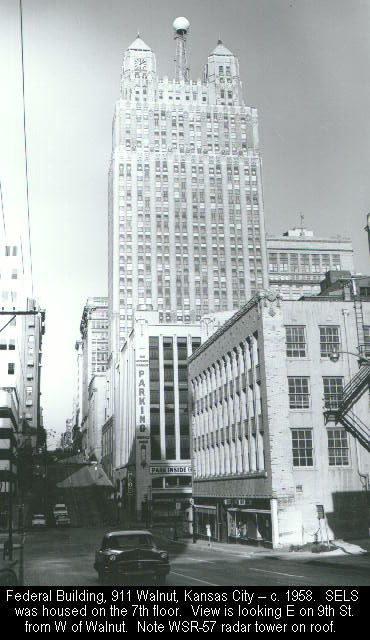
The WSR-57 was the first radar specifically designed for weather detection. The first was installed in MIA (if I recall correctly) and the second in Kansas City. There was a major problem with the latter installation. They put it on top of the old Federal building at 9th and Walnut downtown and (pay close attention as this is counterintuitive) it was nearly useless for seeing storms around KC as the ground clutter went out 50 miles. Other factors equal, the higher up you put a radar antenna, the MORE clutter you have.

The -57 network was concentrated in the tornado and hurricane belts with little coverage west of the Rockies.

There were many more complaints about inadequate coverage than there are today, so the WSR-74 series of radars was developed as "gap fillers." These went in places like CNK, TUL, etc. and were only operated during adverse weather. The WSR-74C radar for LAX was on top of the Federal Building in Westwood and had a severely limited view due to the mountains. The -74C for ATL was on a building between Hartsfield and downtown. The latter two radomes are still there today, as is the -57 dome at MCI.

A couple of points: It was the private sector that developed color radar, radar "networks" (i.e., neither the -57's nor the -88's were in initially made into a network by the NWS), gauge-adjusted precipitation estimation, etc. The first Doppler radars were deployed by the private sector in the 1980's before the -88D's.

So, the development and utility of radar data has very much been a function of both the NWS and the private sector. While there have been bumps, this has been a pretty good example of synergy between the public and private sectors.
 
The NWS in Grand Rapids office had a color display made by Alden
to receive the radar images from Muskegon which had a WSR-74
radar. Alden was a private weather company that no longer exists.

Before they got the color monitor, I remember the office getting
radar images from DIFAX, and they would have to change the paper
often.

Mike
 
As we reminisce, I pulled these laminated radar contouring charts out of my box o' memories. These were given to me by Mike Young, then MIC of the WSO Abilene, TX not too long before the office and their 74C were decommissioned.

Thought I'd post these for posterity. I had to stitch in Photoshop as the charts are too big to scan in one piece. I'd say they are exactly one foot by one foot.

(ADD: I laminated them later. They were not laminated when used for contouring. BTW, these scans are not zoomable without significant loss of quality. If you need a hi-res version, let me know.)

MP

abi74c1.jpg

abi74c2.jpg

abi74c3.jpg
 
Mike Smith wrote:
The WSR-57 was the first radar specifically designed for weather detection. The first was installed in MIA (if I recall correctly) and the second in Kansas City. There was a major problem with the latter installation. They put it on top of the old Federal building at 9th and Walnut downtown and (pay close attention as this is counterintuitive) it was nearly useless for seeing storms around KC as the ground clutter went out 50 miles. Other factors equal, the higher up you put a radar antenna, the MORE clutter you have.

SPC has a picture of the 911 Walnut, KC installation:
walnutfb.jpg
 
Why is (was in this case) when a radar is placed higher in elevation, does it have a ground clutter problem?. It would seem to me if its above the tree and building line it would not detect ground objects as easily than those on the ground. Can you shed some light for me here?.

Thank you.

Hope everyone is having a good weekend, it's very cold up here in
central ny state. Its 18*F ATTM unofficially at the town of truxton elementary school, according to the live weather feed thru wxbug.
I use this for basic local sfc conditions, since my county only has an
AWOS III and its not avalible on the net. So I have to rely on reports from
KITH,KSYR and KBGM. Anyway, I'am sick of the cold winter, I want late spring-summer convection and the occasional warm summer sunny day.

Well enough of my rambling, I hope someone can explain why you
get more ground clutter the higher you get?. Does this issue also affect the 88-D units?. Lastly, is this the problem with radar coverage in the pac northwest?.

Jer
 
The reason the radar was placed on top of the old Federal Building because the National Severe Storms Forecast Center (NSSFC) was in that building at the time the radar was installed, as was the KC WFO. At the time, it was very expensive and would create reliability problems to "remote" the signal (remember, this is the 1950's).

NSSFC was later moved to the "new" Federal Building but the radar remained at 9th and Walnut. What I can't remember was whether the radar commands and signal were microwaved or land-lined between the two buildings. At the time, there were strict distance limits for land lines, which is why the NWS had to build entire offices in places like Monett, MO, Limon, CO and Centreville, AL rather than remoting the radar controls from Springfield, Denver and Birmingham.

The Kansas City WSR-57 was moved to Kansas City International Airport as was the KC WFO.

As to why there is more ground clutter with a higher radar installation, it has to do with the way radar works...

While it is possible to use different designs, the WSR-57, 74, and 88 radars use a single parabolic antenna to both transmit and receive. A parabolic antenna does not and cannot produce a perfect signal. Energy leaks off the sides called "side lobes."

The radar transmits a brief "pulse" of energy, usually for about 4 millionths of a second. When the radar is in transmit mode, it cannot receive signals. So, if the radar is close to the ground, when the side lobes strike hills, buildings, etc., the radar is still in transmit mode when the reflected signal returns to the antenna so it is "invisible" (i.e., the radar is still transmitting). But, if the radar is high above the ground, the radar has time to return to "receive" mode. So, the side lobes are received and displayed and, because the radar is higher up, the side lobes can strike ground farther away and still come back to the antenna.

As I mentioned in my first post, this is counterintuitive. But, it is important as it is a vital aspect of radar siting.
 
Back
Top