• While Stormtrack has discontinued its hosting of SpotterNetwork support on the forums, keep in mind that support for SpotterNetwork issues is available by emailing [email protected].

Dissecting the Bowdle Mesocyclone

Jeremy Perez

Supporter
Joined
Aug 31, 2008
Messages
344
Location
Flagstaff, Arizona, USA
Ever since seeing our first tornado near Bowdle, SD, I've been amazed by the complexity and power of the storm we saw that day. I keep coming back to some of the photos we shot, trying to identify the wound-up array of structures while visualizing the dynamics.

I've labeled a couple images below with what I think is going on. Besides the labels, I've depicted my take on inflow (red), FFD (blue), and RFD (purple). I'd really appreciate having any mistakes pointed out, or if I've missed noticing something. (If anyone wants to, feel free to mark up the image & repost it here.)

The first image is shot facing northwest prior to the first tornado spinning up. (Not sure if that structure is actually a collar cloud.)

img20101117_MesoAnatomy600px.jpg


img20101117_MesoAnatomy600pxLBL.jpg


Larger images: Original || Labeled

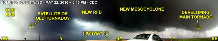
This next image is shot facing north.

img20101117_MesoAnatomy2_400px.jpg


img20101117_MesoAnatomy2_400pxLBL.jpg


Larger images: Original || Labeled

Thanks for taking a look!
 
Good day all,

I also noticed a (possible) additional tornado that may be added. This was while the storm was just west of Bowdle, SD by a few miles, and crossing Highway 12 after 6:15 (around 6:23 to be exact).

bcpn0522.jpg


Above: Annotated diagram, grabbed from 4 video frames near 3:46 in the video, and put into a panorama and enhanced, a possible (satellite?) tornado can easily be seen to my NW. I had an idea this feature was there while filming (at the corner of my eye) but saw it in greater detail when I reviewed the video.

Note: In the video of this event, the link is repeated below, the composite (panorama) was grabbed from the HD frames near 3:46 in the video, where the pan from SE to NW shows the possible satellite / old meso / tornado. The directions are also annotated as well. This is also the same time the storm was "cycling" between the stove pipe / barrel tornado south of Highway 12 and the violent wedge that struck the northern fringes of Bowdle at about 6:30 PM and after.

This is why we always keep our heads on a swivel in such violent storms rather than focusing on the main "event" (tornado).
<!-- / message --><!-- sig -->

Hmmm you aren't on 12 are you? Are you on 47 or one of those dirt roads. Just trying to get a feel of where you are exactly so I can compare to me and start looking at video. I think I was so caught up in the large wedge developing that I didn't bat an eye anywhere else but there. Other than the occasional look over my shoulder to see if something else was lurking.
 
Ever since seeing our first tornado near Bowdle, SD, I've been amazed by the complexity and power of the storm we saw that day. I keep coming back to some of the photos we shot, trying to identify the wound-up array of structures while visualizing the dynamics.

I've labeled a couple images below with what I think is going on. Besides the labels, I've depicted my take on inflow (red), FFD (blue), and RFD (purple). I'd really appreciate having any mistakes pointed out, or if I've missed noticing something. (If anyone wants to, feel free to mark up the image & repost it here.)

The first image is shot facing northwest prior to the first tornado spinning up. (Not sure if that structure is actually a collar cloud.)

img20101117_MesoAnatomy600px.jpg


img20101117_MesoAnatomy600pxLBL.jpg


Larger images: Original || Labeled

Thanks for taking a look!

I think you have the general structure correct, but like Andrew mentioned, I'm not sure the collar cloud is there, especially since there is no obvious tornado in the image. Granted the term "collar cloud" is somewhat new to me and rather ill-defined, but I think Gene Moore's account of the 13 June 1998 tornadoes illustrates it and helps me understand what it is. It also is rather tough to discern whether the RFD has fully wrapped in the picture, but for sure there is a clear slot on the left edge of what you marked as "RFD". Also, I'm not sure about the tail cloud. I always thought tail clouds were attached to the wall cloud, thus pointing the other way (towards the FFD). I could be wrong on that, though. The picture is just a little far away to delineate some of the smaller-scale structure associated with the tornadic region.
 
Andrew, Jeff, thanks!

These were the sources I looked up regarding "Collar Cloud":
Wikipedia (heh, I know)
Geography Dictionary
NOAA Glossary
They seem to define it as a ring of cloud surrounding the upper part of the wall cloud. Although after checking Jeff's link, and some others I've just hit, it looks like others use it to describe an expanded cylinder of condensation where a funnel connects to the meso. It does sound like there is some confusion about it so I probably won't worry about ID'ing it as a structure in the future.

As far as the tail cloud/beaver tail goes, I was picking up on an uneven, fragmented stream of cloud flowing in very low into the base of the meso, where the wall cloud seems to be forming (easier to see in the larger image). Since the other one looked like it was intersecting at a higher level, I thought that might peg it as a beaver tail. Not sure though.

Christopher, that's an interesting view, and might explain why that huge pillar of a meso seemed to last so long when it looked like it was completely occluded...which is to say there was more going on underneath that I didn't see.

Jim, it really was great to see it explode and evolve from that first burst of cumulus!
 
Great shot, Jeremy. I love seeing structure shots of that storm as I was too close to the storm until after the Bowdle wedge.

In order to maintain position on the storm and because of the road network, I was forced to drive under the RFB and was under the RFD clear slot at the time you shot that picture. Panning my video camera, here are some labeled grabs of the storm from my perspective at the time:

RFB = Rain Free Base
RFD = Rear Flanking Downdraft
FFD = Forward Flanking Downdraft

Image2.jpg

Image3.jpg

Image4.jpg

Image5.jpg

Image6.jpg

Image7.jpg

label2.jpg

label3.jpg

label4.jpg

label5.jpg

label6.jpg

label7.jpg


The first shot was a couple minutes before your photo, and the last one was a few minutes after your photo. You can recognize that band of clouds in the second shot as the feature you've labeled a tail cloud. I believe this was more of a roll cloud feature though. Its interesting though that this feature actually formed behind the RFD clear slot I was driving under. There must have been another downdraft behind the one I was under that was kicking up those clouds. If you follow the arrows, I believe, like most rolls clouds, a combination of the FFD and inflow was being forced over the RFD on the back edge of the storm and creating those clouds. They look more like a conventional shelf cloud in the next shot, but the northern tip of appears to be an inflow feature.

The lowering on the first shot is probably a similar feature that possibly spawned the tornado that Chris identified in his video from several minutes later. This lowering was actually behind the RFD and wall cloud/circulations that produced the first tornadoes that many saw, and may have been the remnants of the first cycles of the storm that pushed north into the storm's forward flank. The feature was definitely inflow based, although I wouldn't say it was a funnel or tornado at the time that I shot it, probably more of a wall cloud type feature at that point sucking in the rain cooled air from the forward flank to the north.

The little curlie-cue in the first shot is something I noticed in my video, and have seen it a few times on the back end of wall clouds, probably where the inflow and RFD are interacting to create a little eddy.

Here's GPS and radar at the time of the above shots:
cap437.jpg
 
Last edited by a moderator:
Great shot, Jeremy. I love seeing structure shots of that storm as I was too close to the storm until after the Bowdle wedge.

Image3.jpg

This is a much better picture of that feature, Skip. At this distance, there's enough detail that it looks to me like, as you said, a roll cloud associated with the outflow boundary from the front flank of the storm. It is probably indeed being ingested into the updraft (moving right to left) with all of its baroclinically-generated horizontal vorticity.
 
10052212.jpg

First attempt at a wall cloud from Bowdle storm.... No beaver tail, still "higher" based, but has scud rising into the RFB.

10052218.jpg

Base lowers, wall cloud visible with broad rotation. Nice beaver tail. Inflow at the time was on the order of 15 kts.

10052221.jpg

Well defined wall cloud with moderate to strong rotation. Rfd starting to wrap around.

10052224.jpg

About 10 minutes later and much closer (this feature was 2 miles to our WSW). Violently rotating wall cloud with large funnel descending. Dust is rotating underneath so you can even call this the first tornado albeit not fully condensed.

10052229.jpg

Tornado drops.

Rapid succession from first wall cloud to tornado. 15-20 minutes.
 
This is a much better picture of that feature, Skip. At this distance, there's enough detail that it looks to me like, as you said, a roll cloud associated with the outflow boundary from the front flank of the storm. It is probably indeed being ingested into the updraft (moving right to left) with all of its baroclinically-generated horizontal vorticity.

You can see this feature in motion at about 4:40 in this timelapse:

 
Good day all,

Hmmm you aren't on 12 are you? Are you on 47 or one of those dirt roads. Just trying to get a feel of where you are...

Yes, Danny ... That was Highway 12 just east of the "T" where Highway 47 meets 12 from the south about 3-4 miles west of Bowdle, SD. The rapidly developing wedge tornado was underway about 1 mile to my east at that time.

I would say that this storm literally went from BLUE SKY to TORNADO in about an hour!
 
Good day all,


Yes, Danny ... That was Highway 12 just east of the "T" where Highway 47 meets 12 from the south about 3-4 miles west of Bowdle, SD. The rapidly developing wedge tornado was underway about 1 mile to my east at that time.

I would say that this storm literally went from BLUE SKY to TORNADO in about an hour!

Hmm interesting Chris. We were owned by RFD and downed lines so I couldn't be much help to you. Did anyone actually see the first tornado dissipate (I'd imagine so)? The tornado was moving NNE pretty quickly and we paralleled it for a good mile before we noticed it was getting closer so we stopped and watch it cross onto the highway. From there I noticed it occluded and went north and then I lost sight of it. At first I thought the Bowdle wedge was just the first tornado later on, but a multitude of evidence proved otherwise. Did anyone else see the feature in Chris' panorama?
 
Stephen, that's an amazing view of the RFD sweeping the whisps on that huge meringue log downward.

Skip, many thanks for your annotated photos. They've helped me see several things that I would not have realized were going on in there--
On your NW-facing photo, it's great to see that low roll cloud feature up close.

The rest of the images look like the RFD has wrapped almost completely around the meso, leaving just a narrow slice for the inflow to squeeze into the circulation.

Your N and NNE facing images show a large, laminar inflow cloud, that is perhaps the actual beaver tail for this storm, and I think I see it now in my image. If that's right, then I suppose that makes the lower, longer, lumpier inflow cloud in my image the tail cloud (which appears to be hidden in your image behind what you labeled as the "RFB/New Wall Cloud). Here's my next stab at it, without all the vectors. (your time lapse is incredible, btw!)

img20101119_MesoAnatomyDBL.jpg


Thanks everyone for all the supporting images, videos and helpful discussion.
 
Back
Top