Dangerous Hurricane Patricia poised to hit Mexico

Tim Paitz

EF2
Joined
Apr 27, 2015
Messages
190
Location
St. Louis, Missouri
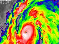
Earlier today Patricia underwent a rapid intensification as she went from a 65 mph, 994 mb tropical storm into a 100 mph, 973 mb hurricane and is forecast to become a major hurricane by tonight. Patricia is poised to turn to the northeast and landfall somewhere between Manzanillo and Puerto Vallarta possibly by tomorrow night and may be a category 4 hurricane at landfall. Right now it's in a very favorable area marked by little wind shear.
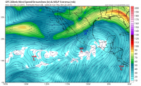
3932f409b43f8118d95751a2ff2fdbc7.png


It does look pretty good right now.

c6d84af6907770a8d6262ca0b40a90ca.gif


The only other 2 Mexican Pacific category 4 landfalls as far as I know were in 1957 near Mazatlan and Hurricane Madeline in 1976 near Zihuatanejo.
 
It surely turned into a hurricane rather quickly. Its projected to make a sharp turn with possible peak winds of 140 Mph. I noticed that parts of the hurricanes edge is already hitting land. I hope the local residents are prepared for this storm.
 
It surely turned into a hurricane rather quickly. Its projected to make a sharp turn with possible peak winds of 140 Mph. I noticed that parts of the hurricanes edge is already hitting land. I hope the local residents are prepared for this storm.

It's only about 120-130 miles off the coast.
 
Satellite presentation is SOLID... upper 4/low 5 and improving, says I. Anyone going to brave mexican travel to chase this guy? Landfall looks like right at sunset or just after dark, unless she jogs east or picks up a speed a bit.
 
Satellite presentation is SOLID... upper 4/low 5 and improving, says I. Anyone going to brave mexican travel to chase this guy? Landfall looks like right at sunset or just after dark, unless she jogs east or picks up a speed a bit.

Josh Morgerman is scouting the coast right now...... no surprise there. He always goes for those Mexican pacific 'canes. XD
 
Satellite presentation is SOLID... upper 4/low 5 and improving, says I. Anyone going to brave mexican travel to chase this guy? Landfall looks like right at sunset or just after dark, unless she jogs east or picks up a speed a bit.

I know chasing is general is dangerous but wouldn't a category 4 hurricane be extra dangerous to intercept? I would imagine it would be difficult to chase anything in torrential rains with land fall speeds of 140 MPH. Not to mention the terrible flooding that will come with it and the debris flying around you during this intense event. I would even think surprise tornadoes would be hard to spot.
 
This thing is looking mightily impressive on IR right now. Current Dvorak estimate is T = 7.6 (max is 8.0, which was actually surpassed by Haiyan).
fd8cc508b57ebe9f431de1979e6b7012.jpg
8eaa5ff0151888b5da2c94b3210a9de6.png

It is also over some very favorable SSTs. The pink shades here are in the 30-31˚C range.
73cfe939f24d70e591412ed89e3cdd73.png

Several tracks have this coming quite close to Puerto Vallarta, which would obviously be a cause for concern. Main questions for intensity will be a somewhat increase in shear prior to landfall and also a likely upcoming ERC.

Also regarding Cat 4+ Mexican landfalls, there are 4 known -> Kenna '02, Madeline '76, the '59 Manzanillo hurricane (estimated to have been the only Cat 5 landfall in the E Pac and is also the deadliest with at least 1800 fatalities) and the '57 Mazatlan hurricane.
 
This hurricane looks like it got a lot bigger from earlier! Wow this is an ugly looking storm.
 
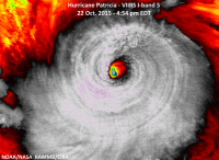
What a monster! this storm is now tied for the second best looking storm I have ever seen, a near twin of the mighty Wilma. From the satellite and its size, i'd estimate 180mph winds and ~895mb. The smaller size might keep the pressure from record lows seen in other storms.
 
With the recon just making its first pass, looks like 180mph sustained surface winds and 890mb. Not to brag or anything:)

An insane 17 degree Celsius difference between eye and eyewall.
 
Wow, so this is officially the strongest pacific hurricane on record now. I am really worried what its going to bring when it makes land fall.
 
At the current time of this post the hurricane has a max winds of 200 MPH with gusts up to 245 mph. This is insane.

Its official; this hurricane is the strongest hurricane in all of history period.
 
Last edited:
What a monster.... I would love to be able to fly in the Hurricane Hunters aircraft and get a look at this thing. It'll be sad to see such a beauty die once she makes landfall, not to mention the devastation it is going to cause once it hits.
 
odds are it weekens some before landfall. If theres a SOLID steel reinforced concrete building to hide in/behind above say 25 feet MSL, I think he can pull it off. While scary, theres also a powerful allure to chasing one of the all time storms.
 
odds are it weekens some before landfall. If theres a SOLID steel reinforced concrete building to hide in/behind above say 25 feet MSL, I think he can pull it off. While scary, theres also a powerful allure to chasing one of the all time storms.

Yes, if it undergoes an eyewall replacement cycle like odile did. He scouted places in Perula, La Fortuna and San Mateo and couldn't find any substantial buildings yet. However, Perula's going to get inundated with storm surge, possibly La Fortuna too. San Mateo's buildings are poorly constructed based on what I saw from StreetView.
 
Thats rough. You'll want a few too... a little eyewall like this, a little jog, without a backup or 2 he could be completely missed. Maybe east a bit, with this latest wobble?
 
I heard when it makes landfall winds are going to be around 150 MPH. I am watching a stream of a beach right now and the waves are intense and it isn't even here yet.
 
Hate to miss this one but I'm not a fan of late afternoon into night-falling hurricanes as there is little in the way of visual opportunities. The other problem is finding a survivable location. With such a compact eye wall, it would be a real challenge to remain in the onshore wind flow. The biggest potential loss of life will likely be flooding and mudslides as it moves inland.
 
Yes, this is on the extreme end of the scale of hurricane intercepts: a Cat 5 in a generally poor infrastructure area with corrupt police and drug cartels. The worst part of that will be the aftermath.

I'd want to just buy an old pickup towing a steel reinforced concrete saferoom on a trailer, deploy it for the eyewall, then have a chartered helicopter just swoop in and pick me up with a rope ladder afterward. I wouldn't want to stay long.
 
I would not be surprised to see some weird and "unplanned for" damage, possibly causing some serious issues. For example, during Hurricane Katrina in Biloxi, casino barges and ships were carried inland and plowed into buildings. I have not been in that region for many years, but I do recall some major high rise buildings set right on the beach. Hopefully, they completely evacuated those buildings. My understanding is that some hotels could not be evacuated so they are requiring guests to stay in their rooms, or maybe even more disturbing, moved them into the mountains. There could easily be 20 inches+ of rain hitting the mountains creating insane floods and mudslides.
 
Back
Top