Conveyor belt!

Joined
Jun 21, 2004
Messages
1,528
Location
Kearney, NE
I was going to post this in the TA, and actually did for a moment, but decided to hold off until there's at least an INVEST. Posting in there for tropical waves could clutter stuff up!

That said, there is a bit of a conveyor belt going on right now off of west Africa, which is bizarre for this time of the year. There is TD 5, then east of it a consolidating wave, and then east of that a wave with a low evident on quickscat.

We'll almost surely have an Emily soon, it's slightly likely we'll have a Franklin, and it's not out of the realm of possibilities that we'll also have a Gert very shortly after that. Any climo buffs out there? What's the earliest we've ever had five named storms in a season? Six? Seven? Yikes!
 
If we get an Emily soon, it will be the 3rd time since 1960 that the 5th named tropical storm occured before the end of July. Last time this happened was in extremely active year 1995, but the 5th system (Hurricane Erin) did not become a TS until July 31, and in 1966, the 5th storm (Tropical Storm Ella) didn't become a TS until July 24. So basically, if Emily forms this week, this season will set ANOTHER all-time record!!
 
This is insane. I have never seen such activity this early in the hurricane season, especially the 'Cape Verde', which usually doesn't become active until August. Is there anything particular that is causing this surge in activity?

I feel for the people who reside anywhere along the Gulf Coast and Atlantic. This looks to be the worst hurricane season, yet.
 
I can hardly wait to see September... if its this active now, and it maintains this kind of pattern, we could be in for an interesting year to say the least.

Anyone else wondering if we can max out the name list?
 
I think the odds are high that we will eventually have a Cat. 5 hit the US sooner than later if this active pattern continues. You just can't keep having hurricane after hurricane weaken when it approaches the coastline. Sooner or later the luck will run out. The more hurricanes - the higher the odds. Any thoughts on this?

Mike
 
The reason for the increased activity way out in the deep Atlantic is because of a chain effect of two things. First of all, notice the convection coming off of Africa. The convective "blobs" are all already low-pressure systems! They are not tropical waves. They are all part of a monsoon trough of low pressure that extends east-west. It is displaced further north because of the anomalously higher SST's in the central Atlantic. The extra heat and evaporation tend to pull the monsoon trough northward, thereby exposing the embedded low pressure systems to a more favorable environment for development.
 
I think the odds are high that we will eventually have a Cat. 5 hit the US sooner than later if this active pattern continues. You just can't keep having hurricane after hurricane weaken when it approaches the coastline. Sooner or later the luck will run out. The more hurricanes - the higher the odds. Any thoughts on this?

Mike

Agreed. People need to heed these warnings, as sooner or later, another Cat 5 will hit. And it could hit in one of the "Top 5 Most Hurricane-Vulnerable Cities" - Houston, New Orleans, Miami, New York, or Tampa. A major hurricane that directly hits any one of those cities will cause catastrophic damage. A Cat 5 will wipe those cities off the map.

Back to the topic, the train of tropical waves/lows seems to be calming down now. I have heard rumors that this increase of tropical activity may be caused by a positive MJO phase (or is it negative? - anyway, the phase that favors a ridge in the east, trough to the west) . Once that reverses we should see this end. Indications are that it is reversing, and satellite images confirm that - look at the Africa satellite and you will see that there are no more waves poised to move off the African coast - more typical to July.
 
I think the odds are high that we will eventually have a Cat. 5 hit the US sooner than later if this active pattern continues. You just can't keep having hurricane after hurricane weaken when it approaches the coastline. Sooner or later the luck will run out. The more hurricanes - the higher the odds. Any thoughts on this?

I think you are correct. The big fear I have is the fact we have not had a real intense hurricane make landfall in a long...long...long...time. The last strong Cat 5 that hit the U.S. was in 1969 with Camille before that it was 1935 with the unnamed Keys storm. For those that think Andrew was as intense as it could get just look at the pressure of the 1935 storm (892mb). That is 30mb difference!! The difference between Hurricane Andrew and Bret (1999) is 30mb to give an example. In Camille there were recorded (not estimated) wind gusts at 210mph or equal to an F-4 tornado. If you assume the 34 years between the strong cat 5 hurricanes are average than we are due since it has been 36 years.
 
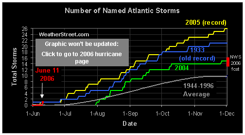
Sure is a crazy year so far. Found this link on another board:

named-storms-cimatology.gif
 
I noticed the other day that water temps in the western Gulf are quite warm (90 degrees). I'll take a chance here and say the western Gulf is going to get a really big one this year before it is all over. Galveston to Brownsville. It has been way too quiet in that area.

Mike
 
Back
Top