• While Stormtrack has discontinued its hosting of SpotterNetwork support on the forums, keep in mind that support for SpotterNetwork issues is available by emailing [email protected].

Central/southern USA winter storm: January 23-26, 2026

Joined
Jan 14, 2011
Messages
3,617
Location
St. Louis
For the sixth year in a row, the deep South will see a major winter weather event - and this year's storm looks to be potentially historic if some ice accretion forecasts verify. On the full-column-below-freezing side of the storm, a swath of 12+ of snow is expected from Oklahoma to New Jersey. To the south of this, a significant warm nose overtop of the arctic air will introduce a long-duration stripe of sleet/freezing rain from Texas to Georgia. The precip type in this band is in question, with models wavering between a sleet-heavy mix to all freezing rain depending on the depth of the warm nose and artic air. The latter could bring a historic ice storm to many areas that see very little winter weather.
 
Watching this closely here in the Philadelphia area, where a separate group of weather geeks is blowing up the Philly Wx forum and even the local AFD is calling it a lock that there will be be an impactful snowfall, although it is ~5 days out. The Philly Wx forum loves big snowstorms way more than thunderstorms, but so often around here it’s like Lucy pulling the football away from Charlie Brown, especially with mid-level warm intrusions and the ever-present and oscillating rain/snow line. I’m clueless when it comes to doing my own forecast analysis for winter weather, but just hearing the chatter this seems to be about as close to a sure thing around here as I can remember for many years. So far the only mention of sleet or ice for a portion of the storm’s duration is south of here in the Delmarva and southern NJ. Where I am, in PA but not too far from Trenton NJ, at least right now should be all snow. Ice is no joke; a light coating is great and pretty to look at, but heavy accretion would not be a good thing for the south.

Anyway, looking forward to hopefully experiencing a big snowstorm here, and it looks to be of long duration, from Saturday night perhaps into Monday morning. Awesome that it occurs mostly over the weekend, great to hunker down for a cozy weekend at home with some good home-cooked meals, cocktails or wine, and the NFL conference championships!
 
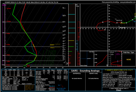
Sleet is certainly not out of the question. With surface temps well below freezing. For example, the EURO forecast sounding as depicted by SHARPpy for Sunday evening in central Montgomery County shows a deep (850 mb to 700 mb) saturated 0℃ layer and a Best Guess of Sleet ... with a surface temp of 20℉.

1769004906609.png

Way too soon to say anything is even close to certain, but, surely a possibility.
 
The NHC is doing recon flights over the eastern Pacific to sample the incoming system to improve model forecasts for this storm:


II. PACIFIC REQUIREMENTS
1. FLIGHT ONE - TEAL 75
A. 23/0000Z
B. AFXXX 12WSE IOP11
C. 22/1830Z
D. 25 DROPS APPROXIMATELY 60 NM APART WITHIN AN AREA BOUNDED
BY: 35.0N 130.0W, 35.0N 110.0W, 15.0N 110.0W,
AND 15.0N 130.0W
E. AS HIGH AS POSSIBLE/ 22/2030Z TO 23/0230Z
 
Something else worthy of attention that I'm noticing also is how much of the snow forecasted to fall in Central OK/AR is looking to be on the wetter side. Basically all the models are in consensus of a Kuchera ratio lingering around or even less than 10, which isn't surprising due to the relatively warm 500mb temperature in the negative teens just ahead of the polar vortex. Considering that most of the infrastructure that far south likely isn't built to withstand several inches to a foot of dense snow, as well as the additional havoc it will inflict to trees/power grids, its starting to look very concerning.
 
Well my post did not age well. This morning NWS had 14” for my area northeast of Philly, while the PhillyWx forum consensus was for a much lower amount due to sleet and freezing rain. Sure enough, NWS reduced the forecast to 10” for me, but part of not going down further is just continuity of forecasting I think… I trust the guys on the Philly Wx forum, which would seem to indicate 6” based on the latest posts. Of course, this likely means more sleet and/or ice, which is not good. Either way, still looking forward to experiencing the storm!

Good thing we don’t see the same spread between SPC and this forum on severe weather events, that I am seeing between NWS Philadelphia/Mt. Holly and the PhillyWx forum.
 
I’m in Bentonville AR. Safe from the freezing rain here, but hoped to not have to deal with this after moving here not too far from the Canadian border. A very real and serious concern I have for others is the potential for losing power when it’s going to get so cold. I pray the electric outages don’t happen.
 
Back
Top