Bondo (Extreme intensification)

Joined
Dec 9, 2003
Messages
4,839
Location
Oklahoma
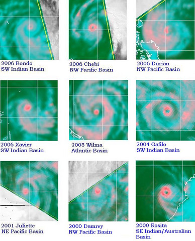
Bondo is a Cat 4 (equivalent) cyclone off the coast of Madagascar. The latest information from various sources puts the max winds anywhere from 110-130kts. The most impressive aspect, to me at least, is that the storm intensified at an extreme rate. Some obs:

18/12/2006 12:00 63.10 10.80 2.0 Perturbation tropicale 1000 25 kt, 46 km/h 35 kt, 65 km/h
18/12/2006 18:00 61.60 11.00 2.5 DEPRESSION tropicale 998 30 kt, 55 km/h 42 kt, 78 km/h
19/12/2006 00:00 60.50 11.00 3.0 TEMPETE tropicale moderée 992 40 kt, 74 km/h 56 kt, 104 km/h
19/12/2006 06:00 59.50 10.50 4.0 Forte TEMPETE tropicale 976 60 kt, 111 km/h 84 kt, 156 km/h
19/12/2006 12:00 58.50 10.70 5.0 CYCLONE tropical 950 85 kt, 157 km/h 119 kt, 221 km/h
19/12/2006 18:00 105kts, 925hPa
19/12/2006 00:00 110kt/155kt, 115mb

I think the first number is the 10-minute wind speed average (either that, or 10m wind --> "Vent moyen sur 10´ maxi"?). Intensity estimates are at http://www.meteo.fr/temps/domtom/La_Reunion/TGPR/saison/03.html

That's an 83mb pressure drop in 30 hours -- impressive. I don't have much in the way of sources for weather in this part of the world, so I'm interest to see if any ST members can provide some links. The RSMC (in France) has the 'duties' in this part of the Indian Ocean, but many of their products are in French, which I don't know. For those who do know French, the page is at http://www.meteo.fr/temps/domtom/La_Reunion/#

The latest vis sat image is available at http://www.meteo.fr/temps/domtom/La_Reunion/TGPR/saison/images/satellite/DerImageSatellite.jpg

An loop of sat. imagery is available at http://cimss.ssec.wisc.edu/tropic/real-time/visir/indian/visirjava05S.html (note, it's a java loop, so it may take time to load).
 
Last edited by a moderator:
Indeed that was quick. Did this even beat Wilma back in 2005? I heard she was a bomb either.

Is there any English observations about it? I don't speak French(I can read it through Babelfish).
 
The most interesting thing about Bondo was when it passed very close to the Agalega Islands (a coralline atoll), as an Intense Tropical Cyclone. The max intensity of eyewall winds at that time was given by JTWC as 130 kt (1-min avg), and by RSMC La Reunion as 105 kt (10-min avg). based on Dvorak (IR) intensity estimates. I think that's the equivalent of a Cat 4 in that basin.

The northern eyewall was only 20 nmi (37 km) south of the weather station. Guess what the pressure drop and max winds were, as the TC passed by? Pressure dropped only 14-15 mbar (depending on your starting point), down to 990 mbar, and highest winds were 28.8 mph (I'm assuming 10-min avg). Here's the weekly history for the weather station, which is at the northern tip of the islands; for the specifics click on the 19th and 20th at the bottom of the page.

I was so floored by this that I stayed at work an extra hour on Wednesday night watching the hourly reports from Agalega come up on Wunderground. I could not believe it when the pressure started rising at the 3am report (7pm my time), but sat imagery showed the TC was moving away at that point.

Happy holidays.

.
 
Last edited by a moderator:
Bondo quite amazingly intensified back to Cat 4 today just off the northwest tip of Madagascar.

Yes -- and waited just until JTWC forecast to weaken (#12), before reintensifying further. :)

Does not look at all good for Nosy Be...this time the island is on the wrong side of the TC.

Regards Wed night, I wouldn't have been so surprised had I looked at the microwave imagery from earlier that morning, which showed a very small intense core (windsat and ssmi).

Sunday update

Briefly reintensified and then fizzled, sliding further south along the coast.

Found a short Reuters news item on Farquhar evacuating prior to Bondo passing through (this was during the ERC when Bondo was forecast to reintensify, but did not, due to wind shear and upwelling).

Once again, appears impact from Bondo may have been minimal. You'd think not, with this and this. Nosy Be station does not report windspeeds on Wunderground, but the pressure drop reported there was only down to 1001 mbar...about a 5 mbar drop, and wind direction from the north as expected. Nosy Be subsequently stopped reporting on the NOAA (NWS internet web source) web site.

Monday update

It appears that Bondo made landfall near Majunga (the Google location of this weather station may not be correct). The highest sustained (10-min?) winds reported on Wunderground at Majunga were at 1300Z, at 45 kt with a gust at 80 kt mph. Pressure bottomed out at 990 at 1400Z. The center became visible on water vapor right after landfall, due to friction with land, and appeared to landfall between 1100Z and 1200Z. However both JTWC and La Reunion (even their 1200Z) have the track still over water.

La Reunion warning 33 noted the landfall: "THE SYSTEM MAKES A LANDFALL IN THE VICINITY OF MAHAJUNGA AT 1215UTC."
 
Last edited by a moderator:
The bit in French is indeed the ten minute wind average. That table looks suspiciously similar to something I posted myself to the S2K forum by the way given I added the "19/12/2006 18:00 105kts, 925hPa" bit to it myself and I don't see any reference to it here. ;)
 
The bit in French is indeed the ten minute wind average. That table looks suspiciously similar to something I posted myself to the S2K forum by the way given I added the "19/12/2006 18:00 105kts, 925hPa" bit to it myself and I don't see any reference to it here. ;)

I just realized I have been typing and retyping, reading what I wrote, and can't seem to write anything coherent at all, so I've been editing this post about 100 times -- and actually was having a low blood sugar the past 90 minutes or so this evening, as I did not have dinner, so no wonder, anyway trying to figure out what table I had somehow inadvertently quoted...finally I eat something, then realize you are looking an an earlier post. I might have sat here half the night trying to re-edit my post, which (surprise) wasn't getting any clearer, getting more and more anxious as the adreniline rush kept kicking in, had a friend not called. Apparently I wasn't making too much sense on the phone, either; he convinced me to measure my BG and drink a juice box. [crazy face]
 
Last edited by a moderator:
Feeling better this morning and I have a question.

Do you think these systems that initially spin up only a very small intense core, very quickly, in the middle of a larger "tropical storm" environment are, if not common, not as out of the ordinary as appears? I was thinking about Chebi and Wilma. Three storms within two years, each in a different basin.

Wilma successfully transitioned the intense core energy to a larger eyewall during an ERC; Bondo did not. Chebi maintained a small although slightly weakened core right up until landfall.

And the nature of these small intense cores is not completely apparent on vis or ir [satellite imagery], but only on microwave. Would a tiny well-formed eye, and rapid intensification, always be indicative of a small core?

Quick internet search also found Juliette from 2001 in the EastPAC. Images below.

715.jpg


I'm also thinking Xavier and Durian (before the ERC), also from this year, qualify. Found one more, then added the two from the NRL tutorial as I went back and checked, and they did also rapidly intensify. Also would Gafilo, Chebi, and Rosita count as these kind of TC or is the eye too large. So -- not so unusual? Or -- ok, rare, because only a few a year out of maybe, what, 100 TC -- but consistently some small number every year.

And I have another question -- do you think that a TC can become a Cat 4 or Cat 5 without rapid intensification, but just by intensifying steadily at the "climatological rate." I mean I'm sure it's possible, because it would only take, like, three or four days, but for the life of me I can't think of one that I've seen since I started watching (which is only a little over a year). Because it seems like rather than being unusual, there's rapid intensification happening every time you turn around. Which makes it more important to learn how to predict? So I wonder if it is something that is somehow necessary as part of the intensification process for an intense TC.

Also -- is "rapid intensification" simply when the Dvorak rules are broken, or is there an accepted definition?
 
Last edited by a moderator:
Back
Top