Anticyclonic Tornadoes

Joined
Sep 17, 2004
Messages
1,195
Location
Bangladesh
Just curious how rare exactly are anticyclonic tornadoes? There seems to be a great deal of attention of the Sunnyvale tornado but I have also read of several such instances (even some from 2004) of anti-cyclonic tornadoes. Certainly splitting isn't that rare but usually the right mover would be the one to be worried about.

Why do I bring this up?

On May 20th of this year I returned from Kansas from a futile two-day trip down to the southern plains. The day had a moderate risk for E MT - NW SD and extreme SW ND. With a slight risk extending to E ND. I targeted E ND which was far from the surface low and shortwave farther west but had a warm front, backed flow and sufficent instability and shear to make it look decent. Another positive was that the SAT showed it entirely sunny and both the NAM and RUC had strong QPF over the entire area by 21z. I believe the 1630z outlook added the area into the 2% tornado risk zone.

In the mid-afternoon an unimpressive cluster of storms formed in EC ND and slowly moved Eastward. After about twenty minutes the southernmost
cell and even the northernmost cell looked most appealing with several embedded cells in between.


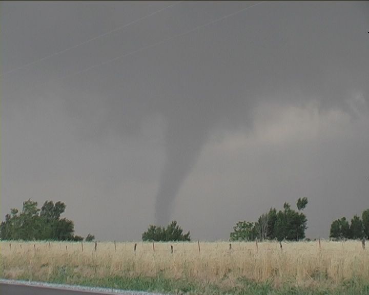
Now what happend next suprised me a little. A look at the SPC mesoanaylsis page did bring my hopes up since these cells were moving into an environment increasingly favorable for development. I remember an 8 indicies bullseye on the supercell composite parameter just east of these cells. (Way to go Rich!). Orignally I was just SE of the northernmost cell observing a very low and nice shelf when the NWS issued a tornado warning. BR1 still made the storm look dis-organized and weak but a look at a tilt of 19.5 showed 67dbz at 17,000 ft and a mid-level mesocyclone around Hatton, ND. As I jockeyed around trying to find this tornado the storm exploded and turned into a left mover. It was now clear the tornado was occuring on the left rear flank. About twenty minutes later the southernmost cell which had nearly died out, took on a hook echo and classic supercell charestics as it took a hard turn to the right of the wind vector. While the cells in the middle continued there journey eastward.

Left mover during tornado producing stage:


Velocity image on left rear flank of storm:


Forty minutes later after the left mover puts down three reported tornadoes and begins to weaken the right mover starts to really crank up and puts down a tornado of its own.


I never got a chance to check the offical NWS survey but it did end up in SPC storm reports orignally as reported. Any links to the survey are appreciated as well as discussions on how rare or how common anticyclonic tornadoes really are.
 
These things are pretty rare on the northern hemisphere, but do happen for unknown reasons, that are highly complex. I know that it has to do with a splitting supercell, that starts moving in the opposite direction, and then drops a tornado moving in the opposite direction. They are heard (near impossible) to detect on radar, but there must be some sort of signature of some nature, to look for.
 
These things are pretty rare on the northern hemisphere, but do happen for unknown reasons, that are highly complex. I know that it has to do with a splitting supercell, that starts moving in the opposite direction, and then drops a tornado moving in the opposite direction. They are heard (near impossible) to detect on radar, but there must be some sort of signature of some nature, to look for.

I'm don't think it's a case of "unknown reasons" -- I think there is a general understanding of how many anticyclonic tornadoes develop. They aren't common in the northern hemisphere, but that's mainly because of the wind profile that is usually associated with severe thunderstorms. If you have unstable conditions and a wind profile that backs with height, then you likely have an environment that is as conducive for anticyclonic supercells as it is for cyclonic supercells. Low-level warm air advection can often increase instability, which means, in the northern hemisphere, winds veer with height. So, many of the days that discrete convective development also often have veering wind profiles, which favor cyclonic rotation. There are times, however, when you have strong instability AND a wind profile that backs with height -- an environment that actually favors anticyclonic rotation. I've heard that this happens in southern California occassionally.

Straigh-line hodographs (those that have unidirectional shear, and it should be noted that veering wind profiles CAN still have unidirectional shear!) tend to characterize environments favorable for splitting supercells. In this case, there will be a cyclonic mesocyclone on the right side (of storm motion) and an anticyclonic mesocyclone on the left side (of storm motion). If conditions are otherwise favorable for tornadogenesis (of conditions which we currently think are favorable -- e.g. low LCLs, instability in the low-levels, etc) you could certainly get an anticyclonic tornado from the anticyclonic supercell.

As we all know, tornadoes aren't always associated with deep mesocyclones. Even with a cyclonic supercell, a more shallow anticylconic circulation center can develop along and south of the RFD. From what I recall, this was the method by which the May 29th, 2004, anticyclonic tornadoes near Calumet developed... Those tornadoes where located south of the cyclonic mesocyclone and along the southern leading edge of the RFD. A similar process has been noted by Dr. Wurman and observed with the DOWs on a storm in the Texas panhandle a couple of years ago.
 
Jeff already covered pretty much everything I know about the topic(I don't know much), but after looking at the archived data from that day, it looks like the left mover was from a storm split, which would have anticyclonic rotation. There was pretty good directional shear that day, but one thing I noticed was that the winds were relatively weak up to about 500mb where they became stronger and more westerly. I don't know how fast the left mover was moving, but after watching the radar loop it looks like it was moving pretty fast(maybe 30-35mph). This would be fast enough to create a storm relative shear profile that would favor anticyclonic rotation since the winds up to 700mb were <20kts. Perhaps this is why this left mover produced tornadoes when most don't.
There aren't a whole lot of anticyclonic tornadoes in the US because(as Jeff explained) warm air advection and increasing instability is associated with winds that veer with height(a clockwise curve on the hodograph) which causes cyclonic rotation. I would think that most anticyclonic tornadoes come from the left mover from a storm split and from an anticyclonic vortex associated with tilting of horizontal vorticity. Here is a link to some information on the topic.
http://www.weatherwise.org/qr/qry.anticyclone.html
 
These things are pretty rare on the northern hemisphere, but do happen for unknown reasons, that are highly complex. I know that it has to do with a splitting supercell, that starts moving in the opposite direction, and then drops a tornado moving in the opposite direction. They are heard (near impossible) to detect on radar, but there must be some sort of signature of some nature, to look for.

I'm don't think it's a case of "unknown reasons" -- I think there is a general understanding of how many anticyclonic tornadoes develop. They aren't common in the northern hemisphere, but that's mainly because of the wind profile that is usually associated with severe thunderstorms. If you have unstable conditions and a wind profile that backs with height, then you likely have an environment that is as conducive for anticyclonic supercells as it is for cyclonic supercells. Low-level warm air advection can often increase instability, which means, in the northern hemisphere, winds veer with height. So, many of the days that discrete convective development also often have veering wind profiles, which favor cyclonic rotation. There are times, however, when you have strong instability AND a wind profile that backs with height -- an environment that actually favors anticyclonic rotation. I've heard that this happens in southern California occassionally.

Straigh-line hodographs (those that have unidirectional shear, and it should be noted that veering wind profiles CAN still have unidirectional shear!) tend to characterize environments favorable for splitting supercells. In this case, there will be a cyclonic mesocyclone on the right side (of storm motion) and an anticyclonic mesocyclone on the left side (of storm motion). If conditions are otherwise favorable for tornadogenesis (of conditions which we currently think are favorable -- e.g. low LCLs, instability in the low-levels, etc) you could certainly get an anticyclonic tornado from the anticyclonic supercell.

As we all know, tornadoes aren't always associated with deep mesocyclones. Even with a cyclonic supercell, a more shallow anticylconic circulation center can develop along and south of the RFD. From what I recall, this was the method by which the May 29th, 2004, anticyclonic tornadoes near Calumet developed... Those tornadoes where located south of the cyclonic mesocyclone and along the southern leading edge of the RFD. A similar process has been noted by Dr. Wurman and observed with the DOWs on a storm in the Texas panhandle a couple of years ago.

Well, Jeff as you may be write I was simply stating that it maybe somewhat understood, but still, we don't understand how all happens. Do can take an item and spin it (what are those things called, you can spin), and it will show you, that when rotation is stronger it will move to the left, and when it weakens it will move to the left, right?
 
Several things stand out to me as to why the antisupercells rarely produce tornadoes. First, unless they are in NW low level flow the updraft pulling air from the left rear flank would not have as much low level storm releative inflow. Moisture could be a little less since it is drawing it north of the storm.
Also according to one study I read moving right against the typical severe weather wind profile (veering profile) provides more SRH than with the left movers. Seems that one common factor is rather weak flow through the lower and espically mid trophosphere.
 
Several things stand out to me as to why the antisupercells rarely produce tornadoes. First, unless they are in NW low level flow the updraft pulling air from the left rear flank would not have as much low level storm releative inflow. Moisture could be a little less since it is drawing it north of the storm.

Scott,
Cyclonically-rotating supercells benefit (or are driven by) a veering wind profile (which signifies warm-air advection in the northern hemisphere), while anticyclonically-rotating supercells benefit from (or are driven by) a backing wind profile (which signifies cold-air advection in the NH). To provide the best unimpeded inflow for an anticyclonic supercell, one would prefer northwesterly flow in the low-levels. As you noted, trajectories for such wind are often not from 'moisture-rich' regions in the NH.

Also according to one study I read moving right against the typical severe weather wind profile (veering profile) provides more SRH than with the left movers. Seems that one common factor is rather weak flow through the lower and espically mid trophosphere.

For a typical veering wind profile, a storm motion to the right of the mean flow usually increases SRH, while a motion to the left of the mean flow (all other things equal) tends to decrease SRH (or lead to net negative SRH). The opposite is true for a backing wind profile (cold-air advection regime) -- the magnitude of SRH will be greater for left-movers than for right-movers. Generally speaking, for left-movers in a veering wind profile environment, SRH is usually quite small compared to right-movers. In addition (though indirectly related to the magnitude of SRH), the local vorticity vector tends to be more normal to the storm-relative wind vector in the low-levels, which isn't desired if you're looking for tornadoes.
 
Thanks for your comments Jeff. I only wish I could have captured more video of this event as I was constantly playing catchup.
 
Wait a second at 22z around the time the storm was taking off it looks like some winds were being drawn in from the NW because an area of low pressure had just developed. Thus creating this profile backed with height and increasing inflow and probably bringing in better moisture thus providing a favorable therodynamic environment for this antisupercell.

 
Wait a second at 22z around the time the storm was taking off it looks like some winds were being drawn in from the NW because an area of low pressure had just developed. Thus creating this profile backed with height and increasing inflow and probably bringing in better moisture and as Jeff mentioned providing a favorable therodynamic environment for this antisupercell.

Scott,

The direction of the surface flow doesn't necessarily indicate CAA or WAA. You really should look at the change in wind direction with height. You can have northerly winds yet still be under a warm-air advection regime if you have a veering wind profile ("profile" indicating the winds though a vertical layer). For example, warm-air advection may be occurring if you have northerly surface flow, easterly flow at 1km, southerly flow at 2km, and southwesterly flow at 3km. For example, ff you look at areas immediately north of warm fronts, you'll usually see southeasterly, easterly, or northeasterly surface flow. Above the surface, however, you'll often see a strong veering wind profile -- indicating WAA. Of course, in most situations like this, a surface parcel will be strongly capped (given strong WAA immediately above the surface atop relatively cool, pre-warm-front air).

EDIT: Note that you'll sometimes see mid and upper-level winds that back with height, which can be a very good thing, since backing winds is evidence of CAA. If you warm the low-levels, and cool the mid-upper levels, you'll increase potential instability / decrease stability.)
 
Wait a second at 22z around the time the storm was taking off it looks like some winds were being drawn in from the NW because an area of low pressure had just developed. Thus creating this profile backed with height and increasing inflow and probably bringing in better moisture and as Jeff mentioned providing a favorable therodynamic environment for this antisupercell.

Scott,

The direction of the surface flow doesn't necessarily indicate CAA or WAA. You really should look at the change in wind direction with height. You can have northerly winds yet still be under a warm-air advection regime if you have a veering wind profile ("profile" indicating the winds though a vertical layer). For example, warm-air advection may be occurring if you have northerly surface flow, easterly flow at 1km, southerly flow at 2km, and southwesterly flow at 3km. For example, ff you look at areas immediately north of warm fronts, you'll usually see southeasterly, easterly, or northeasterly surface flow. Above the surface, however, you'll often see a strong veering wind profile -- indicating WAA. Of course, in most situations like this, a surface parcel will be strongly capped (given strong WAA immediately above the surface atop relatively cool, pre-warm-front air).


Yes, I understand that surface flow doesn't necessairly represent CAA or WAA regime. It's hard for me to tell how 850mb winds responded to this since it is several hours off and the nearest site is still some distance. I still believe that the development of an area of low pressure could have played a part in this. But I think its reasonable to assume that their was some depth to it or that it had some effect. I guess even with some depth the 700mb out of SW and 500mb out of W would have still resulted in a veering profile. But I would think that the developing low could serve to assist in at least low level inflow. Assuming their was some depth to the winds being drawn down from the NW wouldn't it be fair to assume that it could increase environmental helicity?

-Scott.
 
I have a hard time believing that developing low pressure on the front wouldn't have played a critical role since it is timed nearly perfectly, at least affected surface flow to increase 0-1km shear which would have been further increased based on the storms motion. I know that is a little assumptious since I have no way of assessing how much of the low level flow was affected but it seems to fit pretty right based on what transpired. But I don't think 850mb winds were coming out of the NW but rather im just suggesting on a mesoscale level that it probably played a part.
 
Scott,

I agree! I'm pretty sure the low did impact the convection; I didn't mean to imply that I don't think the low didn't have any effect.
 
Scott,

I agree! I'm pretty sure the low did impact the convection; I didn't mean to imply that I don't think the low didn't have any effect.

:D I really appreciate all your input. It really helps me understand why anticyclonic tornadoes are so rare.

-Scott.
 
Hi,

I know this is slightly off the main topic, but anti-cyclonic tornadoes were observed within the right movers on the perifery of the large mesocyclones 29th May 2004. I guess more leaning toward accessory tornadoes? This was observed on the northern Kansas supercell and also the beast that passed through Oklahoma!

http://www.australiasevereweather.com/stor...s/200405-03.htm

0529jd040.jpg


Regards,

Jimmy Deguara
 
Back
Top