Simone Lussardi
EF2
... for southern China.
Jet has come back once again in this unusually hot year, this time seems even more energic than last time, from the W-SW, with a trough of low pressure positioned in the right place for severe weather around here:
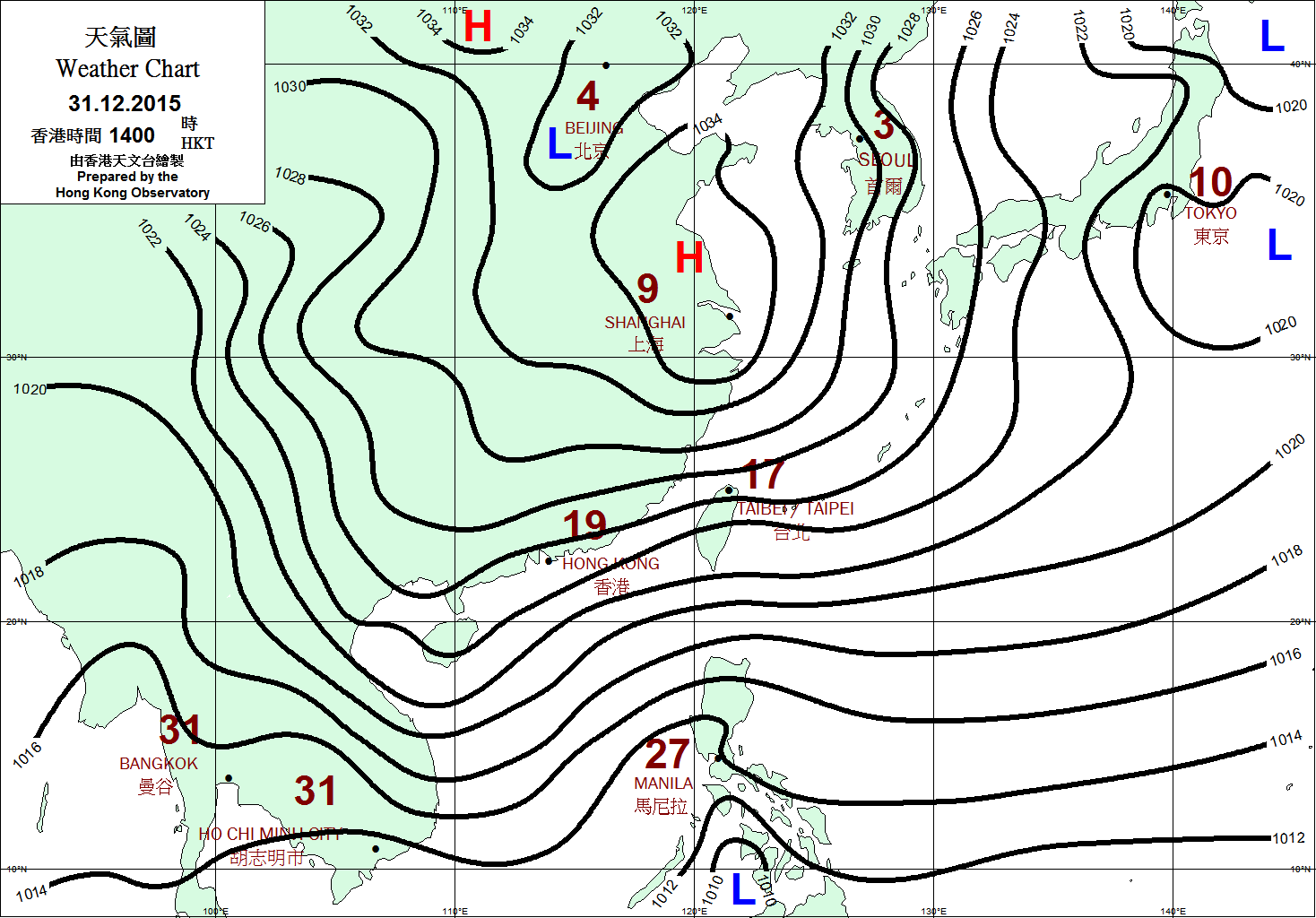
That deep surface trough will deepen even more and move southeastward toward the coast, enanching the sfc flow tonight. In the back sfc westerly winds from the hot central continent will drive some convergence. Plenty of juice in place:
Updated: 6:00 PM CST on May 23, 2005
Observed at Guangzhou, Guangdong (History)
Elevation: 26 ft / 8 m
84 °F / 29 °C
Partly Cloudy
Heat Index: 94 °F / 34 °C
Humidity: 79%
Dew Point: 77 °F / 25 °C
Some suspicious storm already bubbling:
[Broken External Image]:http://www.grmc.gov.cn/leida/gzradr/GZR200505230931.GIF
Loop:
http://www.grmc.gov.cn/tqsk/gzrad_r.asp
I'll keep you updated.
:wink:
Jet has come back once again in this unusually hot year, this time seems even more energic than last time, from the W-SW, with a trough of low pressure positioned in the right place for severe weather around here:
That deep surface trough will deepen even more and move southeastward toward the coast, enanching the sfc flow tonight. In the back sfc westerly winds from the hot central continent will drive some convergence. Plenty of juice in place:
Updated: 6:00 PM CST on May 23, 2005
Observed at Guangzhou, Guangdong (History)
Elevation: 26 ft / 8 m
84 °F / 29 °C
Partly Cloudy
Heat Index: 94 °F / 34 °C
Humidity: 79%
Dew Point: 77 °F / 25 °C
Some suspicious storm already bubbling:
[Broken External Image]:http://www.grmc.gov.cn/leida/gzradr/GZR200505230931.GIF
Loop:
http://www.grmc.gov.cn/tqsk/gzrad_r.asp
I'll keep you updated.
:wink:
 , but now is ok
  Thanks anyway for your test !! From the sounding get what I suspected: an over 40 kts s.westerly flow at 500 hpa coming toward the coast with the sfc trough.