A New Method for Collecting Tornado-Related Data

Balloon right into the inflow would be the mode. Smaller balloon with a reasonable light payload and some balancing via gyros, etc would deliver cameras and a radiosonde into an area of rotation. How long that balloon would survive for the instruments to do any good is questionable but the images derived from such a flight opportunity would be amazing I'd imagine.

I've considered a UAV and actually have a DJI Phantom 2+ that could act as a sacrificial lamb since I've recently upgraded. With my luck though, the silly thing would fall out of the sky or become a projectile and hurt someone.

Is your goal to take advantage of the updraft in the meso/tornado to gain altitude in order to measure the updraft wind speeds or other data? If you want to take measurements as the radiosonde drops, what type of data are you seeking to measure? In my project, I want to obtain measurements in the updraft at the lowest levels of the tornado. There have been many studies of at the mid- and upper levels of the storm. I want to see what's going on in the 0-2.5 km range. I really want to analyze a multiple vortex tornado. I've never considered taking measurements as the device drops through the storm, but I am intrigued by what data might be obtained by doing so.
 
If you have experience with probes that measure meteorological data, I sure could use your help. I'm designing a probe now and would appreciate any info on the subject. I have some knowledge of electronics and meteorology but by no means am I an expert.
 
Well, I have begun the process of attempting to obtain a special permit from the FAA to conduct research operations using UAVs. If obtained, the permit would be valid for a period of two years. There are numerous steps involved in getting a permit. I agree with most of their regulations, especially those regarding public safety, but some of their policies seem to be unnecessarily restrictive and heavy-handed. I've read most of their documentation, court rulings, and info regarding future attempts to revise their policies on UAVs for non-commercial research flights. It appears that it will take quite some time to get a permit, if one can be obtained at all. At least the process is underway. We shall see what happens...
 
If you want to construct it all yourself, I can give a tip to use SHT21 or SHT71 as an easy way to measure humidity and temperature.
 
As to many drones in the videos and photos? I'm sure PS will have a plugin or such to remove these, just as there's one to remove powerlines. Compared to the lines of cars parked barely off the shoulder, with car doors often open over the road, I think a few specs around a tornado would be moot.

I'd rather see drones in photos than the proverbial NSSL "strip of the horizon"...
 
If you want to construct it all yourself, I can give a tip to use SHT21 or SHT71 as an easy way to measure humidity and temperature.

Very affordable! The SHT21 cost only $5.00; the SHT71 costs around $28.00. I couldn't tell much difference in the specs for the two devices, except the 21 has 6 pins and the 71 has 4 pins. Unless I discover a major advantage of the 71 over the 21, I'll use the SHT21. The low cost is good news, since I'll be making at least 24 probes. Thanks for the info.
 
Very affordable! The SHT21 cost only $5.00; the SHT71 costs around $28.00. I couldn't tell much difference in the specs for the two devices, except the 21 has 6 pins and the 71 has 4 pins. Unless I discover a major advantage of the 71 over the 21, I'll use the SHT21. The low cost is good news, since I'll be making at least 24 probes. Thanks for the info.

The measurement specs are similar, yes. SHT21 is easier to interface with. The biggest difference is, SHT21 is surface mounted and not the easiest to solder. Surface mounting also means you need to take care to avoid heat coming from the PCB and offsetting the readings, and you need to make sure the sensor has good access to the flowing air. I do this by a custom FPC (flexible printed circuit) but those are somewhat expensive to manufacture. If you wish, I can sell you some of those assemblies and you can mount them via a connector. If so, contact me via email.
 
The measurement specs are similar, yes. SHT21 is easier to interface with. The biggest difference is, SHT21 is surface mounted and not the easiest to solder. Surface mounting also means you need to take care to avoid heat coming from the PCB and offsetting the readings, and you need to make sure the sensor has good access to the flowing air. I do this by a custom FPC (flexible printed circuit) but those are somewhat expensive to manufacture. If you wish, I can sell you some of those assemblies and you can mount them via a connector. If so, contact me via email.

Thanks. I will most likely be buying some from you. It will save me time, so it will be well worth it.
 
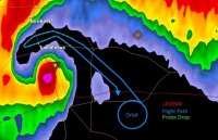
Progress report: I'm still researching several things, one of which is where to deploy probes, and at what intervals they should be deployed. One plan I'm considering is approaching the tornado in the inflow from the ESE (assuming the tornado is moving from SW to NE), and start probe deployment NNW of the tornado, where the winds should easily carry the probes up and into the vortex. This will be done at low altitude (approximately 300 feet), since my primary interest is to start the data-gathering process close to the ground. After deployment, I will make a 180 degree turn and return (upwind) the same way I came in.

I would appreciate your thoughts on this plan. I need input from those who are more knowledgeable than myself in the field of meteorology. I need all the info I can get.
 
Flight Path #1.jpg Here is a diagram of a possible flight path to deploy probes via inflow notch. Anybody see any potential problems with this flight path?
 
Last edited:
Anybody see any potential problems with this flight path?

All other issues aside, know that the part of the path where you plan to drop probes goes through the vault region, so you should expect/plan the flying device to encounter especially large hail.
 
All other issues aside, know that the part of the path where you plan to drop probes goes through the vault region, so you should expect/plan the flying device to encounter especially large hail.

Thanks, Jeff. That will force me to reconsider that particular plan. Perhaps dropping probes sooner to avoid the worst of the hail is an option. The inflow wind should still carry the probes to the desired locations.
 
So I highly recommend watching this video to get a sense of where to drop your "probes". This is a supercomputer simulation of the near storm environment presented at the AMS Severe Storms conference back in November, 2014. Skip ahead to 11:10 to see the parcel trajectories. Based on this it might be worth it to drop near the RFD boundary and have the probe fall and then get sucked back up near the base of the tornado or alternatively fly near the FFD/Inflow interface in front of the vault/bears cage. I totally agree though with Bart Comstock's post a few back though, if your gonna do this for real, talk with the researchers see what they want... and uh.. don't expect your plane to survive.

 
Last edited:
Back
Top