9/22/2006 REPORTS: IL / MO / AR / KY / TN / IN

John Farley

Supporter
Joined
Apr 1, 2004
Messages
1,828
Location
Pagosa Springs, CO
Well . . .

Now that the board is up and running again - thanks for all your hard work, Tim and other mods who have been addressing the problems - let's get a thread started for Friday's reports.

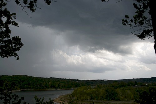
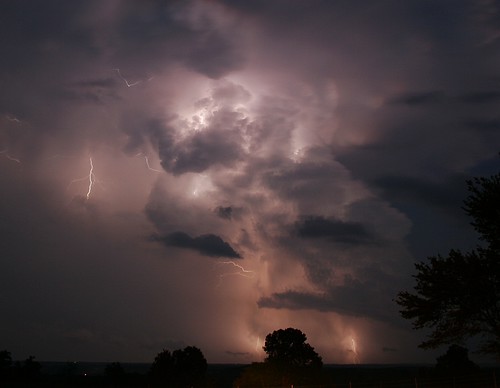
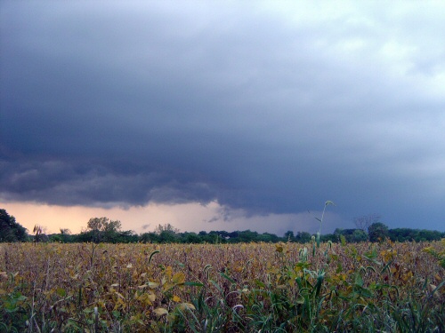
I intercepted 3 tornado-warned storms in Monroe Co., IL, but, alas, none of them produced. :mad: I had thought about heading down I-44 into MO, but with the storms moving 50 mph through the terrible chase terrain in that area, I opted to try to intercept when they crossed the Mississippi River.

Despite the lack of tornadoes, I got a few decent pics, and had an OK chase considering the difficulty of the situation. :cool: Congrats to Dan Robinson and all others who scored on this challenging day.

Full chase report with pictures here:

http://www.siue.edu/~jfarley/chase92206.htm

You can also access all of my other chase reports, including the one from the 11th that got hosed in the server crash, from my Weather Observations Page:

http://www.siue.edu/~jfarley/wxobs.htm
 
New Rule:

When there is a PDS box out, STOP ALL ROAD CONSTRUCTION FLAG-MAN ROAD CLOSURES
!!!!

I flew into St.Louis and teamed up with Brad Riley and hurried onto I-44 to blast south-west. We got on the St.James cell early on and surprisingly were able to keep up with it when all of a sudden we spot a menacing looking wall cloud, BAM, of course now we hit road construction and road closures on 63. We actually HAD to go into the hail to get onto another road option to get east and catch back up with it. Once we made it through the baseballs and after loosing our windshield we spot the Tornado. It was a fat white cone and once the camera came out and we could see the area where it was without tree's in the way it was Gone ! Damn, we just missed it ! We got road screwed ! We would have witnessed the entire life of the St.James tornado (Phelps County) if it was not for flag man ! Now this opens up a new topic. Not only for chasers sake but for the general public. When a PDS box is issued anything that is going to cause traffic jams should be disabled until the threat is gone! The meso and maybe the developing tornado must have went right over the traffic jam and flag man we were avoiding.

Mike Theiss
UltimateChase.com
 
[FONT=Courier New, Courier]
sept22c.jpg
[/FONT]

Tom Mullins and I witnessed a wedge tornado on Highway 3 in southern Illinois on Friday, about 15 miles west of the town of Murphysboro. We estimated our closest approach to the tornado and its subsequent crossing of Illinois Highway 3 in front of us was less than a mile. As the tornado crossed the road in front of us, a shower of various debris rained down around us, including large strips of sheet metal, small branches and small bits of plywood. Twigs and small branches with leaves landed on us, and shredded leaves clung to our windshield. We first viewed the tornado from due north.

When we first caught sight of the tornado, it was near the Crosstown/Menfro area across the river in Missouri. Preliminary surveys are indicating possible F4 damage in Crosstown.

Full report with video clip and images is here:

[URL]http://wvlightning.com/sept222006.shtml[/URL]
 
Last edited by a moderator:
Left Tulsa shortly before 2 pm then got hung up in Springdale,AR. traffic (imagine that) . Played catch up with most storms and others it was peekaboo over the hills and trees. I did find one good vantage point in War Eagle campgrounds.
251782259_50f8136481.jpg


and another spot east of Harrison,AR to watch this tornado warned cell
251798069_85b8edd3be.jpg


Other pictures from NC Arkansas are here

After working my way back west on hwy 62 to Rogers,AR. I headed into EC Oklahoma to catch the storms coming up from the Eufala Lake area but didn't make it . From Tahleguah I headed back towards home and finished the morning watching the last storms fire up around Tulsa.
Finally getting home around 5 am after 15 hours & 400 plus miles
 
Last edited by a moderator:
A rather disappointing bust for a big setup. I met up with Scott Weberpal in Collinsville, IL and decided against intercepting in Missouri. Instead, based on the RUC breaking precip out over central IL and SPC’s MD for central IL, I waited for new action across the river. Small, yet unimpressive multicellular clusters were firing up near Springfield, and three supercells, the northern one dieing quickly, were passing south of St. Louis. Opting out of what looked like a messy core punch over terrible terrain, we went north and didn’t make it to the Jacksonville area in time to catch the briefly tornado warned cells. Intercepted in Petersburg witnessing a scuddy, storm as it gusted out. Oh well, it was nice to get out there again after several months of being trapped behind work and school.


sep22.jpg
 
Eric Perozo and I left Jackson Thursday evening and stayed in West Memphis, Ar. We got up that morning and slept just and hour from are target of Jonesboro, Ar. We were on tornado warned storms all day long and I have to say that we did an excellent job of chasing. At no time did we have to punch a core, at no time we took the wrong road option, we stayed in great position to all the storms but they just did not produce. We did see wall clouds all day long and even saw a funnel that was reported as a tornado but neither of us could tell if it ever touched down because of the distance and the trees. Overall it was a fun chase day but also dissapointing. My theory is that the storms were just too HP in characteristic to produce. The wall clouds would form suddenly, rotate violently then just as quickly as they would appear the RFD or rain/hail shaft would gobble them up. The lightning was insane, I have never seen so much lightning. Overall I think we were on 9 tornado warned storms, 2 of which "supposedly produced". Eric got some great photos, hopefully he will find the time to post them. Congrats to Dan on the wedge, man that looks like a great storm!
 
Western Arkansas Chase

I chased locally since storms were forecast to fire anywhere acorss Eastern Ok and Western ARK at pretty much anytime. The first storms i saw formed within 15 miles of my house near Ozark, AR around noon and they slowly organized but I didnt follow as they were already east of me and heading into the mtns...they did go tornado warned at 130 over north central ark. Then i had a hour break back at home until some storms began firing in Eastern Oklahoma. The road options as some of you know are extremely bad with not too many W-E roads so I was limited to what i could do. I decided to take it slow and head straight North on HWY 23 to have a intercept of the storm near St.Paul. Everything worked perfectly for once in the mountains and i got to st.paul right as the storm did and saw a wondefull wall cloud. The storm motions were not anything close to tornadic but still it was nice.
IMG_1174x.JPG


Soon after above pic was taken the wall cloud dissipated rapidly. The next storm came through around 6pm and was just slightly futher south of the previous one. It too had a nice wall cloud..
IMG_1217x.JPG


but as with the first one it dissipated pretty quickly. All in all not too bad of a chase so close to home. I saw 3 seperate nice tornado warned storms that all 3 went on to become much more organized towards north central arkansas.

more pics at http://www.realclearwx.com/9232006.htm
and previous days chase at http://www.realclearwx.com/92206.htm
 
Last edited by a moderator:
This trip convinced me that I’ve got to get an aircard. Wi-fi is just too limiting, and I made one poor decision because I couldn’t get online and access radar when I needed to.

That being said, I still managed to witness a funnel cloud and possible brief tornado when I intercepted a line of cells to the west and northwest of Springfield, Illinois. These storms were training in a northeasterly direction; they were quite small compared the man-eaters in Missouri and southern Illinois, but as I approached the cell nearest me on state road 97 a little way past Bradfordton, I noticed a rain shaft and a ragged rain-free base with a funnel poking out of it. By the time I pulled over and got my camcorder rolling the funnel had dissipated, but as I filmed the updraft area, a block of cloud consolidated in the middle of it and offered about forty-five seconds worth of what I think was a stout stovepipe tornado. I can’t say this with complete certainty because it was a couple miles away and I couldn’t make out any definite motion, and with tall corn in the foreground and a treeline not far away, I couldn’t tell whether the column extended all the way to the ground. Still, it was pretty well-defined and looked convincing enough that if it wasn’t a tornado, it was doing a darned good impression of one.

Now for the ultimate bite in the butt: Saturday, as I was making my way back home through the grunge in Indiana, a small tornado passed through my small hometown of Caledonia just a few hundred yards from my apartment. Had I been home, I could have stepped out onto my balcony and watched it go through. The funnel tore up a golf cart business along M-37 and trashed the farm to its north. And yesterday, when I went to film the damage, I accidentally recorded over the footage I'd taken in Illinois.

There are ironies in life that words just can’t capture. I’m not sure whether to laugh or cry about this one. Ahhh, what the heck…might as well laugh.
 
Last edited by a moderator:
A very exciting day for us, as my chasing partner Jeremy and I captured our first tornado. It was rather weak and was only on the ground for a very brief time, but nevertheless we were very excited. Luckily it was out over open farmfield.

We intercepted a pair of two rather small cells near Delavan IL around 5pm. After driving through part of the eastern cell, we noticed the cell to the west showing a nice rain free base, with a long inflow tail to the southeast. As we approached it, around 5:15 we noticed a small, yet distinct tornado a few miles to the west of us underneath the base. At this point we were probably a few miles west of Delavan. As soon as it appeared it was gone again. I missed the opportunity with my camera, but got it all on Hi-8 video tape (which we will be converting to dvd shortly).

Here's the cell as we approached it from the east near Delavan.

 
9/22 Ark. chase

Glad to see the ST Boards up again... and me being able to post once again.!
______________________________________________________________

Charles Edwards and I took off from Shawnee at aprox. 0830 with a good feeling about this day... I could'nt believe the set up for this time of year and this coincided with me having a few extra bucks and time to chase... did'nt care if it was in Arkansas or Missouri. My target was Fayetteville and on up into SW. MO. I liked the rush of low 70's dews northward, helicity values of over 450 m/s and the fact that the atmosphere was already clearing out providing for adequate destabilization. We initially headed up for Tulsa with eyes set on Joplin and possibly south to Fayetteville but Gene Rhoden kindly conveyed an update which had me thinking about my original idea of the I-40 corridor, so we bounced back down the Muskogee Tpk and east on 40 we rolled. .. capes were in the 4K j/g range just north of Little Rock by 17Z... we reached the Altus area (Ark.) exit 35 on I-40 at about 17Z... congestus all quads progressed into explosive cumulonimbi especially just below us south of Ozark and Altus

A non severe cell crossed I-40 at about 1720gmt. the base exhibited a pronounced clear slot to its south and you could tell there was some mid level rotation.. we crossed the path where the cell crossed with nothing out of the ordinary... no hail, no damage. We went up north out of Conway toward Marshall by about 19Z... our main storm that we intercepted earlier had turned into an intense TOR warned supercell that was still visible as it tore thru Boone and Marion Co. Ark. the skies exhibited more of a stable look for awhile as Cu were flatter and less dense as we came into Conway... I'm thinking a temporary period of sinking air behind that first cell (??) We went north on Hwy 65 out of Conway and stopped in Marshall where the winds increased to about 20-30kts from the south, clouds once again had a congestus look and you can tell the low level shear was increasing as turkey towers exhibited a strong twisting tilt to the east/northeast. Then we intercepted our next cell which was up Hwy 65 near St. Jo in far northern Searcy Co. the cell had a great solid crisp anvil as it quickly closed in... thanks to Dave Ewldt's advice, we backtracked and went back thru Marshall to Hwy 27, we got a brief but good look at the base which was clearly a strong meso with low ragged wall cloud... anvil to ground CG's were intense as we tried keeping up with this thru winding hilly tree covered terrain...the times were roughly around 22Z... a couple of times the wallcloud looked promising... good structure but very little if any rotation at the base... we eventually let that go when another cell came up on Ash Flat in northern Sharp Co. by sundown... it was becoming dark and I was not about to chase in this kind of terrain in the dark... so Charles and I had dinner in Ash Flat as a fierce lightning show ensued with plenty of staccato bolts but not much rain or wind. We later found out we were dead centre in a TOR warning as a TOR was either sighted or was indicated on radar right over us... turned out thismorning (9/23) that there was high end F0 MAYBE low end F1 damage about 5mi. south of Ash Flat (aprox.)

We decided to stay the night in Cherokee Village in far northern Sharp Co. and we were treated to one cell after another training over our area... Charles was sawing logs while I laid in bed waiting for my hair to stand on end from the constant bombardment of very close lightning bolts that went on for hours... radar estimates thismorning from LIT and MEM sites had between 10-15in. don't think it was that much but I would think 6" is a good bet... roads were all passable but a few streams we passed by were raging torrents. On the way home, Charles Edwards and I were treated to a great lunch from Jason Politte and Karen Leszke..it was great seeing them again and much appreciation for their hospitality!

So.... again my tornadoless streak continues but had a great time, incredible storms and for a system like this for this time of year... it was a real treat to chase.

Thanks to Gene Rhoden, Bobby Prentice and Dave Ewoldt for the nowcasting.... and Charles Edwards and is ingenuity that provided us with data this time!!! Congrats to all who were able to at least chase... looking forward to some great discussions on this historic day.

Big Blessings! Rocky&family
 
Ah, finally the board is back and I can post my chase report for this exciting day. What could be better than an outbreak of warmfront juxtaposed supercells in the Chicago Metro on an autumn afternoon. I headed out from the NIU campus shortly after 3pm. I shot south along Peace Road (parallels IL 23), then slightly west before I turned onto a few dirt roads across farmland. I watched a small group of rather un-interesting cumulus transform into a very strong thunderstorm, literally before my eyes. As I approached the rear of the storm from the north, there was a constant crackling rumble of thunder. This thing was a living, breathing beast. The precip core was black and green. To the southwest, there was a very low hanging area of scud that soon attached to the cloud base. I saw a few distant funnels dancing around the lowering. The precip core moved toward me, and I went towards the lowering under moderate rain and wild CG's. I reached the lowering and it looked rather unimpressive. Little did I know, it would become much better oragnized and rotate it's way toward the northern metro area, tornado warned the whole way.

I noticed a new updraft to the west a little. It was pretty far away, but with the speedy way these things were moving, distance wasn't much of an issue. As I approached it from the southeast, there were intense and very frequent CG's. This storm had a better organized rain-free base, but there was no real sign of any rotation or RFD. By this time I was in eastern Lee county, near Amboy, IL. I noticed a new lowering to the west, but this one quickly gusted out, and I got caught. Within seconds, I was engulfed by penny hail, astronomically heavy rainfall (I've never seen it rain so hard!), and according to the LSR, 72 mph winds!:eek: Small branches and penny hail were slamming into my car, I'm glad no damage was done. My mom called me from Schaumburg, and said the tornado sirens were blowing for 20 minutes, and the police jumped on EAS with a tornado sighting. I said I had problems of my own, lol. I also kicked myself for not staying on that storm. As the storm passed, it became nearly cloudless and brightly sunlit. A bright rainbow formed to my east, and it was rather persistent; lasting til nearly sunset!:eek: It had to be the longest lived rainbow I have ever observed. I went south to look for an eastern option to follow the cells. I was able to find one near Shabonna, IL. By this time they were racing away rapidly. I could see the flanking line extending south and west, with lots of inflow features. There were many suspicious lowerings. The best feature was the hailcore to the northeast with the brilliant rainbow! I noticed some storm damage as I followed the cells, mainly from straight line winds and some microbursts. I was told at a gas station that i missed two touchdowns near I-88 and Hinckley, but this has not been confirmed by anyone. Nonetheless, It was a fun chase, even with the risky inadvertent core-punch. I guess the convective deflector shut down for a while. LOL.:cool:

pics: http://s10.photobucket.com/albums/a101/sgtdave2316/storm chase sep22 23/
 
Chase Account And Full Log (Chris C)

Good day everyone,

Finally got my chase log up for 9-22-2006...

I am glad to say I can post now, and thanks to Tim's dedication and hard work this system is back up and I am delighted with the performance - Good job!

Anyway, I got my full chase log for the Missouri storms on Friday, September 22, 2006 up and running on my side. My main link is below for you to browse and enjoy!

http://www.sky-chaser.com/mwcl06c.htm

You can also view a couple of pictures I have below...

moscel3.jpg


Supercell storm at dusk, near Hillsboro, MO on 9-22-2006.

motor4.jpg


Developing tornado approaching Saint James, Missouri on 9-22-2006.

motdam1.jpg


Some damage in Saint James to a gas station (poor quality from video), but note tornado in background!

motor3.jpg


Another developing tornado north of Madison County and east of Highway 67.
 
Today was a rather frustrating day for me.

We didn't leave KC untill 12:30 and we could already see a nice cell rapidly devloping to our southeast we quickly checked data and saw a tornado-warning was issued and a PDS tornado watch. We tried to get in front of the now amazing cells blasting away from us, but we didn't give up. We arrived in Rolla and saw a new area of convection to our south so after enduring the mountainous terrian we found a good spot to setup and watch three developing cells.
Then the northern storm then exploded and an amazing structured storm was on our hands. We could see an ominous lowering through the trees so we found a dirt round and found an open spot on the top of a hill. To our dismay we saw a possible tornado on the ground. We are 95% sure it was. Then the storm quickly weakened and we ended the day in Rolla.

All in all not great but not as good as what we saw the weekend before.

Here are some pictures
http://s84.photobucket.com/albums/k3/wolverines028/September%2022/?sc=1&addtype=local
 
Back
Top