John Erwin
EF5
**rescued post**
Scott Olson
Moderator
Location: Brookings, South Dakota
Posted: Thu Aug 24, 2006 8:07 pm
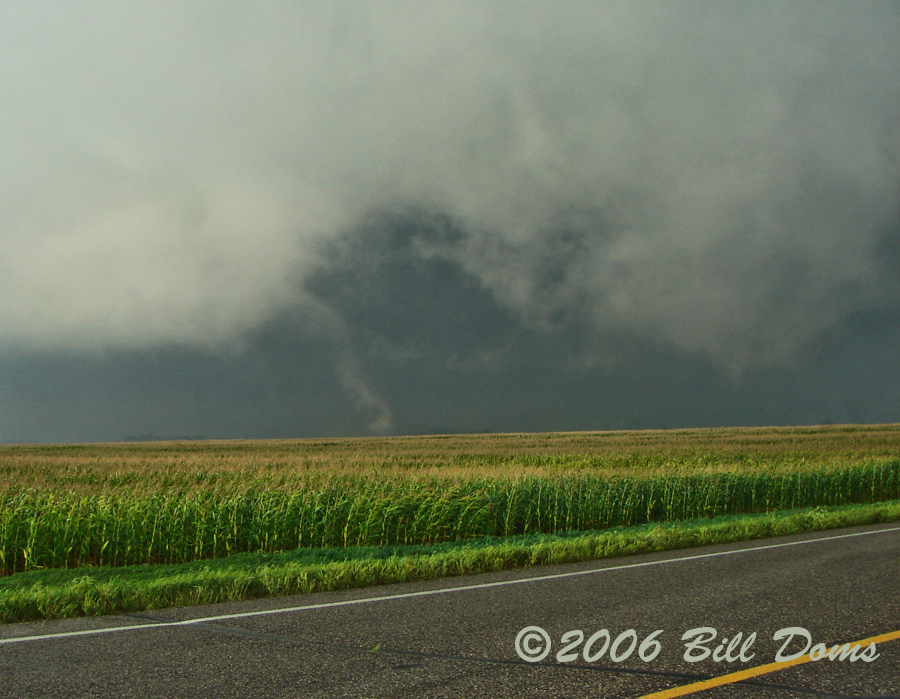
Incredible chase day, to say the least. During the day the cloud cover had burnt off from west to east. Convection had begun forming on the cold front with to much CINH and only weak moisture convergence along the WF in Eastern SD. I quickly headed out west and came up on the tornadic supercell on the entrance to highway 14 (15 NW of Huron). Tornadoes 2-5 are near Wessington.
Tornado 1: A tall fully extended tube was already visible. This was witnessed for about 2-3 minutes before it became rain-wrapped. I pushed on east, to about 3 mi west of Wessington. Here it re-emerged and was visible for several more minutes, then quickly dissipated.
Tornado 2: Formed to the right within a minute. Brief
Tornado 3: Beleive this one lasted a couple minutes with a good ground circulation.
Tornado 4: I believe this was a tube then a cone. I think this was the tornado that went through the S part of Wessington. This tornado was about 1 mile away at closest and appeared to have a very intense circulation.
Tornado 5: Lasted a couple minutes, good amount of debris.
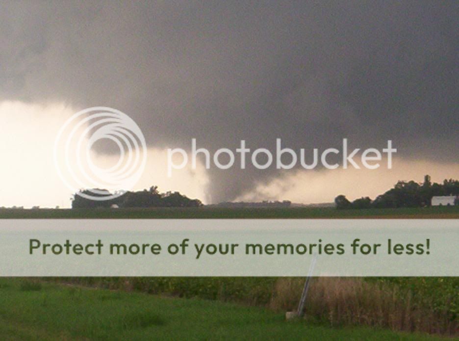
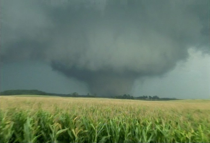
Tornado 6: Believe this started as a tube, strong ground circulation. This tornado steadly grew into a large cone (1/4 mile). As I neared Wosley the dirt/debris grew very large, to the point where it appeared to be a large wedge. Not really sure if the tornado actually expanded or if this was from the intense winds or debris/dirt falling around the tornado. In Wosley I witnessed I saw a firefighter in the road screaming "It was a mile away, last chance!". It was really close and getting larger at this point and at the worst moment the south of town had a train go through. I went QUICKLY west towards the tornado in order to safely get across the next road before the train blocked all traffic. I truly hope no one got stuck south of the shelter. As I got south of Wolsey the tornado was about 1 mile away.
Continued south until I got to turn east on highway 14. The tornado still appeared huge and strong in fact I think this is when it got it's biggest somewhere near the time it hit Wolsey. It intermittently went from a large 1/4 tube to nearly a mile of dirt and debris.
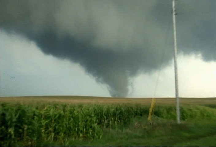
I decided to go into Huron and head south, in order to stay in a good chase position (it was heading SE at the time). As I was Huron I could see the cone re-emerge 2-3miles to my west. I headed south from Huron for several miles. This is when a beautifully stretched rope tornado moved across the highway (about 2-4 mi S of Huron). Im pretty sure this was from the wedge. It was dissipating as it moved over the highway and thinned and stretched considerably. This tornado lasted nearly 30-40 minutes.
Tornado 7: I continued east on dirt roads trying to keep up with the cell. I had fallen behind a couple miles and needed to get back up ahead. About 20-30 minutes from the previous tornado, I observed a new tornado a nice sunlit white rope tornado that formed about 10 ESE of Huron. Im not sure if this tornado was already there or had just formed, but it lasted about 3-4 minutes. I think this was during the time of the Carvour tornado and this tornado seemed to form in the anticyclonic vorticity region & I thought the next radar update showed a little anticyclonic flare on the hook. Not positive though but I will confirm this later.
It was an incredible day, certainly the most powerful supercell I have witnessed. The sheer strength and definition of the inflow bands were impressive. The RFD was intense throwing up dirt towards the clouds all around the area.
Josh Richardson
Location: Mason City IA
Posted: Thu Aug 24, 2006 8:29 pm
Decided to change the target area after getting to Blue Earth and headed for Mankato while heading there my chase partner(Jayson Prentice) and I decided to move a little further west towards some CU building near Madelia south of the New Ulm area. After getting gas the towers shot up extremely fast and within about ten minutes it went TOR warned and had a very nice meso on it. We shot up to HWY 68 west of Judson where we could see a great looking wall cloud rotating and moving NE across the river there as we continued west towards we got a glimpse of the tornado touchdown across the river near Nicolette and then rope out again after dealing with more trees due to the river valley we again seen the tornado in a stovepipe form and looking rather large near Nicolette at this point we then had to head north towards it across the river and lost sight again due to all the trees. After getting to Nicolette we witnessed plenty of downed power lines and structural damage especially on the north east side of town and outside of town to the east. While trying to maneuver a horrible road network and damage and police all over the place we continued to stay behind the tornado which appeared to be rain wrapped at this time continously running across more damage. Meso still looked great from behind the entire way to St. Peter but were unsure if tornado was on the ground the entire time as it seemed to be lifting and dropping quite frequently. In St. Peter we cam across more structural damage and downed power lines in the road on the SE side of town. We had to have only still been a couple of minutes behind it at that point as there were no cops there yet and everyone had to drive around the power poles and over the lines. After that we ran into more and more bad road networks and zig-zagged SE for a long while and didnt really get any more great structure. All in all though I think I covered everything but Im sure Jayson can note something if I forgot. At least now Im not shutout for the year!! Will try to get vid stills up on here this weekend although never had a chance to pullover to get anything good as we were constantly on the move to find a better road system or to avoid power lines and other debris. So Im not sure how well the contrast was on the stovepipe vid grab will have to check it out later.
ashleyallen
Location: Madison, SD
Posted:Thu Aug 24, 2006 9:58 pm
Beadle and Kingsbury County, SD
I booked it all the way back from Minnesota with my chase partner Kory Hartman. We made it to Cavour (East of Mitchell 10 miles on HWY 14), and saw the large rope tornado south of Huron. I was south of Cavour about 7 Miles on 409th Ave. We stopped to videotape the large wedge tornado that went through the south side of Cavour. Homes damaged and a couple people taken to the hospital according to Minor County Sheriff reports. It became rain wrapped and we lost visual. Later, another rope tornado formed (or could have been same wedge tornado) between Cavour and Iroqouis. There is some damage and it looks like our CBS affiliate Kelo TV will be covering it tomorrow. We met up with the storm team from Keloland TV and followed the wall cloud with heavy rotation all the way to Carthage. Had a chance to meet Famous Chaser Roger Hill tonight, he was right behind us in Beadle County for a while.
As I said before, start in Kingsbury county and go from there. I made the mistake of going to Minnesota on a heading towards New Ulm, but decided to turn around at 6 PM and made it back to Huron just in time to see 3 different tornadoes tonight. Very unreal experience, but very sobering and sad when I saw the wedge go through Cavour. I hope everyone is fine and there is not much damage. Tomorrow will tell the whole story.
I will have some video edited up in the next few days. If you are interested, please email me.
Goodnight everyone.
Ashley Kenneth Allen
Melanie Metz
Location: Minnesota
Posted: Thu Aug 24, 2006 10:45 pm
What a day in MN! Peggy and I arrived at our target right on time. We are sad to see the damage done but luckily we were able to report live on-air from the field to help warn those in the surrounding area.
MORE IMAGES AT:
http://www.twistersisters.com/082406.htm
VIDEO CLIP (wmv file ~12M:
http://www.twistersisters.com/082406_MN_Tornado_2.wmv


Mel & Peggy & Brad & Bill & Cullen
Scott Olson
Moderator
Location: Brookings, South Dakota
Posted: Thu Aug 24, 2006 8:07 pm
Incredible chase day, to say the least. During the day the cloud cover had burnt off from west to east. Convection had begun forming on the cold front with to much CINH and only weak moisture convergence along the WF in Eastern SD. I quickly headed out west and came up on the tornadic supercell on the entrance to highway 14 (15 NW of Huron). Tornadoes 2-5 are near Wessington.
Tornado 1: A tall fully extended tube was already visible. This was witnessed for about 2-3 minutes before it became rain-wrapped. I pushed on east, to about 3 mi west of Wessington. Here it re-emerged and was visible for several more minutes, then quickly dissipated.
Tornado 2: Formed to the right within a minute. Brief
Tornado 3: Beleive this one lasted a couple minutes with a good ground circulation.
Tornado 4: I believe this was a tube then a cone. I think this was the tornado that went through the S part of Wessington. This tornado was about 1 mile away at closest and appeared to have a very intense circulation.
Tornado 5: Lasted a couple minutes, good amount of debris.
Tornado 6: Believe this started as a tube, strong ground circulation. This tornado steadly grew into a large cone (1/4 mile). As I neared Wosley the dirt/debris grew very large, to the point where it appeared to be a large wedge. Not really sure if the tornado actually expanded or if this was from the intense winds or debris/dirt falling around the tornado. In Wosley I witnessed I saw a firefighter in the road screaming "It was a mile away, last chance!". It was really close and getting larger at this point and at the worst moment the south of town had a train go through. I went QUICKLY west towards the tornado in order to safely get across the next road before the train blocked all traffic. I truly hope no one got stuck south of the shelter. As I got south of Wolsey the tornado was about 1 mile away.
Continued south until I got to turn east on highway 14. The tornado still appeared huge and strong in fact I think this is when it got it's biggest somewhere near the time it hit Wolsey. It intermittently went from a large 1/4 tube to nearly a mile of dirt and debris.
I decided to go into Huron and head south, in order to stay in a good chase position (it was heading SE at the time). As I was Huron I could see the cone re-emerge 2-3miles to my west. I headed south from Huron for several miles. This is when a beautifully stretched rope tornado moved across the highway (about 2-4 mi S of Huron). Im pretty sure this was from the wedge. It was dissipating as it moved over the highway and thinned and stretched considerably. This tornado lasted nearly 30-40 minutes.
Tornado 7: I continued east on dirt roads trying to keep up with the cell. I had fallen behind a couple miles and needed to get back up ahead. About 20-30 minutes from the previous tornado, I observed a new tornado a nice sunlit white rope tornado that formed about 10 ESE of Huron. Im not sure if this tornado was already there or had just formed, but it lasted about 3-4 minutes. I think this was during the time of the Carvour tornado and this tornado seemed to form in the anticyclonic vorticity region & I thought the next radar update showed a little anticyclonic flare on the hook. Not positive though but I will confirm this later.
It was an incredible day, certainly the most powerful supercell I have witnessed. The sheer strength and definition of the inflow bands were impressive. The RFD was intense throwing up dirt towards the clouds all around the area.
Josh Richardson
Location: Mason City IA
Posted: Thu Aug 24, 2006 8:29 pm
Decided to change the target area after getting to Blue Earth and headed for Mankato while heading there my chase partner(Jayson Prentice) and I decided to move a little further west towards some CU building near Madelia south of the New Ulm area. After getting gas the towers shot up extremely fast and within about ten minutes it went TOR warned and had a very nice meso on it. We shot up to HWY 68 west of Judson where we could see a great looking wall cloud rotating and moving NE across the river there as we continued west towards we got a glimpse of the tornado touchdown across the river near Nicolette and then rope out again after dealing with more trees due to the river valley we again seen the tornado in a stovepipe form and looking rather large near Nicolette at this point we then had to head north towards it across the river and lost sight again due to all the trees. After getting to Nicolette we witnessed plenty of downed power lines and structural damage especially on the north east side of town and outside of town to the east. While trying to maneuver a horrible road network and damage and police all over the place we continued to stay behind the tornado which appeared to be rain wrapped at this time continously running across more damage. Meso still looked great from behind the entire way to St. Peter but were unsure if tornado was on the ground the entire time as it seemed to be lifting and dropping quite frequently. In St. Peter we cam across more structural damage and downed power lines in the road on the SE side of town. We had to have only still been a couple of minutes behind it at that point as there were no cops there yet and everyone had to drive around the power poles and over the lines. After that we ran into more and more bad road networks and zig-zagged SE for a long while and didnt really get any more great structure. All in all though I think I covered everything but Im sure Jayson can note something if I forgot. At least now Im not shutout for the year!! Will try to get vid stills up on here this weekend although never had a chance to pullover to get anything good as we were constantly on the move to find a better road system or to avoid power lines and other debris. So Im not sure how well the contrast was on the stovepipe vid grab will have to check it out later.
ashleyallen
Location: Madison, SD
Posted:Thu Aug 24, 2006 9:58 pm
Beadle and Kingsbury County, SD
I booked it all the way back from Minnesota with my chase partner Kory Hartman. We made it to Cavour (East of Mitchell 10 miles on HWY 14), and saw the large rope tornado south of Huron. I was south of Cavour about 7 Miles on 409th Ave. We stopped to videotape the large wedge tornado that went through the south side of Cavour. Homes damaged and a couple people taken to the hospital according to Minor County Sheriff reports. It became rain wrapped and we lost visual. Later, another rope tornado formed (or could have been same wedge tornado) between Cavour and Iroqouis. There is some damage and it looks like our CBS affiliate Kelo TV will be covering it tomorrow. We met up with the storm team from Keloland TV and followed the wall cloud with heavy rotation all the way to Carthage. Had a chance to meet Famous Chaser Roger Hill tonight, he was right behind us in Beadle County for a while.
As I said before, start in Kingsbury county and go from there. I made the mistake of going to Minnesota on a heading towards New Ulm, but decided to turn around at 6 PM and made it back to Huron just in time to see 3 different tornadoes tonight. Very unreal experience, but very sobering and sad when I saw the wedge go through Cavour. I hope everyone is fine and there is not much damage. Tomorrow will tell the whole story.
I will have some video edited up in the next few days. If you are interested, please email me.
Goodnight everyone.
Ashley Kenneth Allen
Melanie Metz
Location: Minnesota
Posted: Thu Aug 24, 2006 10:45 pm
What a day in MN! Peggy and I arrived at our target right on time. We are sad to see the damage done but luckily we were able to report live on-air from the field to help warn those in the surrounding area.
MORE IMAGES AT:
http://www.twistersisters.com/082406.htm
VIDEO CLIP (wmv file ~12M:
http://www.twistersisters.com/082406_MN_Tornado_2.wmv
Mel & Peggy & Brad & Bill & Cullen
Last edited by a moderator: