7/19/06 REPORTS: IA/IL/MN/WI/MO

John Farley

Supporter
Joined
Apr 1, 2004
Messages
1,828
Location
Pagosa Springs, CO
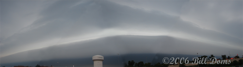
I saw what MAY have been a tornado or funnel cloud today while storm-chasing near the north edge of Springfield, IL. Or more like being chased, the way those storms were moving. Anyway, a minute or two after ILX issued a TOR warning for Springfield, I noticed a dark column extending toward the ground off to my southeast, probably a mile or two away. It was somewhat diagonal, not straight down, with the top to the SW of the lower end. My location at the time was on route 29 just south of route 124, near the north edge of Springfield. Minutes earlier, spotters had reported a tornado about 3 miles north of where I was, moving southeast. I had just turned south on 29 when the warning came over the weather radio, and I saw the column within a minute or so of hearing the warning. I could only see it for about a minute, and could not tell for sure what it was - looked like it could have been either a cloud lowering or smoke - though it disappeared after about a minute. One reason I could not tell for sure what it was is that I was looking through rain curtains just ahead of me that were surging to the southwest - and also had to concentrate on driving in the lousy conditions. Hence, no photos or video. And no way to see whether or not it was rotating. However, it was along the path of the meso, as the next NWS statement 5-10 minutes later reported rotation indicated by radar a few miles southeast of where I saw the column

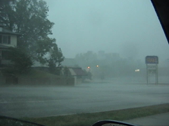
At that point I thought I might still be able to get back ahead of the leading edge of the rain, but it didn't happen, as the storm surged south quickly and I got held up by traffic and stop lights. Shortly later, I broke off the chase and found a parking lot to ride out the storm where I would be safe from falling branches, etc. At that location, I got what could pass as hurricane video, except for the frequent lightning. Intense wind and rain that lasted for at least a half hour, with visibility falling to a couple hundred feet or less at times. Here is a video capture:

chase71906-1.jpg


After the storm finally subsided, I observed lots of branches down all over Springfield, as well as a few trees, and power out in many areas. A lot of emergency vehicle activity, too.

I followed the storm home as it surged south toward the St. Louis area, where it also caused very widespread damage, including measured wind gusts of 84 mph downtown and 92 mph a little north of the metro area. No hope of catching up again, but a good CG show on the way home.

EDIT - 7/23/06: Full chase report is now available at http://www.siue.edu/~jfarley/chase71906.htm

John Farley
Edwardsville, IL
 
No bust here, I hit those storms like they owed me money.

No confirmed tornado, saw something after dark and will have to review the video further tomorrow. Right now I'm driving home but here is an image from todays after dark chase.
The lightning was pretty insane. Some of the best I have ever seen but it got too dangerous to stay out and shoot for a while tonight.

Soutern MN Lightning Photo

DSC_2896_07192006t.jpg
 
Good day,

I was also on the storm system that blasted through western Illinois before slamming Saint louis, MO with winds approaching 100-MPH and hail. The chase began right after work at about 4 PM as I drove I-55 until reacing the fast-moving MCS / Bow near and just south of Springfield, IL. From there, I worked my way back down and near I-55, pretty much back towards Saint Louis, MO. The main thing with this event was WIND - Hurricane forced winds!

My chase log for these storms (2 of which embedded and / or HP supercells) is below...

1). July 19, 6:00 PM: Penetration of a very severe thunderstorm in the southern part of Springfield, Illinois near Interstate 55 and Highway 66 in Sangamon County. The storm was an embedded HP supercell storm in a multicell cluster of very severe thunderstorms. A wall cloud was observed on the southeast side of the storm and tornado warning was put on it (radar indicated). This storm, along with many others in the derecho-like storm cluster / bow had winds gusting from near 60-MPH up to over 80-MPH. Hail in these storms was up to 1â€￾ but most was dime to nickel sized (1/2 to ¾ inch). The storms also produced frequent lightning with many close hits and torrential (sideways driven) rains. Trees and powerlines down, power outages, and some damage to homes was observed with these storms. The fast-moving storms were followed to the south along Interstate 55 for nearly 50 miles. The storms were caused by an upper trough, very strong outflow boundary (originating as far north as Minnesota), and surface heating. Documentation was still digital photos. A 2006 Ford Focus was used to chase the storms. A severe thunderstorm watch as also in effect for the area until 11 PM CDT.

2). July 19, 6:00 PM: Penetration of another extremely severe thunderstorm near Edwardsville, Illinois west of Interstate 55 in Madison County and followed south and southwest along Interstate 255 then Highway 3 through Waterloo and Columbia, Illinois. The storm was another HP supercell storm which had separated from the southern end of an intense multicell cluster of very severe thunderstorms. A large wall cloud (nearly ON the ground – tornado?) was observed with this storm (a tornado warning was put on it for radar indicated strong rotation). A possible view of this tornado appeared as a wall cloud at ground level, rotating (weak tornado wrapped in scud)? The mesocyclone also became apparent as an HP structured storm, with a vault region, wall cloud, inflow banding, and round, striated appearance to the main updraft base / notch (near Edwardsville). This storm had at least 80 to 90-MPH winds and hail up to ¾ inches. The storm also produced frequent lightning with many close hits and torrential (sideways driven) rains. Trees and powerlines down, power outages, and some damage to homes was observed with these storms. This storm, along with others adjacent to it caused massive power outages and damage to the area, from Saint Louis in Missouri to Bellville, Illinois. Winds were near 100-MPH at times and damages may be in the hundreds of millions. The storms were caused by an upper trough, very strong outflow boundary (originating as far north as Minnesota), and surface heating. Documentation was still digital photos. A 2006 Ford Focus was used to chase the storms. A severe thunderstorm watch as also in effect for the area until 11 PM CDT.

Some low-resolution pictures below...

0719mcs1.jpg


Storm gust front and leading edge near Springfield, Illinois. Yes - it was very dark!

0719mcs2.jpg


Just west of I-55 midway between Springfield, IL and Saint Louis, MO. Winds at least 80-MPH and near zero visibility in rain and quarter sized hail.

0719mcs3.jpg


Southbound, inside the storm on I-55, looking out from beneath shelf cloud into the outside world.

Chris C - KG4PJN
 
060720.jpg


Nice morning shelf over the Minneapolis metro area to start the day then Michelle Parker and I headed south to Jackson, MN to meet up with Dave Drufke and Tony Perkins. Hung around George IA watching the parameters (and the cap) go off the charts. VGP was .7 over us for a while...wow! Drifted back north and east with the parameters to Spirit Lake where we waited for the cooling at one of the local resting areas. Cells finally fired just to the north so back to Jackson down to Esterville and over to I35. Great light show and a lot of wall cloud look alikes on the south side of the outflow dominated storms. The remnants of the tornado warned cell had amazing lightning. Was like watching everything through a strobe light.

http://www.mnwxchaser.com/06july19
 
06-7-19-7045.jpg

It got so hot in nw IA yesterday they had to turn the fans on! Ok, I am fully aware of how corny that is so save the pm's.

06-7-19-7043.jpg

Having a blast just trying to drive home(note the hood is up....new radiator will be installed this weekend!). I gave it till 7pm and by then, it was pretty obvious it was not to be, thanks to 16c. Damn now I'm rhyming. 06 "ops" surely need to stop soon.

06-7-19-7112.jpg

Since my car was wanting to overheat right as I entered all these wind farms I wound up intriqued by the photo ops they could make.

All in all one horribly hot day in nw IA. What a waste of shear and instability. One gets used to these kind of busts in the MO. River valley. They are just so good at it.
 
Arrived in Spencer, IA at 3pm. At the time there was a building cumulus field, incredible severe parameters & strong moisture convergence. I was pretty optimistic, that is until I watched every cloud in the sky disipate. So, I waited around Spencer until 8pm and then started working my way home. Just barely on the interstate from Jackson, I noticed some weak echoes from West of Windom. I stopped in Lakefield and waited a bit to see if the cell was going to intensify. Over the course of the next 15 minutes the cell slowly strengthend and I decided to head towards it. I arrived near the cell at around 8:45, about the same time I arrived the cell immediately breached the cap and became severe. Intense lightning developed quickly around 9:10-9:15 and a large wall cloud and inflow tail formed as it approached Windom. I headed ESE as darkness set in and the tornado warning was issued. Im pretty sure I was on highway 36 at this point. The cell was extremely active at this point, with constant lightning and increasing winds. Then, through the ambient light leftover and the flashing of lightning. Then at around 9:41 lightning/ambient light illuminated a large cone that was quite close (1/4 mile). Very vivid and surreal experience. I was looking more NE at first, where there were some lowered clouds. Figuring that the cell had already made some SE progress. Then on looking directly north, the combination of the leftover twilight and constant flashes, revealed the funnel/tornado. It had classic cone shape and was extended pretty far down. It was closer than I had expected and looked really large at such a short distance. So there was no time for pictures and I plowed south, now more concerned about the second approaching wall cloud. As soon as I got south, I managed to take some pictures of the second cell.


Rode with David Drufke and we ended up in far NW IA in George after meeting up with Bill Doms. We waited and played some cross highway tennis before packing it in and started to head east towards home. We stopped in Spirit Lake for a drink, and emerged later to see lightning to the north. We got lots and lots of lightning. I almost got a headache from the constant strobe effect of it.


DSCN4996.JPG


DSCN5001.JPG


More pictures and a small video of windmills in (what else) lightning here:
http://www.gyruss.org/weather/2006-07-19/index.html
 
Iowa Cap: 2
Yours Truly: We'll call it 1/2

I headed out to Iowa again, just like on June 20th. I had better hopes for this time around but alas there is drought everywhere and in every aspect. I headed west on I-90 across southern Minnesota, to Albert Lea, after passing through the squall around La Crosse, Wisconsin. I was leery of the day once I saw how widespread the precipitation was at 11:30 am when I encountered it, remembering the similarity to the 20th. At I-35 I went south to the first wireless internet rest area in Iowa. But someone forgot to tell them to turn it on. :rolleyes: So I busted down I-35 to the next wireless access rest area about 40 miles to the south. I got reception at this one and quickly signed my life away to have the priviledge of using the internet connection. It turns out that where I discerned I needed to head to, after looking at data, was about due west of where I was. So I headed back north 3 miles to IA 3 and busted west. I went as far west as Pocahontas, "The Princess City." :rolleyes: I headed north on IA 4 a little ways and got off on side gravels to monitor the skies. Nothing but scuzzy, fuzzy, low, junk clouds heading to the northwest. Back to IA 4, I continued north through the town of "Friendly Ducks," Mallard, IA :rolleyes: I continued north to Emmetsburg, where I got some supper. On the eastern outskirts of town I saw a couple of chasers pulled over, one was talking on a cell phone and the other was wearing an OU T-shirt. Was that anyone on this forum? I found another spot to watch the scuzz :rolleyes: and listen to weather radio for updates. The 7:00 pm report for Estherville was a thunderstorm, so I cruised that way, seeing nothing resembling a thunderstorm the whole way there. Upon nearing Estherville I swear I saw Don Quixote dismounting from a steer...(yes, when another bust is looming our camera finger gets itchy to shoot something, anything, and the wind turbines seemed to be the popular choice this day)

IMG_0537.jpg


On the north side of the apparent convection, I could clearly see the very elevated updrafts and their bases. After a little bit I was very pleased to notice a CG. Since I had to get back to eastern Wisconsin and put a few hours of work in before 7 am, I followed this convection to the east. The Cg's became a little more numerous and more elevated updrafts began to form, so my desire to get some lightning pics was piqued. Once dusk settled in I busted south a bit from IA 9, toward the convection. About 20 miles northwest of Clear Lake I stopped to get some lightning pics from the established updrafts. As I became slightly agitiated at the paucity of CG's, a new updraft formed nearly overhead and I was soon greeted by some awesome, close CG's. Links to the pics follow:

Photobucket
Photobucket
Photobucket
Photobucket

I headed back to I-35 north and then to I-90 east, while seeing the nearly continuous lightning from the new, vigorous storms in southern Minnesota. Too bad I didn't have the time to explore them. I was inundated by heavy rain and continuous lightning most of the way across Wisconsin. The lightning was spectacular with strobe light effect and 2 second discharges of 8, 10, 12 strokes, anvil crawlers that ended with great CG discharges. The whole beautiful gamit.
 
Chased locally around STL metro area. Almost headed to the IL side of the river and wished I had since that’s where the tornadic part of the storm was but I had stayed in St. Charles county where the flood plain gave me a flat viewing area. A rather difficult chase since there was so much dust and debris blowing and trees and debris blocking roads and traffic jams from over turned semis. Light show was incredible though on the back side of the storm with a lot of anvil crawlers. 600,000 homes/businesses lost power. MO governor declared a state of emergency for STL and brought in the Nat’l Guard. I’ll have my lightning pics developed in a few days and will to post a few if I like them.
 
Back
Top