Mikey Gribble
EF5
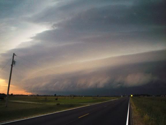
I was on the storm in Reno county Kansas and got one tornado. I was chasing up North yesterday so I spent the night in Nebraska last night. I over slept this morning and didn't wake up until 11. I did my forecasting as quickly as possible and realized central Kansas was going to be my new target so I had to haul butt to get down there. I got on the first tornado warned storm near McPherson. It had a low base and looked pretty good. About 15 minutes later it started to fall apart. I checked radar and thought that the storm to the SW near Hutchinson would have some tornado potential. The storm was moving NE at the time and I was hoping that it would get rooted in the outflow boundary that the McPherson storm was tracking down or I figured the McPherson storm had put out a nice OFB when it collapsed. The storm went tornado warned when I was about halfway to it (15 minutes away). I intercepted the storm by Hutchinson. Here is a picture of the storm about 10 minutes after I got on it.
 [/url][/img]
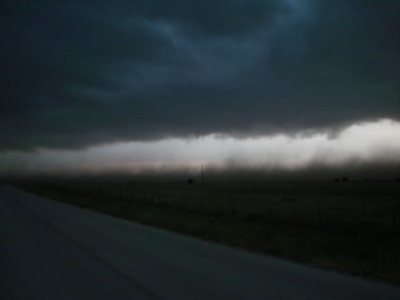
Shortly after this picture, it became very obvious (from where I was a couple miles ahead of it) that the storm scale low was rapidly developing/intensifying directly West of me. You could see the RFD surging forward and you could see some low level clouds getting pulled into the occlusion. I was on the top of a hill and could see a couple cars about two miles West of me (I would assume they were chasers) and one truck North of me a mile. Other than those three cars, I didn't see any one within 3-4 miles of me so I seriously doubt anyone other than the local(guy parked North of me) and I saw the tornado. The people to the West would have had rain blocking their view. I moved North up the road a mile to get in close to where it looked like the occlusion was. Here is a picture right before I moved.
 [/url][/img]
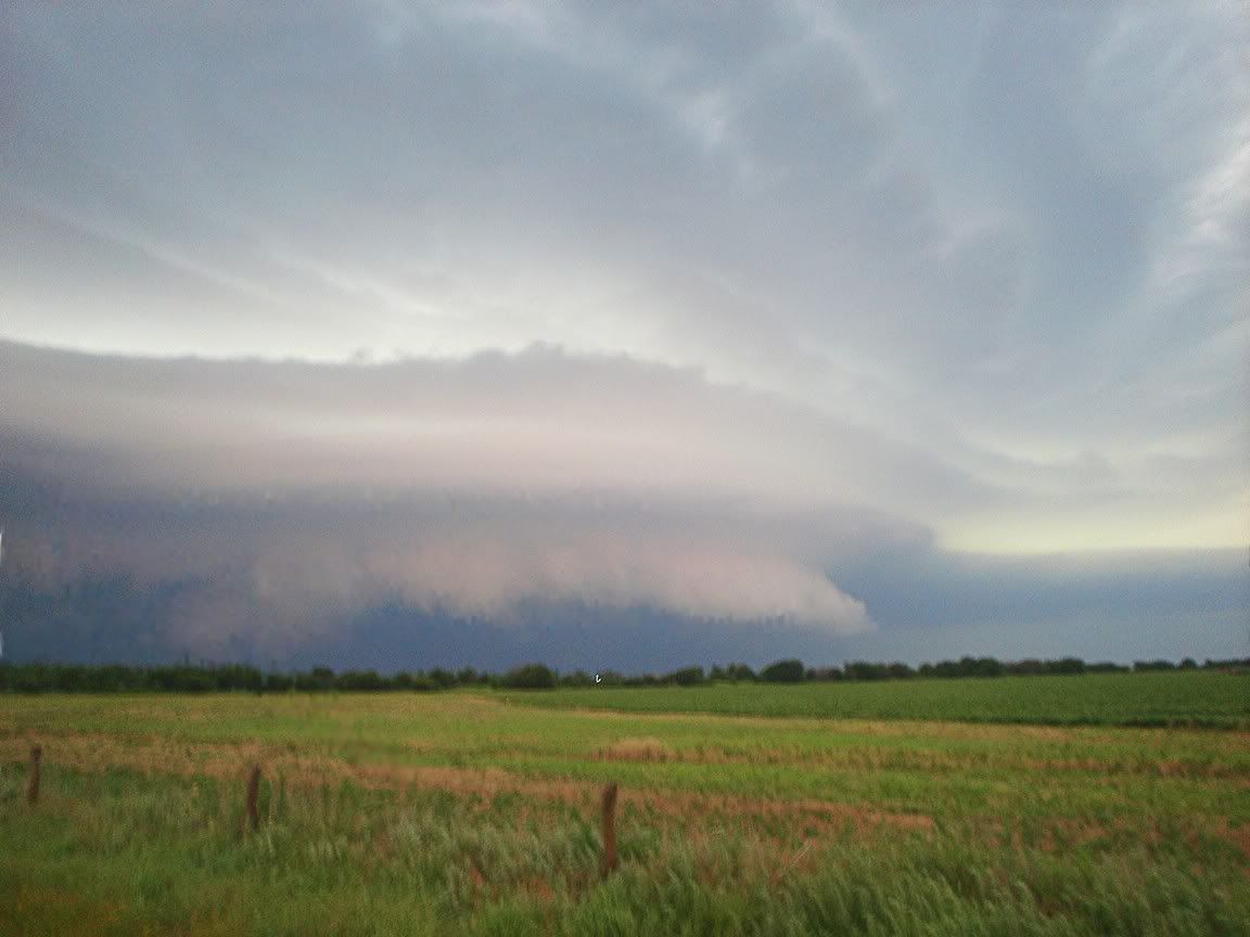
When I was about halfway down the mile section driving North I saw a rope tornado form rapidly and touch down West of the road. When I turned the corner there was a local parked on the side of the road. I asked him if he saw the tornado and he said there were two of them. After that I saw several more skinny rope funnels. Like Philip said in the other thread, there was a broad area of rotation and it was tough to tell what was going on sometimes. I never got any video of the tornado because I was driving at the time and it didn't last very long. I was just worried about gettig out of its way. It was only about 200 yards West of me and it was moving very quickly to the East. Here is a video grab from one of the other funnels. This was very similar to the tornado and all the other funnels. They were all skinny ropes.
 [/url][/img]
 [/url][/img]
This storm had probably the fastest vertical motion I have ever seen when there wasn't a tornado on the ground. It was pretty incredible. I kept on getting pounded by the gust front which was packing very strong winds. At different times throughout the evening I was in winds that I think would have been over 70mph. I never got out the anemometer so I don't know exactly how strong they were. I checked SPC storm reports and saw that there were 4 tornado reports out of this storm. I could have missed one or two, but I am going to have to call BS on 4 tornadoes. The gust front kicked up dust at times and I saw one gustnado. It was a very tough storm to chase. Lots of wind and rain and the tornado and funnels were wrapped up in rain. I was pretty pumped to get another tornado and the funnels were nice too. The vertical motion during a 15 minute span of time starting with the tornado provided the best show of the night for me. The vertical motion was intense and it was really incredible to watch. The rope funnels would form very rapidly and would twist and turn before falling apart as quickly as they appeared. There was a point around the time when I was seeing funnels when you could hear the wind. It didn't really sound like a tornado, it was more of a jet engine and a whistling sound. It was the first time I had ever heard that before. It was a great chase and it was close to home which made it even better.
Shortly after this picture, it became very obvious (from where I was a couple miles ahead of it) that the storm scale low was rapidly developing/intensifying directly West of me. You could see the RFD surging forward and you could see some low level clouds getting pulled into the occlusion. I was on the top of a hill and could see a couple cars about two miles West of me (I would assume they were chasers) and one truck North of me a mile. Other than those three cars, I didn't see any one within 3-4 miles of me so I seriously doubt anyone other than the local(guy parked North of me) and I saw the tornado. The people to the West would have had rain blocking their view. I moved North up the road a mile to get in close to where it looked like the occlusion was. Here is a picture right before I moved.
When I was about halfway down the mile section driving North I saw a rope tornado form rapidly and touch down West of the road. When I turned the corner there was a local parked on the side of the road. I asked him if he saw the tornado and he said there were two of them. After that I saw several more skinny rope funnels. Like Philip said in the other thread, there was a broad area of rotation and it was tough to tell what was going on sometimes. I never got any video of the tornado because I was driving at the time and it didn't last very long. I was just worried about gettig out of its way. It was only about 200 yards West of me and it was moving very quickly to the East. Here is a video grab from one of the other funnels. This was very similar to the tornado and all the other funnels. They were all skinny ropes.
This storm had probably the fastest vertical motion I have ever seen when there wasn't a tornado on the ground. It was pretty incredible. I kept on getting pounded by the gust front which was packing very strong winds. At different times throughout the evening I was in winds that I think would have been over 70mph. I never got out the anemometer so I don't know exactly how strong they were. I checked SPC storm reports and saw that there were 4 tornado reports out of this storm. I could have missed one or two, but I am going to have to call BS on 4 tornadoes. The gust front kicked up dust at times and I saw one gustnado. It was a very tough storm to chase. Lots of wind and rain and the tornado and funnels were wrapped up in rain. I was pretty pumped to get another tornado and the funnels were nice too. The vertical motion during a 15 minute span of time starting with the tornado provided the best show of the night for me. The vertical motion was intense and it was really incredible to watch. The rope funnels would form very rapidly and would twist and turn before falling apart as quickly as they appeared. There was a point around the time when I was seeing funnels when you could hear the wind. It didn't really sound like a tornado, it was more of a jet engine and a whistling sound. It was the first time I had ever heard that before. It was a great chase and it was close to home which made it even better.