-
While Stormtrack has discontinued its hosting of SpotterNetwork support on the forums, keep in mind that support for SpotterNetwork issues is available by emailing [email protected].
You are using an out of date browser. It may not display this or other websites correctly.
You should upgrade or use an alternative browser.
You should upgrade or use an alternative browser.
6/3/08 Reports: IL/MO/IA/IN/KS
- Thread starter Brandon Sullivan
- Start date


Brian Stertz
EF5
Chased some VERY local decent supercells in Johnson Co. KS. The obvious factor missing to keep the mesos from tornado production was the badly veered LLJ. This kept the fairly strong circulations from wrapping up all the way....and then later aided in gust out cycles. Saw some great structure and features and w/o a doubt the supercells all featured some degree of rotation. I think the lighter inflow probably kept the updraft rotation areas from developing a definable strong couplet and from being officially tornado warned. By far and away the strongest and most menacing rotation I saw was with the supercell between Lenexa and Olathe. Thought for a moment I would get one down for a brief period. Pics to follow later.
Mike Peregrine
EF5
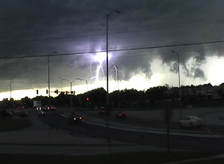
It's nice when a person can see the stuff we did tonight without getting more than ten miles from home. This ended up being an exciting, fun, and visual chase. I got ahead of the first storm coming over the city, and positioned myself off of 291 south, just south of Lee's Summit. Saw the wall cloud right away, but it looked pretty disorganized/gusty at first. Then it came together in a big way ... easy to see RFD notch formed and the circulation made an attempt to tighten up. Brian is right ... if our wind had been just a little more favorable, parts of this town would be a mess right now. There was a good funnel that formed and persisted for around 5-10 minutes. And then the lightning. Other than the Glen Elder storm, this was the best lightning yet for me this year. Took the time to stop and take photos of it. This was such a satisfying little chase for me. Really enjoyed it.


Very large fire here from lightning ... a gas tank (one of the great big ones) evidently was struck and blew up. Could see the smoke through the lightning all over town.
I do need to make one more quick edit ... the photos above were taken as the tornado warning was issued on that cell. It was cool to see the rotation tighten up, and simultaneously hear the sirens go off in Lee's Summit. It was not so cool trying to chase that thing around 291 highway just after rush hour. I think I left at 6:30, and those photos would have been taken near 7:25-7:30, as I was making the posts in the now thread about what I was observing. Had to go get a new laptop today, so SN isn't up and running yet.
Last edited by a moderator:
Brian Stertz
EF5
Johnson Co. KS supercell
This was a very low wall cloud that moved slowly east-southeast in between Olathe and Lenexa (Johnson Co. KS). The time of this photo was 7:12pm and I am looking west-northwest. Things would have been totally different had the LL jet had been more southerly or southwesterly. No official tornado warnings for this cell. All in all a fun local chase ....as Mike mentioned these supercells had some terrific CG activity.

This was a very low wall cloud that moved slowly east-southeast in between Olathe and Lenexa (Johnson Co. KS). The time of this photo was 7:12pm and I am looking west-northwest. Things would have been totally different had the LL jet had been more southerly or southwesterly. No official tornado warnings for this cell. All in all a fun local chase ....as Mike mentioned these supercells had some terrific CG activity.
Andrew Pritchard
EF5
Caught the Manchester Illinois tornado with the company of Mark Sefried, Scott Kampas, Darin Kaiser and Brad Emel. Didn't think we'd have enough flow at the low levels to get the job done but this minisupercell hit the ofb and went nuts for a bit.


Video uploading now... here's a structure shot of our second storm near Carrollton, IL near sunset.

EDIT: Youtube is being lame tonight so I threw a heavily compressed version of the video onto the stormtube website.
Video:
http://www.stormtube.org/play.php?vid=169
Video uploading now... here's a structure shot of our second storm near Carrollton, IL near sunset.
EDIT: Youtube is being lame tonight so I threw a heavily compressed version of the video onto the stormtube website.
Video:
http://www.stormtube.org/play.php?vid=169
Last edited by a moderator:
John Farley
Supporter
Congrats to you guys that got the Manchester, IL tornado. I probably should have stayed in IL, but got suckered west into MO by the better instability there. I guess we kind of switched positions from the last chase; IL alway seems to turn out better, LOL!
As it turns out, I caught 3 nice supercells around the Troy-Bowling Green, MO area, two of which produced - but bad road networks, darkness, the Mississippi River, and a navigational blunder conspired to keep me from seeing the tubes. So in the past week, my tally is at least 5 tornadic storms but no tornadoes. But despite this frustration, still not a bad chase, as once again I got some great structure:

Almost certainly not a funnel, though it may have been reported as such. First of the 3 storms, southeast of Bowling Green, MO looking north sometime around 7:00 p.m.

Same storm and location, a few minutes later. The storm was now evolving into an HP supercell.

Nice wall cloud and another interesting non-funnel lowering underneath. This was on the second storm, 5 or 10 minutes later. This wall cloud did eventually develop some rotation, before becoming scuddy and disorganized.
Later, one of these storms - I'm not sure which one, and they may have merged - started looking real organized again, but it was crossing the Mississippi River - and the only bridge within 75 miles would have put me on the wrong side of the storm. Of course, it produced once it crossed the river.
I later caught a 3rd storm which exploded from a very ordinary thundershower into a spectacular supercell with a nice wall cloud in about 15 minutes around sunset northwest of Troy - but poor road choices and the hilly woods of MO kept me from seeing the tornado it dropped in Whiteside. By then, I was hopelessly in the jungle - through a break in the trees and by the backlighting of lightning, I got just one glimpse of the wall cloud about the time of the tornado - there were some pointy lowerings visible, but they were near the front edge and looked more like scud fingers than a tube, as best I can recall from the brief glimpse I got.
Full report and more pics coming to my Web site when time allows - will post the link when it is ready.
As it turns out, I caught 3 nice supercells around the Troy-Bowling Green, MO area, two of which produced - but bad road networks, darkness, the Mississippi River, and a navigational blunder conspired to keep me from seeing the tubes. So in the past week, my tally is at least 5 tornadic storms but no tornadoes. But despite this frustration, still not a bad chase, as once again I got some great structure:
Almost certainly not a funnel, though it may have been reported as such. First of the 3 storms, southeast of Bowling Green, MO looking north sometime around 7:00 p.m.
Same storm and location, a few minutes later. The storm was now evolving into an HP supercell.
Nice wall cloud and another interesting non-funnel lowering underneath. This was on the second storm, 5 or 10 minutes later. This wall cloud did eventually develop some rotation, before becoming scuddy and disorganized.
Later, one of these storms - I'm not sure which one, and they may have merged - started looking real organized again, but it was crossing the Mississippi River - and the only bridge within 75 miles would have put me on the wrong side of the storm. Of course, it produced once it crossed the river.
I later caught a 3rd storm which exploded from a very ordinary thundershower into a spectacular supercell with a nice wall cloud in about 15 minutes around sunset northwest of Troy - but poor road choices and the hilly woods of MO kept me from seeing the tornado it dropped in Whiteside. By then, I was hopelessly in the jungle - through a break in the trees and by the backlighting of lightning, I got just one glimpse of the wall cloud about the time of the tornado - there were some pointy lowerings visible, but they were near the front edge and looked more like scud fingers than a tube, as best I can recall from the brief glimpse I got.
Full report and more pics coming to my Web site when time allows - will post the link when it is ready.
Dick McGowan
EF5
Derek Shaffer and I were on a tornado-warned storm somewhere NE of KC, where we trailed it until dusk. Right as it was tornado-warned, we had a clear view of a nice beefy wall cloud just to our east, before we were blasted with RFD and our view was obstructed for the next 10 minutes. The storm began to look outflow-ish after that, had a last attempt at tornadogenesis, with a nice clear slot cutting in and decent rotation with scud being pulled hard into it. But it appeared high-based, and appeared to gust out near dusk. We pulled up to an Amish farm right before that, where we talked to a family for quite some time. They had never seen radar before and were pretty amazed by it, and I did my best to explain that in the simplest terms possible, along with cloud features. He told us some 1 inch hail destroyed some of his corn not too long ago and a window in his barn. They were busy plowing the fields with 2 horses when the storm was approaching to the north. If anyone complains about how hard they have it, go see how the Amish live. They were extremely friendly and told us some stories of storms in the past. Some moron came flying up the hill and nearly killed 2 of the little girls taking their horse across the road.
We shot lightning till 2 a.m., towards the end, on top of a parking garage in downtown K.C., and almost had the shot I was looking for, but the rain was too much.
Not a bad day, decent structure, slow-moving storms, a great lightning show and had a nice conversation with some nice people.


We shot lightning till 2 a.m., towards the end, on top of a parking garage in downtown K.C., and almost had the shot I was looking for, but the rain was too much.
Not a bad day, decent structure, slow-moving storms, a great lightning show and had a nice conversation with some nice people.
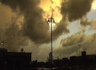
We saw plenty of severe weather last night, including the wall cloud in Johnson countly close to Olathe when we were following the storm that fired up just SE of Lawrence KS last night. We made our way to the east side of town just east of Blue Spring Lake at a Great West bank under an overhang where we could take plenty of photos and stay somewhat dry and hail free. I kind of wish we would have stopped of in Lees Summit because the storm had rained like crazy and was decreasing in intensity by the time it got to our location. The best digital pic I could find was when we arrived at our motel in Lees Summit and a little break in the clouds to the west revealed some blue sky with an orange hue. My camera shows 7:44 pm but that's MST so it's really 8:44 pm CST. All in all it was a good chase - I think we just went a little too far east in hopes that the cell would strengthen as it worked it's way towards us.
Mark & Jane
Mark & Jane
Attachments

Olivier Staiger
EF3
6/3/08 REPORTS: KS
Howdy foks,
I in Colby, did laundry, got a haircut, waited hours, later drove to Goodland, storm was crappy but as it moved into much better dewpoints it got great but too much outflowishywashy
got on some dirt roads SW of Colby somewhere ... ( lost ? me ? nooooooo....)
;-)
nice outflow dust gusting
clip : http://www.youtube.com/watch?v=XudWRvINIG0
live and nearlive broadcasting http://www.klipsi.ch/twistandshout.htm
overnight and lightning in WaKeeney
Attachments


Tim Marshall
EF2
We waited in ICT (my target) for storms to fire ... meanwhile, a supercell developed in the far west OK PH ... too far away to do us any good. Or so we thought. Storms finally began to fire late in the day (after 7 pm) just south of the KS border in OK, south of ICT, so we started that way. We saw the high-based storms develop on I-35 but the anvil from the approaching storm from the far west soon overspread them and the storms died quickly. So, we headed west toward Alva, OK and an HP came rapidly into view as it was moving toward us at 40 MPH+. We observed wild action under bases on the north side and a wall cloud on the south flank with dark precip in between. Dust on the ground under the shelf indicated to us that there would be strong winds. Unfortunately, I misjudged the speed of the storm and it caught us in Manchester, OK. We tried to ride out the storm in the lee of a barn but that didn't work. We estimated wind gusts reached 60 mph in blinding rain AND blowing dust. There was minor damage in/near town, (i.e. a downed television tower adjacent to someones house, a cracked and leaning power pole, some missing roof shingles, and unanchored stairs that rolled over that led to a mobile home), but fortunately we encountered no hail. For about 10 min, it was very dark, with strong winds, dust, and rain combining to make for poor visibility, and the Pickup rocked with the gusts. After passing, the storm rapidly transitioned into a bow echo, which we trailed back to ICT then on to our motel in SLN. TM
Mike Peregrine
EF5
Mark - that's so cool ... I had to stop and take a photo of the exact same thing. It was a beautiful little celestial glimpse through the Cu. I bet it was gorgeous from behind the storms. My family in St. Joe tell me their view of the storms from up there was totally breathtaking. They said that they completely filled the southern sky, and the storm tops looked incredibly high.

Last edited by a moderator:
D. Hayes
Beautiful photos Olivier. I was in Rose Hill just east of Wichita when the storm hit us around 9:30pm. There were reports of wind gust in Mulvane of 75mph. About 3 minutes later the storm hit us with around 40mph winds. I was hearing reports from Winfield of a roof coming off a building in town which could of been from that 75mph gust from Mulvane. I was pretty busy trying to spot any rotation over head so I wasn't able to keep track of much else. GRL3 was showing all sorts of mesocyclones in the red low and high. I got a fantastic photo of low reaching cloud to cloud lightning bolt minutes into the storm. It was pretty hair raising for me being a rather new storm spotter.
Now I've taking a lot of lightning photos but this one is a odd ball for sure.
![Storm 032 [640x480].JPG](/proxy.php?image=http%3A%2F%2Fwww.impact9.com%2FStorms%2FStorm+032+%5B640x480%5D.JPG&hash=500c60b1c53d795adb54354f784ec8b0)
Dory
Now I've taking a lot of lightning photos but this one is a odd ball for sure.
Dory
Last edited by a moderator:
Jeff Snyder
EF5
Not much to report... Left w/ the W-band radar truck towards S KS, making the decision to head W towards the GUY supercell as opposed to northeastward towards EMP. We got to P28 in time to notice the HP supercell to our SW begin to gust/bow out, so we called it off and headed to GBD for the night.
The 4km NSSL WRF absolutely nailed the convection that tracked along the OK/KS border from the OK panhandle... It got the main structure of the supercell correct (23-00z), and it got the subsequent evolution into an outflow-dominant bow structure correct (1-3Z). In addition, it also forecast the redevelopment of an E-W line of strong convection to the west of the primary bow near 3-4 Z. I think the EMC 4km WRF had a similar forecast, but the new run was alread posted by the time I started looking at forecast verification. I made a short and small (<2 MB) "movie" of the VNX vs. 4km NSSL WRF forecast (22-04 UTC, IIRC) at
http://www.tornadocentral.com/now/WRF_VNX_verification.wmv
Now, if only the high-resolution, convection-resolving models could be this good all the time...
Eric Flescher
EF5
6/3 Johnson County, KS chaseday report
Date: 6/3/08
Date: 6/3/08
Time: 6:03 - 10:00 CDT
Target/ Chase: Johnson County, KS (JCKS)
Chase travels : Johnson County, KS (JCKS)
Weather specifics: hail, stormcells, lightning, wallcloudfunnelwannabees
chasing: Eric Flescher
chase rating: 8/10
(1) Finally a day in 2008 to remember that showed some of the beauty and the might of stormy weather.


(2) The day opened to a medium threat via the Storm Center. Stretching from around Olathe, KS to Kansas City and out east into Missouri, things looked promising today. But would the day bring some stormy (stormsatori- aha weather) and stop my draught through several chases so far in 2008?
(3) I waited until later on the day to see whether storms would start to "pop" and where? Then a tornado watch was issued for the same area. I heard a dangerous storm cell was moving in from Desoto, Kansas just west on highway 10. It had hail and more.

(4)I heading out on I-35 North at 119th street, I could see wallcloudfunnelwannabees in the darkening skies. I did not see rotation but things looked promising. I headed North looking for a good overlook towards the West. I found what I was looking for at 95th street, just north of a gasoline station area next to the Holiday Inn. As I watched, the brewing, swirling clouds and scud moving south and north, continued to produce a BTMS (Booming, Thunder and lightning show).
(5) While videotaping and photographing the storm to the west, a van with a couple and their two kids pulled up besides me. They asked what i was doing and we compared notes as the mother/wife was videotaping with her nice Sony HSD camcorder. The father got out and showed me his Blackberry which was fast and Internet ready. A nice visual with The Weather Channel Doppler showed this stormcell and another dangerous one down south (which I made sure to note for later). My treo 650 and the Sprint is not fast enough so I was a little jealous. I did not want to see if my g4 book with wifi could see it as i was too busy marveling and videotaping the storm. Some rain, no hail but tons of ground to lightning (CGs).
The little girl got of the van and said "look there's a tornado" as she looked west. It was "Virga" so I told her it wasn't and what it was in not too complicated language. She seemed to understand while we continued to watch the clouds swirling all around. They then took off while I contented to take some more photos as well.,
There were reports that what we were seeing were wallclouds and funnels. A trainer stormspotter said there was a definite wallcloud and rotation in a wallcloud near Lee Summit, MO as sirens were going off briefly.This was dismissed on air though as I sat just North this time further down north of I-435 on Quivira. I decided not to try to make a run to Lee Summit but engage the incoming storms from the south.
(6) I headed back on I-35 but then headed south to intercept the strengthening stormcells heading into Olathe. I first found a good stop to look just of of 119th street looking west. Not bad. But then I found a better lookout next to the new shopping center SW of 119th and I-35 so I could shoot the real dark ominous storms and lightningfest looking east and west. I continued to shoot the video and photos but my camera card maxed out . (next time before a storm, I need to format the card or have two ). So I just worked on videotaping the sky show.
Beautiful yellow streaks through the sky, grey clouds and even azure blue sky peaking through made for a great contrast of colors. The southern and east storms were producing CGs (Cloud to Ground) and CC (cloud to cloud) as the show continued. A couple came out from the sports shop just to the west and asked what I was doing . They liked looking at the booming skies and we talked a bit. They left and I kept videotaping this lightningboomfest.

9:55 CDT
(7) There was hail and possible hook in a Spring Hill storm.
(8) Heading south on I-35 and I was approaching Spring Hill and Paola. At the Spring Hill line, 1 mile line before SH,9:55 CDT, big hailstones and rain started to increase and started to pelt my car. Sounded big (walnut?) as they "bonked" the hood of my car (small golf ball). I got off at the SH exit and looking west, I videotaped the hail through my windshield. It was raining too hard to get out and try to pick up some of the hail for souvenir and photos. By the time I could they had already melted.
I then went east turned around and headed back north as small pea hail rained down. This time it was just raining a bit but I did not see any hail that I could pick up.
10:00 CDT(8) I got back home in Olathe at 10:00 CDT. As I got something to eat I started to upload my photos using iPhoto and using my Panasonic camcorder. I also watched the news which showed the oil tank near Kansas City which exploded possibly due to a lightning strike earlier (7:30pm) started earlier in the day when the storms were moving in.
(9) Definitely a Storm Satori Day the best since Hays in 2007. While there was no tornado today for me and no really defined good rotations, the lightning displays and the storm was gorgeous and menacing. While I heard hail I did not see.
I would rate his chase 8/10.; Hopefully even better chases to come.
Target/ Chase: Johnson County, KS (JCKS)
Chase travels : Johnson County, KS (JCKS)
Weather specifics: hail, stormcells, lightning, wallcloudfunnelwannabees
chasing: Eric Flescher
chase rating: 8/10
(1) Finally a day in 2008 to remember that showed some of the beauty and the might of stormy weather.


(2) The day opened to a medium threat via the Storm Center. Stretching from around Olathe, KS to Kansas City and out east into Missouri, things looked promising today. But would the day bring some stormy (stormsatori- aha weather) and stop my draught through several chases so far in 2008?
(3) I waited until later on the day to see whether storms would start to "pop" and where? Then a tornado watch was issued for the same area. I heard a dangerous storm cell was moving in from Desoto, Kansas just west on highway 10. It had hail and more.


(4)I heading out on I-35 North at 119th street, I could see wallcloudfunnelwannabees in the darkening skies. I did not see rotation but things looked promising. I headed North looking for a good overlook towards the West. I found what I was looking for at 95th street, just north of a gasoline station area next to the Holiday Inn. As I watched, the brewing, swirling clouds and scud moving south and north, continued to produce a BTMS (Booming, Thunder and lightning show).
(5) While videotaping and photographing the storm to the west, a van with a couple and their two kids pulled up besides me. They asked what i was doing and we compared notes as the mother/wife was videotaping with her nice Sony HSD camcorder. The father got out and showed me his Blackberry which was fast and Internet ready. A nice visual with The Weather Channel Doppler showed this stormcell and another dangerous one down south (which I made sure to note for later). My treo 650 and the Sprint is not fast enough so I was a little jealous. I did not want to see if my g4 book with wifi could see it as i was too busy marveling and videotaping the storm. Some rain, no hail but tons of ground to lightning (CGs).
The little girl got of the van and said "look there's a tornado" as she looked west. It was "Virga" so I told her it wasn't and what it was in not too complicated language. She seemed to understand while we continued to watch the clouds swirling all around. They then took off while I contented to take some more photos as well.,
There were reports that what we were seeing were wallclouds and funnels. A trainer stormspotter said there was a definite wallcloud and rotation in a wallcloud near Lee Summit, MO as sirens were going off briefly.This was dismissed on air though as I sat just North this time further down north of I-435 on Quivira. I decided not to try to make a run to Lee Summit but engage the incoming storms from the south.

(6) I headed back on I-35 but then headed south to intercept the strengthening stormcells heading into Olathe. I first found a good stop to look just of of 119th street looking west. Not bad. But then I found a better lookout next to the new shopping center SW of 119th and I-35 so I could shoot the real dark ominous storms and lightningfest looking east and west. I continued to shoot the video and photos but my camera card maxed out . (next time before a storm, I need to format the card or have two ). So I just worked on videotaping the sky show.
Beautiful yellow streaks through the sky, grey clouds and even azure blue sky peaking through made for a great contrast of colors. The southern and east storms were producing CGs (Cloud to Ground) and CC (cloud to cloud) as the show continued. A couple came out from the sports shop just to the west and asked what I was doing . They liked looking at the booming skies and we talked a bit. They left and I kept videotaping this lightningboomfest.


9:55 CDT
(7) There was hail and possible hook in a Spring Hill storm.
(8) Heading south on I-35 and I was approaching Spring Hill and Paola. At the Spring Hill line, 1 mile line before SH,9:55 CDT, big hailstones and rain started to increase and started to pelt my car. Sounded big (walnut?) as they "bonked" the hood of my car (small golf ball). I got off at the SH exit and looking west, I videotaped the hail through my windshield. It was raining too hard to get out and try to pick up some of the hail for souvenir and photos. By the time I could they had already melted.
I then went east turned around and headed back north as small pea hail rained down. This time it was just raining a bit but I did not see any hail that I could pick up.
10:00 CDT(8) I got back home in Olathe at 10:00 CDT. As I got something to eat I started to upload my photos using iPhoto and using my Panasonic camcorder. I also watched the news which showed the oil tank near Kansas City which exploded possibly due to a lightning strike earlier (7:30pm) started earlier in the day when the storms were moving in.
(9) Definitely a Storm Satori Day the best since Hays in 2007. While there was no tornado today for me and no really defined good rotations, the lightning displays and the storm was gorgeous and menacing. While I heard hail I did not see.
I would rate his chase 8/10.; Hopefully even better chases to come.
Last edited by a moderator:
Willoughby Owen
EF2
Followed the line of storms which fired up from Kansas City southwestwards along the I-35 towards Emporia.. never became tornadic on the cells we were on, but there were a couple of defined wall-clouds. Had an insane lightning show from sunset until into the night.


Similar threads
- Replies
- 1
- Views
- 250
- Replies
- 8
- Views
- 868