Jason Persoff
EF3
Tornado Hits Jacksonville, Florida
 Photo from Mandarin/Orange Park, FL. Photographers unknown. Copied from WJXT (news4jax.com) and FirstCoastNews.com. June 26, 2009, copyrights unknown.

 We moved to Jacksonville in 1997 and since that time, I've managed to miss every single tornado that has ever hit around Jacksonville. Even when I've come up with a good chasing plan, I never did get lucky, and sometimes I'd miss an especially gorgeous tornado by minutes. With the low cloud ceilings (often less than 1kft AGL).
Today, however, luck (I was at work tonight--an unplanned shift to assist a colleague and therefore was in perfect placement) and a terrific friend, colleague, and future storm chaser, Dr. Michael Maniaci conspired to my benefit.
Synoptic Background:
There was no evidence that there would be anything more than pop-up thunderstorms typical of summertime in FL. The sfc observations revealed a very mild low pressure system centered over Alabama with very little in the way of brisk sfc winds. In retrospect, however, the low pressure was sufficient to create marginally good westward sfc winds over the FL PH which likely led to a delay in the normal westward movement of the seabreeze which occurs typically early in the afternoon.

T/Td spreads were around 20 degrees (90/70) in JAX in the morning and were forecast to narrow (90/75) prior to peak daytime heating. The upper air situation was unusual in that 700mb temps were less than 10 degrees as opposed to the usual subtropical temperatures typical during the summertime. As is seen below, the hodograph favored largely stationary storms with high precipitation and no upper level support for large scale storm rotation.

Mesoscale Evolution:
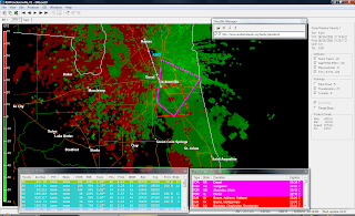
As the afternoon developed, a mesolow appeared over JAX and slightly offshore. The seabreeze did start as usual, but was very delayed by the sfc westward winds resulting in an afternoon seabreeze still laying across the JAX area by 21z. The SB can be easily delineated on BR draped from NW to SE.
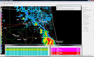
The SB led to an area of strong sfc convergence in St. John's Cty (south of JAX) and created a line of typical summer pop-up storms in that area. However, on the northern fringe of the storms, the SB had a kink in it which is also visible in the image above. A separate cell nestled into that area and rapidly developed into a non-embedded cell. Although I don't have enough sfc data to know for sure, I suspect that winds south of the cell were out of the east and north of the cell were out of the NE leading me to believe a mesolow had formed in that area in response to the pinned up SB.
The northerly cell almost immediately developed deviant leftward motion and began to "ride" the SB like a zipper.
As it rode the seabreeze, it immediately developed moderate midlevel rotation seen on the lower tilts.
The storm gradually continued its left turn and accelerated slightly, but continuing to ride the seabreeze. At about 2050z the first reports of a tornado were noted. At 2055z, my partner, Dr. Maniaci, contacted me stating he was staring at a large tornado on the ground (which, after my lackluster season this past year, was something I felt was poor form to tease me about). After a minute of me convincing him that he was hallucinating, he said, "Go LOOK!"
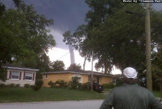
I shot up to the 5th floor of our hospital and immediately saw the tornado. It was a dramatic sight since I'd never ever thought I'd see one here. The T/Td spreads were perfect giving the storm base a relative higher height than is often seen here. There was a perfect cylindrical tornado easy to spot about 10 miles to my west and moving northward at about 5-10mph. I tried to capture images w/ my cell phone, but the distance focus on this thing sucks, so you'll have to trust me when I tell you what it looked like from here. Fortunately, lots of other folks were in much better positions to capture the tornado, and I share their photos here.

This first photo is from the FL Dept of Transportation showing the tornado with good backlighting. While I was sure the storm had been reported, I didn't get my usual phone notification of warnings in our area. I called NWS JAX and told them what I was seeing. This jived with several calls they were getting simultaneously and a TORNADO WARNING was issued for Duval County. I then called our operator at the hospital and asked them to initiate a TORNADO notification overhead (but truthfully, our hospital was never in anyway in jeopardy as the tornado would not move near us).

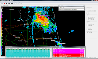
The next SRV1 tilt shows the tornado in the middle of the warning area, but without a mesocyclone indicator. At that time, visually the tornado had a very classic supercell appearance.
A midlevel feeder band (Beaver Tail) was coming in from the east into the parent storm and there were striations visible along the wall cloud and base. To the north, propagating storms began to form. On the radar, the seabreeze breaks south of the storm and begins to march due west. However, two separate boundaries (the northern portion of the SB) and some other area of convergence "scissored" together in N JAX leading to brief intensifcation of the storm (a mesoscale hiccup) and this can be seen on the following BR image). I should note that visually the boundary to the east of the storm was highly visible with low-level scud getting kicked up along it.
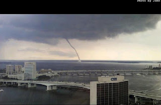
This led to the most visually dramatic portion of the storm which is captured best in the next two photos from Downtown JAX. The first was again anonymous from WJXT. The second photo was sent to me from one of my friends, Dr. Matt Geraci, from Baptist Hospital in Downtown JAX. Unfortunately, since the tornado was at this point over the St. John's River, it was called a waterspout by all popular media and I disagree since I believe this was in fact a true mesocyclone tornado with some non-MST features (weak circulation aloft but with highly visible structure consistent with a typical MST).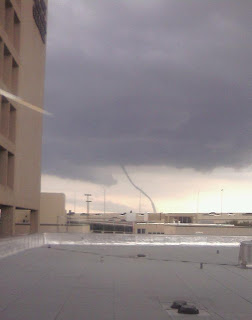
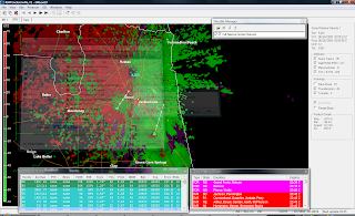
After about 20 mins, the tornado dissipated as the RFD wrapped around with a clear slot visible. To the northeast of the occlusion, a new wall cloud formed with intermittent cloud debris seen at the sfc.
In both photos (which were shot from the NE of the TOR looking SW), you can see the occlusion from the RFD behind the storm, the associated wall cloud, and kinking in the base of the tornado due to collision with the easterly boundary. This was not due to any precipitation east of the tornado: there was no precip east of it. So the kink was due to the sfc boundary in that area, I believe.
I did manage to get a single so-so photo of the boundary and the associated updraft and anvil. This was looking NNW from Mayo Hospital and the quality is better than the other photos I have but still pretty grainy/crappy.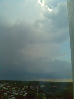 That said, features can be identified including the low-level convergence field draped from the right to left of the photo and midlevel clouds moving into the parent updraft near the top of the photo with a hint of blue sky just behind the anvil.
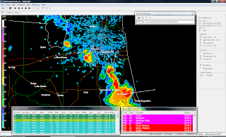
My chase partner, Dr. Bill Hark in Virginia, was one of my first contacts (following making sure my wife and children were doing okay with the storm which still passed well west of our home). He was nice enough to send me this animated WeatherTap (c) gif of the radar loop. Notable in the loop is just how quickly the northern cell accelerated after breaking from the other cells, and just how deviant its motion was from the mean.
This was such a great surprise and totally and completely makes me overjoyed. For a short time I was emotionally and spiritually back on the chase, and it reminded me why I so totally love this hobby. It also accentuates just how lucky you have to be sometimes and just how much more there is to learn.
My thanks to everyone who was kind enough to help me get this blog completed. My special thanks to Dr. Maniaci, though: I am delighted you thought first to call me. What a great surprise this was.
Comments/feedback are welcome, naturally. I will willingly remove any photograph that anyone feels is a copyright violation or violates public domain.
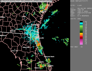
 Photo from Mandarin/Orange Park, FL. Photographers unknown. Copied from WJXT (news4jax.com) and FirstCoastNews.com. June 26, 2009, copyrights unknown.
 We moved to Jacksonville in 1997 and since that time, I've managed to miss every single tornado that has ever hit around Jacksonville. Even when I've come up with a good chasing plan, I never did get lucky, and sometimes I'd miss an especially gorgeous tornado by minutes. With the low cloud ceilings (often less than 1kft AGL).
Today, however, luck (I was at work tonight--an unplanned shift to assist a colleague and therefore was in perfect placement) and a terrific friend, colleague, and future storm chaser, Dr. Michael Maniaci conspired to my benefit.
Synoptic Background:
There was no evidence that there would be anything more than pop-up thunderstorms typical of summertime in FL. The sfc observations revealed a very mild low pressure system centered over Alabama with very little in the way of brisk sfc winds. In retrospect, however, the low pressure was sufficient to create marginally good westward sfc winds over the FL PH which likely led to a delay in the normal westward movement of the seabreeze which occurs typically early in the afternoon.

T/Td spreads were around 20 degrees (90/70) in JAX in the morning and were forecast to narrow (90/75) prior to peak daytime heating. The upper air situation was unusual in that 700mb temps were less than 10 degrees as opposed to the usual subtropical temperatures typical during the summertime. As is seen below, the hodograph favored largely stationary storms with high precipitation and no upper level support for large scale storm rotation.

Mesoscale Evolution:
As the afternoon developed, a mesolow appeared over JAX and slightly offshore. The seabreeze did start as usual, but was very delayed by the sfc westward winds resulting in an afternoon seabreeze still laying across the JAX area by 21z. The SB can be easily delineated on BR draped from NW to SE.

The SB led to an area of strong sfc convergence in St. John's Cty (south of JAX) and created a line of typical summer pop-up storms in that area. However, on the northern fringe of the storms, the SB had a kink in it which is also visible in the image above. A separate cell nestled into that area and rapidly developed into a non-embedded cell. Although I don't have enough sfc data to know for sure, I suspect that winds south of the cell were out of the east and north of the cell were out of the NE leading me to believe a mesolow had formed in that area in response to the pinned up SB.
The northerly cell almost immediately developed deviant leftward motion and began to "ride" the SB like a zipper.

As it rode the seabreeze, it immediately developed moderate midlevel rotation seen on the lower tilts.

The storm gradually continued its left turn and accelerated slightly, but continuing to ride the seabreeze. At about 2050z the first reports of a tornado were noted. At 2055z, my partner, Dr. Maniaci, contacted me stating he was staring at a large tornado on the ground (which, after my lackluster season this past year, was something I felt was poor form to tease me about). After a minute of me convincing him that he was hallucinating, he said, "Go LOOK!"
I shot up to the 5th floor of our hospital and immediately saw the tornado. It was a dramatic sight since I'd never ever thought I'd see one here. The T/Td spreads were perfect giving the storm base a relative higher height than is often seen here. There was a perfect cylindrical tornado easy to spot about 10 miles to my west and moving northward at about 5-10mph. I tried to capture images w/ my cell phone, but the distance focus on this thing sucks, so you'll have to trust me when I tell you what it looked like from here. Fortunately, lots of other folks were in much better positions to capture the tornado, and I share their photos here.

This first photo is from the FL Dept of Transportation showing the tornado with good backlighting. While I was sure the storm had been reported, I didn't get my usual phone notification of warnings in our area. I called NWS JAX and told them what I was seeing. This jived with several calls they were getting simultaneously and a TORNADO WARNING was issued for Duval County. I then called our operator at the hospital and asked them to initiate a TORNADO notification overhead (but truthfully, our hospital was never in anyway in jeopardy as the tornado would not move near us).

The next SRV1 tilt shows the tornado in the middle of the warning area, but without a mesocyclone indicator. At that time, visually the tornado had a very classic supercell appearance.

A midlevel feeder band (Beaver Tail) was coming in from the east into the parent storm and there were striations visible along the wall cloud and base. To the north, propagating storms began to form. On the radar, the seabreeze breaks south of the storm and begins to march due west. However, two separate boundaries (the northern portion of the SB) and some other area of convergence "scissored" together in N JAX leading to brief intensifcation of the storm (a mesoscale hiccup) and this can be seen on the following BR image). I should note that visually the boundary to the east of the storm was highly visible with low-level scud getting kicked up along it.

This led to the most visually dramatic portion of the storm which is captured best in the next two photos from Downtown JAX. The first was again anonymous from WJXT. The second photo was sent to me from one of my friends, Dr. Matt Geraci, from Baptist Hospital in Downtown JAX. Unfortunately, since the tornado was at this point over the St. John's River, it was called a waterspout by all popular media and I disagree since I believe this was in fact a true mesocyclone tornado with some non-MST features (weak circulation aloft but with highly visible structure consistent with a typical MST).


After about 20 mins, the tornado dissipated as the RFD wrapped around with a clear slot visible. To the northeast of the occlusion, a new wall cloud formed with intermittent cloud debris seen at the sfc.
In both photos (which were shot from the NE of the TOR looking SW), you can see the occlusion from the RFD behind the storm, the associated wall cloud, and kinking in the base of the tornado due to collision with the easterly boundary. This was not due to any precipitation east of the tornado: there was no precip east of it. So the kink was due to the sfc boundary in that area, I believe.
I did manage to get a single so-so photo of the boundary and the associated updraft and anvil. This was looking NNW from Mayo Hospital and the quality is better than the other photos I have but still pretty grainy/crappy.
 That said, features can be identified including the low-level convergence field draped from the right to left of the photo and midlevel clouds moving into the parent updraft near the top of the photo with a hint of blue sky just behind the anvil.
My chase partner, Dr. Bill Hark in Virginia, was one of my first contacts (following making sure my wife and children were doing okay with the storm which still passed well west of our home). He was nice enough to send me this animated WeatherTap (c) gif of the radar loop. Notable in the loop is just how quickly the northern cell accelerated after breaking from the other cells, and just how deviant its motion was from the mean.
This was such a great surprise and totally and completely makes me overjoyed. For a short time I was emotionally and spiritually back on the chase, and it reminded me why I so totally love this hobby. It also accentuates just how lucky you have to be sometimes and just how much more there is to learn.
My thanks to everyone who was kind enough to help me get this blog completed. My special thanks to Dr. Maniaci, though: I am delighted you thought first to call me. What a great surprise this was.
Comments/feedback are welcome, naturally. I will willingly remove any photograph that anyone feels is a copyright violation or violates public domain.