6/16/06 REPORTS: MN / SD / NE / KS / OK / TX

Mike Hollingshead

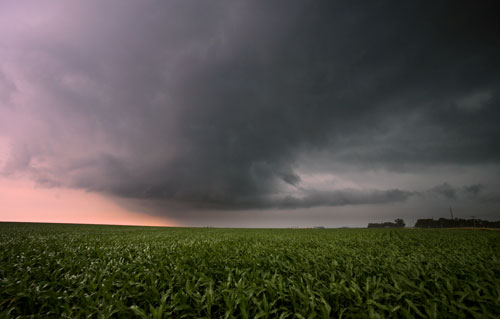
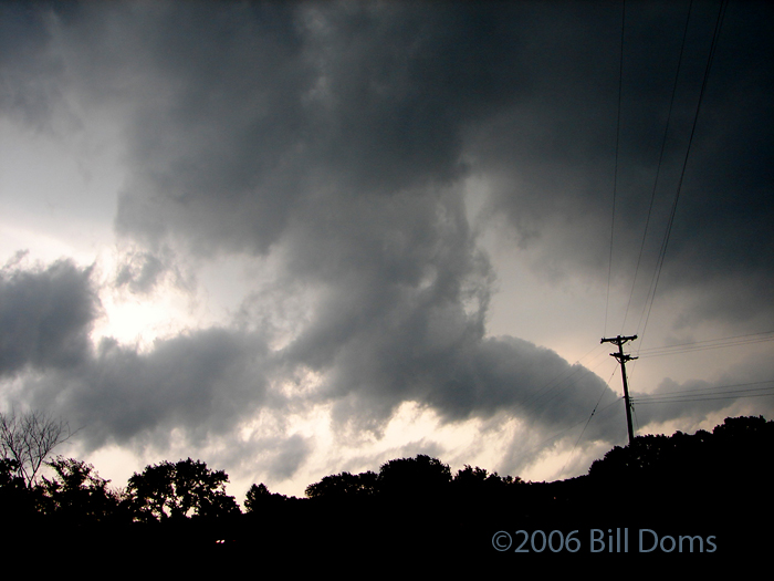
Caught a severe warned storm sw of Columbus NE in the early afternoon. It wasn't very impressive, but around the time it got to Columbus that changed a bit. I flew east of it to the se of Columbus and went north through Schuyler NE before stopping at highway 91. It wasn't easy to beat it there since it was going nne so dang fast. I kept watching it on xm and visually to try and find the apex of the thing and park in it. The highway 91 intersection north of Schyuler looked like the spot. So I pulled over and watched it overtake me. It wound up being a little hurricane of a storm. It had some of the highest winds I've been in. I was recording a sign in the middle of the highway on the south side as it was being twisted pretty violently. I was surprised it wasn't breaking. Then a semi stops next to me at the light and stays there, just blocking my view of that sign so I couldn't keep recording it. Then a good white out hits and the back of the car starts bouncing pretty good. A couple mintues later when it lets up some that sign was now laying on the ground. I was pissed I didn't get it. Anyway, it was a fun little chase for only having to drive 220 miles on the day.
 
I had some concerns from the get-go with moisture and more so with mid/upper level winds and lack of low level shear (or any good directional shear). However, as I got home at noon observations showed widespread mid 60's dewpoints in SE SD. E NE and W IA had widespread 65 and even some 70 degree dewpoints in Iowa. RUC Data/OBS showed more backing than expected in extreme SE SD and the 18z obs for YKN also showed a SE wind (as well as only a 15 Tdd).

Seeing the storms going near North Platte, NE got me out the door and I headed towards Yankton. Upon reaching Yankton I made an error by deciding to go south, prior to this time the cell was moving NE and no particular part of it stood out (quite linear looking intially). As I went south it became clear that the northern area was developing significant rotation and an inflow notch also showed. The cell also took on a more Northerly motion as it moved into South Dakota. Just west of Yankton I caught the cell which looked kind high-based but had scud and lowerings coming down. During this time the cell bowed out with two strong hail cores sandwiching a strong rotating updraft. I lost the northern part pretty quickly as it kept going from rain free inflow area to outflow dominate with a vegnance. I went to the southern part of the cell where the cyclonic mesocyclone was forming and attempting to take a right turn. The structure was amazing, not so much in the striations but the clouds were rock solid teal with a very turbulent look. The color was a very dyanmic teal which showed all over and not just for the hail shaft/rain core. I continued going NE catching cells as they came up, several interesting lowerings seen and strong wind gusts.

The fun continued all the way into Iowa, after 5:00 the cells begin weakening due to interference from convection forming to the east.
 
We couldn't make it far enough south for the storms in Kansas so we targeted the northeast Nebraska region of high CAPE. Unfortunately the early MCS really messed things up in that area so we had to settle for a few messy moderate to strong storm cells moving into NW IA.

http://www.stormeffects.com/recent_events.htm


061606-nwIA.jpg
 
11:04am-11:30pm 6/16/2006.

I went West from Olathe KS after looking at ucar, noaa.
For some reason (one of the earlier reports mentioning going around there) .
I though I should go a little South of I-70. Big Mistake. Wish I had nowcasting.

Through Emporia to Hutchinson things were totally clear. A few clouds started to come up.
After eating at a very good chinese buffet on 11th Street in Hutchinson, I checked a computer at Hutchinson CC. The activity was North!
I hurried North . I heard there were 5 inches of hail in Cheyenne, WY (anybody see this - have pics?).
I was just trying for I-70.
At 5:00, I heard on the radio that there were severe storm warnings South of McCook,NE.
I continued toward I-70 hoping to intercept thunderstorms around I-70.
At 6:30 I could see the darkening sky to the North. No lightning though. It raced East before I could get up there.
I heard about 2 tornado touchdowns. A brief touchdown near Hays, KS and another SW of Goodland, KS.

It was nice drive, Chinese food was great. But dang, no good weather stuff to video or photograph.
It is times I edit storms of the past , the Kansas City action a week or two ago. Now that was some action that I did not miss . It was only 45 minutes away not 4-5 hours like today and nothing to show. :(

Hope you all had better stuff I can look at.
I am back in Olathe.

To take a phrase from the Music group Green Day, so far this 2006 summer is
the (weather) Boulevard of Broken Dreams
 
blah...headed for the OFB near Mankato MN. Nothing too interesting (it is 2006 after all), set up off to the se of the boundary and would follow the cells as they moved off to the ne. When one would die, would loop back south and pick another one as they started to train. Mudslide advisory for Mankato and North Mankato again. Sure made me appreciate being out west the past week and not in the hazy soup up here!

www.mnwxchaser.com/06june16.html

060616003.jpg
 
I did not like the setup at all yesterday so I stayed close to home for the urban chase.

The first storms were around rush hour so I did not even waste my time trying to chase them but the next wave around sunset was just insane. I was in downtown Minneapolis watching man hole covers blowing off due to the water backing up.

Flooding Footage In Minneapolis
 
Got off work around 4:15pm or so just fuled up the car and drove to Columbus NE, didnt seem like i was going to get anything until i got there it was pretty cool how clouds were so low and the heavy rain was visible, i just parked and took a few pics of the whole line and then let it go over me the wind was fun", but mainly the catch was heavy rain WOW lol.. did have a couple of close lightning strikes that let you know it real quick.. all in all i take evry chance i get this year, maybe we can get lucky in the end season ?
 
Caught this funnel East of Hill City. Storm Became outflow dominate and i had to get gas sadly and the area of interest moved to fast and we couldnt get it so we headed to hoxie then south to dighton The storm after we left it of course became tornado warned. XM put a 80Mph shear marker right in the place were the funnel was and you definetly see rotation in it.
_0.jpg

Funnel quickly became wrapped with condensation and became a wall cloud
_1.jpg

Wall cloud
_2.jpg

We went SE of Dighton and cuaght a high based dying supercell as it kinda looked to produce a elongated horizontal funnel maybe tail cloud but was rotating. Andrew has pic of this. Then we headed back up to dighton to get wifi at Shysinn.

Now west of Dighton Caught a shelf cloud
_.jpg

_4.jpg


The rest is history.
 
I caught a funnel east of Hill City, Kansas, it was by far, a very disorganized, bad looking, weak one. I can't even believe it can be called a funnel, but it is. It was wierd...it lasted for a few seconds, maybe 30, and then sucked itself up...and was rendered a wallcloud, post this occurance.

img84505pn.jpg


Then headed to SE Dighton, Kansas and got a beast of a storm, with a huge core....it a a very log worthy feature, however. It had what appeared to be a tail cloud, descending from the base, and as it was moving, towards the earth it was rotating, pretty fast....I am not sure how this can be, or what it could be...Then got cut off by rain (hah) and then we got on a dirt road, and almost got stuck...while nickle size hail was falling, and torrential rain.

img84613yn.jpg


img84628tq.jpg


img84642lx.jpg


I am now west of Dighton, and caught a very well structured detached shelf cloud, which produced 75+ MPH winds...that were really fun to play in....

img84729wd.jpg


img84733wf.jpg


img84861tp.jpg

(Kurt flying...hah)

img84902az.jpg


shelfstitch2jz.png
 
Back
Top