6/11/05 REPORTS: S Plains

Status
Not open for further replies.

Shane Adams

Debbie Walters, Talisa Landers, Chad Lawson, Mickey Ptak, and myself observed a one-minute multiple vortex dustwhirl tornado south of Wildorado, TX at 7:28pm this evening. We were at the intersection of FM809 & FM2587 looking WSW. The tornado was about a mile from our location. Currently in the parking lot of the Shamrock Best Western, deciding what to do about tomorrow.

Congrats to everyone who nailed the tornado machine near Wayside. We got on the wrong side of this storm early and decided to play further west to get away from Amarillo, and it paid off nicely.
 
My report is more boring since I was the AES duty unit tonight so I was spotting for amarillo EOC. We had good rotation over the NW side of the city and sounded the sirens on 3 occasions. The wall rain wrapped several times as it moved east just north of the loop. Another cell exploded SW of us and dropped the tornado Shane apparently caught. I wanted to go SE so bad to catch the storm near wayside but had obligations as duty unit so was stuck there. I did get into some 2" hail near loop 335 and 1061. Sat under the bridge for that one. Maybe tomorrow I can get my payback
 
Another boring report with just a few cells that quickly fizzled out in Oklahoma. Lots of flooding still occurring in NC/NW Oklahoma.

Congrats to all you guys (and ladies) who ventured out there. I hate to be the bearer of bad news, but are any of you guys getting a sick feeling in your stomach for tomorrow? (see post in 6/12 thread). Sick meaning: uh-oh, not another Friday "flood fest". :cry:

It does look like major convection is taking place all over the panhandle, with new cells going up to the west of AMA. Even new convection coming off of the front range and NM highlands !!

May be a busy night near AMA for you Jay, but I'm already getting a real sick feeling regarding tomorrow. It's almost 12:30am, and it looks like convection is only getting stronger.
 
June 11, 2005 - Wayside, TX Tornadoes

jun1105tor3b.jpg

jun1105tor3a.jpg


Eric Nguyen, Amos Magliocco, Jason Politte, and I observed 4 tornadoes near Wayside, TX. At 7pm, the first tornado noted was a large bowl with spinups followed by a skinny rope. During this duration, an elephant trunk tornado from an occluded updraft in the distance touched down. After a small lull, we observed two tornadoes from close range from another occluded updraft. The third tornado touched down at 7:35pm about 3 SSE Wayside with the final tornado shortly after that touchdown. More details and photos to be posted later on my webpage.

Scott Blair
http://www.targetarea.net
 
6_11_2005%206_59%20PM_0001correctedthumb.jpg

Tornado #1 needle funnel after larger cone that I missed (video grab)

6_11_2005%206_58%20PM_0001correctedthumb.jpg

Tornado #2 distant elephant trunk on occluded meso to the southwest (video grab)

2005June11%20001_JFRcorrectedthumb.jpg

Tornado #3

6_11_2005%207_33%20PM_0002correctedthumb.jpg

Tornado #3 power flash (video grab)

I chased with Jason Politte, Eric Nguyen, and Scott Blair today. We began around Hereford, nearby the intersection of two outflow boundaries. Towers went up rapdily around 21z and we took off for a small storm west of AMA. We caught this cell south of Interstate 40 and chased it nearly an hour as it developed increasingly lower wall clouds beneath a smooth, well-rounded updraft base. I'm not sure why this storm didn't produce a tornado. We noted weak surface flow, however, and that may have been the primary failure mode.

We heard NWR's report of the tornado north of Happy and took off for the southern storm. We caught this cell just east of the interstate on FM 285 (a famous road for those who remember the original Happy day) and observed several lowerings spin and updraft new condensation, coming lower and lower to the ground. At last, one meso tightened and produced a cone (I missed this but others confirm), which transitioned into a needle that I caught on video. In between, Scott Currens spotted an elephant trunk tornado, but in the distance! This tornado was spinning beneath an occluded meso, which on this day was what tornadoes waited for. Our next two tornadoes would descend from occluded updrafts which then stretched and spun. This includes tornado #3, shown below, which condensed and spun violently for several minutes, creating the power flash I grabbed from tape.

The exhaustion is incredible and I'll be months reassembling all these chases, correcting images and posting full reports. I hope I finish in time for the 2006 season. In the meantime, these images are the least pleasing of an incredible week. I was never in a great position to film or shoot, and always had power poles, wires, or some other nonsense in my way. So it goes.

Considering the prospects for weak midlevel flow today and marginal lift in our target area, we were more than happy with our afternoon.
 
Happy / Wayside, TX Tornado Extravaganza!

:lol: Brief report for now as late and tired - will update more later. David Douglas and I targeted Plainview as our initial forecast target and were not dissipointed when cells broke out nearly on top of us just to our west. We count 6 definite quality tornadoes with full condensation funnels and possibly up to 10 that we witnessed in total in the area near and around Happy and Wayside, Tx. Man, there were just tornadoes everywhere! Some were definitely hiding in precip and only peeked out momentarily.
 
I saw the earlier needle tornado just briefly but had to look away as some idiot from Nebraska slammed on his brakes in front of me and came to a dead stop in the road to watch it, so I didn't even get a chance to get a pic of it.

The other two (main one and a brief twin) I think I was just down the road a bit from Scott and Amos....looks EXACTLY the same. The second one spun up briefly to the right of the first one.

2005.06.11.swisher.county.tornadoes.jpg


Video really tells the story though:

http://wx5tvs.com/chasephotos/2005/2005pic...e.tornadoes.wmv

23 megs 2:50 runtime WMV
 
Pretty much stuck with the storm that formed west of Amarillo. Initially got on the storm near Bushland. Slowly moved east as the storm neared the west side of Amarillo. Pulled into a parking lot at helium road and met up with Amos Magliocco. First time I had ever met him and was thrilled to finally meet him in person. He seemed like a very nice guy. Talked to him a minute or two as we both began taking stills and video of the very well developed wall cloud west of Amarillo. I moved east a little bit as the wall cloud began to show signs of weakening. Got on the east side of Amarillo as the wall cloud began to strengthen once again. Stayed on this storm for a while and then tried to intercept the storm south of Vega. When we got about 10-15 miles south of Wildorado the storm was clearly showing signs of being outflow dominant. This storm did have one of the best shelf clouds I have ever seen and I was quite happy with what I was seeing. All in all, this was a very good day indeed!


wall1pq.jpg
Wall cloud west of Amarillo

wall24xl.jpg
Great structure west of Amarillo

wall88ya.jpg
Wall cloud west of Amarillo

wall90rv.jpg
A zoomed in shot of the wall cloud west of Amarillo

beaver1gu.jpg
More great structure of this storm west of Amarillo

shelf25gn.jpg
Shelf cloud on the storm south of Vega
 
Congrats to all those out! Nice photos. Peggy and I targeted Hereford, TX. Three nice supercells initiated around us and we chose to head for the northern one near Amarillo first due to it's location right on the outflow boundary. We watched it develop a great wall cloud just West of Amarillo. It had a beautiful inflow band and nice structure. When this cell just didn't look like it would become tornadic we chose to head for the cell to the South since it had cleaner inflow and was merging with another cell. As we got on the southern flank just SW of Wayside it really intensified and started producing tornadoes. The meso was very, very low and ominous at one point. We witnessed 2 confirmed touchdowns. One was a low contrast tornado with a nice cone shape. Another came down when the meso was very low. Both were short lived but nice to see! As we headed back to Amarillo another meso was to our north and a nice wall cloud with a lowering under it came down but was quickly cut off. We didn't have time to take photos as we were driving but here are a few video caps from the day.

061105_10.jpg
061105_11.jpg

061105_06.jpg
061105_08.jpg

061105_02.jpg


Looking forward to today's chase! Good luck out there.
Mel
 
I began the morning in Dumas by locking my (and the *only*) set of keys inside the tour van I was driving for. Fortunately was right across the street from a car dealership, and had a mechanic slim-jim the door. Following this 15-minute debacle, Brian Morganti, Kinney Adams, Bill Reid and I set off for Amarillo. We were not thrilled by the day's prospects until finally pulling in data at AMA. Met up with Martin Lisius whom proceeded with positive pontification concerning upcoming convective trends. Stopped by The Big Texan to pick up our guests whom were having lunch, running into Jim L, Matt C, Mike U, Jay A, Dave L, and Scott McP inside. Data pow-wow w/ fried jalapeños on the side ensued, everyone agreeing to head S/SW.

Pulled in additional WiFi data in Hereford while being stalked by paparazzi from the Dallas Morning News (whom were following us this day). Tornado watch went up for the region, and it was decided to slide a bit S towards Dimmitt as we were in E/NE winds at HRF. Winds shifted to S at DMT, with widespread enhanced Cu above/and to our east. Time shifting ahead, arrived on a new storm at Happy (the AMA sup was now cranking full throttle). Stuck with the now incipient sup'o'cell in N. Swisher Co, stopping between Happy and Wayside as the base transitioned (elapsed 15-20 minutes) into a rapidly rotating wall cloud. The first tornado observed (small vortices) occurred at 5:49pm CT. Had there not been additional convection to the S, I hedge to bet there would have been a large tornado w/ this storm. Dropped E and S of Wayside where the storm went more HP. Continued into C. Swisher Co., debating to stick with the storm or head W/NW towards the Hereford supercell.

Remained with the Swisher Co. storm as it rephased and went tornadic again at 7:00pm CT. Two mesos, one directly to our N (apologize for lack of road details), and the old occluded meso to the W/NW. The W/NW meso dropped a quick two minute tornado between 7:00-7:02pm CT. Followed by a brief 15-20 second tornado out of the primary base to the N. Stayed w/ the storm as it moved towards the canyon region (Vigo Park), running into Greg S, Kevin S, and a plethora of others along HW207. Pulled off on a side road, set up and watched as a sharp RFD cut trigger rapid tornado genesis just to our W between 7:33-7:37pm CT. Ground hugging, low-contrast wall cloud w/ scud fingers crossed HW207 just five or so miles to the N. Very reminiscent of video from 2-June-1995 near Dimmitt. Anticyclonic rotation documented and noted just overhead around 7:50pm CT; with RFD cut working down to the NW. Eerie, low-contrast probable rain-wrapped tornado crossed 207 at 7:54pm; afterwards our group abandoned the storm and proceeded to a new storm near Wayside.

Watched a nice updraft and wall cloud activity before the storm became undercut. Was kicked by the paparazzi photographer (accidentally) at 8:23pm CT, to which his boot covered my right leg in mud. Tidied up in a nearby large puddle, and headed back W to I-27. Excellent lightning show on the drive back to AMA; along with annoying blinding rain, truckers, etc. Drove four hours back to OKC to drop off our guests. Fine way to conclude their final day in the Plains.

..Blake..
 
Yeehaw....here's a timely report, eh?

Well, let me explain: My "little" vidcam fried in the NE heat on May 10, and it was the one I used for doing vidcaps. I finally got the replacement under warranty a couple weeks ago. (Optura 50; I love it!)

Chase report may have minor inaccuracies; I apologize, but this is the best I can now remember of what happened:

Floss DeHart and I targeted the W TX PH on June 11, and watched towers flame up and flame out for a couple hours in the late afternoon. Initiation occurred with about 3 towers going nuts simultaneously, and we were positioned pretty well right between all three.

We stayed between one at Happy and another over toward Hereford until we lost our ability to visually analyze wth was happening with "Happy", so "Hereford" became our prey, but it didn't produce.

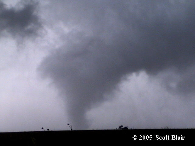
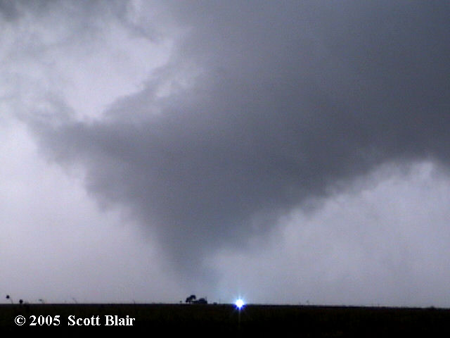
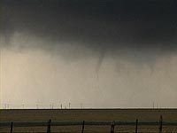
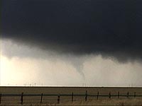
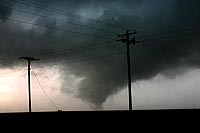
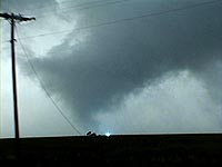
There were more storms along I-40 now, so we got on FM1062 near Canyon and shot W toward the most discrete and vigorous updraft in the tail-end Charlie position. We went N on US385 toward Vega with the intention of catching either FM1412 or FM2587 W, but we never turned W off of 385, because we found this instead:

http://community.webshots.com/album/78465099cfmXiq

Most of the vid was, and therefore most of the vidcaps were, taken from Floss' crappy vidcam, so the pics are pretty massaged for brightness and contrast, and also "Neat-Image'd". My "big" vidcam is just too bulky for full-time in-vehicle use. See if you can tell which vidcaps came from the "big" vidcam (XL-1).

I think we saw it on the ground for about 7-8 minutes as it crossed 385 going WSW(!), roped, and dissipated.

After that, we headed back S on 385, and a few miles down the road the local constabularies were in cordonation mode, so we stopped and chatted for a while. They only re-opened the road after getting my analysis of the situation (that further tornadoes were unlikely; that portion of the storm had gone OFD), LOL.

We let the shelf chase us into Canyon, where we stopped to eat as the sun set. It took too damn long to get our food, as it turned out (they were crazy busy at this Pizza Hut because of the WX...geez, what idiots order pizzas for delivery during t-warnings??), because when we finally emerged, we got blasted by another storm that I didn't wish to be in. We sat in the parking lot under a big tree (at McD's across the street) hoping we didn't get baseballs or worse. I kept d/l'ing data, finally relieved when I determined the meso was about 5 miles to our S. We shot a little flood vid before hitting the road to AMA for the night.

Kudos to Bill Robertson for nowcasting!

Bob
 
Status
Not open for further replies.
Back
Top