6/10/06 REPORTS: NE/WY/SD/CO

Joined
Oct 25, 2004
Messages
575
Location
Tucson, Arizona
Finally washed the '06 curse outta' my hair!! Started the day in O'Neill, Nebr. at my cousin's horse ranch, then got on the road towards the Neb. panhandle around noon. Figured that I was wayyy behind schedule and that I'd run into a big MCS by mid-afternoon. I've been so beat-up and bloodied by the '06 Curse that I didn't even feel that I had to drop the hammer and speed westward...as "what's the use, anyway?"
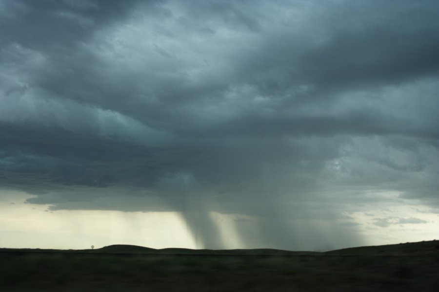
As I exited the west side of Gordon, Nebraska, I ran smack dab into a line of storms....and man, were the clouds pitching wildly. The shear was incredible, however no wall clouds were forming, and I just about said to heck with it and return to driving west some more. But something told me to stay put....that the insane amount of shear I was witnessing and the low level of the bases was reason enough to follow the line and continue watching. When I was approximately two miles east of Gordon....it became tornado city. Tubes began breaking out on both sides of Hwy 20...this would have been approx. 4:25 central. On the north side of the road...inside a rotating rain curtain....small tubes from a weak multi-vortex danced around another briefly at the surface. However, at the same time I had the most gorgeous long thin tube on the ground that I was filming on the south side of the road. This particular tornado lasted almost 8-10 minutes. Once it lifted, I followed the line further east...catching it in about 10 minutes. On the north side of the road now, many different tornadoes were touching down independently from each other. I drove up onto some old ranch road and filmed what I could, and took digital shots as well. I'll post these when I return back to my home in Tucson on Wednesday. All in all, this little outbreak lasted around 35-40 minutes. Man...do I feel better now. This day will give me the grins and ease my pain until Chase '07. Whew!!
 
No tornadoes spotted by me today :( . Getting used to doing that though. Congrats Joel. I guess I should have followed you after last night.
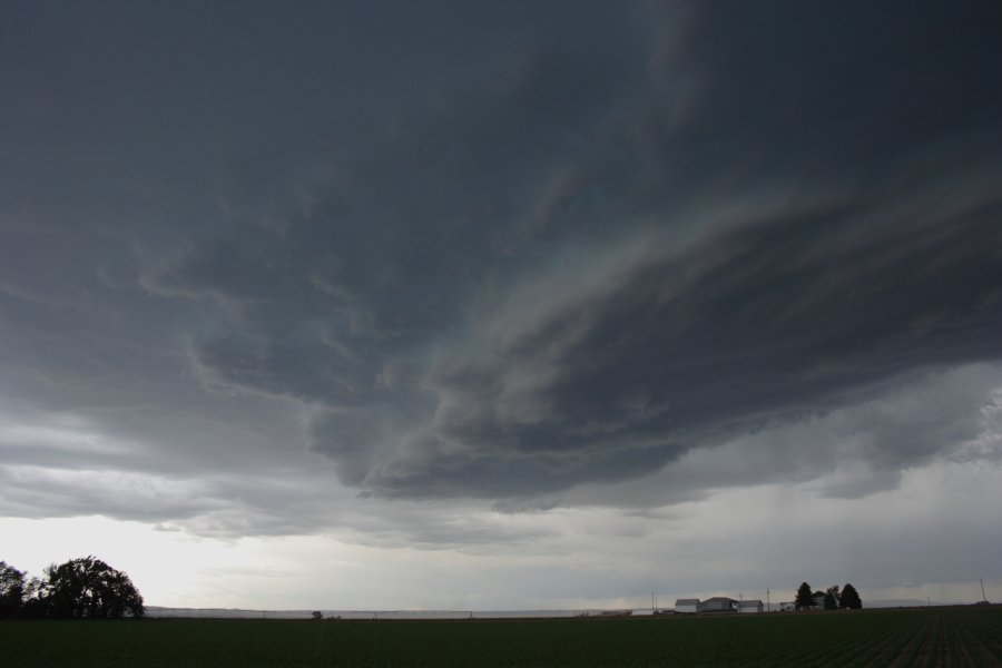
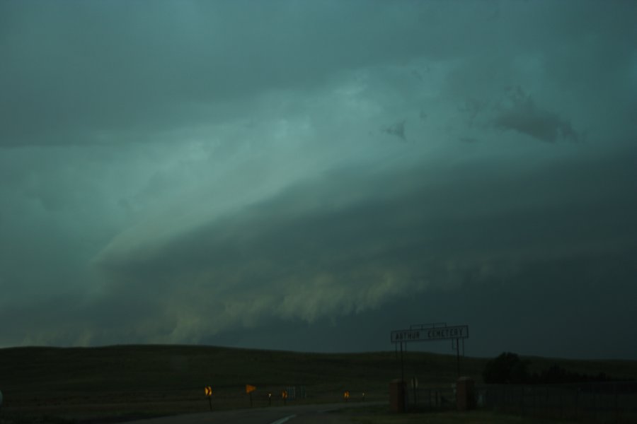
Got to the Sidney NE area as the tornado warned storm to the north continued moving east into no road land. If I wanted to catch that storm it would have been pretty impossible from this location. So I waited on stuff in se WY hoping it would do something. Cheyenne's radar being down didn't allow me to see what I was even missing on radar anyway. That sucked as much as it was nice though.

Not long after getting there the CO storm of the day fired to my south a ways. I could have interecepted that one pretty easily. I remembered the upper jet nosing in there and liked the area north of that storm better. I figured it would move east right into its own precip. You could see how the anvil was going more east on the radar. I thought about it a good bit and finally said no, not going to do that as I know that storm is going to crap doing what it's doing. Well I thought I had won that game for a good bit till it turned right....oops. Often if the moisture isn't the greatest it's hard to get something to turn right. I haven't heard much about that storm but I imagine it struggled for a good while, but bet it probably had nice structure when it finally did turn.

West of Sidney the ones coming out of WY started to get a bit more active. Their rfd's seemed pretty intense as there were constantly big dust plumes around them. It as giving me hope as they'd be getting more and more into the better dews to the east and also being located closer to the front left quad of the upper jet.

I headed east of Sidney and the rfd fun started to get a bit wild. This is where the report of the semi blown over east of Sidney was. I was zoomed in on the interstate as dirt was racing south across it very fast. Traffic would sort of dissapear into that mess. I left when the first gust hit me since I figured this dirt would screw up the interstate fast--I wanted to beat it east obviously. It really seemed to leap east from here on out.

I met up with Bob Schafer right before that happened in that spot. Bob had left east a bit sooner than I did. I fly east as crap is flying across the interstate and try to get ahead of it. After several miles I get ahead of the dirt and stop at a rest stop. There was Bob again. We quickly left there as it was to that location almost the same time I was. The rest of the chase consisted of a few very brief stops on I-80 as dirt hell was plowing east. We did 80 the whole time to the Sutherland exit and it pretty much stayed with us the whole time. It was hard to get a lot of shots after I left the very first spot at Sidney. Part of the problem was that cell to the north was now leaping se towards us as we went east. I feel pretty confident saying there was no torando at Roscoe like on the spc reports page. If I had to put my own money on it I'd say I was 98% sure there's simply no way. Might have beem some vicious dustdevils in there but not thinking anything tornadic.

At Sutherland I "met" up with Steve Peterson. Bob let me go back to the west an exit and I'm not sure where he went. I imagine he found some high winds if he stayed there as that might have been the Roscoe exit or Paxton. Went south at Southerland and got some structure pics. It was still pretty intense and displayed some nice structure. It weakened pretty fast at this point.

All in all a pretty exciting chase. During it I was having as much fun as I've had on any chase this year. I only wished I had let it overtake me at its last worst point, Roscoe. That is a tough balance when you are trying to get east of it incase it takes on insane structure. I always try and get both and most of the time when I decide to let it overtake me is when it weakens. Images will be posted whenever I get back home.
 
Thanks to "H", I don't have to explain where I chased and what I saw much! Thanks, Mike! :lol:

Here are a few pics, though...

The dust:


(click to view larger versions)


(above pic has window reflections)


Of course, H will post his pics, and they will be so much better than mine that nobody will believe we even chased the same storm, hahahaha.

I went S once I got to Hwy25 to see if the storm might attain some sort of new life upon getting into some better juice, but it didn't. I checked into a motel in McCook, then went to a restaurant for BBQ where I sat at a table with lots of window and watched the storm dump copious rain on us. Small hail and pretty good lightning added to the dinner show.

Now I sit here until at least Monday afternoon, because I gotta get my u-joints replaced. (and they were new last year. WTH.)

And, yeah, congrats, Joel!!!

Bob
 
Good evening,
We were on the NE Colorado storm. Very frustrating in the beginning. Lots of rain, mess everywhere you looked. Kinda regreted there for a while turning away from NE Panhandle storms. But then, everything changed. We were right under the meso when it got together and the cell took a right turn. Then we followed the supercell till it fell apart later in the evening. Lots of anvil lightning strikes that happened so fast so close you almost did not want to get out of the car. Saw Tony L. and his van passing by heading south toward the interstate :) . With the late afternoon the lighting conditions became quite bad so we drove further south to get a little further to grab some lightning shots but by then the storm was pretty weak. Staying in Colby, KS for the night and tomorrow's setup. Been here in the Plains for almost two weeks, several grand gone and this finally made the trip. Will be around for another week before heading back home to Florida for the hurricane season. I know there is a lot of chasers that made their trips this year that had to literally go back home with nothing. It is just sad. Somebody's luck/happiness always means somebody else's less fortunate outcome of things. Let's hope the rest of the season can bring more similar days and that things will be different (much better) in 2007. Good luck out there.


Complete account with our photos from the begging to the end here :

http://www.floridalightning.com/Midwest_2006.html at the bottom of the page.


Martin Kucera
FloridaLightning.com
 
Started the day near Denver, and decided to head North to Cheyenne, WY. Saw this cell go up around 11:30 just over Chugwater WY.

IMG_2409.jpg


Got to Chugwater, and followed it east on Hwy 313 where it seemed to struggle a bit.

IMG_2412.jpg


As it moved into Goshen County there were some great landscape shots... very pretty out there.

IMG_2413.jpg


Just east of Hawk Springs near the NE border, as it headed towards Scottsbluff / Gering. It was at this point I did see some rotation, but it only lasted a few minutes or so and it was tor warned at this time. As it moved towards Gering, I did see it kick up a lot of dust, as it started to gust out.

IMG_2414.jpg


Sitting in Gering as the line overtook me. It was amazing to see the speed at which it passed over me. Winds were probably 60mph+.

IMG_2415.jpg


After I let the line pass over me I tried to get south to see if I could get to the tail end of the line. At Burns WY, I hooked up with 80 east, and basically played catch up, but it was not to be, as they closed eastbound 80 at Sidney NE because of the overturned semi.

All in all a good day. Very pretty landscapes out there in Western NE around Scottsbluff.
 
This was one hell of a long day. Started the day in Scotts Bluff - metup with Scott Blair and Eric Nguyen. We intercepted tornado warned supercells - we even heard sirens blazing in Authur.

The first supercell developed in eastern Wyoming and drifted towards Scotts Bluff. This became tornado warned as it organised near the city. I filmed excellent timelapse of the mesocyclone. We headed further east and all I can say is Wow!! The circular structure was magnificent - high contrast and with green tinge!

0610jd25.jpg


0610jd27.jpg


0610jd30.jpg


0610jd40.jpg


This storm gradually lined out and we headed east for a developing supercell but the immense distance and lack of road choices (including a wrong choice) cost us getting much ahead of it to see any funnels and the main mesocyclone. We did get glimpses of it as well as timelapse of an approaching mesocyclone north of Authur. The anvil lightning and bolts were incredible. We saw a small grass fire that had been started by lightning.

0610jd49.jpg


0610jd53.jpg


0610jd68.jpg


0610jd74.jpg


Finally the last attempt to get decent structure had to wait until we got to North Platte.

0610jd77.jpg


From here we decided to cross the border - not before getting hammered at McCook during our meal - some excellent footage of blasting winds and rain - only small hail though. Lightning was as per normal very frequent but some explosive thunder within the core near Hoxie.

Regards,

Jimmy Deguara
 
Nice to have at least one good day on a weeklong trip. I guess that's alright by Year Two Thousand and Sucks standards.

Drove from Norfolk to Ogallala for data with the preliminary target of Scottsbluff via HWY 26. By the time we got to Bridgewater for more data, we could see the circular base of Storm 1. We drove north on HWY 385 but at this point a) we were more or less cut off by the precip shaft and thought trying to punch for Alliance was a bad idea, and B) Storm 2 had shot up from nothing just east of 385 and was commanding attention. It had a reverse horseshoe base which perplexed me, but it got the TIV crew shooting down 385 back onto 26.

We pulled off the road north of Bridgeport to watch out first storm, or Mistake Number One. Nice footage of our base being demolished by RFD but no spin. Meanwhile Storm 2 did not look all that great from our vantage point but was probably merging with a third cell we could not see and later became the TOR warned cell. At this point the Cheyenne cell has taken on a bow appearance and is coming after us from the west.

So: we are blasting SE on 26 with a TOR warned cell to our north and a mean green downburst machine on our tail. This was Way Cool.

We slowly gained on the TOR cell and put some distance between us and the bowed out storm. However, we then got to witness the bow catch up and merge with the back of the supercell. Wow. We saw an amazing convergence cloud structure, like a foot, very near the ground in the area of storm merger north of Broadwater (where the road turned to dirt, south of Dogtown Flats which was in the TOR-warned area).

Raced ahead of this increasingly shelfy and beautiful storm to Lake McConaughy. Our original plan was to go north on HWy 61 and try to see the tornadic area, but the abundance of TRAINS that afternoon made us jog south of the tracks to ensure we were not trapped. We pulled over after crossing the dam road and took shots of the storm coming across the lake. Green on Green. Just amazing.

Got rained on on the way to Ogallala and then considered racing south to get the CO cell, but it had caught up to the line at that point, so we decdied against fifty miles of rainy driving and stopped for the night in Sterling.

So, despite being thwarted AGAIN by the Sandhills on the same day in about the same place as two years ago, like two years ago it was still a great chase day.
 
Quite a long hall as Sean, Katie, Jeff and myslef made the long hall out West after chasing the NW Iowa junk Friday. The whole way down I-80 we debated rather to play with the stuff that was begining to bubble in NE or wait to see if the WRF would varify and we would then need to drop south into NE CO. After stopping in North Platte and driffting west we got word of the Tornado Warning in the Scottsbluff vicinity, not knowing what the storm looked like due to Cheyenne's radar failure :rolleyes: 
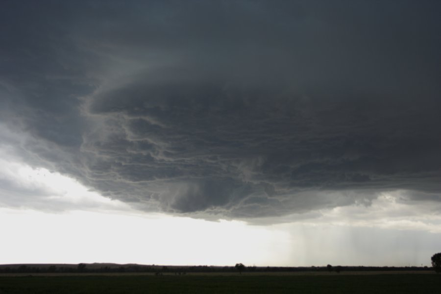
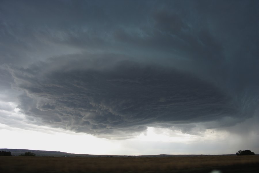
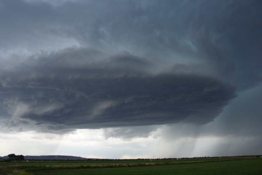
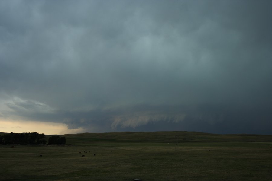
we decided to at least go check it out, upon arrival we did not like what we saw mainly a high based outflow look to the storm and about this time showers where begining to develop over Denver. So we opted to drop south and keep our faith in the WRF, glad we did as on our arrival to the storm it grew emmensly. After thinking the storm was looking like it was gonna go bonkers it began to look like it was loosing its updraft , but boy this upslope stuff can quickly evolve as Tony Laubach reminded us; after looking weak it quickly regenerated and formed the neatest RFD I have ever been in. The view from the North of the RFD was cool but once we drove through the RFD dust and got to the South Side :eek: we were treated to an amazing show.

Here are some video grabs, please keep in mind video grabs do not do this storm justice esspecially from my low end camera.

http://s66.photobucket.com/albums/h260/dwu...nt=e230cd66.jpg
http://s66.photobucket.com/albums/h260/dwu...nt=25665292.jpg
http://s66.photobucket.com/albums/h260/dwu...nt=4f15a103.jpg
http://s66.photobucket.com/albums/h260/dwu...nt=dd466292.jpg
http://s66.photobucket.com/albums/h260/dwu...nt=5090cdf5.jpg
http://s66.photobucket.com/albums/h260/dwu...nt=5a678b21.jpg
http://s66.photobucket.com/albums/h260/dwu...nt=936453fb.jpg
http://s66.photobucket.com/albums/h260/dwu...nt=9e74ce68.jpg
http://s66.photobucket.com/albums/h260/dwu...nt=23a68593.jpg
http://s66.photobucket.com/albums/h260/dwu...nt=c544de73.jpg
http://s66.photobucket.com/albums/h260/dwu...nt=c890fb68.jpg
http://s66.photobucket.com/albums/h260/dwu...nt=21e282aa.jpg
 
COMPLETE JUNE 10, 2006 STORM CHASE LOG CAN BE FOUND HERE!

Congrats Joel on your catches... looking at that line of crap, I was amazed to see such reports. I'm anxious to see your stuff later.

Mike, you did miss out. This was a classic Hollingshead storm! Chris Rozoff, Matt Kassawara, and myself got it just before it split and on radar looked like crap. In fact, had we not been on it at that point, I would imagine we would've bailed on it, too! Glad we didn't as it became the best structure storm of 2006 with no doubt. We stayed on it from roughly Woodrow all the way to Kanarado where we let it dump its nickels and rain on us. Insane structure on this storm and incredible low level rotation would've produced a big tornado had the LCLs managed to come down. The storm did lower as it moved east, but couldn't quite bridge the gap. None-the-less, we drooled over this structure for a couple hours. We had a good show of RFD dust near the town of Cope on Hwy. 36. Definately the best storm of the year for structure so far.

COMPLETE JUNE 10, 2006 STORM CHASE LOG CAN BE FOUND HERE!

060610b.jpg

Eddies in the striations of this storm near Cope.

060610d.jpg

Accidentally bagging a lightning strike at 60mph near Cope.

060610o.jpg


060610n.jpg


060610j.jpg


060610l.jpg


We're heading back to Ft. Collins so I can drop off Matt and Chris, then I am heading home for the night to prepare for tomorrow. An excellent Colorado storm today!! What a beauty!

COMPLETE JUNE 10, 2006 STORM CHASE LOG CAN BE FOUND HERE!
 
Back
Top