5/9/06 NOW: OK/TX/AR

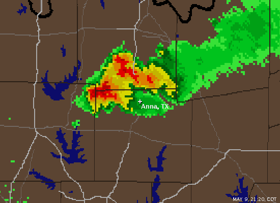
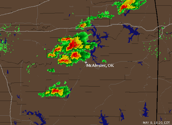
Significant tornadic event beginning to rapidly unfold across eastern portions of Oklahoma, including the McAlester area. Storm moving towards the Fort Smith area has a pretty classic flying eagle radar presentation. Boy do I wish it weren't finals week!

060509a.gif


EDIT: also TOR-warned storm near Iowa City, Iowa has a spotter-reported funnel cloud associated with it as of the latest SVS at 730CDT.
 
Perhaps now would be a good time to change the title of this thread to reflect the full impact of the severe weather threat.... This system is actually affecting OK, TX, MO, and AR.

Also, i would be careful to call this a major tornadic event as there does not appear to be any storms with confirmed tornadoes at this time. One supercell with a decent hook for quite a while now, but haven't seen any reports from it.
 
4.5" hail reported in the east Tx panhandle south of Shamrock near Samnorwood in Collingsworth county. Also baseball size hail now heading directly at Childress.

No tornado warning on these so far but they will move into better shear in Oklahoma
 
Sitting here in Antlers on the Indian Nation Turnpike.........was one the Coal County/Atoka County storm.......if you can call it that........now I know why they call SE OK the jungle. Got a good look at a very nice wall cloud near Atoka.........but after about 5 minutes of viewing it the storm passed over some hills and trees and that was that. Oh well.....didnt expect much today. Raining like heck here in Antlers and looks like it will be for some time as this line is barely moving.
 
Jay:

I just noticed that 4.50" hail report as well. It sure does look like those 3 apparent tornadic supercells in the far Eastern TX panhandle are the best show in town right now. 10-15 minutes of golfball to baseball sized hail near childress. Ouch!! Anyway, those storms sure look like they mean business and they also look very capable of producing tornadoes anytime now.

0905 PM HAIL SAMNORWOOD 35.06N 100.28W
05/09/2006 E4.50 INCH COLLINGSWORTH TX LAW ENFORCEMENT
WINDSHIELDS BROKEN OUT


EDIT: I am baffled that the 1 supercell is not tornado warned. It is exhibiting intense Gate 2 Gate shear right now and one heck of near perfect hook.
 
tornado being reported on the ground IN the city of Childress by Jason Boggs and Matt Hines. Apparently it is moving through tghe north side of the city. Multiple power flashes and backlit by lightning. Warning has just been issued.
 
tornado being reported on the ground IN the city of Childress by Jason Boggs and Matt Hines. Apparently it is moving through tghe north side of the city. Multiple power flashes and backlit by lightning. Warning has just been issued.[/b]

OH NO! according to the latest LSR, significant damage was done to the city of Childress (pop. ~6500) by this tornado. looking for more information now.

http://kamala.cod.edu/offs/KLUB/0605100301.nwus54.html
 
This hurts to watch. I conceived saddling up and riding out that way when I watched that tower blow it's top earlier on this evening. I had a feeling in my gut. Nothing else to contribute except the warning is reissued and the hook is hugging 287.
 
Tornado on the ground with the Collin County TX storm as of 1029CT; power flashes just north of Anna. SVS says it's heading toward Westminster.

060509anna.gif


New warning for the adjacent county related to this cell -- spotters reporting a large tornado on the ground 5NE Anna.
 
Just got off the phone with a friend in NW Anna, no damage to the town that he could see.
[/b]

Good that it didn't make a direct hit on Anna as it sounds like it has gotten quite large just northeast of town.
AT 1039 PM CDT...TRAINED WEATHER SPOTTERS REPORTED A LARGE TORNADO 5 MILES NORTHEAST OF ANNA...MOVING EAST AT 10 MPH. THIS TORNADO WAS PRODUCING DEBRIS.

EDIT: and a new blue box is out for central and south okla and NC texas.

EDIT2: according to the LSR, the original tornado near Anna had dissipated and the reported large tornado was a seperate one.
 
The storm that moved through Childress earlier and now located in WILBARGER COUNTY Tx is really looking impressive. The storm is the southern most storm and has unobstructed warm inflow to work with. If it stays at the current track it will be making a line straight towards Wichita Falls. Hopefully these will squall out so we don't hear of any more damage, injuries or deaths tonight.

If I were chasing this would be the storm I would go after.
 
Collin County spotter reports home hit just now by tornado near Westminster on FM 2862. Occupants appear to be accounted for.

"Debris is everywhere." another spotter just says.

147.18MHZ is getting out there tonight... I'm 100 miles away and it's S9. If you're in the vicinity, you might tune it in.

EDIT: Storm hit about 1045CT.

Spotter reports funnel lifted at 1055CT, lowering remains.

NEW: 1108CT. Red Cross mobilizing, and net control getting spotters to Westminster and Anna for possible coordination of disaster relief. Spotter reports numerous homes struck.

1110CT: spotter reports two homes leveled near westminster. One other has walls still standing.
 
Back
Top