5/23/05 REPORTS: PLAINS

Status
Not open for further replies.
Joined
Sep 17, 2004
Messages
1,195
Location
Bangladesh
After a quick morning anaylsis I decided to make the last minute drive to SW NE. I left at 9 am. I was pulling into McCook, NE just as things got going. Went to intercept the cell in Yuma. Arrived in Saint Francis along with several other chasers and the rotate team. Wasn't terribly impressed with the cell. After following it for a while another svr warned cell came through and followed that back to Burlington. Some decent structure shots and a great lightning show.

-Scott Olson
 
I started the day in Goodland, Kansas. the forecast was difficult since the best moisture was to the south while the dynamics were northward. I initially was thinking the Yuma area but wanted to check more data. I headed west and stopped in Seibert for lunch. To the southwest, I observed an area of Cu by 11:20AM. The sky was clear otherwise. I continued west and watched this area consildate into two highbased storms. When I reached Limon, the stormss began to consolidate and the bases lowered. there was a hint of a wall cloud. I headed southwest on 24, meeting up with Jason Persoff, M.D. in Calhan. The vault was almost overhead and the area was pelted with some small hail. We had to head south before the storm became stronger. We reached 94 and turned east. The storm was to ournorth. It developed one main updraft, hail core and some lowering of the base. We barely passed it before the hail core reached the road. There was a wall cloud to our east but no further development. We ran into Scott Blair and the WeatherVine group while watching the storm with mid level rotation. The wall cloud continued. The storm looked good but then began to die as a another storm formed to the east. Jason and I drove north to intercept the tornado warned storm to the north; however the storm merged into a big complex with other storms. The chase was over. I did try an intercept the storms north of Berlington. As darkness arrived, one storm just north of Berlington briefly developed some rotation and inflow. The day ended at Pizza Hut in Berlington, Colorado.

2:30MDT near Rush, Colorado on 94
temphailwall052305.jpg


Other Images

Development southwest of Limon, Colorado, 12:30 PM MDT. Image taken from east of Limon
http://www.harkphoto.com/tempearlystorm052305.jpg

http://wwwharkphoto.com/temphailshaft052305.jpg

Bill Hark
http://www.harkphoto.com
[/url]
 
Verne, Katie, Allen, Jon, and myself intercepted the Palmer Divide storms south of Limon; we danced around with those a bit near Kit Carson after briefly meeting Gammons and crew. We elected to repunch the storm from the south and stopped in Kit Carson to talk to Tim Samaras for a bit before shooting north into Burlington. We intercepted the storms north of Burlington and got blasted with 60+ mph winds, some small hail, and some pretty freakin' heavy rain. We returned to Burlington and filmed around town before Verne and crew split back for Denver while Jon and I dropped just south of town to film lightning for a bit before making our way back home. I ran into several people out there today, and my apologies for the quick intros. You guys really need to find me when things aren't going on cause it seems like everytime I meet someone from here, I'm in a hurry! I feel like such an ass! *LOL* Believe me, its nothing personal, but Nature doesn't seem to hold up for intros!

Anywoo, good day to play in Colorado today... ran another 550 miles to my growing total which puts me at over 6,000 since May 10! More to come this week, too!

[Broken External Image]:http://www.tornadoeskick.com/images/050523a.jpg
Lightning photo from the storms north of Burlington, CO at sunset.
 
We targeted Kit Carson, CO, today as the likely intersection of initiation off the Rockies with the good moisture. Coming up from Lamar the warned cell moving southwest from Colorado Springs was the obvious attention-getter, but the new cells going up to the northeast along the dryline/front were bubbling well with nice, flat bases and some visible rotation in the updrafts. Along with several other chasers we started west toward Punkin Center and took to the gravel roads while we decided what-the-heck was going on.

The original cell looked less and less impressive and choked in 40 degree dewpoints. The tail end wasn't working according to the book and was mostly outflow even though ingesting 60+ dews on 15kt southeast winds. The Yuma County hailers had great looking flanks but were backbuilding into crud -- go figure.

So we circled back through Eads and eastward to Brandon, where Dean the Storm Guru pondered for awhile. Between the dryline/front pushing southeast and the dying left-mover up from La Junta was clean, moist air; and a disturbance was riding in firing cells off the mountains. Lamar was in the middle.

Sure enough as we headed back down toward Lamar, the cells coming from the west remained discrete and started liking the environment with meso indications and 1 1/2" hail. Several rain-free bases in the string had visible areas of interest. We cut west on CR 196 past McClave. Past McClave we clearly saw several funnel clouds in the approaching meso. We set up for pictures north of Hasty with a clear view to the west, backlit by the setting sun, and two horses preening and posing for us. The meso tried, with another funnel cloud before it began to wain in favor of the sister to the south.

We moved south atop the John Martin Reservoir Dam where we could see just about forever to the west, taking pictures of sunset, water, mesos, etc. Only thing missing was a tornado, but with a gorgeous setting like that, it made up for the previous days of coulda' been, shoulda' been cap.

Heading back into Lamar we were treated to CGs and marble hail. All in all, a good day! :D
 
What a day !!

Rolled south out of Julesburg around noon ? Mountain time and Central time have me all confused :eek: . Target was Wray but stopped to watch the storms roll of the front range and found some dat in Holyoke. Cu starting to develop to our south and I did not know the nature of the front range stuff to know if they were worth chasing. So onward to the target area. Hit Wray around 1:00 or perhaps a little later. Stopped to get data and ran into the TIV and the DOW crowd, small world. Picked a target largely by looking up. The radar was 15 minutes behind and things were going up fast. Headed south out of Wray CO towards Vernon.

We parked under what seemed to be the nicest cell and waited for it to develop. This storm just stayed put, inflow got pretty nice and we had decent NOAA radio and we were under it as it got tor warned. Picked the wrong side of the inflow arm and as the storm started to dump hail we got chased out of there. Nickel sized hail for us that is plenty big !.

Ended up under the next cell to the west. This one was building too, dropped a nice wall cloud and really seemed like it was going to happen. Then it faded and then dropped another wall cloud. Once agin the rain and hail chased us out into wray. That storm was also tor warned I believe.

The whole thing was growing into one big MCS and we hit Wray again for data. Targetted a sev warned storm that was the last in the chain and got behind this one and out of it's way. Found the inflow and followed it for about 45 minutes and ended up in Idalia for sunset. Nice rainbow.

Man the inflow on that cell was insane, howling winds, clattering thunder or hail, obvious high winds not too high above. Never developed any real serious rotation. Followed it till it raised up too high to bother.

Found ourselves in Idalia and headed south to Burlington. Ran into Tony and a bunch of chasers in Burlington. Tony was busy but we interupted anyhow. :D

Fun day.

--
Tom Hanlon
 
We target NE Colorado. We ended up in Kit Carson, County. Got to see some pretty good structure. Storms went linear real quick. We intercepted several storms. Bases were a little high. Got to see a couple wall clouds and perhaps a funnel. Ended up driving over 900 miles to the target and back to Wichita. Got home a 1am.
 
I had passed on a tornado report as issued by SPC in Kit Carson - but it was cancelled minutes later by them
- sorry about that -
great pics you guys got though!
 
A little late on getting this report posted, but at least I got it done...

Scott and I woke up this morning in Dodge City at the Super 8 Motel. My alarm clock didn’t go off so we got a late start to the day. Our initial target area was about 70 miles west of Goodland KS. We left Dodge City around 11:00 AM CST. We made some time from Dodge City on some very rural Kansas highways. We were in contact with several chasers through the day exchanging data, information, and target areas.

We made a quick food and data stop in Goodland KS. Scott and I decided to continue west on I-70. At 2:20 PM MDT a tornado watch was issued for our target area. To our west there were towers going up, so we decided to top off the fuel tank. We stopped in Stratton, CO for more fuel and data. While checking the internet we were able to watch some towers punch through the CAP along some sort of boundary. No need for us to travel much further west at this point.

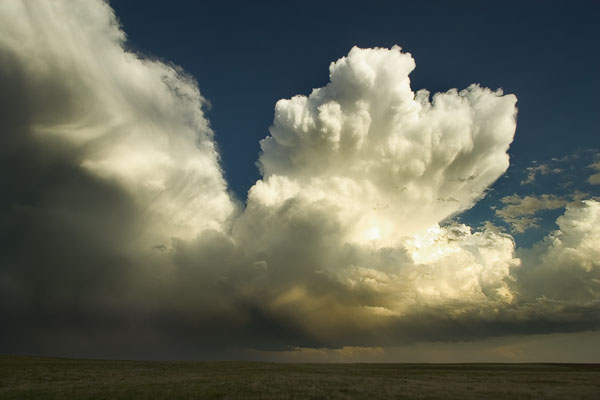
There was a storm that developed about 10 miles west of Stratton, CO that we watched for about an hour. We hung around the area for a while taking pictures and videos of supercell bases. There really wasn’t anything too exciting happening yet though.

We then heard of a tornado warned cell off to our northeast. It was about 30 miles away, so we decided to intercept it. I am very impressed with the road network in eastern Colorado. The only problem is when the dirt roads get wet. They can become sloppy and slick in no time, so 4x4 was really useful on some roads. Not because I was going to get stuck, but because 4x4 offered much more control than 4x2 did.

As we drove north on a county road that south from Yuma Colorado we could see the wall cloud in front of us. Scott and I were getting pretty close, so I pulled off the paved county road onto a dirt road. I bet this is one of the only dirt roads that have two sets of power lines running down it. I might consider being near 1 set, but 2 isn’t acceptable. We went north about another mile and pulled off onto another dirt road near Beverly Grove.

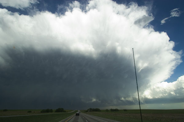
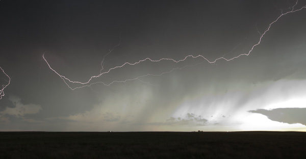
We could clearly see a rotating wall cloud so Scott and I scrambled to get our camera equipment. Shortly after setting up the cameras we saw the RFD punch through just northwest of the wall cloud. When viewed from the video, you can see that the RFD cut under the wall cloud and shut down the inflow. We are facing east while taking the video.

At this point the storm became outflow dominant and we had to keep running from the RFD. It was blowing dust and grit several hundred feet in the air. I began to get frustrated since I couldn’t get any data or cellular service. We found some chasers (Mark and Fabian) at a grade school checking out the sky. We teamed up with them and headed south so we could get a cell signal. While heading south towers started going up all around us. We had to shoot south to Stratton to avoid a hail shaft. Mark was able to get a cell signal and started using radar to guide us. We then jumped on I-70 east and exited a few miles away in Bethune. From there we went north to investigate a supercell Mark saw on his radar.
We stopped about 10 miles north of Bethune, CO to watch the storm. It was starting to get dark so our visibility wasn’t the best. Mark and I decided to drive east on a county road to avoid the hail shaft. This was the closest I’ve ever been to (what appeared to be) at least golf ball size hail. The outflow winds were kicking dust and dirt all around us. I wanted nothing more than to get out of there! Luckily there was a pretty good road network and we were able to go south to Burlington, CO. On the way there Mark was closely watching the radar since almost everything had gone linear. To avoid the large hail we went about 3 miles south of Burlington to wait it out.

We spent the night in Imperial Nebraska since our target area was further north tomorrow.

You can find my entire chase report on my website. I have 1 video and 23 pictures you can view.

http://www.brademel.com/pages/storm_chase_...year=2005&id=13
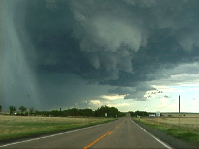
 
I finally uploaded pictures from 5/23/05 today so I figured I'd post a chase report along with them.

Geoff Fink and I began the day in Grand Junction, CO with absolutely no intention of chasing. We had been driving for 2 days straight from CA for our annual chase vacation. We were aware of the severe threat for 5/23 in eastern CO, but with a similar setup forecasted for 5/24, we were planning to take a break and visit Arches National Park in Utah. Around 1:00 PM and after looking at the rather depressing outlook for later in the week, we decided to book it east instead. There appeared to be only a few potential chase days coming up, so we decided to make the most of it. I-70 between Glenwood Springs and Denver must be the most spectacular section of Interstate in the country. We arrived on the west side of Denver around 5:30 MDT and checked data from a hotel parking lot. Initiation had already occurred over the front range and high plains, and storms were beginning to congeal into a MCS to the north and east of Limon. However, considering this was the first day of our chase trip, we were severe weather-deprived and continued east anyway. Just east of Aurora we encountered some heavy rain and very small hail, but the southward curve of I-70 led us out of the precip.

I70east.jpg


We parked alongside a dirt road south of Limon and observed the cells to our north and east. The MCS was now well into Kansas and the dryline had moved through, however there were several high-based non-severe cells behind it. With sunset approaching, it made for some nice pictures. Surprisingly, we were able to watch a new tower go up immediately to our south. Though it was far from severe, it was still quite photogenic with the sun so low in the sky.

newcell.jpg

newcellvert.jpg

mammatus.jpg

sunset.jpg


After the sun set, we attempted some lightning photos with moderate success.

lightning.jpg


The scare of the day happened when we were driving along a dirt road after finishing taking lightning pictures. Lightning hit one of the power poles behind us (within 1/2 mile), and caused a shower of sparks to fly out of a transformer that was right next to the car. It made us really thankful that we had decided to stop taking photos 2 minutes earlier!

We stayed at the Comfort Inn in Burlington in preparation for the following day. We saw a few other chase vehicles in the parking lot but since we arrived fairly late at night, we didn't run into anyone.

All 107 photos are at

http://www.mikeroburst.com/cgi-bin/emAlbum...%20Eastern%20CO
 
Status
Not open for further replies.
Back
Top