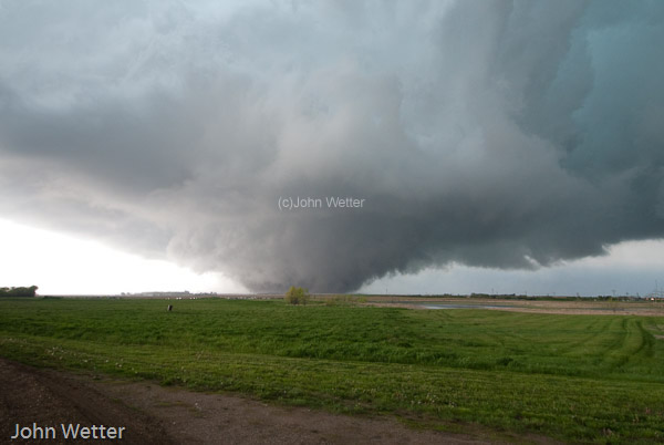
5/22/2010 REPORTS SD

Not much to add to what has already been a well documented storm.

Here's a video of the Bowdrie wedge just as it about to skirt the town:

http://www.youtube.com/watch?v=HS-CmtpPvb0

The storm was definately by far the best I've seen on my yearly chase vacations going back to the mid-1990's.
 

Attachments

  • P1010678.jpg
    P1010678.jpg
    8.1 KB · Views: 236
  • P1010714.jpg
    P1010714.jpg
    9.7 KB · Views: 237
  • P1010774.jpg
    P1010774.jpg
    7.4 KB · Views: 228
  • P1010743.jpg
    P1010743.jpg
    9.9 KB · Views: 226
  • P1010686.jpg
    P1010686.jpg
    8.4 KB · Views: 226
Last edited by a moderator:
I finally processed my photos and just finished writing up a blog post. Don't feel like downloading more photos or writing more words. Suffice it to say that I'll never forget this chase. The storms were amazing, the ordeal in the field was first horrifying and then just plain miserable, and overall, May 22 is something I'm delighted to have experienced, though there's a part of it I would never want to relive.

Great photos, everyone!
 
Lots of shots from underneath the storm... Here's what they looked like from another vantage point:

IMG_2650c.jpg


IMG_2670c.jpg


IMG_2654c.jpg
 
Not much to add, but figured I'd share the few shots I got that haven't already been replicated 10x by others. I had a great, close-up encounter with the first tornado as it crossed SD-47, but as a consequence was among the unlucky group who took too long to get N to US-12 to obtain a rain-free view of the wedge (thanks to SD-47 being blocked). The cone beneath a perfect mothership SW of Hosmer later on is a scene I'll never forget.

First tornado just W of SD-47:
4642153915_72c532cf83.jpg


E of SD-47 with vertical wall on the backside of the RFD:
4642766670_2ce625c0b1.jpg


Bowdle wedge from the SW (hey, at least it's a unique view :rolleyes:):
4642154137_5c7669a51c.jpg


Cone SW of Hosmer:
4642766818_e75f7cf366.jpg


Structure from near Hosmer after the cone, looking SW:
4642154905_a904871aef.jpg
 
Following a late night finishing business I left home Saturday morning at 7 with little sleep, a big thermos of coffee and a long drive ahead of me. I estimated I could hit my target area of Vivian, South Dakota by 4pm if I hauled ass and would be in place to make adjustments before the storms fired. I was partly correct as I made the target in time but looking to the north I could see TCU that appeared approximately 100 miles away. It barely registered on radar and after analyzing data decided to make a play for it as the cap was a concern and nothing else of substance appeared to have initiated. Even though forecast soundings showed CINH diminishing and models showed the cap eroding I still had concerns none-the-less and I wasn’t too thrilled with the prospect of the second longest bust chase of my life. I headed north on 83 and based on reports would have made the show from the start of the action if not for a navigation error that cost me at least 25 minutes. It’s a real kick in the pants to drive approximately 830 miles to catch a storm knowing 30 of those unnecessary miles cost me seeing a wedge! But on the other hand I feel fortunate to have made it all that way and still be in time to see a couple of tornadoes.

After correcting the navigation error I got under the meso in Bowdle by punching through the back of the hook on Hwy. 12. Actually it wasn’t a punch, it was more of a tentative crawl as I made sure I never lost a decent measure of visibility. Arriving in Bowdle the sirens were blaring and a large area of circulation was evident above town. Rain curtains started wrapping around a broad area and as I moved east to get ahead of the notch I was happy to note how sparse the chaser circus appeared to be. Then it occurred to me how things have changed; as short as six years ago I was stunned by being amidst a crowd similar to this size whereas now the throng seemed small by comparison to what I’m used to seeing lately. With little traffic congestion to deal with I was able to easily reposition ahead of the circulation in time to see the formation and entire life of a tornado just east of town that went through various shape/type incarnations: starting as a skinny trunk, developing to a small cone, evolving into a multiple vortex and then lifting before descending again as a skinny trunk until quickly roping out. It was then that a guy from Vortex 2 (he was chasing independent from them as the team was not active that day) came up to bum a smoke and asked me if I saw the wedge. “Wedge?†“Yeah, check it out†as he proceeds to show me a capture on his vidcam. I went from high spirits to a feeling of dejection realizing what I missed but it was short-lived; I was under an incredible beast of a storm, had just witnessed a nice picturesque tornado and wasn’t going to let what I missed detract from the experience.

I paralleled the movement of the storm eastward along Hwy. 12, staying ahead of the notch and periodically jumping slightly north on any paved roads to get a better view. (A note to those not on this storm that talk about viewing from a safe distance: This was an HP for most of it’s life and if you wanted to see a tornado you had to stay ahead of the inflow notch, any other position was for the most part shrouded by precipitation.) Just west of Ipswitch I witnessed the drill-bit that threatened the chasers stuck in the field. I wasn’t surprised to discover later that there were multiple tornadoes occurring at that time but due to my vantage point they were obscured. It’s satisfying to see verification of what you suspected through the lens of others that had a non-obscured view. I continued east on Hwy. 12 and made an attempt to reposition ahead of the notch near Wetonka via County Rd. 15. By this time it was getting dark and as I approached so too did either the core or rain wrapped meso; it was too dark to tell and too risky/foolish to try to race. With the only viable east option north of town (County Hwy. 23) and the unappealing prospect of getting engulfed by either feature I back-tracked to Hwy. 12 and called it a day. I ended up staying in Brookings for the night, completing a 17 hour, 1026 mile chase.

Video of tornado east of Bowdle including time-lapse of circulation immediately following the tornado:

http://www.youtube.com/watch?v=ih9cTQxOdXQ
 
Here are some of my pics from this chase. I've covered the field incident in other threads and video from the drill bit tornado onwards was very intermittent due to my concern with finding a way out of that situation. Regardless, below are images of the stovepipe, multivortex and wedge stages from south of the storm, and some shots of the photogenic cone and start of the brief multivortex from North East of the storm


IMG_0133.JPG


IMG_0135.JPG


IMG_0172.JPG


IMG_0210.JPG


IMG_0242.JPG


IMG_0255.JPG


IMG_0301 (2).JPG


IMG_0400.JPG


Here is the chase upto and including the nice cone tornado. Note that it is for the most part unedited, frequently out of focus, and has me mumbling to myself in the background but I'm so in awe of the storm I forget that I'm filming it ;) Might give some of you guys an impression of the storm from the south side although I'm sure others have already posted similar views... Being unedited, there's a fair bit of time when the tornado isn't visible (especially part 2, but it's up to you if you sit through it all ;) ) There may well be a part 5 if I can scrape enough footage from the field and dead end road but I think Adam and Ben's videos from that point on blow anything I could do out of the water!


This by far was my best chase EVER! I got off work at 6 AM and went to pick up my girlfriend, Lisa, than we were Murdo, SD bound. This was my first South Dakota chase and it didnt disappoint! This was Lisa's first chase of 2010, and she had yet to see her first tornado ever. When we got to Murdo, I noticed better dynamics coming together just to the Northeast, right northeast of Pierre, SD. We headed for Pierre and got into town right as I noted some cumulus clouds start to "bubble up" just north and northeast of town. I knew thats where we needed to head, so I got us to the east of it as it started looking very good. Got on the storm right as it was developing a wall cloud. We started to head north to HWY12, which was only about a mile or two up the road, right as we started driving, I told Lisa to look behind us and to the left, a funnel was starting to come down, and about 30 seconds later touched down. Lisa was pretty excited, as shown in this picture:
25z47rb.jpg


We than proceeded East on HWY 12 into Bowdle and decided to go north and wait for the tornado to come to us. This thing became a monster! Here's the video I shot of it headed right toward us and eventually we move just a bit south to let it pass by to the north.


We waited til it passed, and tried to get to the house, but there were power lines all over the road. We found out the next day that the people living in the house that was hit had seen the tornado coming and left before it hit.

What a day! This was by far my best chase and best/biggest tornado I have ever seen since starting to chase in 2008!
 
Last edited by a moderator:
My wife and I chased this storm and we would probably call it our best chase success to date. I don't think it gets any better than a monster supercell moving right along a well maintained highway and with a slow storm motion to boot. Anyhow, here are some of the video grabs I took. I'm still working on the video and will hopefully have something ironed out in a couple of weeks, but I'm a noob at You Tube so it will take some time. In picture order I call them: Open Wide (shelf cloud has teeth), Inverted Funnel, Manchesteresque, Cone Special, and Baby Parkersburg.
 

Attachments

  • Open Wide.jpg
    Open Wide.jpg
    8.2 KB · Views: 230
  • Look Out Above.jpg
    Look Out Above.jpg
    6.3 KB · Views: 228
  • Manchesteresque.jpg
    Manchesteresque.jpg
    11.9 KB · Views: 231
  • Cone Special.jpg
    Cone Special.jpg
    11.1 KB · Views: 226
  • Baby Parkersburg.jpg
    Baby Parkersburg.jpg
    10.6 KB · Views: 225
When we checked out of the hotel in Chadron Saturday morning, we had no idea what an incredible day this would be. Models showed the triple point positioned across north central South Dakota by afternoon with ample moisture, huge CAPE, and shear favorable for tornadic supercells. It looked like there was hope that the CAP would erode well enough to allow things to reach their potential.

As we headed north on US-83 at 2140Z, the cumulus field was starting to pull itself together and definitely looked like it was going to beat the CAP.

img2010052201_Cumulus.jpg


It was exciting to watch it grow and to realize that we were going to be in good position to intercept if it did explode. And it did! By 2215Z, it was pushing up a firm anvil, and by 2235, it was straight ahead, sporting robust inflow bands.

img2010052203_Supercell.jpg


Features under the base began to lower and take shape as we approached the junction with SD-20 where we headed east to get back ahead of the storm.

img2010052205_Funnel.jpg


Thirteen miles to the east, we turned back north on SD-47 and by 2300Z, we were watching a foaming wall cloud being fed by a well-defined tail cloud.

We found a pullout on the road and watched the majestic thing before us. As the meso approached, warm humid wind pushed hard against our backs, urging us to surrender to the storm's gaping appetite. A golden light seeped beneath the base and RFD began to stir up ragged masses of dust on the far side like a cage going up around the ring. The array of rising, rotating, intertwining structures had me completely awestruck--it made me think of a Grand Design spiral galaxy in fast motion, the monster at its core threatening to burst to life.

img2010052207_MesoPano.jpg


While the heart of the meso was on track to pass north of us, the growing rim of the toothy collar cloud looked like it was going to pass too close for my sensibilities, so we buckled in and headed south. As we drove, the south side of the meso began to drop and tighten up. We found another pull out about a half mile further south and watched as rain wrapped under the base, while the collar cloud arced onward.

img2010052209_RainWrapped.jpg


As the mist of precipitation cleared, the hulking mass of a cone tornado emerged from the shadows of the wall cloud (2315Z).

img2010052210_Tornado.jpg


As it slowly moved from left to right, the cone got fatter and then slowly pulled away from the ground, a pale uvula drooping from the singing mouth of the storm.

img2010052211_Tornado.jpg


img2010052213_Funnel.jpg


At 2317Z, the bulbous funnel re-formed a ground churning tip, like a hypodermic needle inoculating the earth. Within seconds, it had finished sampling the farmland and began to degrade into a ragged finger that faded into another curtain of mist. By the time the meso crossed the road (2319Z), the condensation funnel was all but invisible.

img2010052214_Tornado.jpg


img2010052216_Tornado.jpg


A minute later at 2320Z, the flying curtains of rain parted to reveal a second tornado planted firmly to the ground on the other side of the road.

img2010052217_Tornado.jpg


img2010052218_GandTornado.jpg


As the tornado disappeared into the rain and the storm receded, we got back in the car and headed north on SD-47 to find a leaning power pole and vehicles blocking the road where the tornado crossed. As we prepared to turn around, the TIV rolled by heading south.

We spent the next 30 minutes looking for another north option by way of gravel/dirt farm roads. We followed a tour van at a hopefully respectable distance on the chance they could locate another north-south access to US-12. As we drove, the extended base of the supercell roiled overhead like the unkempt fur of a great hairy beast.

img2010052219_Inflow.jpg


Since we were behind and south of the storm and the roads were dry, I wasn't concerned about getting stuck in a precarious position, but I was a little frustrated that we were going to lose it. At 2351Z, we reached a high point that allowed one last look at our third tornado of the day. The distant, silhouetted elephant trunk appeared for mere seconds before disappearing behind more rain.

img2010052220_Tornado.jpg


We finally reached US-12 just south of Bowdle and paced eastward. We followed a ragged, brightly lit mass of rain and rotating scud that may have belonged to another meso that was forming south of the main cell. (I really need to locate high-def radar archives of this event.) We shot photos and video along the way until we were stopped by emergency responders hanging out at the junction of US-12 and US-253 at 0032Z.

img2010052221_RearFlank.jpg


After shooting some more photos, we turned around and headed back toward Pierre. On the way back, we were treated to gorgeous views of other cells soaring into the fertile sky.

img2010052222_Cell.jpg


img2010052224_Rays.jpg


Video/Photo compilation (video courtesy of my daughter)


Full report, additional and larger photos here:

Storm Chase Day 2: Bowdle, South Dakota - May 22, 2010
 
At 2317Z, the bulbous funnel re-formed a ground churning tip, like a hypodermic needle inoculating the earth. Within seconds, it had finished sampling the farmland and began to degrade into a ragged finger that faded into another curtain of mist. By the time the meso crossed the road (2319Z), the condensation funnel was all but invisible.

img2010052214_Tornado.jpg

Jeremy, check out this photo from my group:

DSC_0095.jpg
 
Just back home in Geneva - Switzerland after a four week chase vacation on the Plains. For me certainly the best season ever!
Here is my video of the wedge. A fantastic chase that day as we managed to observe 5 tornadoes!

 
All this Bowdle talk lately made me want to re-read my chase account from the day and sort of relive the day. Only problem was when I went to my reports page.... I noticed something disturbing! I NEVER WROTE A CHASE LOG FOR 5/22! :( So I spent the last two days typing up my chase log and wanted to share it with all of you! Hope you all enjoy!

http://northernilstormchaser.com/May-22nd,-2010---SD-Tornadoes.php

10052266.jpg
 
Back
Top