5/2/06 REPORTS: TX

Joined
Jan 24, 2005
Messages
889
Location
Chicago, IL area
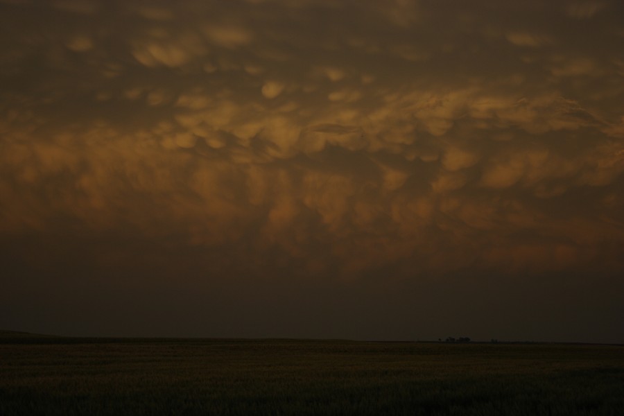
CoD was on the storm in Hall County TX

Lot of precip but I have to question the LSR that came out for the storm we were on about a rain wrapped tornado. A slightly rotating wall cloud with rain shafts..yes...tornado? Uhh..no. We were in perfect position for nearly 40 minutes on that storm.

The storm was VERY impressive on radar but just couldn't get it's act together.

Wish I knew who the chasers were that called it in. I'd like to see the pictures to see what we missed.

http://www.allisonhouse.com/chasing/2006/CoD/day6/

IMG_0018.JPG

IMG_0017.JPG

-Tyler
 
[attachmentid=240][attachmentid=241]Started off in Amarillo, TX and drove northeast to Pampa. On my way up highway 60, the first Svr. thunderstorm warning was issued for Gray County. It seems to be ironic, but as soon as the warning was issued, I saw this feature about 1 mile south of highway 60 and south of Pampa. It is high base, but it was really getting its act together. It lasted about 1 minute and quickly dissipated. After leaving Pampa, a supercell was forming and gaining strength in Beaver, County. Hit highway 70 and headed north. I got to the storm, and by this time, cold air and outflow was disrupting its inflow. Lots and lots of scud in this storm. Picture on top is the pampa funnel and the bottom is the Beaver county storm.
 
I was also on the Hall County Tx storm. Like Tyler said the storm looked very good on radar, but never got too much going. This storm did have some really nice lowerings at times, esp. East and Southeast of Turkey. I too was in perfect position and never saw a rain wrapped tornado..........not saying there wasnt one, but I was in very good position and never observed one. I am sure I saw you guys Tyler as there was only about 4 or 5 chasers on this storm........myself included. The storm turned into a mess once convection from the south ran into it. Overall a good day........even though no tornadoes observed. Will try and put pics up when I stop for the night.........I am currently in Vernon, Tx and will probably stop around Altus or Lawton for the night.
 
Had a close encounter with a weak but photogenic landspout SW of Matador. Got a late start, and hooked'em east on 62/82 out of LBB under the shadows of high-based convection behind the dryline. Was intially a little disappointed by the heavy traffic in the sky but remained optimistic, blazed up 70 out of Dickens and intercepted a dusty landspout in rural Motley County. This post is useless without images, currently back home tinkering with my new camera. KAMC now airing landspout footage. Missed the action in Turkey, Tx, stopped at Allsups on the way home and heard a deputy and local talking about some damage reports in that area, not sure if it was related or not.
 
Started off the day near Groom and found a wifi hotspot and sat and waited. Saw some great storms developing to the south, west and north. Wound up going east out of Groom to Hwy. 70 and headed south towards Clarendon. As I got about 3 or 4 miles north of Clarendon I started getting sporadic hail ranging from nickels to ping pongs. As I got a bit closer to town, the hail got a bit bigger with an occasional golfball. Heard reports of baseball hail to the west of Clarendon. As I got directly on the west side of town from Hwy. 70, I saw hail on the ground ranging from nickels to tennis ball size. Thank God the hail had already fallen when I reached the location. Hit 287 east of Childress and went south on ranch road 1033 and tried to catch the storm south of Childress. CG's were popping everywhere as this was the storm that "supposedly had the rain wrapped tornado". As I neared closer the storm fizzled out due to a storm to the south. Pretty much gave up south of Paducah and came back home to gear up for the 3rd.

I got a chance to talk to Mike Mezeul today in Paducah. It is always a thrill to meet and talk to the poeple in this forum. He told me that he got a tornado near Turkey so I just wanted to congratulate him and say that it was nice to finally get to meet/talk to him. Here are a few pics of today's chase.


storm developing south of Groom
dsc046804fm.jpg


base of storm looking SW from Groom
dsc046813vk.jpg


hail on the NW side of Clarendon
dsc046940et.jpg


dsc046950uu.jpg
 
Well Kanani and I got a very late start leaving amarillo due to her job but we finally left a little after 4pm. We headed SE on 287 towards the childress area. The storm to our SE near Turkey was showing good rotation and looked to be the best of the bunch. BY the time we got to Memphis it was already tornado warned. WE continued down 287 in hopes of getting in front of it but by the time it was south of childress it had weakened and lost its shear. The storm NE of Childress ahead of the line took over then. WE went to Quanah and up hwy6 for a bit before the core cut us off so we back tracked and went further down 287. WE could see a very well defined wall cloud with strong rotation in it to our north. Kanani (in her masterful navigating as usual) found us a small FM road that went north then east out of Chillicothe so we took it trying to get just ahead of the rotation. As we came up on our east turn about 2-3 miles north of Chillicothe we saw very strong rotation just to our NE. Within seconds a nice multi-vortex cone dropped a few hundred yards to our east. We were in moderate precip and heavy winds and looking east so our contrast was terrible but we were able to grab a few pics and about 20 seconds of video before it totally wrapped in the rain. We then were overtaken by the core and had to drive east out of it as best we could. We never regained visibility on the tornado. We tried calling OUN but couldnt get through so I called Amarillo's NWS where they know me and had them pass the information on. A few minutes later we came up on an intersection and ran into 2 other chasers in a white Taurus with a broken back drivers window. We stopped to ask if they had seen the tornado also which they confirmed they had. I guess us 4 were the only ones to witness it. I dont know who they were but I hope I find out. After that we worked our way south and east into Vernon and mostly gave up the chase there as the storms were weakening and it was getting late.

All in all a great chase for us. I had to adjust the contrast on the picture a bit but it clearly shows our cone. I will send a copy of it to OUN so they can confirm it.

May2ndtor2.jpg
 
Caught up witht eh cell West of Childress and followed cells towards Vernon Texas. Sat in 80+ mph winds in Chilicothee and took pics and video of the rotation that prompted the Wilbarger and Hardeman county tornado warnings.
Also headed south of towards Lake Kickapoo Texas after dark and saw a great structured storm and took some lightning shots.
Ill post more later. Gonna try to get some sleep and storms are forecst near here tomorrow as well.
Thanks to Jeff Papak and others for nowcasting today for me and Robert Sternadel.
 
Aaron Ruppert, Khoi Le, and I witnessed a violent rainwrapped tornado between Quannah and Vernon, Texas, just north of Chillicothe (sp?). We missed the Turkey tornado, which was reported to be wrapped as well, but saw an amazing wall cloud and rotation before that cell merged with the storms to its south. Luck played in our favor today as storms fired ahead of the primary convection and managed to tap some warm inflow, and we happened to be in the right place at the right time. It was raining continuously during the wall cloud formation, and tornado, even though we couldn't have been more than 1/2 mile away. It lasted approximately 30 seconds and churned up the farm dirt quite intensely. Gotta love May folks!

5-2-2006-chilichote.mpg

Video Stills

This view is looking to our WSW
 
few minutes later we came up on an intersection and ran into 2 other chasers in a white Taurus with a broken back drivers window. We stopped to ask if they had seen the tornado also which they confirmed they had. I guess us 4 were the only ones to witness it. I dont know who they were but I hope I find out.
[/b]

That would be Chad Lawson & Mickey Ptak, two of my regular chase partners. Unfortunately, I wasn't with them today <_<
 
Thanks for the info Shane. We all just timed it perfect. 30 seconds sooner or later to that spot and we would have missed it.

I guess Adam also caught it obviously except they were east of it and we were on the west side deep in the hook. Congrats guys.

I just sent a report and a pic to OUN. I notice they dont even have it listed on the LSR so SPC doesnt have it either.
 
i will post a full chase report tomorrow, if im not chasing :rolleyes: 
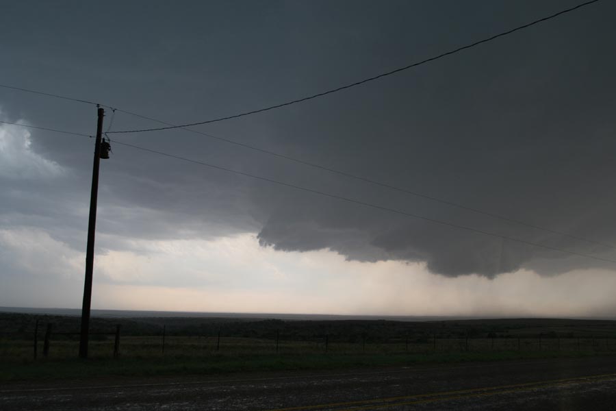
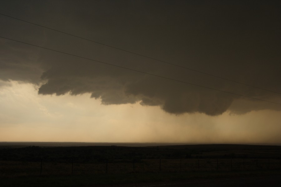
brief summary for the day, left dfw at 11am, got to childress around 3. intercepted the tornado warned cell to the sw of childress, not much to look at first, stuck with it for a while and eventually intercepted the turkey tornado, which quickly (after about 30 seconds) became rain wrapped. i did manage to get some nice video of it though with what looks like trees or something being tossed in the air. anyways, after that, the storm became quite the hp storm so trotted back east and eventually south towards paducah to check out that storm....got a free car wash thats about all lol. also ran into jason boggs and chatted with him a bit and swapped stories, its was great to meet jason finally, and i have to give him props on his truck...lol... anyways here are some pics and like i said ill have a full chase log up soon. congrats to everyone today and good luck tom!

so yeah...found out where this guy has been the past few years...WEST TEXAS!! duhh who woulda thunk
42606019.jpg


nice cg
42606021.jpg


nice wall cloud over turkey
42606030.jpg


descent tornado before getting rain wrapped
42606039.jpg


wide angle shot
42606040.jpg
 
Hi,

Well done on those eastern storms.

We initially headed to Shamrock and then immediately headed south to Memphis and straight to this storm. Any comments would be appreciated as this was very close to producing but I found some interesting precioitation motion just after this - all on video. Rotation was reasonably strong at this point.

0502ds01.jpg
this photo is courtesy Daniel Shaw.

0502jd03.jpg


0502jd04.jpg


0502jd08.jpg


Nice surprise - great structure overhead with the wall cloud - let alone the hailstones we had to pass through to get to it. No roads beyond this point. We headed east but that meant the circulation would eventually become rainwrapped.

We eventually got onto a dead end road and two vehicles got stuck - end of chase.

Regards,

Jimmy Deguara
 
We started out on the Kent County, TX storm where we had lighting strick a tree just across the road from us and ended up busting a windshield with golf ball hail.

Left that storm and joined the one along I20. Saw no tornadoes but a really good funnel that wrapped up fast, we lost site of it, don't know if it touched down or not.

By far though the biggest prize for us today was the most awesome display of mammatus at sunset that I have seen in probably 8-10 years!

050206mammatus.jpg
 
Tommy and I did not chase yesterday due to finals studying, we did however catch a really cool shelf cloud along HWY 62 near Newcastle OK between ~915-930PM. Sky was considerably darker, but lightning greatly helped to illuminate the area making photos possible.

1s.jpg


2s.jpg


3s.jpg


4s.jpg
 
Went out yesterday with Robin Tanamachi and two other grad students, Haixia Liu (another student in my research group), and her husband, both of whom had never been chasing before, so it was great fun to take them out and introduce them to the world of chasing! We headed out of Norman around 2:00 p.m. or so toward an intial target of Childress. We stopped in Altus after hearing about initiation, and decided to keep driving west to get a look at the base of the Donley County storm, which was showing some nice rotation at the time. Upon reaching the intersection of 62 and 83 in Texas, we quickly realized that the outflow from the Hall County storm was eating the Donley county storm for lunch, and furthermore, a new cell was going up to our south, which became the Hardeman/Wilbarger County HP. We opted to blast back east on 62, and then headed south on 34 to 6 toward El Dorado to try to get ahead of the storm. We drove through some very heavy rain in the core of the storm, with a few small hailstones. It was a little tense for a moment, but thanks to some awesome nowcasting support from Jeff Snyder, who was able to keep us updated on the location of the circulation (which was very close to us as we crossed the Red River, although only in the midlevels), we decided to punch ahead into Quanah and take 287 ESE to parallel the storm. We had to stop for gas in Quanah, so we got a little behind the storm, which was quickly beginning to bow out and accelerate. We saw a brief wall cloud in the rain free base as the storm passed north of Vernon, and then the whole storm gusted out. Since light was failing, we called the chase off, headed east to 44, and enjoyed the lightning show on the way back home.
 
Back
Top