5/14/06 REPORTS: NC

Bill Hark

EF5
Joined
Jan 13, 2004
Messages
1,348
Location
Richmond Virginia
Storm Chase May 14, 2006 or The Pain and Agony

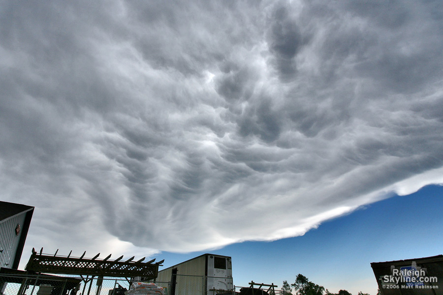
With an approaching 500 mb speed max, cold air aloft and a predicted weak surface low just south of the NC/VA border, and backed winds from southeastern Virginia through north central and eastern NC, I was expecting a possible chase day. After checking data, my target was the Roanoke Rapids to Rocky Mount area along I-95. The best upper level winds would be just south of the border. I left at approximately 2:30 and headed south along I-95. There was already a severe thunderstorm watch for southern Virginia and North Carolina. I was surprised that a tornado watch was not initially issued considering the parameters. Just south of Richmond, there was nice clearing after earlier convection.
As I passed Petersburg, Virginia, I noticed some convection already firing near Raleigh. There were already some tornado warnings west of Raleigh but I was interested in the leading edge of storms including a west to east line of storms just northeast of Rocky Mount. It was moving northeast to east. One storm south of Henderson was having persistent rotation according to XM. I chose this healthier storm and in Roanoke Rapids, I turned west on 158. When I reached Littleton, I turned south on 4. A tornado warning was issued for "my storm" including the towns of Centerville which was about 16 miles to my southwest. The storm soon fell apart and I saw nothing but a few lightning bolts and a lot of rain. I turned east on 561 and stopped at exit 160 on I-95 to check more data. The storms had become a mushy line. There were additional storms forming well to my east including one near Edenton by the Albemarle sound. It had great rotation, previously producing a tornado (Congrats to Bill Coyle who was on it and saw a nice wall cloud.) The storm was too far to my east and would soon be over water. With all the storms coalescing in to large mushy mass, I decided to bag the chase and I headed home. I left at approximately 5:30.

The Pain and Agony:

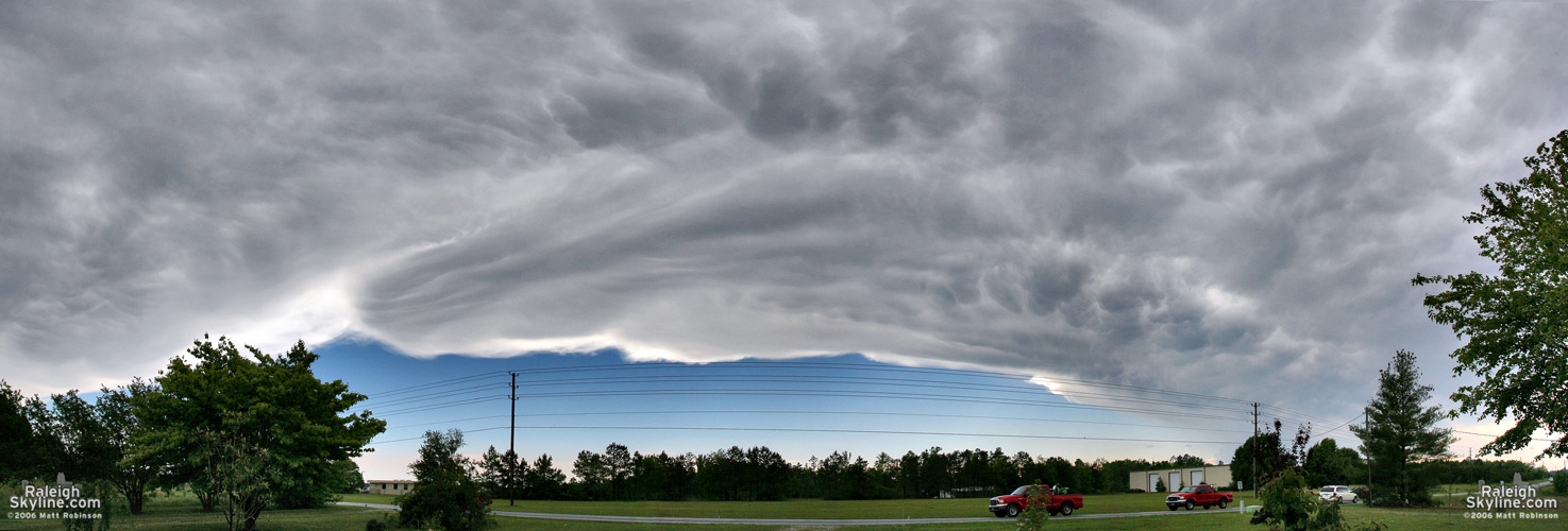
I continued to watch XM for a while and there was nothing interesting except for those storms near Edenton. When I arrived home at about 7:15PM, I checked my computer. TORNADO WARNING!! I was staring at a storm crossing I-95 about 15 miles south of my position when I decided to head home. It was isolated and had a nice couplet. Arrgggg I guess the additional storms formed as the higher level winds rotated into the area. I had assumed the atmosphere would be too worked over after the previous storms. Oh well. I now face a two and a half week chase vacation of Omega block.

Bill Hark
http://www.harkphoto.com
 
Myself, Mike Strickler (NWS Raleigh), Paul Suffern, Zach Brown, and Morgan Silverman chased today in Central and Eastern NC. We started out the day driving S out of RAH on the TOR warned supercell that produced a tornado 7 NE of Concord (near Charlotte). The supercell had been around for quite sometime and was rather isolated, as at the same time, convection was blowing up on the nose of the jet over Central NC. Beautiful mammatus and anvil, and as we intercepted in Sanford, the edge of the updraft went to mush and the storm shortly thereafter.

<div align="center">
st1.jpg


Anvil and mammatus on US 1 coming S into Sanford.

st2.jpg


A isolated supercell in NC? Can't stick around for long!</div>

After the cell started trending downward, we raced back to the RAH metro to intercept newly developing storms in Orange and Durham County. Once we rounded the beltline back toward Durham, we were able to get a glimpse of the TOR warned cell over N Durham from the I-540/US 70 JCT. Very nice mid-level striations, rising scud, and a menancing looking wall cloud.

<div align="center">
st3.jpg


Looking NW from the I-540/US-70 JCT between RAH and DUR.

st4.jpg

st7.jpg


At the I-540/US 1 JCT a bit later.</div>

Flanking line had plenty of scud on it and when we first drove up, there was a hint of an RFD. We then proceeded E along 540 to just W of Rolesville, where the circulation passed just to our E. We had a very nice RFD kick and quite strong cloud base rotation. There were some scud tags at the base, but no visible funnel. The public reported a tornado shortly thereafter in Rolesville, and unless it was completely obscured by (1) rain or (2) trees, I'm not sure how we missed it considering were were "right there". Mostly likely, the tornado developed on the RFD occlusion we witnessed, but just over the trees or in the rain. I did see a photograph of some structural damage in Rolesville on WRAL-TV's website. I guess we'll wait to see a damage survey.

<div align="center">
st5.jpg


st6.jpg


Just W of Rolesville, looking NE/ENE.</div>

Afterwards, we continued E on US-64 toward Spring Hope. It was about this point the storm decided (at least from what my base told me) to move a bit south of east. The hail core crossed US-64 just W of Spring Hope. Zach, Paul, and Morgan in Car 1 ended up with some golfballs on the west side of town. Myself and Mike, in Car 2, lost contact with the other group when we started receiving some hail, and continued going E.

We continued on US 64 through Rocky Mount and headed toward Robersonville and Bethel. While on 64 heading into Bethel, we picked up a significant wind shift twice (uh oh) which was visible in the rain curtains. We were told the circulation was just N of 64, and I think we kinda went right through it. There was again a public report of a tornado near Robersonville, but we saw no damage and experenced winds no stronger than 30mph. Now after dark, we raced E to Williamston and again the S side of the circulation crossed us. We had taken shelter underneath the a gas station overhang and got at most dime size hail. We continued on 64 toward Plymouth and once again ran into pea to dime size hail before stopping for the evening.

My friend and fellow meteorologist Christian Cassell, who lives in Sanford, NC in Lee County, observed a tornado from the deck of an apartment complex on cells that developed a few hours after we left to go back and chase storms developing near Raleigh. There was apparently some damage in Sanford and Broadway, but no reports of injuries. Congrats to Christian as it's his first tornado! :) Geez, thats the luck of chasing huh? Drive hundreds of miles but you could just step out on your deck...;)

All in all, a great day of chasing in Central NC. Considering this is the 2nd chase day we've gotten out of our big E coast trof, I shouldn't complain too much! :) Can't wait to get out to the Midwest in a few weeks for the real show.

BIG THANKS (as always) to Shane Young (Florida State) for basing us throughout the afternoon and evening. Couldn't have asked for more..he was terrific. I thought I'd choke and die without GRLevel3 today on the road (my laptop's motherboard fried on us a few days ago chasing).

Photos courtesy of Paul Suffern!
 
Yesterday was one of the better chases I've had in NC in years - no tornadoes or even funnels seen, but plenty of good supercell structure. I left Goldsboro around 2:30pm, initial target was the Greensboro, NC area. Took 70W to Smithfield, when a cell in northern Wake county began to grow on radar and showed weak shear on the WxWorx. Got on 96N with plans to intercept 30-40 more miles north, but after only a few minutes going up 96, noticed that a second cell farther southwest in Harnett county was also growing in size. This storm was heading more or less right for me, and an intercept would not take long, so I went after it. Took Hwy 42W to and through Clayton, NC, continuing west to the Hwy42/I-40 intersection. Did not see very much structure with this storm during the time I intercepted, only a relatively high base with boiling scud beneath and lots of rain and lightning. Planning to meet the storm again later, I took I-40 north to Raleigh and then US64 east towards Rocky Mount. Never got more than 3-4 miles south of the updraft base of the original cell, but before reaching Rocky Mount a new cell had developed to the SSE of the first. By the time I reached I-95, the new cell had strengthened and was now just NW of me. I attemped to stay up with the base as long as I could, which ended up being about 30 minutes - eventually waved goodbye to that storm as the road I was on came to a dead end, somewhere northeast of Scotland Neck, NC. I backtracked the 20 miles back to Rocky Mount, reaching I-95 around 6pm or a bit after. At this time a new storm in northen Wake county was rapidly strengthening as it moved ESE. I headed back down US64, this time going west, to meet it. Around 6:45 pm I got first view of the base of this storm up Hwy 98 near Bunn, NC - and it looked to be a beast, it had the best structure of any cell I saw yesterday. A low, black updraft base and wall cloud with a backdrop of deep aqua signifying severe hail in the core. I maneuvered south and east around the hilly back roads north of US64 before the storm's updraft reached 64. At that point the road options were limited south of US64, so I decided to gamble and try and beat the area of rotation to the next exit east, about 5 miles down the road, with my plan being to book south on the next exit out of harm's way but still be in a good spot to see. The plan failed, and I was forced to slow down and then pull over on US64 about 2 miles before the exit as the rotation crossed the highway. I waited here 3-4 minutes wanting to give ample time for anything rotating to get east and out of the way before continuing east. I tried to catch the storm again as it crossed I-95 and moved into Rocky Mount but realized quickly that was not going to happen, so I booked south on I-95 towards more convection firing in Johnston County. Chased those cells for the first hour after dark and then headed home as everything began to line out with the advancing cold front. I did not take any photos but did take some video of the wall cloud from the first Rocky Mount storm and of of the base of the Bunn, NC storm later in the day. Will attempt to get some clips online tonight if i can figure out why my website and IIS is being flaky.
 
Not much to report, but here is the same anvil cloud Chad saw with embedded mammatus from yesterday around 4:15 PM from a dying storm making its way just south of Raleigh:

05.14.06.anvil_mammatus_raleigh2.jpg


05.14.06.anvil_mammatus_raleigh3.jpg


Panorama of it:

05.14.06.anvil_mammatus_raleigh.jpg


I started to go after it but it quickly vanished once it got into Harnett Co.
 
Well as always I am late with a chase report and I suck at them so here I go.

I knew about the risk of severe weather on this day but I was called by Bill Hark who let me know that the setup looked better then I was think at the time. I started out at home in Virginia Beach Virginia and headed south on Rt 17 to get in front of the storms that had already fired off near Raleigh NC. With no data and no Threat Net I was riding blind until I called Dan Robinson. I made a stop along Rt158 and Rt17 which would leave me with a west,east,north,south option. I called Dan and he said I was in a good spot. I finished with Dan on the phone and something told me to keep going south so I made my way to Edenton NC right along Rt32 which is a bridge that crosses the Alberarie Sound. I waited on the north side of the bridge as the storm was moving in on me from the west (Clip 1) . Then I got a call from Dan telling me that there is a tornado warning for my cell and the Threat Net was showing a 103 shear marker just over the other side of the bridge so I had to punch the core on the bridge( Clip 2). As I made my way to the other side of the bridge the rain turned to hail and everything was white I knew I was getting close to where I needed to be. I made my way to Rt64 I turned east and the hail and rain stopped on a dime. Then I saw the wall cloud to the west with good lowering( Clip 3,4,5). At one point after looking at the video there was a lowering to the ground and I was thinking it was just scud but it was moving sideways not up or down....who knows..I made my way along Rt64 where the wall cloud redeveloped and had good motion but later it fell apart as did the storms( Clip 6,7). A big thanks to Bill Hark for getting me off my lazy A#$. And a very BIG THANKS to Dan Robinson for putting me under wall clouds not once but two times in the last year or so.

Here is the video: http://www.valightning.com/clips/ncwallcloudweb.wmv

meso-2.jpg


meso-3.jpg


meso1.jpg
 
Great Plains Storm Chase 2006 for me, Dave Carroll, Seth Price and 9 college and high school students began on Sunday by ... chasing NORTH CAROLINA. We made an early decision Sunday to forego travel west to uncertain/improbable severe weather odds to chase what was immediately available on Day 1 in NC/Va. We ended up intercepting several cells between 1 and 7 p.m. in the afternoon, encountering some hail, observing some lowerings and rotation ... and filming the approach of a spectacular tornado-warned supercell over metro Raleigh-Durham that eventually produced a funnel cloud for us.

durhamfunnelb.jpg


I apologize for the small size of this photo, it's the only thing I can do for now, but this is a video still shot by North Carolina-Asheville meteorology student Jacob Carley of a funnel cloud near the Durham-Granville county line in central North Carolina. (Tiny funnel to the upper left) ... There appears to possibly be a debris whirl under it at ground level ... it convinced National Weather Service-Raleigh enough to add it to storm reports as a tornado. I'll try to get a bigger or more tightly zoomed version up eventually.

We're now near Nashville now headed west trying to figure out where it is we're supposed to go with this blocked pattern.

More on my weather blog on Roanoke.com.

Click here for bigger version of photo above.
 
Back
Top