4/28/06 REPORTS: OK/TX

Shane Adams

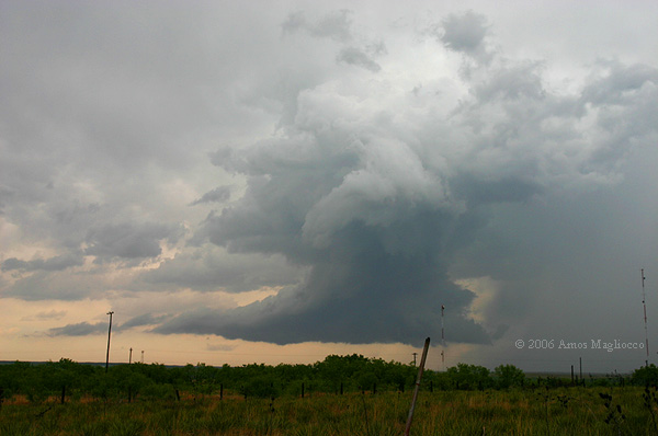
I observed a tornado west of Granite, OK this evening between 5:58-5:59pm CDT. I targeted the US62 corridor between Altus and Hollis, and was south of Eldorado as the storm first developed. Sat and watched it trying to decide whether to drive south to Quanah then go northwest on US287, or drive back north to US62, then blast west to Hollis. I finally opted for the latter, and intercepted the storm along OK30 north of Hollis. I made my way to OK9, then drove out ahead of it by a few miles. I would do this, stop and shoot video for a minute or two, then move east again. I basically "got chased" like this for the better part of an hour, jogging north briefly on US283 then catching OK9 again east to Granite. I stopped about five miles west of Granite and noted an area that seemed to be developing rotation. The scanner reports by Scharf and the gang were very accurate and detailed, and told me the storm was basically a cold crap hailer. Having this mindset, I was even skeptical of my own eyes as I watched rotation develop. It became rather rapid, as the OUN coordinator came across the scanner asking if anyone had a visual on the storm's updraft. I replied jokingly "yes" to myself as I continued to watch the rotation strengthen. It seemed to cycle down and rain began to intrude, so I bailed east a few miles, then pulled over again. Once again, the rotation was fierce, and before I knew what was happening, a cone tornado developed fully condensed to the ground. Seconds later a vigorous debris cloud spun up beneath it, lasting only seconds. The tornado continued, and then rapidly roped out. It may have lasted a minute. After it dissipated, a new area of rotation began immediately southeast of where the tornado had been, but this one quickly filled with rain and the show was basically over. I traversed the Quartz "Mountains" in an attempt to stay with the storm, but by then it was crap. Drove to US183, then headed south to US62 in Snyder, where I set up just south of the bridge to wait for the next round coming up from the Childress area. I got bored after ten minutes and decided to call it a day. Another satisfying backyard solo chase. Complete summary will be done over the weekend. I'll post when it's up.

Chris Lee of KOCO-5 was across the road from me so this tornado will be on channel 5 in OKC.
 
Sat on my back deck in Argyle, TX and watched that warned cell move over the speedway and just a couple miles north of my home. Had the entire thing on video- got multiple power flashes (couldn't see a funnel or anything), but something had to have been on the ground with the path of flashes I saw and how many. I went to check my video out and I realized I pulled the biggest mistake.... I didn't take my lens cap off of the video camera. My wife was watching the entire thing with me and we were both excited to see what I got on the video and how the power flashes turned out. Got a lot of great audio though :(
Life goes on I guess. Not a bad night though for just sitting on my deck looking west though, so I can't complain to much.
 
I went out with Robin, Dan, and JR, targeting an area near and south of CDS. We arrived in CDS and hoped that the convection that fired around 1pm west of ABI and south of Quanah wouldn't become a problem. By mid-late afternoon, new convection was developing along the cold front - dryline intersection to the west of CDS. We followed this intersection southward for a bit, but it was becoming quite obvious that the cold front was undercutting the convection. It's never a good thing when you have a southward moving cold front with storms that are moving NE slowly... So would develop sw of CDS, but then quickly get undercut... We did see several dust devil / gustnado vortices right along this cold front, which was kind of neat. Between CDS and Matador, we decided to head back north to see if we could catch up with the cell that was entering Harmon Co OK. We moved through Hollis, and stopped in Duke after seeing that this sw OK storm was weakening. New storms had developed back to the SW near Matador, but we were fearing that they would see the same fate as a handful of other hopefulls saw earlier in the day... We made it to Quanah, but the cells were lining out, so we opted to call it a day.

I think there were several failure modes with the convection in the northern part of the risk area... First off, the convection that fired around noon in western north TX moved eastward only very slowly, so that by mid-afternoon, there was only a 2 county wide area between the dryline and the cool outflow from those storms. In addition, this cooler air was advected towards the CDS area on the southeasterly sfc flow. Secondly, the cold front continued to move southward faster than I was anticipating, so the half dozen or more storms that did try to develop at the cold front / dryline intersection were quickly undercut and left in cooler, more stable air. Third, the storms seemed to initiate in a SW-NE fashion. We a northeasterly shear vector and southwesterly flow aloft, there was a tendency for upscale growth to line segments (anvil seeding, etc). Related to these previous two points is the flow in the mid-levels, with a slight backing vertical wind profile in the ~700mb area per local VWPs and RUC analyses immediately ahead of the dryline.

I can say that the hodograph on the 0z FWD sounding is one of the most impressive I have seen in a long time. >500 0-1km SRH and 75kt 0-6km shear? That 0-3km layer on the hodograph is incredible! The low-level hodograph on the DRT and OUN soundings are nearly as impressive... Man, I would have liked to have seen what would have happened if we had more significant destabilization today given the shear that was in place...
 
Hi,

I will make it rather brief here. No tornadoes but a nice dust devil raced across the road in one case. After a failed attempt to head northeast to favourable looking storms up NE of Snyder, we opted to head back to Sweetwater. Just south of Sweetwater, a nice looking cell emerged - if only there were less interruptions from others south.
 
Started off the day in Tulia and did a round trip of 453 miles to see a few lightning strikes, some flooding and some hail. The storms today just seemed to get undercut by the cold air from the front. I could only seem to get in the inflow for a few minutes today and then get slammed by cold north winds. Boy, what a dud day to say the least. Here are a few pics for ya. I'm going to bed.


photos of storm near Guthrie, TX looking to the west
dsc046752pq.jpg


dsc046788ab.jpg


video stills of hail up to 4 inches deep 6 miles south of Wellington, TX
dsc000019ua.jpg


dsc000028sl.jpg
 
I headed out early from Wichita Falls towards the cells which fired SW of Guthrie Texas and was a little disapointed that cells were forming so early. I would have liked for more sun and destabilization to occur and cells were forming not too far West of the main body of more elevated warm air advection convection.
I caught the cell near Guthrie and followed it towards North of Benjamin and observed a very disorganized wall cloud as well as some decent inflow structures into the cell.
This cell would become more outflowish and liear so I headed back towards new cells that were forming and backbuilding towards Haskell. I sat in Rochester and watched a decent rain shaft head towards town but nothing too exciting. I kept noticing while there were lots of towers going up all day. None of them ever got that good rock hard look to them and usually looked almost half mushy.
I did get a nice jump when lightning hit about 100 yards in front of the vehicle while sitting in Rochester. Still a bit unsettling with the antennas on my vehicle and my cloase call with lightning from last chase season.
I finally would let this cell go north and went west to get into more sunshine and watched as new cells formed towards the SW and also NW towards the Childress area cell which had moved out of the panhandle.
I was tempted to blast North on the cell heading into Harmon county and might have caught it but I decided to finally settle on the cell SW of Childress and watch the storms backbuild into a line. I took time lapse of the cell to the SW that moved towards Haskell and also took timelapse of the Towers going up due west of me as the sun went behind them. This did lead to a beautiful scene with a striated gustfront and towers above them and scud being formed underneat the gustfront. I took some very nice stills and this and will have a nice stitched photo of the whole W to N horizon with "Jesus rays" coming from the sun behind the towers. From atop the hills North of Guthrie it seems like you can see to Childress.
I am eager to see the tornado from SW OK as on radar it didnt really seem to impressive. Of course from what i hear it was a very very brief tornado as well. I am not even sure if a tornado warning was issued on the cell?
There was also a report of a brief tornado touchdown on the cell I took time lapse of to my South Southeast. It was a sherriff report so we all know how those can go. I heard it was a funnel cloud at first but later heard that it had indeed touchdown briefly. I am also unsure if a tornado warning was issued on that cell. I did see where a tornado wanring was issued for Palo Pinto county and from what I could tell the main circulation passed very near Possum Kingdom Lake. I have a cabin down there so if anyone knows of any more details on that cell id appreciate it.
This was a bit of a low end moderate risk but it was a moderate risk. I think it bombed for moderate risk status especially on the North end but I always say its better safe than sorry. Of course Im not totally sure if a moderate risk was totally warranted for 4/24/06 either as there were only 3 or 4 tornadoes nd msot of those were with the El Reno cell.
It was a satisfying chase today I suppose but even just nice structure storms please me. I think tho with the gas prices we would all like to get a little more lucky on or chases this season. It is about to be May so hopefully mother nature will throw us all a few bones.
Ill work on pics and even some video tomorrow while wathcing the NFL daraft :p. So much for Reggie Bush going to the Texans. Vince Young isnt going there either. Lets hope Mario Williams is a tornado in the NFL for the Texans. :p

http://www.texhomastormchasers.com
 
Didnt really get to chase much since y partner was working and I had duty but I did get out and "spot" the Happy, Tx supercell since it was right on the border of my county. I headed south on I-27 as the storm was just entering Swisher County. By the time I got to happy is was about 15-20 SE of Happy moving NE at 30. I set up about 5 miles south of Happy. WxWox was showing a nice core and had an 80kts shear marker. I could make out a nice base with good roation. About that time the cold front came sweeping south and undercut the updraft killing any chance for a tornado. the storm then became a prolific hailmaker. I headed north back to Happy when I ran into a hail core right as I reached the the south side of Happy. It was nickel and a few quarters but mostly pea's and marbles but it was so intense I couldnt see more than about 10ft. The hail started to cover the road a few inches deep. it loked like a snowstorm in January. Most cars were stopped on I-27 with a few in the ditch. I was able to get to my east option and busted east but this meant I would stay in the core for a bit longer. As I headed east towards Wayside I encountered more quarters and a few golfballs before I busted out into clear air. The storm had gotten ahead of the front again and was again showing good rotation and a nice base. Then the front caught up again. I played hopscotch with this storm as best I could until it got to Clarendon where I broke off as it seemed to just continue to ride the front and get undercut every time it got its act together. I reports 1.25" hail to the NWS but dont see it listed. I am pretty sure I had some golfballs in there too as it cracked my windshield and took a chunk out of my bug deflector but biggest report I saw was 1" from Wayside. I will have to call the AMA office to find out what happened to my report. I havent had time to look at my video but if it turned out ok I will try and post a video grab or 2 of the hail.

Looking at radar I think this was one of the better storms of yesterday and was totally isolated. I think the only reason it didnt drop a tornado is the cold front kept undercutting it. Looking at the track it appears Jason Boggs caught the same storm later in the east panhandle and got some shots of the hail covering the ground like I encounterd. Guess this thing never stopped dropping hail.

Wish I could have chased the storm into Oklahoma where apparently it dropped a tornado near Mangum but like I said my partner was working and I had AES duty and had to get back to Amarillo. Oh well vacation is only 19 days away.
 
SHORT SUMM: Sampled storms at Aspermont, Sweetwater and Fredricksburg. No T's.

LONG SUMM: Headed west on I-20 toward target of Sweetwater. Diverted northward to Aspermont to intercept initial cell out of Snyder. This high-based hailer had a nice flanking line but was moving into less stable air, so we dropped back to I-20 and headed to Sweetwater. South of town, we intercepted a supercell and ragged wall cloud, but it soon was undercut by outflow from prior storms. No other storms looked good except for the pair of supercells north of Del Rio. It was 4:30 PM and Carson wanted to bolt south -for three hours. We arrived on the tail-end charlie storm about 7:30 PM when the storm reached I-10/290 west of Fredricksburg. This HP supercell had incredible structure: a barber pole updraft, towering cumulus inflow band to the east, a mid-level flat band of clouds, and a knifing anvil that cut the blue sky in half. However, only minor rotation was noted in the wall cloud. We followed the storm to north of Fredricksburg where darkness came quickly. We ate dinner at a German Bierhaus in town then escaped east on Rt. 290 when another tornado warned supercell approached about 9:30 PM. Got to Austin then headed north on I-35 for a rainy drive home. In Fort Worth, we came upon a serious three-car collision that blocked the Interstate. We pulled over to the side of the road. Meanwhile, two small trucks and an 18-wheeler didn't see the roadblock and roared past us at 70+ MPH only to slam on their brakes just missing the wrecks. Three scary moments there. TOTAL 815 MILES 16 HOURS.
 
We tried to beat the western Oklahoma storm to the intersection of 9 and 30 in Vinson, approaching from the south on 30. We almost made it, but thank goodness we didn't push on through the hail because there was a later report of baseballs taking out windshields just to our northeast. The hail was dry, hard and wind-driven so we got dents and a small crack in a side-view mirror despite the biggest stones only being about 1". Of course, that put us out of position for being there later, but we had blown it off anyway because it seemed to be a cold, outflow-dominant hailer.

My push-pin was in Greer county yesterday morning...drat! But it's just one of those things...I'm pretty happy with my forecast. Congrats to Shane and all the others who caught it!
 
2006april28%20004_JFRadjustMID.jpg

Wall cloud near Sweetwater, Texas April 28, 2006


I chased with Scott Eubanks and we saw a few semi-interesting storms, the first near Snyder and the second at Sweetwater. The Snyder storm exhibited a large wall cloud but I never discerned serious rotation. The later storm also had lowerings in the vicinity of various mesos, but never threatened. When the first sensible RFD from our Snyder storm reminded me of the walk-in freezer from my high school Dairy Queen job, I wondered if we might be in trouble.

Scott and I took a wild ride through northeastern Scurry County to find the secret passage northeast of Snyder across the creek in the northern part of the county. Street Atlas was dead wrong about not one but two rural roads and we lost our storm because of a missing road (who took the road?) and a bridge that didn't exist (Bring Your Own Boat?). We rolled through canyons, over dried creek beds, into open rangeland with loose, befuddled cows, and onto what looked like an access road astride someone's field of winter wheat. We might as well have beein chasing the Ozarks. Meanwhile our storm was spinning like a top, with MTM displaying higher shear values than ever. This is when a sheriff reported the brief funnel in Stonewall County near Peacock.

"Bob's Roads" are always a gamble but we assumed today's storms would have a limited period before they lined out or joined larger convective clusters and we wanted to stay as close as possible for as long as we could. Plus the map indicated there was a way to do it.

Our assumptions about today's mode and evolution were wrong. Despite the removal of CIN (per SPC objective analysis and hinted by MAF 12z sounding), when the lift arrived, the convection was not immediately widespread and messy. Our first storm was a discrete cell for nearly two hours and the second one for about half that time, before a line filled in and the squall was on.

I had an early dinner with a friend and decided to return to Denton where I met the night's weirdest tornadic supercell. This storm raised reports of power flashes near Alliance Airport and lowerings galore (none of which was easy to confirm due to the lack of lightning). They blew the sirens in town and that was probably the right thing to do given the power flash reports. I found myself under a wall cloud or a relatively compact updraft base after I couldn't find the intersection of 156 and 114 to flee east from the approaching meso. As far as I know, nothing touched down in Denton County.
 
Summary: David Douglas and I chased a splendid couple of supercells on the southern end in southwestern Tx Hill Country in beautiful scenery with large hills, winding roads, creeks / rivers. These storms were intense and seemed to have some type of symbiotic relationship. Southernmost cell with my highest known 80dbz core. Northern storm had a long flanking rain free base area with multiple lowered wallclouds and possible large torn obscured by hill in foreground. With southern cell we experienced loud low frequency hail roar, bright hail shaft, ground hugging wallclouds, at least one funnel cloud, and possible large block tornado northeast of Fredricksburg on ground nearby after dark. I'll try and provide pics a bit later but busy with weekend stuff right now. I did got some good shots of supercell wallcloud features almost on ground with beautiful hill country landscape in foreground. David shot some mammatus.

Account: My target from the day before was approximately Junction. Left Cedar Park about 4pm. Headed west on hwy 29 through Mason. Cells were already ongoing to the southwest of my area and north of Del Rio with tornado warnings issued enroute. All along I had been interested in the area from Del Rio to San Angelo over toward Austin, and Hondo. Frankly I was surprised by the lack of interest and mention of the southern end of this system on Stormtrack and even by SPC for some time. To me it looked by far the better area. Hard to say in retrospect if that is completely true given the lack of torns logged south, but I got on these storms a bit late and it is remote country with difficult visibility obstacles such as hills and limited road networks. I'm pretty sure there was at least one produced tornado on these southern cells if not more, but not many people out to determine that. Actually I had heard on the NOAA radio that there was a spotter indicated tornado further west when the storms were younger. Not sure why this didn't make the log. I witnessed one very lowered potential tornado about 3 miles west of London, Tx early on in my chase with the northern storm. I was unable to verify as a large hill blocked the view of exactly what this large feature was. For awhile the northern storm was closer and it looked better in some ways at first, but David and I were concerned with the anvil precip raining down on it and possible merger with the southern storm. We thought this might weaken and kill the tornado potential so we decided fairly early to go with the southern cell. That plus limited roads and fear of giant hail and flooded low water crossings might prevent our retreat as these cells to our west dumped copious amounts of rain. We figured being on the southern end would allow easier navigation. To some degree this ended up being true. However we did get some good views of the northern flank and wallclouds before we broke off. I took a picture or two which I'll post. It was pretty cool and scenic looking.

Both cells ended up being constantly tornado warned off and on. From London we took back roads to arrive on hwy 290 with a straight shot west to the intersection of I10 and the flank of the southern beast. And beast it was. From what I hear this storm had dbz values to 80 which I think is pretty much the highest I have ever heard of. VIL's I understand were very high too. As David and I approached southern flank from due east
on hilly 290 straight to our west the skies darkened considerably. With dashcam rolling eventually we could make out what appeared to be a giant wallcloud basically on the ground and stretching north/south across the road for some distance. At first we thought maybe we would luck out and it would be a tornado. I don't think so, but it was a ground hugging wallcloud with what appeared to be an immense amount of wind and rain curtains along with probably hail nearby. At first I was also wondering if it was some type of hail core / shaft, but I soon figured out that there was a large bright white hail core just to the northeast of the wallcloud feature. This wasn't far off hwy 290. We drove right up within 1 mile of the wallcloud / hail core interface and got out and snapped some features. Outside the vehicle we could hear a fairly loud, low frequency hail roar - very nice. I supposed it could also have been the sound of a large nearby rain-wrapped tornado, but there is no way to tell because the view was too obscured. We didn't get to wait long until the storm was about to run us over and we had to retreat east. This pretty much became the drill for the rest of the evening. We stuck close to the storm with the wallcloud hugging us most of the way down 290 until just before dark and just west of Fredricksburg. At times we were getting outflow gusts as the storm appeared to cycle. The other thought is that we were also encountering occasional RFD wrap around as we were most likely in what would be the notch of this cell and under the hook. At one point about halfway between Fredricksburg and the 290/I10 intersection the storm strengthened and began turning right. Threatnet was showing multiple strong whirlies (shear markers) with values over 100mph. A call from Bill Combes confirmed good rotation and I believe a TVS. The wallcloud which had been getting a bit of a distance to our north suddenly was almost right on top of us with it's current Threatnet indicated motion intersecting with 290 just to our east. We pulled over and initially observed a very evident and bright carved out RFD clear slot. As we continued east a bit more the wallcloud which was now rainfree hand small "fingers" extending with some rotation. For awhile a funnel formed in the center of the wallcloud just above ground and it appeared that a tornado would form very nearby and just north of the road. I was a bit concerned at that time with being cut off as it would probably quickly move east across 290 and our way home. Still I think I could have beaten it if I had acted quickly had it done that. Unfortunately the funnel dissipated and as it did within minutes the wall cloud region was suddenly quite a distance to the north of the road. We continued east toward Fredricksburg. Just west of town 2 or 3 times I could have sworn I saw some quick rope funnels drop from the base and quickly dissipate. I turned around a few times but each time when I got back to an area of a clear view from trees and hills whatever it was had dissipated.

With darkness upon us David and I took hwy 16 from Fredricksburg behind some slow moving truck and attempted to catch up to the wallcloud again. It was pretty much complete darkness now. According to Threatnet our intercept was taking us directly to the wallcloud. Just before we got to FM-1323. We began encountering substantial very fine precip with some wind as I recall primarily from the left side of the road. I could see the left side of structure to the ground ahead down the road at times with intermittent lightning flashes. It looked like a good time to be cautious and slow in the dark. A vehicle approached and came from the north flashing it's headlights at us multiple times in apparent warning of what was ahead. We slowly continued on. Just north of FM-1323 and clear of the vehicle we had been following suddenly some large flashes of lighting showed a large wedge shaped block of blackness all the way to ground due northeast of us. I yelled "good lord" or something like that and slammed on the brakes, with vehicle sliding, and then jumped out. Initial impression was a definite tornado. I grabbed the Vx2000 and rolled. Had to mess around trying to see with light to adjust the shutter speed down to 8 and 4. Then I had trouble getting it to focus. Damn, now I realize I should have had it on manual infinity. It picked up the feature and recorded it some during lightning flashes. Not sure how much of it was in focus. Eventually it began dissipating from the dark, solid black, block shape to reveal structure above and a bit on ground and what appeared to be a fairly wide "pipe" from cloud above to ground in the middle. Still it was dark and no way to determine absolute tornado. This took place at the time probably 3 to 5 miles to our northeast and was over uninhabited countryside. Nearest town was Marble Falls 18 to 20 miles to our northeast. That was the chase. We headed on to Marble Falls. In Marble Falls we encountered downed power lines along hwy 281 due to high wind.
 
My Canon camera is not working properly so I was not able to get too many photos from Friday. However, here is one of the wall clouds that we saw. We were unable to get close to this one due to poor road networks. I will say that the hail roar that we heard on the storm off 290 was the most intense that I have ever heard. I think that things would have been really active if the short wave that hit at 10:00 would have hit a 5:00.
 
Back
Top