• While Stormtrack has discontinued its hosting of SpotterNetwork support on the forums, keep in mind that support for SpotterNetwork issues is available by emailing [email protected].

4/24/07 REPORTS: TX / OK / KS / CO

I chased the storms near Comanche and Brownwood, Texas yesterday with Eric Nguyen and Robert Hall. The cell closer to Brownwood exhibited some marginal rotation and a few wall clouds after interesting RFD cuts, but nothing ever focused. On the way home from the chase, on 377, the backside of the semi-broken line featured repeated positive strikes forked from the ground upward. Anvil crawlers and cloud-to-cloud also.

It was surreal to see another supercell enter Tarrant County just like on 4-13, when we were again returning from a chase via 377. Once again we listened to media reports on the radio.
 
Darin Brunin and I chased junk storms in NE KS hoping for something to ride the warm front, and ended up racing back to our original target of McPherson, KS after seeing the dryline fire. We missed the show, but the storm had some pretty good structure.


nickerson3.jpg


nickerson2.jpg


nickerson1.jpg
 
Add me to the list of Red River monsoon busters. Was in OKC early in the day, but lost faith and headed south for early convection. Then continued south when the risk potential seemed to be increasing closer to home. Drove through several hours of near-whiteout conditions. Finally ended the chase south of Dallas at sunset.

I had actually broken through all the convective mess in and near DFW, and began trying to translate West to the band which fired around San Angelo. On an access road to I35 south, the pavement ended rather suddenly, and I took a hard drop. May have done some damage to the Saturn's front end. It is driving okay, but making a not so pleasant noise when the steering wheel is turned at low speeds.

Argh...

Miles: 959
Quarts of Oil: 2
Front End Repair: ???
Seeing pictures on Stormtrack of a beautifully structured, cyclic tornado producer 2 hours from your morning position: priceless

TonyC
 
Another bust day for me. Hung around the dryline in Oklahoma near Kingfisher and points north until it was obvious that nothing was going to happen. Didn't have the gas money to make it up to Kansas, so I came home.

The only interesting thing I did was come upon a wreck on Hwy. 51. Some guy had turned over an oilfield truck. He left marks for at least an eighth of a mile before flipping the thing on its side in the roadway. I sat at the hill and ran my lights to slow people down until the OHP arrived. The trooper thanked me. He referred to me as "the weather guy." I've spent more time talking to troopers in the last two days than I have sitting under storms. :( :(
 
Gene and I went west to Eden, Tx out west. No, it wasn't exactly paradise. As others have mentioned it was a confusing day. Parameters were somewhat mixed everywhere. The night before I was likeing Gainesville to Ardmore. Then the morning of I was liking a lot of what I was seeing in Tx, but it was confusing. SPC Mesoanalysis helped bring some clarity. Gene had a feeling all along about south Tx and was dragging his feet about anything north. We were aware of the big instability max down by DRT, but the forecast soundings were showing that the sfc to 850 winds would be veered. I mentioned perhaps that low down over Mexico could strengthen and back but there seemed no reason for this to happen. We went out hwy 183 and eventually decided we needed clearing and instability cause all the other storms were running together and just turning into a mess. We were surprised by SPC's High Risk. We were also waiting on a water vapor 700mb dry slot to come up from the SW and whack the storms and get them going. This did occur, but a bit late - right before dark and is part of the reason the Eagle Pass storm was so strong IMO.

Anyway we shot out to Eden and as we approached it went tornado warned. I had the dashcam going and for awhile it appeared like I was recording a possible tornado. Whatever feature that was eventually dissipated as we got closer to town. Once in town we refueled and observed. It was mostly all outflow dominant then as far as we could tell. Gene believes the other feature to be crap; however I am going to review the footage and see what it shows. Hey maybe a surprise right? :) It is interesting to note that the sirens in town were blown right before we arrived so that corresponded with the time I was videotaping.

Later the thing continued to form a line segment that was completely unimpressive. We marvelled at the incredible storm near Del Rio that later became a huge Flying Eagle / hook and headed toward Eagle Pass. We almost considered going that way earlier, but just not hard enough I suppose.

We stopped in Brady at the Hard Eight BBQ. Check them out they are good.
 
Well all im hearing is Rice this Rice That, Reno Wow lol... i guess you can say i busted since i missed that storm, it was even funny when i stopped to get gas, right in front with some snacks had to be hmmmm? Rice Cakes... i tell ya KS is something lol, i was on the stuff from I-70 heading north on Highway 81, had alot of turbulence in the clouds, i was actually too close i kind of felt uneasy because if per say that turbulent funnel dropped to the ground i would be in a (oh hell mode) all in all it was a good chase for me, i dont know what station it was , but there was one continuous spotter reporting on that rice county/reno county storm.... saying there was a funnel then there wasnt for several minutes oh wait, theres dirt being kicked up, then nothing has happened for awhile, it looks like all of KS is here there are alot of cars, for a storm this thing hasnt produced very much lightning and since the sun is setting for you amature chasers out there you need to go home .. lol i just trying to imagine what he was seeing..

elssworthco2.jpg


w.jpg
 
Last edited by a moderator:
i dont know what station it was , but there was one continuous spotter reporting on that rice county/reno county storm.... saying there was a funnel then there wasnt for several minutes oh wait, theres dirt being kicked up, then nothing has happened for awhile, it looks like all of KS is here there are alot of cars, for a storm this thing hasnt produced very much lightning and since the sun is setting for you amature chasers out there you need to go home .. lol i just trying to imagine what he was seeing..


We were listening to the same guy...he was from a Hutchinson radio station. At one point near the end, he got a call on his cell phone, saying I think it was my wife...I'll have to call her back when this is over. Don't know what that had to do with the storm and why he was telling everyone about it. We got a kick out of his lightning comment too as from our vantage point, there was a fair amount of lightning...my daughter couldn't understand why he was saying there was almost none. Anyway, we couldn't leave until late that day and thus missed the tornadoes. Oh well, still saw decent storm structure once we got there and it was nice to be able to chase something for a change.
 
COMPLETE APRIL 24, 2007 STORM CHASER/TORNADO LOG HERE!!!

Our group intercepted at least 3 distinctive tornadoes on a cell at the tail end of a line south of Ellsworth, Kansas. This day started in Pratt, dropped into Oklahoma where we raced east back to I-35 through Wakita and stopped for a lunch break at one of my favorite truck stops in tornado alley (Newton's truck stop). We emerged from lunch under the same crud we went in under, but not all hope was lost. We decided to get a head start heading home, but notice a sharpening dryline forming west of I-135. Storms started firing along this line and moved north/northeast. The first cell went tornado warned and showed little signs of organization as I gave my first of two live reports to KWCH on the day.

Tail-end Charlie! We shot south on K-14 through Lyons and Sterling and continued south beyond K-96. Along the way, the southern storm began its well documented life where the first tornado briefly touched down with a well defined funnel overhead. We continued south where we positioned ourselves to the immediate east of the meso where a second dusty tornado developed. It passed to our south as we deployed next to a yard full of goats and sheep.

The third tornado came about 15 minutes later as overhead circulation drew up a dusty swirl which crossed the road to our immediate west. The storm became outflow dominate shortly thereafter and we gave chase for a bit before parking on the side of the road, letting the chaser circus clear out and reveled in another successful venture!

COMPLETE APRIL 24, 2007 STORM CHASER/TORNADO LOG HERE!!!

20070424_08.jpg


20070424_11.jpg


20070424_17.jpg


070924_12.jpg


20070424_19.jpg


COMPLETE APRIL 24, 2007 STORM CHASER/TORNADO LOG HERE!!!

Some more stats..

I continued my record setting April with these 3 tornadoes marking my 7th, 8th, and 9th tornadoes in April which continues to blow away my 5-tornado April in '05.

I'm now 4-in-a-row for chases with at least 1 tornado which beats my old record of 3-in-a-row set back in May 2005.

10 tornadoes for the year marks the most I've had at this point in any season.

8263 miles for the year marks the most I've had at this point in any season which eclipses the just under 8000 I had at this time last year.

I'm 5 for 9 in chases in which a tornado was a primary goal this year.
 
*****UPDATED REPORT*****
Jordan Hartley
4/24/07
NW Reno Co. Kansas near Nickerson
Around 7pm CDT
Tornadoes: *7 Funnels: +20

I was directley under the meso the entire time the storm was rotating, at times within 150 yrds of the center circulation. Was working with Mike Gribble on this chase. Going to review the video again tonight with Mike. I believe and correct me if im wrong but there was at least 1 anticyclonic tornado on the back side of the meso at on point: http://youtube.com/watch?v=fCpDZ71MFEI
Im not sure if that was the tornado that I captured when we were following it about 500 yrds behind it and then TIV comes into the screen from the right and intercepts the tornado:eek: (Couldnt believe I actually got that and it totally came out of no where) or if it was the one that passed right over head and then came down in the field about 300yrd to ne. Either one was awesome, the other tornadoes i didnt get real well since we kept moving. Will post a link when I upload my video to youtube. By far my most exciting chase yet:) Not everyday you get to sneak a peak under the skirt of a rotating LP and capture on video a rotating wall cloud directley over head, in the "tornado chamber", completly detached from the body of the storm, rotating straight up. Its was the most beautiful sight ive ever seen. The sun was shinning through just a little bit near the top of the storm giving the clouds a white look to it. Once in a life time experince!!!

*NWS added another one I guess someone saw 1 more than I did which is possible since the entire wall cloud/meso had multiple areas of rotation the entire time the storm was rotating and we were never in the same spot for more than 5 minutes.
 
Last edited by a moderator:
Today I played the Southern Target around the Red River. I left Dallas at 9AM and headed to Thackerville, OK to meet up with my chase partner Jeremy Wilson. We left Thackerville around 10:30AM and headed West on 82 towards Wichita Falls. Around 11:30AM precipitation had already begun to break out just West of Wichita Falls. Very quickly, the dryline stalled west of Wichita Falls and the storms started to advance further and further South, so we moved towards Bowie, TX. At this time, the SPC issued a PDS Tornado Watch for North Texas. When we arrived in Bowie, storms began to get their act together near Brownwood. TX. We continued South, and met with the first storm that fired near Brownwood. We intercepted this storm South of Weatherford. We watched the storm move in from our Southwest and noticed a lowering to our Southwest with a funnel getting close to the ground. We checked radar, which also showed an area of rotation. Very briefly we observed a very small debris cloud from this funnel, then the storm rapidly decayed and went outflow dominant. The storm at this time was close to Granbury, which had confirmed tornado damage by the National Weather Service. This cell became disorganized and a new one formed just West of Fort Worth. We followed it East on I-20, and it began to show signs of rotation. This storm became Tornado Warned and we followed it into Tarrant County. We observed a funnel with rainbands getting sucked into what I'm assuming was the inflow jet, but did not visually see a tornado on the ground. The National Weather Service can't confirm tornado damage either, so at this time I will say there was not a tornado in Tarrant County. For a high risk day, it was fairly disappointing. Everything went to a linear grunge fest very early on, and didn't really recover. I will edit my post later and add photos when I get home from work. It looks like others had a successful day. Congratulations to all that managed to get a tornado or two today!
 
Left work early and headed out west on hwy 51 towards Okeene. As the afternoon wore on I drifted further and further north quickly losing hope with every passing hour and no progression of the dryline and limited atmospheric conditions. It seemed that each time I checked the conditions, the parameters were indicating that only Kansas had a decent shot and any good stuff (other than Texas which was not an option for me at that time). I pulled over in Manchester, OK on the OK/KS border to reconnect my cell connection. I saw the updated radar display showing storms popping to my north on the dryline in Kansas. About that time I saw a caravan of four vehicles coming up the highway moving north. At that point I hopped on the end of the line and we all progressed north and west towards this developing line.

Once we had all stopped to check the now visible storms, I went to introduce myself to the group. It turns out the lead vehicle was driven by Tim Marshall. It was a highlight of the trip to meet him and I also recognized many of the other names from this board. We sat for a bit and watched as the storms looked rather unimpressive and were moving due north.
http://www.orangepower.com/gallery/displayimage.php?imageid=440
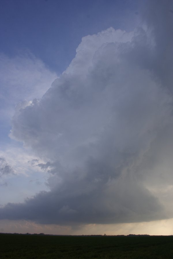
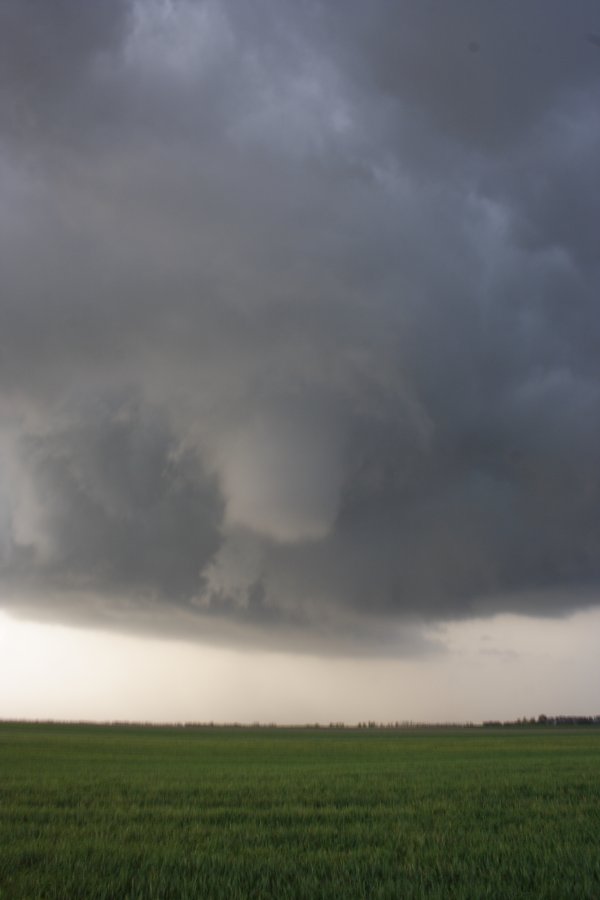
This storm then appeared on the end of the line and began to show signs of getting its act together. The structure was improving and it seemed as though it was moving a little more to the NE now.
http://www.orangepower.com/gallery/displayimage.php?imageid=441
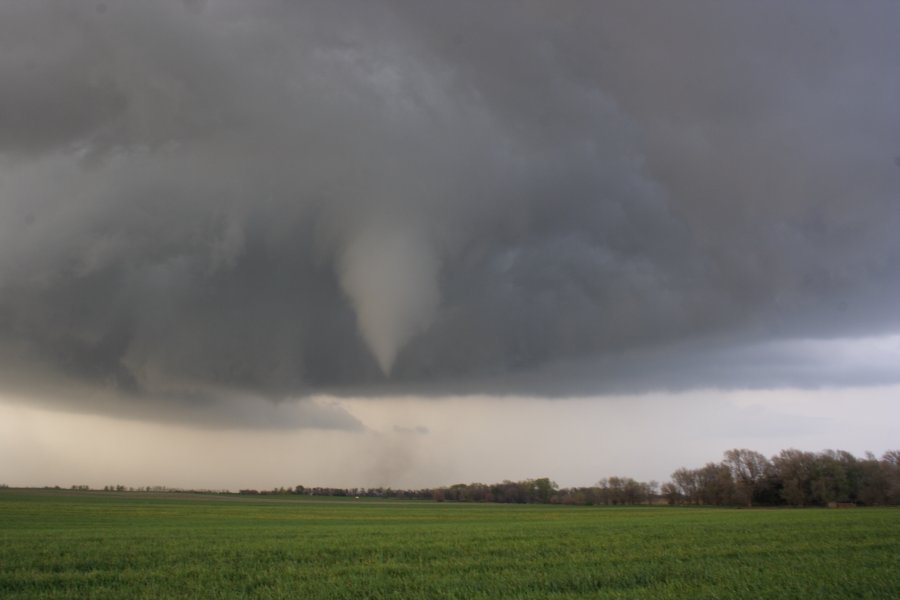
As the storm moved closer and rotation improved, it became a funnel factory for the next 10 to 15 minutes.
[URL]http://www.orangepower.com/gallery/displayimage.php?imageid=443[/URL]
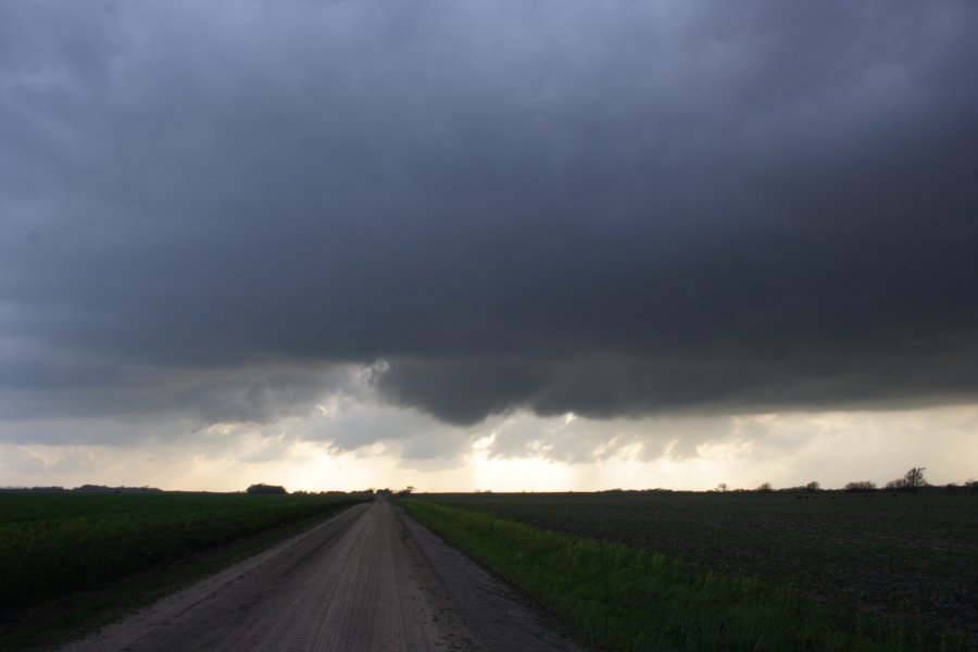
We repositioned a mile north and then the storm really got cranking.
http://www.orangepower.com/gallery/displayimage.php?imageid=442
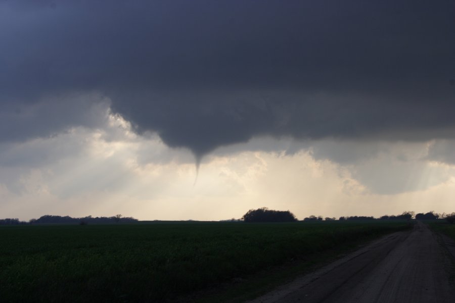
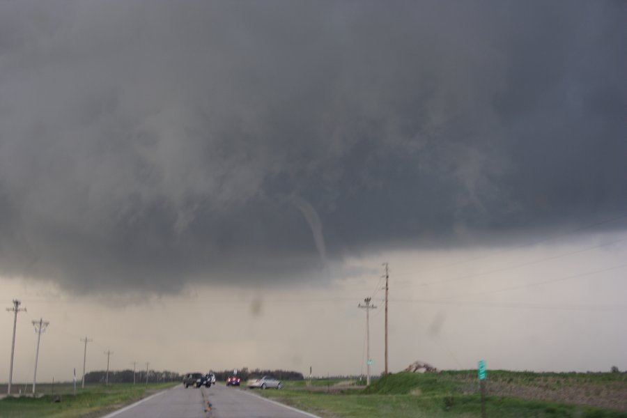
It finally reached the ground within 1 mile to our north.
http://www.orangepower.com/gallery/displayimage.php?imageid=444
It was a relief to see it finally plant itself on the ground.
http://www.orangepower.com/gallery/displayimage.php?imageid=445
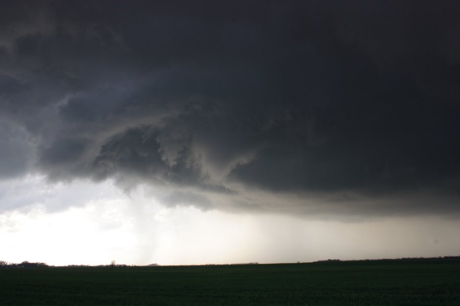
The storm kept cranking away as it moved off to the northeast, periodically setting down tornadoes on the way.
http://www.orangepower.com/gallery/displayimage.php?imageid=446
Outflow soon took over and the real fun had subsided.

I do have a question, though. Did anyone see the landspout? As the meso cranked off to the northeast, only me and a couple of other people remained this far back, but at one point I looked up and noticed a nice landspout well behind the main area of circulation, as it had already passed quite a few miles to the northeast of my position. This landspout was due north of me on the western fringes of what little meso was still left in that area. It appeared and dissipated all within 30 seconds or so. I reached into the car to get the Nikon and it had evaporated before I could get a pic of it. I did get about 15 seconds of it on video, here is a capture of it.
http://www.orangepower.com/gallery/displayimage.php?imageid=447

All in all it was a fantastic chase despite that bastard of a squall line that scoured the area earlier in the day. But I finally got to meet some other chasers, including Tim Marshall, so that made it just that much better.
 
Last edited by a moderator:
Back
Top