4/2/2006 REPORTS: IA/IL/MO/AR/TN

Joined
Mar 15, 2005
Messages
51
Location
Scottsdale, AZ
Chasers Ryan Pfannkuch, Adam Nunnikhoven, and I left Ames around 11:30am and headed for a preliminary chase target of Ottumwa, Iowa. We stopped at a hotel on the north side of the city around 1:30pm for wireless and by 3pm noticed the arc of convection beginning to form south of Omaha towards Kirksville, MO.

The first tornado warnings in our chase area began occurring around this time one county south of Des Moines, where small rotating storms began to form right on the low. However, we played the higher instability to the south and east and it ended up paying off. A tornado warned storm, part of a broken line, crossed into Davis county Iowa at around 3:30pm.

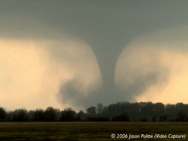
We set up our position on HWY 2, roughly 5 miles SE of Bloomfield, IA and we noticed a rain free base with a lowering quickly approaching from the SW. After only about 10 minutes we were amazed to see a cone funnel cloud extend halfway to the ground two or three miles away from us and then learned law enforcement reported a brief touchdown in this area around 3:46pm. We watched the cone funnel dissipate and then were forced to continue east on HWY 2 due to the precip core blocking our view. The decision to move east was a good one as a new funnel formed over HWY 2. We had trouble viewing it however because we were battling RFD winds of 60-70 miles per hour that was battering the chase vehicle.

This problem somewhat subsided however once we reached a north route, county road V42. We traveled north through the town of Pulaski with the funnel clearly visible to our west. It extended closer and closer to the ground as each minute passed. We took one more turn on county road J40 east from V42 to stay out of the path of the funnel. This was a another good decision because two to three minutes later we watched the needle like funnel become a rope tornado and cross V42 close to the intersection we turned east to get out of. A nice debris swirl was visible as it crossed the road. We reported this tornado on the ground to the Des Moines weather office at 3:57pm.

We followed the storm for another 45min after this but never saw it produce again, despite numerous tornado warnings issued for strong rotation. Overall, a very good chase day.

P.S. We figured we would drop off our video at KCCI Des Moines so they could add it to the local storm coverage on the 10 o clock news. Couldn't believe what happened next...we were asked by CBS This Morning to buy our video. Must have been a slow news day I guess!.. but hey it will pay for gas money. Best of luck to everyone else who chased today and the last week. I hope this is a sign of better things to come...

Ben McMillan

Iowa State Grad, Fall' 05, and Iowa area spotter and chaser

[attachmentid=71]
[attachmentid=72]
 
Fabian Guerra and I had our first bust of the year. We loitered around Hannibal, MO waiting for more discrete activity in the warm sector and were presented only lines with embedded supercells instead. We crossed back over the river and attempted to head off the northern cell of a line to our south that had a sloppy hook and a flying eagle signature. We couldn't beat the storm and got hit by some quarter sized hail. Everything congealed into a line at this point, and, despite the dozens of tornado warnings, that was it for us. A tornado wasn't necassary to make the chase but we saw absolutely no storm structure today and thus it was bust city for us. We still had fun, though. Fabian took my job of getting the obligatory S*** on the video when the large hail started to smack us. We also wound up chasing via ferry boat, which was quite amusing. Seven of us met up at Daphne's Diner n Lincoln for grub, swapping war stories... it was a good time.
 
I started from Princeton, MO and made my way to Lancaster, MO and waited there for storms to fire. Storms started firing in Mercer Co., MO and points south at approx. 3 PM. The storms that were rushing at me in Sullivan and Putnam Counties looked linear in nature, so I decided to head east, away from them at this point to give them more of a chance to be in the better environment. I headed east to Downing, MO and then North to Bloomfield, IA. 1 mile south of Bloomfield, weather radio notified us that Davis Co was now under a Tornado warning. I stayed in Bloomfield for several minutes waiting for the hail core to pass. A volunteer fireman stopped by to tell me that two tornadoes had been reported on the ground 3 or 4 miles south of town. After the hail core had passed I went east 2 miles and spotted a funnel cloud NE of hwy 2 approx 1 mile. We chased this storm for approximately 6 miles until we were 7 miles North of Pulaski. It was at this time the storm finally decided to let its small white funnel come down to the ground. It was on the ground for approx. 3-4 minutes before it roped out in western Van Buren County. The wall cloud then reorganized and was producing more funnel clouds in Van Buren Co. We traveled North to Douds, IA to try to keep up with this storm, but we finally decided to quit after it was traveling to the NE faster than we could keep up with it. A video (not good quality) and pictures from today are on my website.
 
Well......one word sums it up...bust. One of the most frustrating days I've EVER had. What i DID was, travel through 6 counties that had touchdowns later in the afternoon, to get to where nothing much happened. I was in St. Louis, and went up to Bowling Green, MO. Radar indicated a tornado,funnel, but no warning. THEN, after it hailed, the warning WAS issued, but saw nothing. Of course, had I not gotten stuck in the mud, maybe I would have been further down the road to where i should have been. Luckily 4 guys on 4-wheelers pushed us out. Had I stayed in Mt. Vernon, I would have been ok too, but.....that's chasing. And get this...the guy who chased with me, left Sangamon County Illinois to meet me, and a tube touched down THERE..1.5 miles from his house, while we were stuck in the ditch in Bowling Green, MO. On the way back to South Carolina, I plan on stopping by the several counties that had damage to what happened. Most folks can't wait to tell you there stories, and i really do want to hear them all. So, after 1,008 miles, and 450 still left to go, two major traffic jams, (Atlanta, and I-85 North of Atlanta), getting lost, and then stuck, it's a bust. I hear Kansas/Missouri may be back in the hot seat later in the week, and i can't wait!
 
4/2/2006 REPORTS:AR

This report will be very matter-of-factual. I’m tired, although exhilarated. It’s late, but I’m still high. This was the best tornado-day for me in over a year and a half.

Jason Politte and I witnessed four tornadoes in east-central Arkansas today thanks to dedicated nowcasting from Scott Blair. We began chasing as an initial storm went up and we caught it north of Plumerville, AR. It looked high-based but it did have a wall cloud. Time was 4.04pm.

http://www.onthefront.ws/images/4206v1.jpg

The storm got away from us as we navigated some tortuous roads up to Searcy. We gained ground miraculously on it and were dumbfounded to see a pale-blue cone aloft on the western flank of this now impressive supercell. It writhed about for some time and at times was halfway condensed to the ground. We could not confirm ground contact although the rotation was impressive. Time was 5.15pm.

EDIT 6/3/06 7.00am: KARK just reported on yesterday's event and showed video of this Searcy feature. They also showed resultant damage and reported that it was on the ground. I am therefore calling it our first tornado of the day yesterday.

http://www.onthefront.ws/images/4206v2.jpg

http://www.onthefront.ws/images/4206v3.jpg

After this event we continued to Bald Knob, AR to follow this same storm eastwards. Hwy 64 became our highway for the rest of the afternoon and evening. We drove in heavy rain and some quarter-golfball sized hail. After getting gas in Fair Oaks and talking to Scott B. on the cellphone, it became apparent that our initial storm was accelerating too rapidly to catch and that we should drop west and target a second supercell that had developed south-west of our storm and had just tracked over Searcy with a nice-looking couplet.

Dropping south briefly from Augusta we observed some large hail to baseballs just on the edge of this healthy cell, went east to Grays and back up to Hwy 64. We drove east in constant anvil precip and small hail while keeping an eye on this new cell. It looked fairly high-based and lazy with an impressive core. After a while of keeping ahead of it we stopped at a gas station for a bathroom stop in Wynne. Time was 6.04pm. Scott B. maintained that this storm had a hellacious couplet on it and had from the start – yet we couldn’t see anything that looked imminently tornadic.

While proceeding to exit from the gas station, I spotted a finely-defined and backlit cone aloft to our south-west. We hauled butt south with the video camera rolling on 64S as the tornado fully condensed RAPIDLY. This storm exhibited no RFD, no wall cloud and the ambient supercellular updraft base was very high. This tornado resembled the Beaver City May 22nd 04 tornado although smaller. It was a high-based tornado. We stopped just north of Wynne with some good open fields and filmed and took stills as our highly-backlit cone matured into a straight-edged stovepipe and fattened with a handsome debris fan at its base. It persisted for at least ten minutes. Time was 6.50pm.

http://www.onthefront.ws/images/wynnetornado1.jpg

http://www.onthefront.ws/images/wynnetornado2.jpg

http://www.onthefront.ws/images/wynnetornado3.jpg

wynnetornado4.jpg


http://www.onthefront.ws/images/wynnetornado6.jpg

http://www.onthefront.ws/images/wynnetornado7.jpg


Instead of navigating through Wynne with a tornado on the town’s doorstep we shot back north and east again on our Hwy 64 to Parkin, AR. We dropped south on 75 here to catch one last look at the base, but after seeing it through rain and hail and experiencing some very interesting winds we were ready to call it a day and head home. We gassed up in Parkin again and began talking to some locals about the Wynne tornado…

…Five minutes later a laminar tube became visible hanging out of the backside – northwest side – of our storm, from the old, fully occluded meso. We scrambled after having been admiring the spectacular anti-crepuscular rays with rainbow and dropped south to get a view of this ghostly, pale-blue tube, fully planted on the ground, snaking down from the backside of a ragged-looking, nearly-spent updraft tower. Absolutely spectacular. Time was 7.28pm. It dissipated quickly after we had it in full view.

http://www.onthefront.ws/images/Parkintornado1.jpg
(Tornado is to the right of the road behind the power lines and connects to cloud base in upper-center portion of image.)

It was dusk. To the east of our dissipated surprise another new, mean-looking meso was cycling. About ten minutes later we were stopped on the side of the same highway after having navigated some downed power lines and the odd piece of debris filming in the last of the dying light as our new meso to our east developed another ghostly-pale cone aloft which fully condensed to the ground in the twilight and persisted until we lost sight of it in the darkness and precip. Time was 7.41pm.

http://www.onthefront.ws/images/separkintornado1.jpg

separkintornado2.jpg


What a spectacular chase. Sudden departure, frantic driving, stellar nowcasting from the best out there, and an ultimately rewarding chase day which will be damn hard to beat.

Karen
 
Also a very frustrating chase today for me, although it was partially my fault. I was in Ames IA yesterday visiting my girlfriend, but I figured we'd be pretty busy so I left my laptop and maps at home. Didn't even think twice about it, as I noticed the SPC bubbles were moved a little farther SE than they had originally been. But then, Polk county went TOR warned so I decided to go out blind and see what I could catch just by listening to the 2m HAM and NOAA. I probably would have seen something, I was in the right place, but it was WAAAAAAAY too foggy to see anything at all. I was really disappointed. That combined with the fact I had NO clue where I was, just a general Idea and my direction of travel. NOAA reported a cell producing a tornado that traveled up from 12m east of DMX, and was to be near 6m W of the city of Baxter at 1800CST. Miraculously I found myself 7m W of the city of Baxter at 1800. There very well could have been a f5 tornado nearby, but it was SO FOGGY I couldn't see past a couple hundred feet at best.

Anyway, blind, lost, no technology, and fog made for a pretty boring waste of gas.
 
This is all over the place post, but maybe some of the info can be combined with other's to form a more complete picture; I didn't really mean to chase any storms, but after being in a major traffic jam on I-44 in Missouri, from Rolla-St Louis area, I couldn't help but observe.

I left Salem, MO about 2:15, headed towards I-44. Massive thunderheads were building, and by 3:00 the sky had darkened in the distance.
From 3:15-5:00 I was stuck between the St. Clair and Lennox (? I believe...) exits on I-44. There were periods of heavy downpours, small dime-size hail, and extreme amounts of lightning.
Meanwhile, around 3:30 I got reports from family in Salem about 50MPH wind gusts that took out power, and by 4:30, there were (measured) 81MPH wind gusts that wreaked havoc on lawn furniture and simple farm structures.

Later, I got a few of those "out-the-car-window" shots on I-55, about 6:30ish, around Litchfield, IL;


Basically, I wish I had been at the Salem farm to observe what kind of action occurred there, but my trip home to Illinois proved rather interesting, nonetheless.

-Jennifer
 
First and foremost, my prayers go out to all those who lost loved ones and /or suffered injuries during yesterday's events. Having an F3 take out a large part of Utica, Il. in 4/04, missing my house by a few mere miles, I sympathize with all those affected.

As far my results, I had my sons b-day party, which ended later than anticipated. I figured the best chance I had to catch the line just crossing over from MO was to catch it mid state. Therefore, I hightailed down I-39 down into Bloomington area where I was able to intercept it just SE of there. Sat with a deputy, trying to determine (through the lightning flashes...dark at this time) whether or not I was observing the most vertical piece of scud I had ever seen, or in fact a thin funnel cloud coming down quite far (we were tor warned at this time, approx 7:20 pm). Nice lowering base. I came to the general consensus that I was indeed witnessing a funnel cloud (maybe all the way down, but I could not tell from my vantage point) and that was confirmed as the deputy was quick to respond to reports of tornado damage in (or near) Saybrook, which was where this funnel cloud looked to be heading.

I stayed put, was blasted by 60 mph winds, saw a very nice light show, and headed home.

A bust? Not so much. Could have been better. It's also April 2nd in Il. There will be better days.
 
No dice for me and my chase partners Rich and Ryan Thies. We attempted to get in front of the tornadic supercell which came out of the Mark Twain Lake area southwest of Hannibal MO. Unfortunately, before we could make move to get in tight with the circulation, the hailcore slammed us in the town of Detroit IL (Pike Co.). We took shelter under a car port fearing a solid golfball hail core would soon be upon us. It started out small mostly nickel and dime sized. Around 4:50pm, the hailcore really started to hammer the area. No golfballs, but quite a bit of 1-1.5" hailstones. The downer was that this supercell tracked towards Springfield IL and into the higher low level shear near the warm front and seriously spun up. We were done though as the supercells raced away from us. We listened to all the tornado and wind damage reports coming out of St.Louis and figured the big jet max had hit and the storms were off on a rocket speed course away from us. I returned home to see that some big nasty supercells had tracked across N.Arkansas/MO Bootheel and were now in Kentucky and Tennessee. Of course the second guessing of my earlier chase target of Quincy IL soon came into play after reading all those nasty storm reports. I guess maybe if I had not been out so late returning from the chase Saturday, maybe I would have seen that signature of strong tornado parameters Sunday morning. It looked like finally the deep moisture met the strong deep shear Sunday. All I have to really say is that it's April and it's Arkansas (I am kinda surprised that Oil Trough was not nailed as usual). Kudos to Karen Rhoden and Jason Politte for a good NE Arkansas chase.
I am sure Arkansas is back on the radar for chasers to flock to after this event. I know I'll be watching it a hell of a lot closer now !!
 
Thanks for the kudos, Brian. :D

Just some housekeeping....

I have posted our full chase account (well - as full as it's gonna get) with large-sized video captures on the following page:

April 2nd 2006.

My Blog post on the event (which is identical to the link above) can be found here:

Blog post on April 2nd 2006.

Also, NWS LZK's great page on the severe events of recent including April 2nd 06 can be found here:

Severe Weather March/early April 2006 by NWS LZK.

(Readers will be relieved to know that we managed to avoid the Folgers-style hail. B) )

Karen
 
When I saw all the storms rushing towards my town, I got quite excited, not knowing it would consistantly lack in every area.

RAD looked like this:
193gg.png


This was exciting at first, I thought I would see a shelf cloud or roll cloud or something and then get some awsome lightning, but it didin't happen. It started interacting with the complex terrain of the mountains or something, and lightning stopped soon enough, only a few were displayed.

img57100gg.jpg


img57205bs.jpg


img57199yd.jpg


I headed around town for thirty more minutes, and got out on a construction site, where it was flat and very elevated. I got winds of up to 40 mph, it even blue my canon on the tripod over. I then got pounded with very large rain droplets.


Another round of storms were coming my way though, and would be here, arouns 2-3 AM EDT.....I decided to wait it out to actually see if I would get to see something worth while or not. And I did. I looked out my window and saw flashes lighting up the anvil, and I waited until it was just right next to me, and I walked onto the porch, and there hanging in the sky was a large grey, rugged gust front, moving at incredible speeds, being illuminated by lightning, so I had to bump up the ISO so that the exposures wouldn't be as long to light the scene, since it was moving to quickly, it moved over my head from about 1 mile away in 3-4 minutes, after so, rain and wind started slapping me very hard in the face, winds in the 50's I'd say. Then some nice lightning, and loud, loud thunder.

img57417cq.jpg


img57425nf.jpg


img57436kq.jpg


img57485fw.jpg


img57503yn.jpg


img57510mp.jpg


I was pretty please when I went to bed.
 
I departed Nashville at around noon on Sunday. Intercepted the tornadic line around the STL metro area near 5 p.m. Shot the following pics looking W from I-255 near Casyville, IL. There is a suspicious darkening beneath one of the gust front kinks on the right side of the pics. I belive this was probably a gust-front spinup, as this line produced two F0s and an F2 about 30 miinutes later and NE of this location. Pic quality is not great, and contrast is low...

StLouisGustFront0_a.jpg

StLouisGustFront1_a.jpg


Shortly after I took the pics, the gust front overtook me with severe wind gusts, and small hail. I tried to get back in front of the line for about 30 minutes, before finally giving up and heading S.

As I drove S, I witnessed the towers from the tornadic supercells in AR moving into W TN. As I approached the MO/AR border, a new line blew up and passed directly over me, dropping small hail. I stopped at a rest stop on the AR side of the AR/MO border and snapped some pics of a nice lowering as it moved away from me to the E. I was using a digital camera with no shutter control, so it was just luck that I managed to get one lightning-illumnated pic of the lowering with two apparent funnels. Time was around 9p.m. CDT. Second pic is just a blowup of the region of interest in the first pic.

ArMoTnFunnels_Full_a.jpg

ArMoTnFunnels_a.jpg


Called it quits on a frustrating- and unfortunately deadly- day after this last encounter. Congrats to Karen and crew for some nice shots of the AR tornadoes. I busted twice in Bald Knob in 2003!

TonyC
 
Great report and photos Karen and Jason. In Guy, (20 miles NE of Conway, AR), we got hit with hail with both the supercells originating in Conway County. The first covered the ground with quarter to golfball size hail at 416 PM CDT and the second dropped golfballs at 445 PM. The stones were still on the ground at 6pm with many still near quarter size. I also heard several reports of baseball size hail about 5 miles northeast of here with stones shattering on impact. I did not see visual evidence of a wall cloud or funnel cloud, but the greenish hue was definitely there.

Damon Poole,
Skywarn Spotter
Guy, Arkansas

[attachmentid=108]

In the picture - These hailstones were taken from my front yard at 600 pm CDT on 4-2-06. Almost 2 hours after they originally fell! Some of the stones were still as large as quarters despite some melting. Golfball added for scale. ....Poole
 
My apologies for the lateness of my reply ...

I communicated with several members on the Stormtrack board of the bow echo line that was passing through the metro St. Louis area to the immediate west. I was perched on my apartment balcony and across the grounds to get the shots of the gust front blowing through the area.

The pictures are located here:

http://www.atmos.uwyo.edu/~sipprell/bow_echo_storm/index.htm
 
Back
Top