• While Stormtrack has discontinued its hosting of SpotterNetwork support on the forums, keep in mind that support for SpotterNetwork issues is available by emailing [email protected].

4/13/07 DISC: TX

We did have an additional 10 minutes that we could have possibly gotten back had we not stopped for gas in Stamford, but I'm not sure how much that could have helped us, and it's 20/20 hindsight. At the time we wanted to top off right before the main chase activity began. That approach is standard and makes sense. At this time we didn't feel like we were behind anything so there was no motivation not to stop.

Apparently this was a Kobayashi Maru scenario similar to that faced by Tony Laubach back on May 12th 2005 to the fact that it seems unwinnable. http://en.wikipedia.org/wiki/Kobayashi_Maru This refers to the original unwinnable test scenario presented to Capt Kirk in Star Trek 2 and historical to other doomed unwinnable situations.

In retrospect I believe we could have intercepted this cell but it would have taken going north to Throckmorton initially from Albany where instead we took hwy 6 more directly to the storm. I will note that approach didn't seem all the intuitive at the time, and only in hind sight after much analysis and reflection does it make sense.

I welcome any other comments, suggestions, alternatives, observations any of you might have.

Either way it was a fun chase and we at least were in the thick of it. Perhaps I'll post my short clip showing the wallcloud / funnel I taped off hwy 277 to the east of us.
 
Possible Tornado in Parker County, TX, SW of Springtown.

Pardon me for posting in here something other than the Seymour, TX tornado but since this is a dicussion thread about the storms in Texas on Friday, I thought this would be the appropriate place. Very interesting information so far on the tornado.

As listed in my chase report in the reports thread for Friday, I stated that we happened to be in, what we believed, to be a start of a tornado NW of Ft. Worth. This was on the particularly nasty squal line that went on to cause the tornado in N Ft. Worth. When this squal line was in Wise and Parker counties, part of it was tornado warned at the time for rotation spotted by spotter and NWS radar. While we were attempting to outrun the storm, we began to see a rotating base, about 1 - 2 miles SE of Springtown, TX, and just to the S of our location. About 4 -5 miles to the SE of Springtown we lost the rotation over the car. It was at that point we began to encounter violent, what I would call rotating winds. Our vehicle began to get pelted with pebbles and any light debris in the area. Any loose dirt in the area began to get lifted and swirled off the ground. Wind was not only buffeting our vehicle around but the surrounding vehicles that were getting knocked out of their lanes. I have no doubt in my mind that the circulation we had seen in the sky had extended to the ground, and had officially become a tornado. It couldn't have been more than an EF1 but still a tornado no-the-less. After reviewing time stamps on my photos of the funnel (right before we got buffeted), the time was 22:32Z, and just 1 - 2 miles SE of Springtown. The closest radar scan was 22:34Z with our location being 4 -5 SE of Springtown and the time we started encountering the ground circulation. I have included images of the radar scan below. My question is, was there anybody else around that area at the same time I was that happened to see anything? I know Jeff Snyder passed through the area just to the west of where this occured around the time we were in the Springtown area and noted the numerous mesovorticies associated with this line. I'm sure some of the local residents saw what took place. There were numerous houses around there and numerous people out and about. What do you guys think?

My Storm Report:
http://www.stormtrack.org/forum/showpost.php?p=131439&postcount=14

Here are three radar captures from the 22:34Z scan. I've outlined the spot where we were and witnessed the ground circulaton in the 0.5 Degree Storm Relative Velocity Scan. If anybody has better radar imagery, feel free to post it please.

springtown_radar_velocity_outline.jpg


springtown_radar_3.jpg


springtown_radar_velocity_05.jpg
 
Last edited by a moderator:
Bill, I don't presume to speak for Tony, but, as I mentioned, and as you can see from his images, our vehicles were less than thirty five feet apart. Tony was south of me on the road at the moment that my GPS shows us stopped 5.98 miles south of Seymour. So, unless my GPS was wrong, Tony was about 5.981 miles south of Seymour. That's the position from which we both observed the tornado. Your graphic shows Tony north of the tornado track when we were actually both south of it as it crossed the road.

I don't think Tony and I disagree on any positioning or track estimates. Tony, correct me if I'm wrong.

Yeah that was based on Tony's original statement. I put it on the chart before you reconciled the locations. Plus I can't put them too close together or those map tags overlap. As for the textual mention you're quoting I was just writing down what I got out of the other posts and he logged it that way.
 
My position though not close was certainly close enough to observe (5 miles nwest of thockmorton was my location on a dead end dirt road) at precisely these times - Bob Shafer was nowcasting for me and has confirmed the timing. Also my wife was with me confirming the visual.
While I was not in perfect photo distance, in hinsight I should have slapped on my zoom lens, but didnt. All I can say is that my visibility was perfectly clear at the time. What I saw was round and huge, even at this distance. (dont know the true distance but it was almost due north/a little north east).
What then distracted me was what was coming straight at me, punching through the clouds(obviously a new small cell formation).
So my options were to grab this lowering and book it out the 79.
(north northeast) - 2 hopes: to grab what I had in front of me and/or to possibly intercept THE seymour wedge as the road was more favored. Distance meant I was probably gonna miss the wedge.
I have some photos of what then happened heading out the 79, relative to my position it was just above and north.(not the wedge) Numerous red dust swirls a fast moving (fast) wall cloud (just over of me about 5 miles out of throckmorton) and an impressive funell formation with a bears cage. We had to outrun this as it crossed behind us.
The rotating picked some up debris and started to turn very brown at the base. But funneling none the less. We then were forced north through a detour and all I could see was a black mass that we followed for some time north that never really cleared out.(probably the then Seymour now rainwrapped event)
Ill try to post the few pics from down south of my cell in a few days.
If anyone wants some more on this pm me.
 
Last edited by a moderator:
A week ago there was a thread on "counting tornadoes" and I had some comments that apply here. For years I kept records on many aspects of chasing, including why I busted on a particular day. Forecasting issues are the least of the reasons why I bust, it's more often something that happens in the field that leads to failure on a particular chase, and it was this time.

When I kept statistics in addition to counting tubes I counted large hail, times I chased on dirt/mud roads and so on. One persistent reason I missed tornadoes, or missed good photography jumped out of the numbers. That is, falling behind the storm or trying to chase within the RFD. I like to do this because the tornado is front lit, that is it has color, it's not just a sihouette. Some storms you can get behind the wall cloud and get away with it, but I've learned getting behind a storm crossing a warm front is bad and generally leads to failure. Warm front storms quickly tend to HP as the LCL falls, or will at least develop a notch with heavy wrap around precip. This kills the chance of photographing the tornado from the west and sometimes from the south. The thinnest amount of rain wrapping around a tornado (visual hook) will obscure it from view if that precip curtain is front lit. This tends to be true of most boundary crossing storms especially if they are not highly sheared. There is another important feature not discussed here. There were two mesocyclones and two different wall clouds. This could be seen early on when the original circulation (brief Rule touchdowns) occluded and a new flank intersecting from the east formed. These east flanks tend to go tornadic fast because they bring more low level shear against the precip boundary of the storm than the SW flank (my opinion). When I saw this structure form I encouraged Bill to drive through the old meso and get east. Bill, after his emergency room experience (glass in his eye) from the 05 South Plains tornado- hail event was reluctant to do this. So we tried to get ahead of the storm going east at Weinert and north to Goree, but the storm had the hypotenuse and we were doomed. The other alternative was to go east at Bomarton, we could have done this but the flooding already on 277 made me reluctent to call that move. Even then, with the tornado somewhat in a notch as shown by the images from different angles we may not have seen it. It appears to me only viewing within that notch or being SE-E of the tornado would have worked on this day. It was not a classic flanking line (Browning model) storm that would lend itself to that kind of chase strategy. In chasing, angle and lighting is everything not distance. There were times we were pretty close to this event, I saw rotating scud and rain curtains, but not the tornado. We just didn't have the angle on it. I can understand why Bill is so frustrated about this, to be so close and miss is maddening, but it's also chasing.
icon12.gif


Gene Moore
 
Does anyone know if NWS Norman will be conducting the damage survey for the Seymour Tornado? It would interesting to know how long it was on the ground and whether it caused any damage.
 
I was doing some research with GRL2 radar data on those tornadic storms, here are some grabs of the Seymour supercell/meso if someone gets interested on them.

19:35 UTC:


19:39 UTC:


Here are some animations;
1) Base reflectivity tilt 0.5°: http://www.weather-photos.net/temp/KDYX_radaranim_level_II-refl_tilt_0.5.gif
2) Base reflectivity tilt 0.7°: http://www.weather-photos.net/temp/KDYX_radaranim_level_II-refl_tilt_0.7.gif
3) Relative velocity tilt 0.5°: http://www.weather-photos.net/temp/KDYX_radaranim_level_II-srv_tilt_0.5.gif
4) Relative velocity tilt 0.8°: http://www.weather-photos.net/temp/KDYX_radaranim_level_II-srv_tilt_0.8.gif
5) Relative velocity tilt 1.3°: http://www.weather-photos.net/temp/KDYX_radaranim_level_II-srv_tilt_1.3.gif

Indeed this was an impressive storm!
 
This first map image shows the zoomed in layout of the chase, with most participants represented, along with their location and time. It also includes the times the wedge was spotted, estimated path, and some of mine and Genes times and positions relative to the developing tornado.

Bill and others,

It would seem the confusion comes from the inaccuracy of my earlier distances estimates. Having examined our GPS file and searched Google earth for our pull-off point, I found it on the NE side of the road just past CR 223 which puts us at 5.45 miles from the 277/114 junction in Seymour when we sighted the tornado. That correlates pretty well with Tony and Amos's data. Sorry for the confusion due to my "rule of thumb" estimates. Emphasizes to me the importance of accurate data gathering.

Gene
WXtreme Chase Team
 
Last edited by a moderator:
A week ago there was a thread on "counting tornadoes" and I had some comments that apply here. For years I kept records on many aspects of chasing, including why I busted on a particular day.

We were actually talking about your post on failure modes Friday morning, specifically how being late is a frequent but preventable problem. It was ironic because when we finished our long lunch at El Rancho in Ranger, we thought we'd made ourselves late by letting the warm front sneak north.

There's no doubt in my mind that if we'd ordered burgers at El Rancho instead of chicken fried steaks (which I've never done before on a chase day lunch), we would have left Ranger twenty minutes sooner and turned west on 380 at Throckmorton, and then northwest on 222 towards Munday to achieve the best angle given where the storm would have been at that time. We would have faced the same decisions as others and missed the wedge.

The reason we were 6 miles south of Seymour at 2:38 PM is because it was our first possible interception point and we barely made that.
 
If you go back and review the radar evolution around the time of the tornado (2:40 pm based on Tony's siting) the storm was undergoing some unique evolution around that time. The tornado looks to have been where you would expect it though - out on the tip of the hook appendage, but immediately thereafter that circulation rapidly tracked northeast while a new core extended to the southwest, later crossing along a similar path, but perhaps that trailing mesocyclone is the one you met as you exited Seymore. Sorry to hear you were on 277 - there was chatter regarding what an unfortunate place that would be to try and navigate the storm.

Hey Glen,

Yeah, I've been reviewing the radar. That is pretty amazing to watch, how the meso with tornado area shoots off, and a new extension shoots back and starts tracking the same way. I wonder what would cause it to behave quite like this? Perhaps related to anchoring on the warm front and continued propagation?

And yes, after reviewing all our positions and times and comparing that with the Street Atlas map, and the radar it was the new secondary meso extension that was fast approaching us from the west. That's one reason we boogied on to the SW down hwy 114 quickly at that point.
 
Bill and others,

It would seem the confusion comes from the inaccuracy of my earlier distances estimates. Having examined our GPS file and searched Google earth for our pull-off point, I found it on the NE side of the road just past CR 223 which puts us at 5.45 miles from the 277/114 junction in Seymour when we sighted the tornado. That correlates pretty well with Tony and Amos's data. Sorry for the confusion due to my "rule of thumb" estimates. Emphasizes to me the importance of accurate data gathering.

Gene
WXtreme Chase Team

Ok, that makes sense. I don't think I'l redo the map, everyone just visually in their mind imagine the chasers locations on hwy 183 and 114 to be a bit further south a couple miles or so. Amos is placed almost right, but should probably be shown a hair futher south IMO too. Imagine the tornado track displaced a bit that way as well.

While making the distance to the east a bit further for our viewing of the wallcloud, we were watching it some although I couldn't alot because I was driving and on the left hand side of the vehicle. I do recall mentioning as we drove that I was seeing rotating curtains of rain around the lowered wallclouds. While we were stopped I got some video of it when it started getting better developed. As I recall it was hanging down pretty good and appeared to have a funnel in the middle starting to form. This could very well have been the formative stages of the wedge. I may post a video grab in a bit.
 
Congratulations to Tim Marshall for his spot on forecast and thanks for that long drive Tim. It is a pity that we weren't able to intercept this beautiful wedge - congratulations to those who were able to.

Here are the latest pictures:
http://australiansevereweather.com.au/photography/photos/2007/jd20070413.html
Serpentine funnel
The mesocyclone that most likely produced the wedge tornado ??

Hail west of Fort Worth falling from the second HP supercell we intercepted - near Eagle Mountain Lake

Regards,
Jimmy Deguara
 
There is another important feature not discussed here. There were two mesocyclones and two different wall clouds. This could be seen early on when the original circulation (brief Rule touchdowns) occluded and a new flank intersecting from the east formed. These east flanks tend to go tornadic fast because they bring more low level shear against the precip boundary of the storm than the SW flank (my opinion). When I saw this structure form I encouraged Bill to drive through the old meso and get east. Bill, after his emergency room experience (glass in his eye) from the 05 South Plains tornado- hail event was reluctant to do this. So we tried to get ahead of the storm going east at Weinert and north to Goree, but the storm had the hypotenuse and we were doomed.

It's true, there were two meso's initially. I've been examining all this stuff in detail on radar, Street Atlas, and pictures. As we were leaving Haskell and looking west we saw the lifted dust with weak circulation. I'm pretty sure that is what was left of the Rule tornado. It was part of an extended flank that wasn't as strong and didn't have the heavier radar echo of the area to our NW at the time. As we were racing north, this area of rotation paralleled us for awhile. I remember looking out the window at the small wallcloud with small extending funnel and mentioning it to Gene. :) 
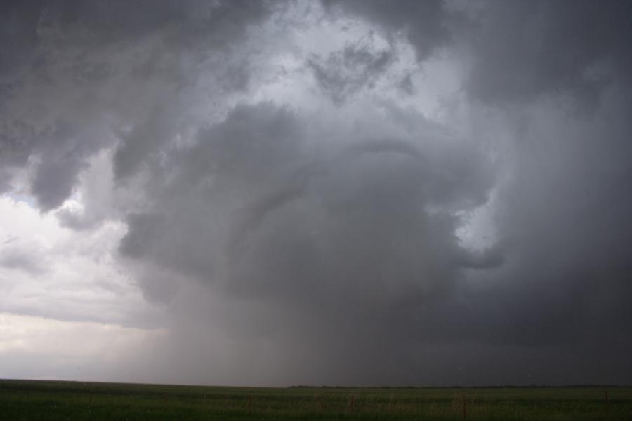
He just said to ignore it. But I remember it did have a fair amount of rotation, but he was right I could tell it wasn't the big fish. I didn't slow down for that though. I began slowing down as the lowered wallcloud area to our NW, and then NNW began wrapping with a huge amount of precipitation and occluded. It got so thick you could no longer see the lowering, but it was a very intense, turbulent area of wind / rain, and who knows what. I thought it was a possible developing tornado, and said so. It was such a large area we were already in the wrapping rain especially as we continued north. I remember Gene said something like 'Let's go, we've got to get up the road', and I replied 'In front of...into that?' - :eek:
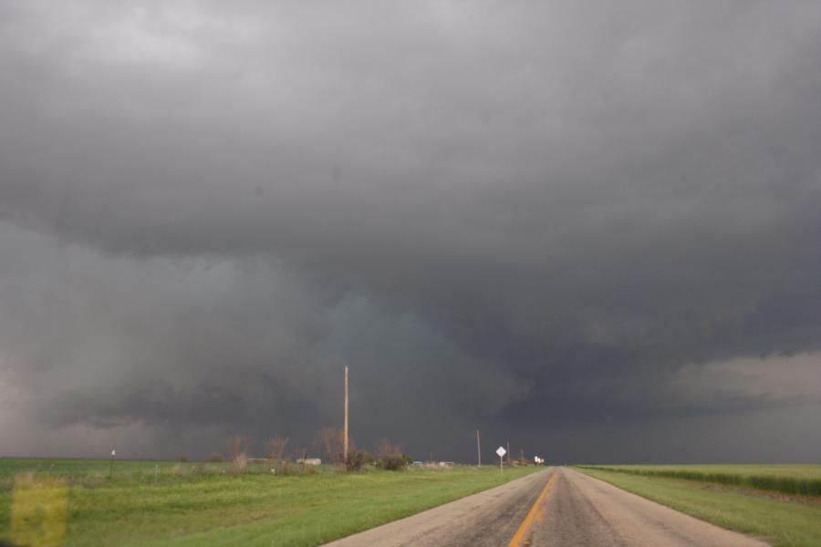
. This is the area that had a big inflow band feeding into it from the east. I did continue, but at a bit slower pace than 70mph. Basically at this point the area of rotation that would eventually become the Seymore Wedge was passing in front of us. I continued on until Gene suggested we observe for a minute. After that we went a bit further north, and realizing we had no time or likely success going through that core / meso we turned east on 1720. The whole time we were alternatively riding under or near the hook as it progressed more or less to the NE. Pretty much the whole time that area of rotation tracked parallel hwy 277 offset by about 5 miles or so.

But no, I appreciate Gene's sentimentality, but the South Plains hail incident didn't have much to do with it. I wasn't worried about hail, but a tornado instead. Also for everyone's info (I meant to post something earlier), turns out I don't believe the spot of blood in my eye that day was due to glass. I forgot I get that sometimes in my eye. Not often, but occasionally where one of those blood vessels ruptures. It's no big deal and just goes away after a week or so. Likely that day with all the stress it shot my blood pressure up and caused it to happen. - I was wondering how my eye could have been cut with my hail goggles on (although they were hanging kind of lopsided in the confusion).

The other alternative was to go east at Bomarton, we could have done this but the flooding already on 277 made me reluctent to call that move. Even then, with the tornado somewhat in a notch as shown by the images from different angles we may not have seen it. It appears to me only viewing within that notch or being SE-E of the tornado would have worked on this day. It was not a classic flanking line (Browning model) storm that would lend itself to that kind of chase strategy. In chasing, angle and lighting is everything not distance. There were times we were pretty close to this event, I saw rotating scud and rain curtains, but not the tornado. We just didn't have the angle on it. I can understand why Bill is so frustrated about this, to be so close and miss is maddening, but it's also chasing.
icon12.gif

Gene Moore

Yeah, when I was playing around with Delorme and routing at home at one point it created a route from Bomarton over to hwy 183. I'd say with the hail melting and all there was probably a pretty good chance it was flooded. Plus being a secondary road and covered under hail it might have been a bit slow going mostly in 4wd. Also looking at radar and Delorme it appears to be pretty lined up to pass directly into the developing wedge. Gene's a wild man though he may have been able to pull it off. :D Most likely he's pulled off something similar numerous times before.

Angle is important. This is probably a perfect text book example of the importance of being in the notch as you mention. Here, the other chasers were afforded a brief glimpse of what the storm was carrying with it. Even Bill Mudd many miles to the south believes he could see it, but not in the detail he wanted. That might lend some credibility to the notion of taking the long way round as we might have been able to see some of the wedge action from a distance from the SSE - not sure. It may not have been close enough for either of our preferences though. Plus in the images this tornado seems very low light, and low to the ground.

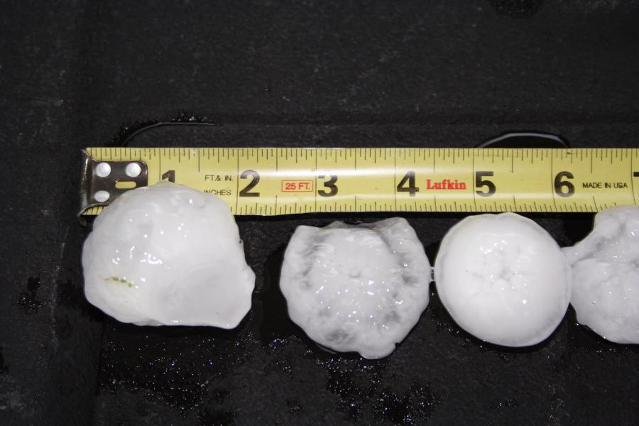
I have to admit, it was thrilling to ride under the hook. At least we really got to taste the storm, and feel it's pulse. We also did get some good views of the hail and the wallclouds. The wallcloud I shot with video (as I recall) came out fairly impressive. Hmm perhaps being on that Bomarton road would have let us sneek up behind and - at least close enough to view it somewhat?

Anyway, it is frustrating to some degree, but I've also been finding it fascinating to look at the pictures, radar, chaser accounts, and map locations and finally have an idea of what fully transpired as well as what situation faced us. I was intrigued to know what the options were, and if they were really workable options. In my opinion, I really think once we exited Haskell and started north we were basically cut out from seeing the tube. As I recall Tim Marshall was in a similar situation with our route, but perhaps a minute or so ahead, and he didn't fare any better.
 
Dal Archer, that was some amazing sounding audio and screaming inflow you had there. What's your best guess on your position? I'm thinking perhaps it was near the same area toward the end of Amos's Youtube posted video where it starts wrapping up and getting completely hid in precip.
 
Back
Top