4/03/06 REPORTS: NC/SC/VA

Matt Robinson

I stayed close to home for the late afternoon central North Carolina setup, expecting to get at least some decent photogenic lightning if nothing else. Unforunately for me the line approaching downtown Raleigh at sunset promptly collapsed into a fierce gust front before encountering the city. Among very strong winds (six stories up, it was hard to stand upright), little to no lightning occured where I was and almost no rain. The system pretty muche sustained itself to the north and south and even reformed along to the west along the new boundary created from the gust front, so it was almost as if my position jinxed the whole thing. I did at least capture the shelf cloud encroaching downtown Raleigh:

raleighdt_shelf_1_4206.jpg


The sun managed to illumate the base of the clouds on the other side as it set:

raleighdt_shelf_2_4206.jpg
 
I am working in Rockville MD this week. I am just north of DC.

I was out for a walk earlier and noticed that the atmosphere had some potential I assumed that the action was south of here in Georgia and the Carolina's. I did not have quick access to internet and was unaware of todays potential so I stopped for dinner.

Stepping out after an hour of dinner I saw an impressive slow moving cell moving overhead. The cloud base was nice and low, the cloud had that nice deep green and blue color due to the hail. Inflow was consistent. No rotation of any consequence. I was torn between running into the hotel to my laptop and the internet. I noted the enterprise car rental office across the street and weighed my options of an impromptu chase. No camera, no recent data, just an extremely nice storm right over head.

The cloud was rather picturesque as it was about 6 PM and the sun was at a nice angle.

After waiting for some development or rotation and getting nothing I headed for the hotel. Got blasted by a cold downburst and some strong winds and the hail looked like it was on it's way. Not having good access to a sheltered place to observe I headed into the hotel to get some data.

Seemed like I spent the day in an area of decent potential. I was actually glad that the storm did not develop as I was in the middle of a populated area.

--
Tom Hanlon
 
Myself, Mike Strickler (NWS Raleigh), Paul Suffern (NC State), Zach Brown (NC State) and Patrick Pyle (NC State) chased a classic supercell (well, as close as you can get in NC) from Central Robeson County to E of New Bern NC before losing it to sunlight and the road network. Storm really never had strong cloud base rotation, but did exhibit many terrific classic supercell qualities, including a lowering, beaver's tail, mammatus, and at least one RFD occlusion (whcih I'll have to recheck radar and make sure).

We left RAH once the agigtated CU field SW of town finally got an echo aloft. Going SE on I-40, we begin to see the two cells off to our S. The southern cell became dominant, and we raced down I-40 hoping to beat the core before it crossed I-40. As we got closer, classic supercell appearance emerged with hints of a beavers tail, nice mammatus, and backsheared anvil.

100_0205.jpg


We barely got through the core on the N side of Warsaw, NC in W Duplin County. Once we were out of the precip, we emerged very nearly just about in the updraft region...and we did have some rain curtains rotating around. Then, the updraft/persistent lowering crossed I-40.

100_0210.jpg


100_0211.jpg


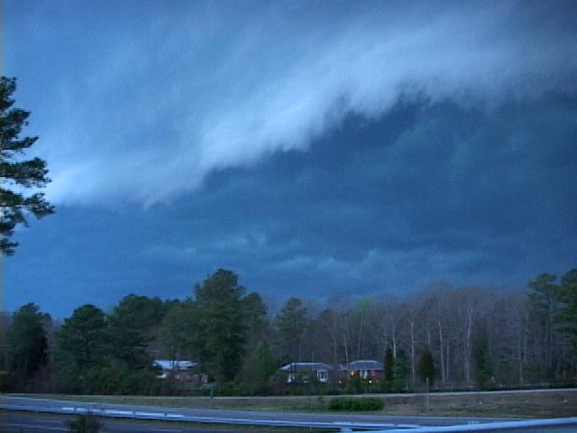
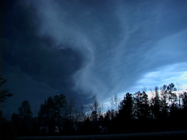
The first pic is taken looking NE, and the second pic is taken just to the left, showing the edge of the updraft. Cloud based rotation was pretty minimial, but there were defintley scud tags getting ingested. This probably was the only real attempt at a tornadic phase...low level shear was pretty non-existent and the storm was extremely high based. The veering surface flow, coupled with mixing of dry air to the surface raised our LCLs, effectively cooling any RFD and subsequently killing our tornado chances. Had the surface flow stayed back, LCLs been a bit lower, and more streamwise vorticity been ingested, who knows.

We then proceeded to chase the cell E to the coast on Hwys 41, 55, and 70 before losing it E of New Bern.

100_0222.jpg


Anvil on the sup.

100_0228.jpg


Convection E of our cell along the coastal front.

100_0230.jpg


The view from the SW, and a bit away because of the road network.

100_0240.jpg


Nearing the end, heading E on 70.

All in all, a very rewarding chase considering we are in SE NC! :) Seriously though, I saw alot more than I expected. Though, I wonder if our low-level flow hadn't veered out...we might have had a shot at tornadogenesis E of Warsaw. The road network in E NC is as bad as anywhere in the country for chasing, and despite frequent battles with trees, once we got out on the coastal plain, things were pretty visible. It's like catching T-Rex in the jungle down there, and considering we didn't leave RAH till 5pm and got back about 1015pm with eating, a fairly short chase. Of my ~55 chases, this is my first "true" chase in NC..not too bad :)

Special thanks to Shane Young (FSU) and Dr. Michael Brennan (NHC) for nowcasting and NWS Raleigh for updates while in their CWA. Sorry we ended up not sampling the hail core ;)
 
I was quite hopeful for April 3, with a Moderate Risk across SE Virginia and eastern NC. WIth an approaching trough, good upper level support and backed winds, I was sure there would be a potential for tornadic activity. My inital target was Roanoke Rapids, NC to the VA/NC border. I left work early and drove to Emporia where I met up with Bill Coyle and Jesse Bass III. We watched WX Worx and checked data from a nearby Wi-Fi. I was even more optimistic when a large tornado watch was issued for almost all of Virginia and North Carolina. With an area of SE winds, increasing instability and clearing, I decided to wait. I thought this was a good position. We watched a LINE of storms form to the west. I was hoping for initial discreet supercells but no such luck. An area of better instability with localized increased CAPE (supercell index bulleye) formed to our south but it was too far away to reach before dark. I also didn't like the veering of the surface winds in that area. An isolated storm formed in that area (south of Greenville), at times appearing supercellular.

With approaching darkness, I decided to head north and intercept the leading edge of the squall line to shoot some lightning and test my equipment. Bill and Jesse also headed north. The images below are just south of Petersburg.

Full report will be posted on my website.

040306storm1.jpg


040306storm3.jpg


Bill Hark
 
Awesome. I love the eastern shore. Anything can happen. And although we lined out here in the red box, my buddy and I stumbled upon a small pearl. Prepared for a linear car wash, we opted to sit facing west on the MD side of the big river. As the squall began crossing over the King George Bridge, a small section bowed and the northern edge began actively rotating.

Gustanado? Tornado? Waterspout? Anthrax? Or just plain outflow? Don't matter to me - the classification is trivial. It was gorgeous.

020.jpg


021.jpg

022.jpg

023.jpg

024.jpg
 
Well I am always late putting up reports and since Bill Hark pretty much covered our chase day which I dont know if I would call it a chase day buy hey east coast stuff is not the alley that is for sure. I just wanted to put up a photo or two... The first is the incoming shelf/gust front and the other is lightning near the town center of Virginia Beach, all shot were taken with the Nikon D200 which I am still learning where all the controlls are...Thanks for looking


[attachmentid=120]

[attachmentid=119]
 
Back
Top