3/12 Storm Structure

Joined
Dec 8, 2003
Messages
2,208
Location
Kansas City, Missouri
Was just curious about some of the things others noticed concerning the structure of the storms on Sunday. One thing I noticed was the lack of anvils for the most part - is this a product of the cold environment aloft? - Dan Chaffee's photo of the Sedalia megastorm really shows what most all of the storms looked like as far as upper structure is concerned. It's interesting because they had such intense, perfectly defined cores on radar, but I'm thinking the tops didn't really push that high. At low levels there was tons of precip (at least it seemed to me), and a person had to be in the clear, away from any wrapping rain or hail, to get a view of any rotation. I would classify most of the northern storms as HP even from the way they looked at ground level. Just wondering if anyone else had any similar (or not) observations concerning storm structure on Sunday -

(PS - mods, this can be moved if it's not in the right spot ... sorry if it isn't ... still getting used to the new digs here)
 
I observed the storm that would eventually become the MO bomb from about 60 miles to the SSW of it. Needless to say - while in northern Oklahoma/southern Kansas and watching it ("it" being rocketing northeast at 55kts or whatever the storm motion was) - we didn't have a chance to catch it. However - I must concur with your assessment Mike of the general storm structure and/or physical characteristics from afar. This storm - being the amazing tornado producer that it was - was interesting to look at. It had a massive, massive dome which is generally a good indication of atmospheric explosions going on. The dome would pulse of course with each pulse of storm intensity. However - the anvil was less than noticeable unless I just don't remember it. Put it this way - you sure didn't see the classic, knifing, hard edged anvil of many May/June type storms. I don't know why. Why? :blink:

As far as any of the other convection that fired in our target area of SE KS on Sunday - storm structure and its associated convection looked like poo-poo. Underneath a milky band of cirrus just before dusk that line of grunge formed (that later also gave birth to the NE OK/NW AR/SW MO nighttime supercells and tornadoes), I watched towers and congestus go up that looked more akin to the beginnings of a pathetic <500CAPE March squall line than the beginnings of another round of nighttime tornadoes. They were either anvil-less or had very strung-out, string-bean looking anvils, the convection was for the most part generally soft and glaciated, and a lot of the time the towers would turkey-out, being far taller than they were wide. Once the storms formed around dusk, their cores and bases were generally a ramdom collection of cumulus base and precip. - with the bases very high and linear-looking. Really bizarre. Anybody have any idea *why* these things looked like crap, and not only that - but also went on to rearrange in NE OK into amazing tornadic supercells?

As an aside - it's a pity that our moisutre mixed out and we experienced so much subsidence behind the late-morning area of convection in SE KS. While blasting north out of Tulsa, I visually observed the area of subsidence and mixed-out moisture. It was very evident (and worrying) to see that our lovely, tornado-sky-looking low cu that we had had along I-40 all day had turned into somewhat-shallow-looking cu with much higher LCLs and much of the cloud cover had seemingly bled over into the mid-levels rather than stayed in the low-levels.

K.
 
sedalia.jpg


This was the first Sedalia storm looking to the south at the time it was putting down the tornado. I agree, most cells lacked anvils on 3/12.
 
Saw plenty of anvil downstream of the storms across central MO. In fact, as I recall anvil extended well into northcentral IL even at mid-afternoon. One thing I did note was that back-sheared anvils were only periodically present even with the 'mega-cell' during the evening hours at least. Given the regional soundings gave a tropopause height of ~ 11-12 km in the region, storms would have been somewhat stout relative to what you might see in late spring, but the 100+ knot flow at the tropopause height, with only about 2500 CAPE, was probably more than enough flow to 'vent' the storm anvils down shear. As for storm structure - the next northern storm relative to the Sedalia storm in the Columbia, MO area had a blend of HP and classic structure as it passed over Centralia, MO with an inflow band coming in from the southeast and a long beaver tail extending northeastward, and flanking line extending well to the southwest attached well northwest of the inflow band. Cloud base was particularly low - but I think the storm was just starting to have problems ingesting outflow from the Sedalia storm (though it did still produce apparently a short time later). After dropping south to the southern-most cell southeast of Mexico, at the time that storm also had an HP type structure - with the vault region expanding over a vast distance. Certainly some interesting structure with this cell - particularly as it crossed central IL with three reflectivity appendages extending off of the storm (say around 0400Z). I imagine there will be a lot of mets studying this event.

Glen
 
karen your description of those storms in the early stages was right on! heres what the nws tulsa had to say about their "transformation"

MESOSCALE UPDATE...TWO SUPERCELLS CONTINUE TO TRACK ACROSS NORTHEAST OKLAHOMA...ONE EXITING ROGERS COUNTY...THE OTHER IN WESTERN WAGONER COUNTY. BOTH STORMS HAVE BEEN LOW-PRECIP TYPE STORMS AND HAVE BEEN UNDERGOING SPLITS AND THE NORTHERN SUPERCELL HAS BEEN IMPACTED BY PREVIOUS LEFT SPLIT CELLS. THE STORMS ARE MOVING INTO THE 850 MB MOISTURE AXIS AND SEEM TO BE TRYING TO TREND TO A MORE CLASSIC LOOK. WIND PROFILES REMAIN VERY FAVORABLE FOR TORNADIC SUPERCELLS AHEAD OF THE STORMS.

Both of those storms looked pretty crappy for a couple hours but right after they moved across hwy 75 they took off. The southern storm (that eventually spawn the benton county, ar tornadoes) was very LP. There was no lightning and very little hail/rain and then in probably about 20 minutes it went to constant lightning and looking much more classic. I called a tv met and he was comfiming the reflecitivity and VIL was rising fast every scan! You can see the pics here: http://realclearwx.com/3122006.htm
 
Unless I am dyslexic (which is entirely possible) the most interesting storm structure I observed was an anti-cyclonic rotating thunderstorm. It never dropped a tornado and didn't last too long but it was interesting to watch roll over me. As far as rating the "violence" of the rotation on a scale of 1-10, I would give it a 2, but the structure was neat anyway. Here are two pics of me looking toward the SW as the storm was moving NE. The radar grab is from the KTWX Topeka/Alma radar to the NW of the storm.

IMG_4697_1.jpg


IMG_4700_1.jpg


RANTOULANTICYCLONE.png


The red dot East of Ottawa is my location. Full size images can be seen here.
 
karen your description of those storms in the early stages was right on! heres what the nws tulsa had to say about their "transformation"

MESOSCALE UPDATE...TWO SUPERCELLS CONTINUE TO TRACK ACROSS NORTHEAST OKLAHOMA...ONE EXITING ROGERS COUNTY...THE OTHER IN WESTERN WAGONER COUNTY. BOTH STORMS HAVE BEEN LOW-PRECIP TYPE STORMS AND HAVE BEEN UNDERGOING SPLITS AND THE NORTHERN SUPERCELL HAS BEEN IMPACTED BY PREVIOUS LEFT SPLIT CELLS. THE STORMS ARE MOVING INTO THE 850 MB MOISTURE AXIS AND SEEM TO BE TRYING TO TREND TO A MORE CLASSIC LOOK. WIND PROFILES REMAIN VERY FAVORABLE FOR TORNADIC SUPERCELLS AHEAD OF THE STORMS.

Both of those storms looked pretty crappy for a couple hours but right after they moved across hwy 75 they took off. The southern storm (that eventually spawn the benton county, ar tornadoes) was very LP. There was no lightning and very little hail/rain and then in probably about 20 minutes it went to constant lightning and looking much more classic. I called a tv met and he was comfiming the reflecitivity and VIL was rising fast every scan! You can see the pics here: http://realclearwx.com/3122006.htm
[/b]


http://realclearwx.com/images/312006101.jpg

That is a very awesome picture
 
Anybody have any idea *why* these things looked like crap, and not only that - but also went on to rearrange in NE OK into amazing tornadic supercells?[/b]

I was in se KS at the time the second round formed around 5pm... I agree, the updrafts certainly did NOT look like they had 2500 j/kg CAPE available. The shear was very strong, obviously, so I think the smaller updrafts had a VERY difficult time sustaining themselves, thus the "pulse"-like look to many of the updrafts in that area. I don't think the RUC mesoanalysis had a very good handle on it (not to mention, it showed very little CINH remaining in an area of moderate sfc convergence by around 3pm, though it was noticeable from the field that the cap was certainly holding -- I hate that 'capped cu' look). With that said, I'm not sure how much I trust it's CAPE analysis either. However, a look at the 0z SGF sounding shows only -17 j/kg CIN, which is certainly breakable with any real convergence (that's a weak cap). So perhaps it was more of an issue of weak convergence along the dryline as winds veered a bit ahead of it than it was an issue of too strong a cap. Of course, this a balance between capping and convergence, so we can say too strong a cap for the given convergence, or too weak convergence for the given cap.

<div class='quotetop'>QUOTE("Karen")</div>
As an aside - it's a pity that our moisutre mixed out and we experienced so much subsidence behind the late-morning area of convection in SE KS. While blasting north out of Tulsa, I visually observed the area of subsidence and mixed-out moisture. It was very evident (and worrying) to see that our lovely, tornado-sky-looking low cu that we had had along I-40 all day had turned into somewhat-shallow-looking cu with much higher LCLs and much of the cloud cover had seemingly bled over into the mid-levels rather than stayed in the low-levels.

K.
[/b]

I agree... I think the forecasts from the RUC and NAM both showed 65-70 Tds in se KS, eastern OK, western AR and western MO by afternoon. However, many of the OK Mesonet stations in ne OK were in the 59-60 range by afternoon. Certainly, this led to high LCLs and higher LFCs. In fact, with such strong shear in place, I think the high LFCs (~3000m on the 0z SGF sounding) may have strongly helped to inhibit initation, since any would-be updraft may have faced very strong entrainment as the strong environmental flow impinged upon it.

Some of the 'storms' reminded me of the March 17th chase in NE TX last year -- the LP supercell that was overly sheared, but did finally produce a tornado near Paris. The updrafts on Sunday looked like that covered more horizontal area than vertical area... It seemed to take a while for the storms to establish their vertical perturbation pressure gradients, which then lead to stronger updrafts (perhaps much stronger given the amt of low-level shear and vorticity ingested into the updrafts).

I have seen "no anvil" supercells on other chases as well. On 8-9-99 (my first chase), the first supercell I chased produced a couple of tornadoes, during which time I could not see any sort of anvil -- the supercell just looked like a pile of convection. I saw this with the 10-29-04 mini supercell in eastern OK as well.
 
Was just curious about some of the things others noticed concerning the structure of the storms on Sunday. One thing I noticed was the lack of anvils for the most part - is this a product of the cold environment aloft? - Dan Chaffee's photo of the Sedalia megastorm really shows what most all of the storms looked like as far as upper structure is concerned. It's interesting because they had such intense, perfectly defined cores on radar, but I'm thinking the tops didn't really push that high.
[/b]

A couple of comments:
As Glen mentioned, the significant, longer lived storms definitely had anvils. They were blown
downwind before they had a chance to expand outward near the updrafts. This, in my experience
is not at all unusual for early Spring storm environments with very strong mid and upper level
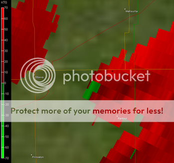
winds and lower equalibrium levels (tropopausal heights) --see the pic below
that shows a segment of the anvil the Pettis Co cell and the updraft/anvil of the supercell
to its N. Since an anvil is essentually where the condenstation has no reason to rise
any further (excepting directly over the strongest part of the updraft), it must either
spread out along and underneath the equalibrium level and overturn ('knuckles") or
be blown out of the way at a greater rate than the lifted condensation can expand to replace it.
The latter seems more the senareo in this instance. As with most aspects of storm morphology
there are multiple factors that determine how any part of the storm appears, so it probably
isn't just the speed of the upper winds, but I'll bet that played a big part.
2supercells.JPG


The storm I showed yesterday (Pettis Co at the time) started to backshear its anvil a few
minutes after I headed back. Around the updraft, he anvil was amazingly thick--about
10,000 to 15,000 ft thick (or more!) and purely cumuliform along its western and southern
edges. The morphology of this storm was somewhat different than what I saw at the southern
end of the convection entering the SW KC metro area at 2:20pm CST, where the updraft was
highly sheared over, more than 45 deg from the vertical. The longer lived storms had more
robust, nearly vertical developement as they matured.

I recall another storm back in 1995--the "I-70 Supercell" that had a surprisingly
wispy anvil near the updraft at times, during its long lasting mature phase, with it looking
broader considerably further downwind. The winds aloft were fierce with that event as well.
 
A couple of comments:
As Glen mentioned, the significant, longer lived storms definitely had anvils. They were blown
downwind before they had a chance to expand outward near the updrafts. This, in my experience
is not at all unusual for early Spring storm environments with very strong mid and upper level
winds and lower equalibrium levels (tropopausal heights) ...

Dan's onto part of the relationship between anvil shape and upper-level winds. Rather than the absolute winds, it's the storm-relative anvil-layer winds. The stronger those winds, the more likely the anvils will not build upwind given the same updraft strength. There's also a relationship between storm type and storm-relative anvil layer winds (anvil SR flow). Rasmussen and Straka established some skill in discriminating LP, CL, HP storms by their anvil SR flow where HP storms tended to have values less than 35 kt and LPs tended to have them more than 72kt. The 12 March environment was more like the upper ranges. There are caveats in that the storms they investigated were isolated and didn't have very long flanking lines. If you've got storm interactions where one storm seeds another with its load of precip then any storm can go HP no matter the anvil SR flow. The dewpoint didn't have much relationship to storm type at all and that makes sense to me.

BTW the anvils Sunday were mostly strung out downwind but there were a few storms that built anvil upwind. Most storms that were as sheared over as they were on Sunday tend to take a long time before reaching tornadic maturity but when they do, they don't stop as long as they don't run into bad air or interference. I was mentioning to somebody that you'd have to be 1.5 hours downstream of these storms to have a chance of seeing a tornado whiz by. But I way underestimated it. Most took almost 3 hours.
 
I took this photo at 6:40pm CT in Moore, OK...I am looking east in this photo, the storm was developing over the Shawnee, OK area...This storm would later produce the 1/2 mile wide tornado in NE Oklahoma, before moving into Arkansas and Missouri...Looking at the radar, the storm appeared to survive for at least 8-9 hours...

100_0064.jpg
 
Heres a time lapse video (17 minutes) condensed into about 20 seconds showing a storm and anvil developing. This is the storm that moved just south of Tulsa and into extreme NE OK and SW Missouri (the next supercell up/north from the Benton County, AR cell. Taken from about 6:20 to about 6:40pm near Beggs, OK looking W then NW.

http://www.realclearwx.com/drylinevid.htm
 
Unless I am dyslexic (which is entirely possible) the most interesting storm structure I observed was an anti-cyclonic rotating thunderstorm.
[/b]

Was this around 2230Z? If so, I did make a short nowcast regarding this storm here at around that time. It indeed looked to be a left-split (anti-cyclonic) supercell, so your observations are probably correct.
 
Back
Top