3/11/06 Reports- Midwest and southern plains

Joined
Feb 19, 2004
Messages
1,375
Location
Erie IL
Just got back a bit ago. I was surprised there wasn't a reports thread yet....


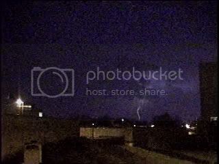
Left the house around 4pm, and headed south on I-74. About 20 miles north of Galesburg we saw this tower go up and try to get going. Nice twist to it, and it looked like it could explode; but after a shortwhile it collapsed.. Looking west-southwest


Drove on into Galesburg, and found ourselves under this nice, broad rain free base. Inflow winds were blowing into, so we had hopes that this thing could do something. Looking southwest


However, a short while later, the thing went totally HP. The updraft base became completely obscured by rain and hail. We drove a bit north to avoid getting hit by what looked to be the powerful core... Looking southwest


Well, no such luck. This thing was flying and we were overrun by the core. At first, just very heavy rain; but after a short while, hail. Hail grew from marble sized to ping pong ball sized. Needless to say, my buddy's heading to the insurance adjuster sometime next week. :cry: looking north


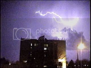
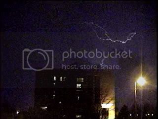
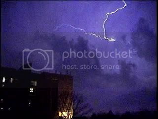
It didn't take long for the ground to be whitened, but luckily the hail didn't grow any larger. After the hail ceased, we followed the storm north again; but this thing was flying! Here's a shot as it pulled away and began to enter Henry County IL. looking northeast


The storm just pulled further away, and with nothing else catchable we decided to call it a day. Did catch a decent sunset though.


All in all, it was a fun day. Didn't have to drive too far. Watched much of it develop overhead in my own backyard before hitting the road. I feel bad about the hail damage, but I guess that's just a price you have to pay sometimes when chasing fast moving storms early in the year....
 
Had a somewhat eventful day today, and took a friend of mine on his first chase (Jimmy Buckner). We left my house around 1:30ish and followed the first cell that moved through Benton County; it had a very nice white lowering and ironically had a rainbow under the center of rotation. As the storm moved deeper in to Carroll County and Missouri the roads became to windy for us to keep up with it and it also became too forested to see anything effectively. As a result we headed north to Springfield, Mo, and sat there for a while until a cell moved out of MacDonald County and towards our direction. It became Tornado warned and it had a very well defined wall cloud over Hwy 160. We followed the storm only to see the wall cloud erode and become rain wrapped. WE had to cut our chase early today, when our driver (Andrew Rugzie) had to return home due to a family emergency. It still looks really active out their and I am going to watch it from my comp, and hit the hay early to get ready for tomorrow. Sorry I don’t have any pictures, my camera is out of commission and I will have a replacement by next week.

Edit: Also I forgot to note that on each storm we came across areas that were covered by either nickel or quarter sized hail.
 
It was a figure 8 route for me today with Locust Grove, Ok. the cross over point. Started in Tulsa to Locust Grove to Tahlequah to Muskogee up to Wagoner back to Locust Grove then North to to Jay, back down and west to Locust Grove and home..anyway not much to share since timing was off much of the day. I was able to intersect with one cell coming into the northern part of Wagoner, Ok and stayed behind it to Locust Grove but by the time I made it to Jay it was almost across the State line. At least I am assuming it was the same one (no radar).
I've put a couple pics below , I decided to add a blog to my website for this year so the rest can be found there http://stormdriven.com/cblog/

4:39 pm N. of Wagoner Ok.

IMG_1588.jpg


Tree still smoldering from being struck?
treefire.jpg
 
Very nice thunderstorm for mid-March in Green Bay, WI. Beat last year's first good storm day (3/30/05) by a good 2 1/2 weeks. I took lightning video from the same place as I did that day. If anything today's storm was even more electric! :D

03-11-06Storm1.jpg


03-11-06Storm2.jpg


03-11-06Storm5.jpg


03-11-06Storm6.jpg


03-11-06Storm8.jpg
 
Left out of Marion to intercept branson Mo. Supercell. Couldnt believe it held together, anyhow Conditions seemed right with temps at 73 dp's at 68 we plotted intercept near Chester IL. At rt 3 I was speaking with NWS PAH & it intensified very quickly. He told me last scans while still near fredricktown looked very impressive & be careful
We heard the report of spotter confirmed large violent tornado heading just north of Chester. We approached very slowly where vivid lightning we could see base plus funnel. Was large bell shape wedge. We couldnt see with trees but paid very close attn. to tv in vehicle as we manouvered around toward steelville we was south of a very destructive tornado about 2 miles. Foreward speed was at 30 or 35. We pick it back up near Berau {I think thats how its spelled}. Still on ground now after 20 min. Heading for wall cloud now 3 miles out we hit damage path to SW of huge wedge on ground. easily most intense Ive ever seen. We was in awe of that beast. Poles were gone some power lines were blocking our chase. we could still smell the transformers burning. Arrived a few minutes after it passed our location in Perry county on hwy 150. Then just like that two more sups were orientated w-e trailing. I told the ems guys to pull back there were more on the way. sure enough, they crossed very close. we picked up on second storm which at one time there was 2 tstrong tornadoes on the ground roughly 10-15 miles apart. Both viewable just east of Pinkneyville IL. Then cought a glinpse of nice wall cloud with a rope hanging out! 4 tornadoes on 3 hours...Incredible. The large wedge Ill never forget. Completely visable even at night. What a night. Just feel bad for the folks in MO. Possibly IL. Now I need sleep for round 2 today
 
[attachmentid=3] Saturday was a pleasant chase. Met up with Fabian Guerra and Skip Talbot as well as some other Illinois chasers.Waited for things to fire in Jacksonville,IL. Jumped on the first cells near Quincy and followed one NE past Rushville. Looked great initially but mantained a high base and looked to be weakening the farther NE we traveled. Did a 180 turn around when Fabian got a call from another chaser (thank you ,don't remember your name) reporting a butt dragging wall clound on the next cell down the line. Boogied south, once we got close enough I could make out exactly that image. Skip and Fabian decided to drive farther south while I planted and waited for the wall cloud to come to me. I filmed for a while until Skip rolled up and yelled quarter size hail was right behind him. We headed north to keep an eye on this cell but darkness was catching up on the day. All in all a fun day of Illinois chasing. Good roads and no rivers to cross as well as storm motion was not as fast as expected. Link below is video of this storm.

Creative Jetstream

Jerry Funfsinn
http://www.creativejetstream.com
 
I started the afternoon taking some Cb pics around the STL area. Everything kept falling apart so I decided to head north out of STL toward Bowling Green or Hanibal to intercept the line of storms that was training toward the Quincy/Hanibal area. I went with the tornado warned storm at Bowling Green and followed it east into IL via Hwy 54. Twice I saw narrow lowerings but couldn’t positively identify their nature due to the amt of precip. After watching the storm for awhile and playing with some hail I headed back SW to STL since some tornadic storms were heading towards my mom’s county (Jefferson). I hung out at her house monitoring the storms from there till early the next morning. I didn’t want to chase that new string coming through since it was night and the area they were going through is hilly and wooded.
 
Back
Top