• While Stormtrack has discontinued its hosting of SpotterNetwork support on the forums, keep in mind that support for SpotterNetwork issues is available by emailing [email protected].

2026-03-10 REPORTS: IL/IN/IA/OK/TX

Joined
Jan 14, 2011
Messages
3,658
Location
St. Louis
I got on this storm west of El Paso, IL and stayed with it all the way to Knox, Indiana. I observed four tornadoes: Pontiac and Kankakee, IL and near Wheatfield and Toto after dark in Indiana. The tornado at Kankakee was the most significant catch of the day.

Full chase log is here:

Pontiac, IL
march1026d.jpg

Kankakee, IL
march1026c.jpg

march1026b.jpg


Wheatfield, IN
march1026e.jpg

Toto, IN
march1026g.jpg
 
Last edited:
Myself and Andy went for the storms in northwestern Illinois, starting near Galesburg. The storm we were under had a horseshoe-shaped updraft for quite a while, including a pronounced lowering in which the clouds were moving rapidly (grey triangle in the photo), but it never produced a tornado.
1773239886978.jpeg
I suspect the surface-level air was too cold here. When the storm initiated we were slightly to the south and the temperature was just over 80°F, but here was mid-60s (according to the car's thermometer).
 
The RAP kept showing pretty favorable supercell conditions in Oklahoma so I chose to stick around and chase here. Went down to Chickasha and was at the OKC cell when it was a turkey tower. The other chaser convoying with me had car trouble and I stuck around trying to help him out, missed the tornado and didn't get onto the storm until it was cold and gusty. Air conditioner went out on the car too. Followed the storm east to Meeker before sitting in a parking lot contemplating life choices
 
Traveled down to Wichita Falls, TX when storms began to initiate and eventually latched on to one near Holliday. Followed it across the Red River, over to Walters and eventually ended up near Duncan. This was the first supercell I've chased in years where I felt as if I had the whole storm to myself. Not one chaser was encountered along the way. It was an incredibly enjoyable day even without a tornado.

Photo1.jpgPhoto2.jpgPhoto3.jpgPhoto4.jpg
 
This was my first chase of the season and it was exciting and i was happy about all my targeting and decisions were mostly spot on.
Targeted Dwight Il early as two cells developed south of me. Quickly picked the southern most cell near Pontiac but stayed NE to get in position and away from the hoards. I had to keep repositioning as the cell continually made right turns NE to E. Tornado warned at interception south of Reddick it appeared elevated and was loosing its spunk and then lost tornado warning. Many jumped off. I didnt want to speed off to Galsesburg cells so i decided to stay with this one as it was headed back towards home anyhow thinking and seeing a lot of energy still, and possible tornadic redevelopment.
At Cabery 5:30 i noticed what looked like a possible hook tip forming and by 6 it was obvious a hook had formed and would be warned again.Tornado developed over me just SE of Kankakee and felt the huge updraft rattling my car watching dirt in the field forming. pea sized hail turned to basball sized hail smashed my mirror and windshield as i begin following the cell into Kankakee but had to move south because of the river to cross. I only had one decent pic of the downspout in front moving eastward towards Aroma Park which as i arrived i had to cross many power lines, dodge trees, and witness the devastation of the houses, trees,etc along the river there. stopped to help for a few but moved on east trying to catch up as the tornado was in the dark mostly and long tracked. Finally at Knox In. I gave up as it had been too dark and rain wrapped.

I have some decent video of develpment, hail balls but my language isnt suitable for here..LOL
PXL_20260310_232746330 - frame at 0m11s-4.jpg
 

Attachments

  • Screenshot_20260310-190339.png
    Screenshot_20260310-190339.png
    338.1 KB · Views: 5
  • Screenshot_20260310-181901.png
    Screenshot_20260310-181901.png
    342.9 KB · Views: 3
  • Screenshot_20260310-181516.png
    Screenshot_20260310-181516.png
    321.3 KB · Views: 4
I initially targeted Galesburg, IL due to getting out of work at 3 PM. Cells fired right before 23z but were initially very outflow dominant and clustery. This continued back to the Mississippi River through around 0z as most cells were interacting with the cool side of the boundary. I decided to run back home and noticed more robust warm sector development across northeast MO with favorable parameters. A storm quickly started rotating near Memphis, MO as it moved into southeast Iowa. Though sun was setting I decided to plan an intercept near the river as there is a high bluff in Nauvoo, IL looking directly into the updraft of the storm as it neared Donnellson, IA. Well, I neglected to turn my camera on but the storm dropped two brief tornadoes near Donnellson, on immediately southwest and the other just east as it approached the Montrose, IA area. The storm quickly became disorganized as it crossed the Mississippi River and become outflow dominant.

This wasn't my most impressive chase, and everything occurred after dark, but it was a great way to kick off the season!
Both tornadoes were confirmed yesterday by the NWS: Event Summary: March 10, 2026 Widespread Severe Hail, Some Significant, and a Couple Tornadoes
 
Crazy chase day for me on what was the longest single chase in my 30 seasons (2,148 miles)...

Quick and dirty as I am in the process of doing a write up for my website...
Drove Denver to Davenport the day before, setting me up nicely for the day of; driving two more hours to the Love's on the north side of Normal where I hung tight til the supercell of the day formed. Picked it up early, following it through Pontiac, and having a solid view as it spun wildly in the sky only to poop out the little birdfart, which counts, so on the board in 2026 and keeps the 'seen a tornado every year since 2003' streak live.

20260310Tor1.jpg

This piddled out pretty quick, and I was giving chase to this for a bit, winding around some off-the-path dirt roads to stay out of the congo line that had quickly developed. The storm kinda grew outflowy and not as visually impressive, so I was giving thought to the west cells as well when I came across the hail near Campus. Baseball-plus around there and I took my time, as I wasn't completely on board with the west option as day light would've been low when I got there, so honestly, I had given up the chase in my head, but kept the original cell within range, just in case.

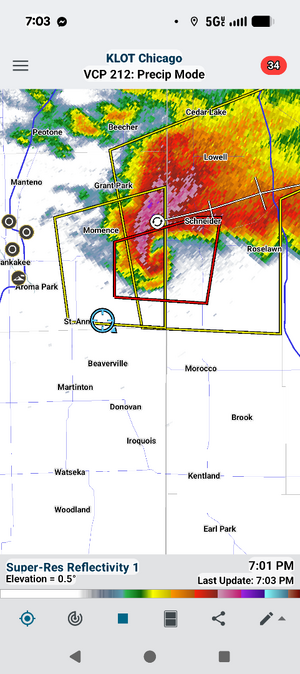
I documented the hail around town, ending up on the north side, and was going to roll up to IL-17 which was the good east/west option for either decision. Well, the original storm was starting to really ramp back up to my east, so I decided to hop up to Cardiff and east on IL-115 toward Kankakee. This was about the time the tornado was starting to develop there in town; I was a few miles west, but could make out the initial tornado before the RFD wrapped it from my view.

20260310Tor2.jpg

My initial plan was to try and get around it to the south and then back up ahead as it was only moving 30-35mph; even my stop in Campus didn't put me far enough behind to TOTALLY miss the tornado, even as I got no definitive captures of it. Initially, my plan was to go through Otto, a road that crossed I-57 a couple miles south of town, but I was quickly hearing about the massive hail reports, and the wrapping RFD had me concerned I would run into significant issues trying to take that route.

So I decided I'd do into town; as I was working, I figured if I didn't think I could get to the tornado, I could make myself useful in town. I knew the tornado had likely missed the heart of the city, but it sounded like the south side was taking damage, and while I wasn't completely aware of the degree of hail, I figured that could also yield something...

649893276_1466558278178822_5003215279362556858_n.jpg

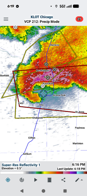
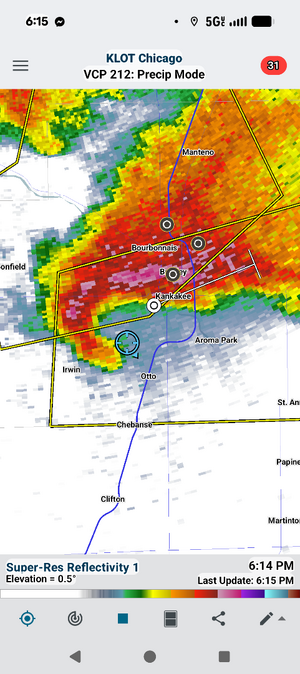
IL-115 hooks north into the southwest side of town, then turns back east near the High School. When I turned the corner, I was FLOORED with what I saw. HUGE hail was EVERYWHERE, and I couldn't pass a car that wasn't destroyed. I decided NOT to repeat TWISTEX 2010 (I think that was the year) in Missouri where we did NOT stop to document hail on a supercell that dumped 5-inchers, and we never got in front of the storm we were after to see a tornado. I stopped and was being Hail Boy again.

HailShot.jpg

I measured a max of 5.25", which I didn't realize at the time WOULD'VE been a state record hailstone. I did a live hit at the High School as the tornado continued on and became a non-starter for me at that point. I couldn't believe I was standing in the midst of all this.

20260310LiveHit2.jpg

I also can brag that I was the first live on scene here. :D

20260310HailSmash1.jpg

Once I got a good grasp of the tornado track and where it went through, I shifted gears to heading to the damage path there near US-52 and I-57; I was unable to get further east, so I did my next couple reports from the damaged industrial area there south of the interstate.

20260310Air3.jpg

At that point, it was well after dark, but a new tornadic line had formed to the west, so seeing as I had done all I could do there in Kankakee, I backtracked west to I-55, and about the time I rolled into Gardner, the storm had gone from tornadic to not-even-severe. I waited it out at the Casey's there in town, figuring maybe I'd get some hail or something, but the storm was a cold-ass version of itself and didn't offer much other than some close lightning and enough heavy rain to turn part of the parking lot into a pond.

So after the storm passed, I saw the third round heading toward Chicago, and it was severe, and only about 30 minutes up the road, so I figured that would be my bunk down spot. I was searching for lodging in Joliet there at the Caseys...

LightningStrike.jpg

And THIS happened about 640 feet in front of my car..

TWO cameras captured this incredible lightning strike, easily the best video I have EVER obtained of lightning, which was close, detailed, and beaded beautifully (the resulting thunder nearly leading to a change of shorts). I do have the lightning video (plus my reaction) on my Facebook page.


20260310_lightningStrike2.jpg

So after downloading the video from the two cameras of that to ensure they didn't get erased, I packed up and rolled up to Joliet just in time to get a breezy thundershower. I called it a night, and made the two day drive home through the wind-driven dust and smoke of I-80.

SOME NOTEWORTHY BULLETS FROM THIS CHASE
  • 5.25″ HAIL: Largest hail I have EVER documented; beating out 2007 in Wisconsin Rapids (oddly enough, my top 2 hail are Midwest states)
  • 2,148 MILES: officially the SECOND-LONGEST single chase in miles of my career; and the third every chase to hit/eclipse 2000 miles.
  • LIGHTNING VIDEO: Closet, most vivid lightning strike I have ever captured. I have had strikes hit much closer, but never captured in this detail)
  • My 'Chase to 500 Tornadoes' got two closer with tornadoes #475 and #476. These were tornadoes #13 and #14 in the state of Illinois.
I will have a full write-up before the end of next week.
 

Attachments

  • lightning1.jpg
    lightning1.jpg
    742.1 KB · Views: 5
Last edited:
Full chase log HERE: Mesoscale Mikey Meteorology - March 10

Quite the day for sure. Me and my team could not leave Iowa till around noon, so we left Ames just before noon with our initial target set to Wyoming, IL. As we got close, we could see what would become the monster Kankekee, IL supercell really starting to pop off. We briefly considered charging after it, but decided not to get baited and second guess ourselves. Three of our friends/colleagues were able to make it in time, and were on the Kankakee wedge, so very proud of them. First real tornado for a couple of them and they did great.

We sat waiting in Wyoming marveling at the exploding supercell 70 miles away, while also watching for updraft towers to our west and monitoring satallite and mesoanalysis. Once the shortwave arrived and western Illinois started to Initiate, we went west a tad toward Victoria, and watched the quick development of a supercell which became tornado warned some time after. I was kinda worried it would cross the front, but it started to look REALLY good so we kept with it and knew we still has the next big storm near Galesburg still in play. Near Kawanee it had amazing horseshoe structure and positive lightning activity was really ramping up. We continue east and north with it and were under the meso for a considerable time, which was sort of uncomfortable, esspecially since it seemed sort of elongated, kind of like the Albany, MO storm on my 4/27/2024 intercept. This made it hard to tell where stuff would drop, or if stuff south of us could hit us while we were moving east, although I could get the sense we were on the central, maybe north side of the meso. Multiple scud clouds and possible funnels teased us, which I tried to grab footage of with the window down while getting my face blasted by meso winds combined with the winds from our movement. At this point, I was also under lots of pressure trying to juggle and multitask, scanning the sky for funnels and tornadoes with the whole mesocyclone right over our heads, filming, monitoring the other supercells to our southwest headed our way, negotiating plans with the team, and relaying and posting critical warning information as an admin for my Kansas City severe weather Facebook group of thousands of people while my own neighborhoods back home in KC was taking hail up to grapefruits with tornado warnings nearby.

As time went on and we gained some ground on the meso, it felt freezing cold so we knew it went north of the front. We enjoyed some nice night elevated structure before heading south for the new storm sarting to anchor to the front it seemed and move east southeast. We got on the storm near Lacon, IL and positive CG and crawler activity was quite dramatic, with mid-level inflow spokes and a wall cloud pretty prominent. An EF0 tornado was touching down and was in front of us the whole time outside of our knowledge, but we did notice suspicious lowerings and a textbook wall cloud with a vivid inflow tail. We then paced it east near Wenona, IL and saw more suspicious things while looking for powerflashes and more tornado/funnel reports were trickling in. A fellow chaser and friend of one of our team members filmed a rope with powerflashes. After leaving the storm to begin the drive back to Ames, we decide to stop in Peru, IL for dinner, and a tornado-warned storm closes in on town right as we arrive. W Culver's.

1773436533818.png1773436608209.png1773436626410.png1773436658580.png1773436671840.png1773436792261.png

1773436710420.png1773436734469.png
1773436817015.png1773436852618.png
 
Kholby Martin and I chased Eastern Illinois on Tuesday, initially targeting the La Salle-Peru area and then dropping south for initial development near El Paso, IL. Documented a tornado near Pontiac, Illinois that lasted a few minutes along with golf ball sized hail. We saw larger hail (at least 3" in diameter) on the ground in the vicinity...then proceeded to botch the rest of the chase by leaving the storm as it looked elevated after the Pontiac tornado.

Headed west and chased another storm near Varna, Illinois that produced an EF-0 tornado, but we had absolutely no visual on, so can't really count that. Easily the biggest bust I've had on a chase where I still saw a tornado but felt defeated afterward. At least the year is still young....


Screenshot 2026-03-13 at 6.13.28 PM.png

Screenshot 2026-03-13 at 6.13.38 PM.png

Screenshot 2026-03-13 at 6.13.11 PM.png

Got back home to Galesburg around 10pm and then I had the hour drive back to Macomb and got back to my home base around 11pm where it was still a balmy 75 degrees out before a weak band of storms moved in and dropped the temperature approximately 15 degrees down to around 60.
 
I'm in the crowd of folks who were on the Pontiac, IL supercell at inception watching it from from a towering cumulus cloud to a full-on supercell without ever leaving the truck stop parking lot. Documented the brief spin-up in Pontiac from a nice vantage northeast of the circulation observing some power flashes within the multiple dusty vortices. Followed it to just southwest of Kankakee where we decided to break off from the storm and drive toward nothing off to our west. I think that's the part about missing the big hail and Kankakee supercell/tornado experience that bugs me the most... I understand the reasoning why I was briefly turned off by the storms appearance and questions about where it was all headed from there, I just think I'd be more okay with my decision to head west if I had actually been heading west toward a new supercell erupting 50 miles to my west. Instead I broke off from the Kankakee supercell to drive west toward a hypothetical round 2 which ended up mostly being elevated hail producing supercells north of the boundary in the cold air. Wasn't that the same reason I suspected I should leave the Kankakee storm? That it would become a hail-only storm on the bad side of the boundary? Anyway, congrats to those who stuck with the storm into Kankakee and beyond.

I've got a complete VLOG from the chase uploaded here:
 
Back
Top