It seems most of the members of Stormtrack are based in the eastern half of the US, so I thought I would post an update on how we've been faring out west this winter...
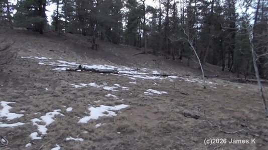
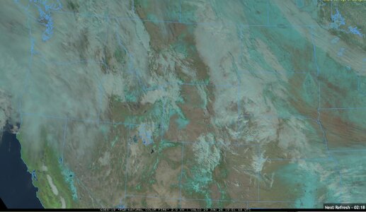
The La Nina pattern this year has been coupled with unusually persistent ridging over the West Coast with only minor exceptions, and it's taken a major toll on snowpack in the Southern Rockies. The cold air outbreaks that have been buffeting the eastern half of the country have also largely missed us here with the exception of the one going on right now.
I'll be mainly examining the period from October to January, as September was reasonably normal here (in the Southern Rockies at least). September 2025 was Denver's first below-average September in 14 years (0.1 degrees below normal-link).
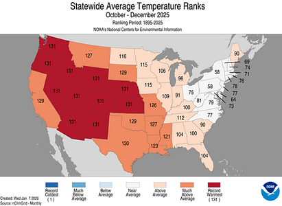
From October to December, persistent ridging over the west produced record warmth for almost every western state. Denver, and many other places, saw the warmest Christmas Day on record. Denver's high on Christmas Day hit 71 degrees, with the previous record being 69 degrees, set in 2005 (link). Mountain towns in Colorado like Vail, Aspen, Steamboat Springs, and many others saw rain on Christmas Day, along with temperatures in the 50s (news article) (data link).
When looking at statewide average temperature from October to December, the stats speak for themselves:
(State temperature/precipitation maps from U.S. Maps | National Centers for Environmental Information (NCEI))
Meanwhile, thanks to a series of robust atmospheric rivers, statewide precipitation across the West was actually at above-normal levels.
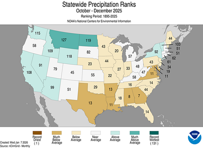
But yet, despite ample precipitation, snowpack across the West is still much below normal. I'm using the latest data from today, January 22nd, for the following snowpack images. All of the following images were generated using the NWCC iMap, which is a fantastic tool for monitoring snowpack across the West.
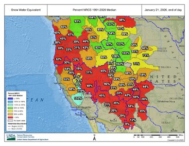
Note: Snow Water Equivalent (SWE) will be the metric used in most of these images unless otherwise mentioned, which for the uninitiated is a measure of how many inches of water would be produced if the snow was melted. This metric is used instead of snow depth because snow density heavily influences how much water content is in the snowpack, and water managers are more concerned about the water than the snow depth. Skiiers would be more concerned about snow depth, and I'll discuss that later.
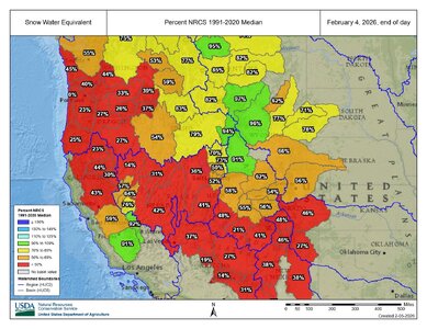
At the moment, SWE is generally much below the 1991-2020 median across the West's river basins, with the exception of a few basins in Montana, Wyoming, and California.
And yet, at the same time, most of the same river basins have seen normal or above-normal amounts of precipitation.
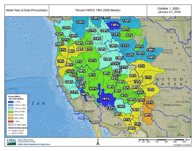
The natural conclusion from these stats is that the precipitation has been falling as expected, but that temperatures have been too warm for it all to fall as snow. This has potentially drastic implications for the upcoming summer's river levels, especially in the Colorado, Platte, Arkansas, and Rio Grande river basins. Snowpack also has an impact on the summer fire season, and a poor snowpack combined with a warm summer can increase the likelihood of fires. A discussion of the importance of snowpack as opposed to rain can be found at the following links:
A Warmer Spring: How a Changing Snowpack is Altering Colorado’s Environment | Sustainability | Colorado State University
Understanding Snow - Water Education Colorado
SnowTrax - Home
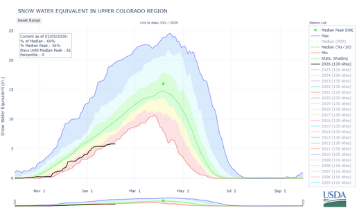
Speaking of the Colorado River, Snow Water Equivalent in the Upper Colorado Basin is currently at its lowest level for January 22nd since records began in 1986.
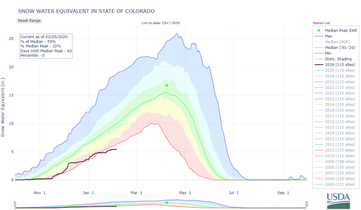
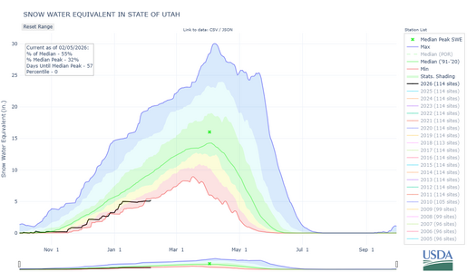
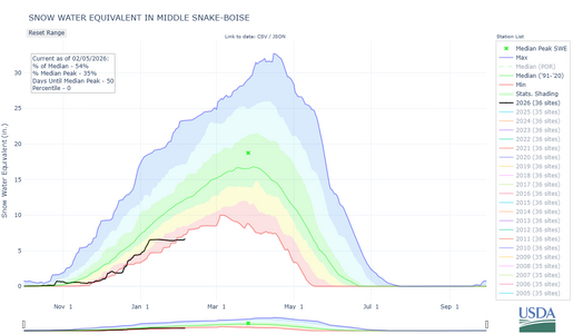
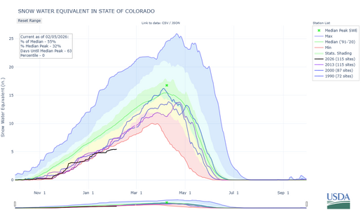
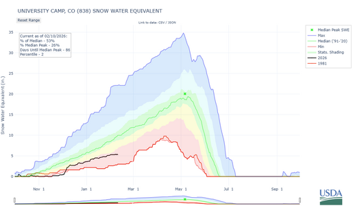
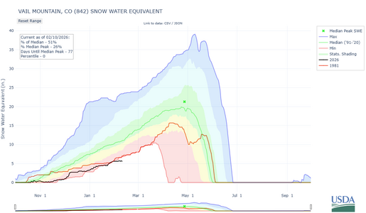
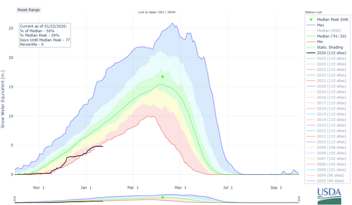
For the following two maps, the upper dark blue line is a composite of the highest SWEs for each day of the winter over the years, and the lower red line is a composite of the lowest SWEs for each day of the winter. The shading corresponds to the percentile categories. Percentile categories range from: minimum to 10th percentile , 10th - 30th , 30th - 70th , 70th - 90th , and 90th - maximum. The green line is the median (1991-2020).
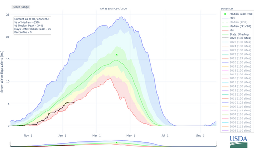
Things are similar in the State of Colorado, with current statewide Snow Water Equivalent conditions being the lowest on record for this date. Records stretch back to 1987.
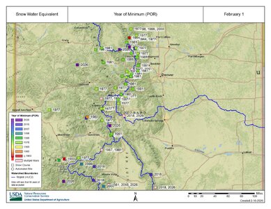
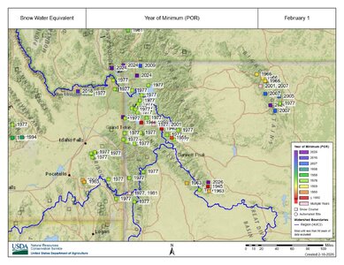
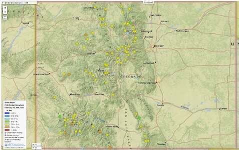
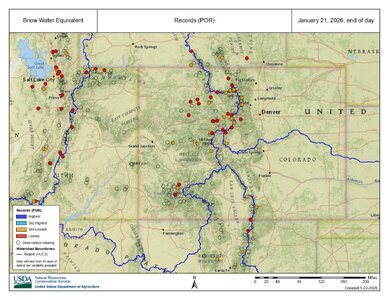
When looking at individual snow monitoring stations, the picture is also very grim, and reveals an interesting pattern between snowpack and elevation. The following map for the Southern Rockies shows stations experiencing their lowest ever SWE in red, and stations experiencing their second lowest SWE in orange. The period of record (POR) stretches back ~45 years at most locations. Many of the locations shown as transparent circles don't have a sufficient body of data to display records, but it's worth noting that many of these newer stations are still experiencing their worst or second worst SWE on record.
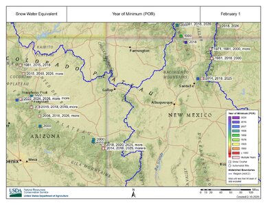
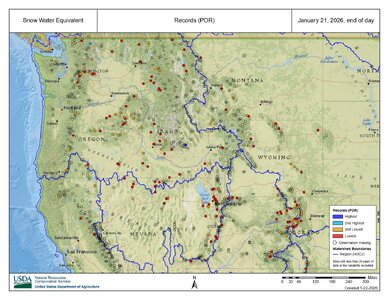
West-wide, many stations are currently experiencing their lowest SWE on record, even in the river basins that have near-normal SWE overall! Many of the stations at lower elevation in Wyoming and Montana have much below normal SWE even though the neighboring higher stations have a normal or above-normal SWE. This seems to be due to temperature, as the lower elevation stations have seen temperatures too warm for snow even though ample precipitation has been falling.
What about snow depth? This is something a skiier would care about much more than SWE. Well, across the Southern Rockies, snow depth conditions are actually WORSE than SWE conditions! It's worth noting that most snow depth observations only have a 25-year history, so years before 2000 generally aren't factored into the following maps.
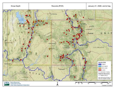
Looking at the West as a whole, snow depth is still generally near its lowest level in the last 25 years across the lower elevations.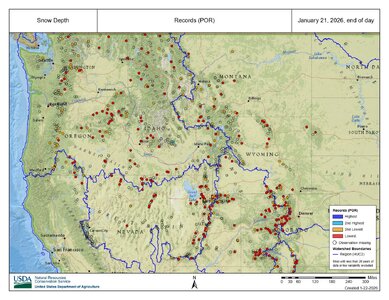
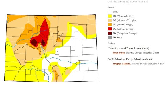
Of course, there's still plenty of time left in the winter, and the West's mountains typically see their greatest snow accumulations in February, March, and April. So theoretically we could see a few huge storms, and the snowpack would return to near-normal levels. However, long-term forecasts aren't looking overly optimistic. If the current trends continue on, we could see serious drought develop this summer across the Southern Rockies, and we could see the potential for a very destructive fire season.
The La Nina pattern this year has been coupled with unusually persistent ridging over the West Coast with only minor exceptions, and it's taken a major toll on snowpack in the Southern Rockies. The cold air outbreaks that have been buffeting the eastern half of the country have also largely missed us here with the exception of the one going on right now.
I'll be mainly examining the period from October to January, as September was reasonably normal here (in the Southern Rockies at least). September 2025 was Denver's first below-average September in 14 years (0.1 degrees below normal-link).
From October to December, persistent ridging over the west produced record warmth for almost every western state. Denver, and many other places, saw the warmest Christmas Day on record. Denver's high on Christmas Day hit 71 degrees, with the previous record being 69 degrees, set in 2005 (link). Mountain towns in Colorado like Vail, Aspen, Steamboat Springs, and many others saw rain on Christmas Day, along with temperatures in the 50s (news article) (data link).
When looking at statewide average temperature from October to December, the stats speak for themselves:
(State temperature/precipitation maps from U.S. Maps | National Centers for Environmental Information (NCEI))

Meanwhile, thanks to a series of robust atmospheric rivers, statewide precipitation across the West was actually at above-normal levels.

But yet, despite ample precipitation, snowpack across the West is still much below normal. I'm using the latest data from today, January 22nd, for the following snowpack images. All of the following images were generated using the NWCC iMap, which is a fantastic tool for monitoring snowpack across the West.
Note: Snow Water Equivalent (SWE) will be the metric used in most of these images unless otherwise mentioned, which for the uninitiated is a measure of how many inches of water would be produced if the snow was melted. This metric is used instead of snow depth because snow density heavily influences how much water content is in the snowpack, and water managers are more concerned about the water than the snow depth. Skiiers would be more concerned about snow depth, and I'll discuss that later.
At the moment, SWE is generally much below the 1991-2020 median across the West's river basins, with the exception of a few basins in Montana, Wyoming, and California.

And yet, at the same time, most of the same river basins have seen normal or above-normal amounts of precipitation.

The natural conclusion from these stats is that the precipitation has been falling as expected, but that temperatures have been too warm for it all to fall as snow. This has potentially drastic implications for the upcoming summer's river levels, especially in the Colorado, Platte, Arkansas, and Rio Grande river basins. Snowpack also has an impact on the summer fire season, and a poor snowpack combined with a warm summer can increase the likelihood of fires. A discussion of the importance of snowpack as opposed to rain can be found at the following links:
A Warmer Spring: How a Changing Snowpack is Altering Colorado’s Environment | Sustainability | Colorado State University
Understanding Snow - Water Education Colorado
SnowTrax - Home
Speaking of the Colorado River, Snow Water Equivalent in the Upper Colorado Basin is currently at its lowest level for January 22nd since records began in 1986.
For the following two maps, the upper dark blue line is a composite of the highest SWEs for each day of the winter over the years, and the lower red line is a composite of the lowest SWEs for each day of the winter. The shading corresponds to the percentile categories. Percentile categories range from: minimum to 10th percentile , 10th - 30th , 30th - 70th , 70th - 90th , and 90th - maximum. The green line is the median (1991-2020).

Things are similar in the State of Colorado, with current statewide Snow Water Equivalent conditions being the lowest on record for this date. Records stretch back to 1987.

When looking at individual snow monitoring stations, the picture is also very grim, and reveals an interesting pattern between snowpack and elevation. The following map for the Southern Rockies shows stations experiencing their lowest ever SWE in red, and stations experiencing their second lowest SWE in orange. The period of record (POR) stretches back ~45 years at most locations. Many of the locations shown as transparent circles don't have a sufficient body of data to display records, but it's worth noting that many of these newer stations are still experiencing their worst or second worst SWE on record.

West-wide, many stations are currently experiencing their lowest SWE on record, even in the river basins that have near-normal SWE overall! Many of the stations at lower elevation in Wyoming and Montana have much below normal SWE even though the neighboring higher stations have a normal or above-normal SWE. This seems to be due to temperature, as the lower elevation stations have seen temperatures too warm for snow even though ample precipitation has been falling.

What about snow depth? This is something a skiier would care about much more than SWE. Well, across the Southern Rockies, snow depth conditions are actually WORSE than SWE conditions! It's worth noting that most snow depth observations only have a 25-year history, so years before 2000 generally aren't factored into the following maps.

Looking at the West as a whole, snow depth is still generally near its lowest level in the last 25 years across the lower elevations.

Of course, there's still plenty of time left in the winter, and the West's mountains typically see their greatest snow accumulations in February, March, and April. So theoretically we could see a few huge storms, and the snowpack would return to near-normal levels. However, long-term forecasts aren't looking overly optimistic. If the current trends continue on, we could see serious drought develop this summer across the Southern Rockies, and we could see the potential for a very destructive fire season.

