Matt Hunt
EF3
My hopes were not that high for this day, after having chased the day before and not seeing much more than junk storms (I had gone north to Douglas, WY, so I missed the action that Tony Laubach saw in the NE panhandle). Saturday was a very similar setup, although it seemed even less favorable, as shear had weakened, and dewpoints had dropped. I was close to just heading back home, but decided since I'd made the drive out, I might as well stay and see what happens.
The day started much like Friday with high-based storms firing off the high terrain by early afternoon. I sat in Cheyenne, WY for a while just watching them. More started to form to the east, and eventually kicked out an outflow boundary that started to drop south. I was happy to see that! At the time, the storm furthest east was looking the strongest, so I headed that way toward Kimball, NE. By the time I was approaching Kimball, that storm was started to die out, but I could see that new development was building along that outflow boundary to the south, so I dropped south on Hwy 71 into the Pawnee National Grassland in northern Colorado. Here the storm started to take on some decent structure.
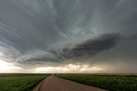
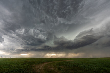
It continued to back build along the boundary, to the south and west. It was still high-based, so I didn't need to be that close to it to see it all, and actually preferred to stay back a little to get the full structure shots. There was some broad rotation, and it went tornado warned, but I didn't ever think it was close to producing. (there ended up being a couple tornado reports which I question, but one was much further north from my position at the time, so I can't speak on the accuracy of that one)
As the storm approached Ft. Morgan, it took on some incredible structure!
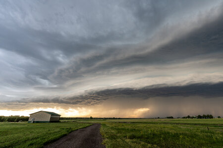
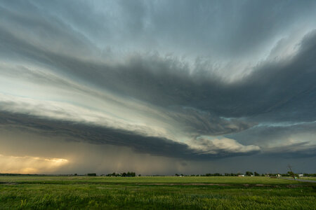
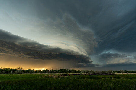
After this image, I tried to reposition to a spot further in front of the storm, but by that time, it was losing its structure.
All in all, I was very happy to get some great structure shots out of this storm. The last several years have been quite unsuccessful for me, where my decision making has been horrible. Finally on this day, I made all the right decisions, and got on the storm of the day. Living in Idaho, it's a very long drive to the southern Plains, but only 9 hours to Cheyenne. I think I'll keep taking my chasecation in June from here on out to chase the northern Plains. I also loved the serious lack of crowds! Even on a Saturday, while there were other chasers out, there weren't very many (granted, it was also a pretty marginal setup).
Unfortunately it was back to work yesterday, so I missed that insanely photogenic tornado in North Platte, NE yesterday. But due to the lack of success in recent years, I only took a one week chasecation this year. This storm may have saved storm chasing as a hobby for me. I believe I'll go back to 2 weeks next year!
The day started much like Friday with high-based storms firing off the high terrain by early afternoon. I sat in Cheyenne, WY for a while just watching them. More started to form to the east, and eventually kicked out an outflow boundary that started to drop south. I was happy to see that! At the time, the storm furthest east was looking the strongest, so I headed that way toward Kimball, NE. By the time I was approaching Kimball, that storm was started to die out, but I could see that new development was building along that outflow boundary to the south, so I dropped south on Hwy 71 into the Pawnee National Grassland in northern Colorado. Here the storm started to take on some decent structure.


It continued to back build along the boundary, to the south and west. It was still high-based, so I didn't need to be that close to it to see it all, and actually preferred to stay back a little to get the full structure shots. There was some broad rotation, and it went tornado warned, but I didn't ever think it was close to producing. (there ended up being a couple tornado reports which I question, but one was much further north from my position at the time, so I can't speak on the accuracy of that one)
As the storm approached Ft. Morgan, it took on some incredible structure!


After this image, I tried to reposition to a spot further in front of the storm, but by that time, it was losing its structure.
All in all, I was very happy to get some great structure shots out of this storm. The last several years have been quite unsuccessful for me, where my decision making has been horrible. Finally on this day, I made all the right decisions, and got on the storm of the day. Living in Idaho, it's a very long drive to the southern Plains, but only 9 hours to Cheyenne. I think I'll keep taking my chasecation in June from here on out to chase the northern Plains. I also loved the serious lack of crowds! Even on a Saturday, while there were other chasers out, there weren't very many (granted, it was also a pretty marginal setup).
Unfortunately it was back to work yesterday, so I missed that insanely photogenic tornado in North Platte, NE yesterday. But due to the lack of success in recent years, I only took a one week chasecation this year. This storm may have saved storm chasing as a hobby for me. I believe I'll go back to 2 weeks next year!
