• While Stormtrack has discontinued its hosting of SpotterNetwork support on the forums, keep in mind that support for SpotterNetwork issues is available by emailing [email protected].

2025-06-08 EVENT: TX/OK

JamesCaruso

Staff member
Joined
Jul 5, 2009
Messages
1,980
Location
Newtown, Pennsylvania
Complicated forecast today in terms of where discrete supercells are most likely to form and remain discrete. Cold fronts are never great initiating boundaries for chasing, and clearly any storms that go up on the front will suffer from storm interference and will congeal quickly. HRRR has been fairly consistent bringing a cell out of the western OK panhandle and moving it southeast into the TX panhandle. This storm goes up on the cold front and in SW surface winds. Not as consistently, but on several runs, the HRRR has shown a supercell that appears to stay discrete longer, with a nice helicity track, beginning a couple counties northwest of Childress.

There's not much convergence along the dryline, with RAP and NAM showing the moisture mixing out southwest of LBB. There's a hint of a dryline bulge so thinking of playing northeast of that, in the southeastern quadrant of the TX panhandle. Hoping for an open warm sector storm in an area of confluence east of the dryline. Models suggest the moisture trajectory feeding into this area, with more backed winds. Issue will be high temps and resulting temp/dewpoint depressions, but going to be tough to avoid that while also taking advantage of the extreme instability.

Currently in Dumas after enjoying a beautiful supercell in northeastern NM last night. Going to head down to AMA to keep options open and re-evaluate from there.

I'm burned out from last week so sitting out today and now back home but I'd be keeping a close eye on the NW-SE oriented boundary from Clayton, NM down towards Amarillo, TX associated with a disturbance proximal to Hereford, TX. Models indicate a bit of moisture pooling into that region later INVO the cells that develop in the western panhandle of OK and track southeast. There is also discrete supercell development as you noted that is progged further south east of the DL although tornado potential here looks more nebulous and some models show this only down near I-20 whereas others have cells further north into the LBB area. On the other hand, there is subsidence in the wake of earlier convection across the northern panhandle and while the atmosphere will recover as you noted the frontal forcing and shear profiles favor rapid consolidation into a QLCS mode here.
 
Thanks Jesse. Will post a Reports thread when I get a chance, but to close the loop here, we ended up targeting the dryline in the southeastern quadrant of the TX panhandle. This choice was at least partly influenced by the need to get to Dallas for flights home today. Hung out at Claude (just SE of AMA on Route 287) and picked up the cell that initiated near AMA. Unfortunately it was immediately in the Caprock Canyon road void bounded by Claude / Silverton / Clarendon / Turkey. A ton of driving all day to navigate this HP beast and only got close to the meso at near 7pm which fortunately was when it went tornado-warned for I think only the second or third time.
 
cell...it was immediately in the Caprock Canyon road void bounded by Claude / Silverton / Clarendon / Turkey. A ton of driving all day to navigate this HP beast...
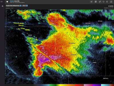
Screenshot 2025-06-08 at 4.34.55 PM.jpg
I was not out chasing, James, but about 15 minutes before this scan, this storm dropped 4 & 1/4 inch hail 10 miles S of Claude at 2116 Z.
Armchair chasers got to see a lot of beautiful structure from chasers' photos and videos of this cell as it made its way relentlessly southeast.
 
As I look at that picture it’s apparent in hindsight that I might have been better off going south from Claude to Silverton, instead of east to Clarendon, but at the time we had to make the call it just seemed like Silverton was way too far south to go before being able to go east again.

EDIT: Just looked back at photos to determine that we were in Claude about an hour before that radar image. At that point, early in the storm’s maturation, I think it was a flip of the coin whether to go east to Clarendon and then south, or south to Silverton and then east. No good options when roads are that far apart.
 
Last edited:
Back
Top