Hannah.Taylor
EF5
Bear with me here guys. This is my first forecast attempt in many years. This might be a bit ugly to some of you. 
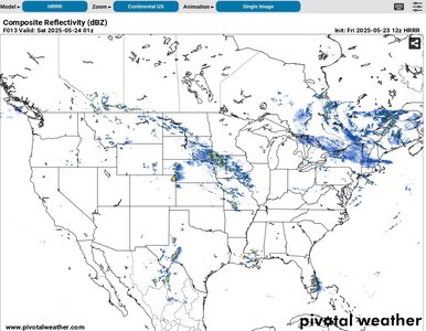
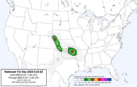
Looking at the GFS and NAM, the moisture is coming in strong in NE CO, SW NE and NW KS. Dews in the near 60º range with temps in the upper 70's to low 80's should give way to discrete and potentially photogenic supercells. 2000 j/kg of CAPE and ample shear at 40kts. The SPC has added in 2% tornado hatched area (Nadocast has NE CO in a 5% tornado hatched area) from the CO/NE Panhandle state line down to the panhandle of OK. Steep lapse rates and more than sufficient lift should help storms get going. The HRRR spits out a supercell right between Sterling and Julesburg at 13z.
Initial target will be somewhere in a triangle between Sterling, Julesburg and Wray but I'll have to re-check the dewpoint map closer to initiation between 21z and 23z and I may adjust my target accordingly to put myself in the best area for Moisture, CAPE, Shear an Lift.
While not an ideal setup, there at least appears to be multiple chase opportunities over the next few days in CO/KS/OK and TX and that sure beats what I was seeing earlier in the week and last weekend. So I'll be taking a crack at some forecasts over the next few days as well. (Please feel free to DM constructive critique and corrections.)
Looking at the GFS and NAM, the moisture is coming in strong in NE CO, SW NE and NW KS. Dews in the near 60º range with temps in the upper 70's to low 80's should give way to discrete and potentially photogenic supercells. 2000 j/kg of CAPE and ample shear at 40kts. The SPC has added in 2% tornado hatched area (Nadocast has NE CO in a 5% tornado hatched area) from the CO/NE Panhandle state line down to the panhandle of OK. Steep lapse rates and more than sufficient lift should help storms get going. The HRRR spits out a supercell right between Sterling and Julesburg at 13z.


Initial target will be somewhere in a triangle between Sterling, Julesburg and Wray but I'll have to re-check the dewpoint map closer to initiation between 21z and 23z and I may adjust my target accordingly to put myself in the best area for Moisture, CAPE, Shear an Lift.
While not an ideal setup, there at least appears to be multiple chase opportunities over the next few days in CO/KS/OK and TX and that sure beats what I was seeing earlier in the week and last weekend. So I'll be taking a crack at some forecasts over the next few days as well. (Please feel free to DM constructive critique and corrections.)
Last edited:

