Dan Robinson
EF5
First, my tale of woe. I started at home, awaiting confirmation that St. Louis would indeed be in the clear before heading east/south to the most favored area for tornadoes in southern Illinois. The dewpoint at Lambert Airport was 52F at 1pm, and although a supercell was organizing and entering the western metro, I thought that there was no way it would be able to do much. Additionally, the storm was initially tracking northeast and it appeared it would miss the city altogether.
When the storm produced a big RFD surge near Chesterfield, I started heading into downtown just in case it had visible structure over the city. I made it to O'fallon, 15 miles out, when the RFD surge appeared it would be a HP mess. Also about that time, the storm resumed a northeasterly motion on the next couple of radar scans. It appeared to be on course to move harmlessly off to the north (aside from hail). Another rapidly organizing storm was just to my south and heading for an I-64 crossing to my east, so I turned around and began heading that way.
About 10 miles later, I saw the south end of the RFD surge of the STL supercell was relaxing and developing a strong convergence signal - right over I-64, due west of downtown. It was obvious what was about to happen, and I frantically exited at the first opportunity and headed back west. It was too late.
I've posted before about how many tornadoes and great storms I've missed (in both the Plains and the Midwest) due to my home target bias - a bias I practiced with fervor specifically to prevent me from missing events like today. And I still missed it. Why? Because STL storms often do these fake-outs and last-minute about-faces that seem designed to make a chaser miss them. Or maybe I'm just a horrible forecaster and chaser. It's probably the latter, but it sure does feel like St. Louis storms don't like giving you much of a heads up when they're about to do something noteworthy.
Strangely enough, I'm not even mad. I'm more just laughing, partly at the exposure that I have no idea what I'm doing plus the irony of it all. I *predicted* this would happen (even posting as much in an ST thread last year).
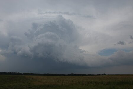
Anyway. I ended up on a storm at Irvington that slowly shriveled as I kept pace with it to Salem. I gave up on it there and dropped back south to Mount Vernon to regroup. There were no good options within 70 miles, and I was ready to just give up and go home. As I pondered the calamity of the day, I realized a new supercell down near Sikeston was within striking distance at Marion, so I thought I'd go keep it honest. I expected it to die right as i arrived on it, as instability was dropping off to its east on mesoanalysis. Plus, a lot of days like this tend to not get better as they go.
I arrived in Marion to see the storm organizing rapidly, with an RFD surge focusing a circulation to the southwest as the entire storm began a hard right turn. A few larger hailstones began crashing onto Highway 13, and I felt I risked getting cored staying at that latitude. I dropped south on North Refuge Road and managed to get a close-up of the tornado developing and crossing the road.
There was no way to keep up with this, so I headed down to Paducah for the next supercell in the line. The cold front caught up to it and killed it before it arrived, ending my chase.
So, I didn't bust, but I failed in my 14-year quest to not miss a historic/significant tornado in St. Louis visible behind the skyline. Will I keep my home target bias after it's not only cost me so much, but ended up failing anyway? Who knows. I know it will be 60-70 years before something like that happens again, if history is any indication. It's the first time a tornado was visible behind the Arch since it was built 62 years ago, anyway. Likely not in my lifetime. The silver lining is that it wasn't a Lincoln, Nebraska 4/26, but a rather poor-contrast non-photogenic one, at least from the typical skyline angles.
When the storm produced a big RFD surge near Chesterfield, I started heading into downtown just in case it had visible structure over the city. I made it to O'fallon, 15 miles out, when the RFD surge appeared it would be a HP mess. Also about that time, the storm resumed a northeasterly motion on the next couple of radar scans. It appeared to be on course to move harmlessly off to the north (aside from hail). Another rapidly organizing storm was just to my south and heading for an I-64 crossing to my east, so I turned around and began heading that way.
About 10 miles later, I saw the south end of the RFD surge of the STL supercell was relaxing and developing a strong convergence signal - right over I-64, due west of downtown. It was obvious what was about to happen, and I frantically exited at the first opportunity and headed back west. It was too late.
I've posted before about how many tornadoes and great storms I've missed (in both the Plains and the Midwest) due to my home target bias - a bias I practiced with fervor specifically to prevent me from missing events like today. And I still missed it. Why? Because STL storms often do these fake-outs and last-minute about-faces that seem designed to make a chaser miss them. Or maybe I'm just a horrible forecaster and chaser. It's probably the latter, but it sure does feel like St. Louis storms don't like giving you much of a heads up when they're about to do something noteworthy.
Strangely enough, I'm not even mad. I'm more just laughing, partly at the exposure that I have no idea what I'm doing plus the irony of it all. I *predicted* this would happen (even posting as much in an ST thread last year).
Anyway. I ended up on a storm at Irvington that slowly shriveled as I kept pace with it to Salem. I gave up on it there and dropped back south to Mount Vernon to regroup. There were no good options within 70 miles, and I was ready to just give up and go home. As I pondered the calamity of the day, I realized a new supercell down near Sikeston was within striking distance at Marion, so I thought I'd go keep it honest. I expected it to die right as i arrived on it, as instability was dropping off to its east on mesoanalysis. Plus, a lot of days like this tend to not get better as they go.
I arrived in Marion to see the storm organizing rapidly, with an RFD surge focusing a circulation to the southwest as the entire storm began a hard right turn. A few larger hailstones began crashing onto Highway 13, and I felt I risked getting cored staying at that latitude. I dropped south on North Refuge Road and managed to get a close-up of the tornado developing and crossing the road.
There was no way to keep up with this, so I headed down to Paducah for the next supercell in the line. The cold front caught up to it and killed it before it arrived, ending my chase.
So, I didn't bust, but I failed in my 14-year quest to not miss a historic/significant tornado in St. Louis visible behind the skyline. Will I keep my home target bias after it's not only cost me so much, but ended up failing anyway? Who knows. I know it will be 60-70 years before something like that happens again, if history is any indication. It's the first time a tornado was visible behind the Arch since it was built 62 years ago, anyway. Likely not in my lifetime. The silver lining is that it wasn't a Lincoln, Nebraska 4/26, but a rather poor-contrast non-photogenic one, at least from the typical skyline angles.
Last edited: