Jeremy Perez
Supporter
This was an extremely enjoyable chase with slow moving storms in central Texas. I was initially planning to drive home this day, but a possibility of extreme instability and a tempting outflow boundary convinced me to hang around. Interestingly, I wound up targeting near where we tried to watch the solar eclipse the previous year. Storms fired earlier than I was anticipating and I needed to pass through the fringes of some hail to get to the east side of the convection near Killeen. Trees are a challenge here, but I finally found an okay vantage south of Oakalla to watch the south moving cell strengthen and soon receive a tornado warning.
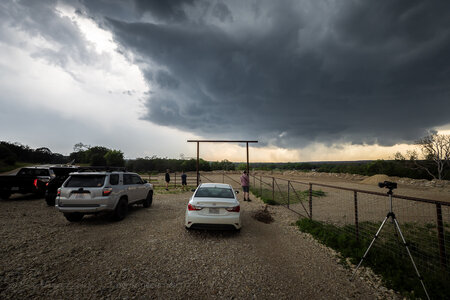
Strengthening storm from east of Oakalla, Texas as it picks up a tornado warning — 2114Z.
It was moving very slowly, but I eventually had to move to stay out of the forward flank and maintain visibility. I ran across a hilltop vantage further to the west, closer to the hook. The RFD occlusion was well developed and things looked really promising. The mist of rear flank precipitation was light enough that the descending mass wrapped in the middle was discernible as it tightened up and formed a rugged stovepipe. One visual concern was an unfortunately placed power pole, which I have removed in the three photos immediately below, to better appreciate the storm's structure.
As it started taking shape, I realized I wanted a video height advantage and made my first attempt at attaching the super clamp to my roof luggage rack and that actually worked pretty well.
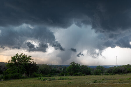
Inverted Hershey’s kiss, trying to be a drill bit — 2137Z.
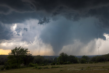
Fully condensing — 2142Z.
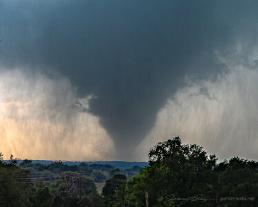
Zoomed in — 2143Z.
After 20 minutes in that spot, a handoff circulation looked like it was forming overhead, so I headed off to the south and watched the last few minutes of the tornado roping out while that new circulation lunged to the southwest.
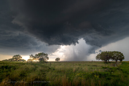
Occluded stovepipe getting ready to rope out — 2147Z.
The tornado finally dissipated after 20 minutes and I headed further south to get in good position on the next circulation approaching Briggs.
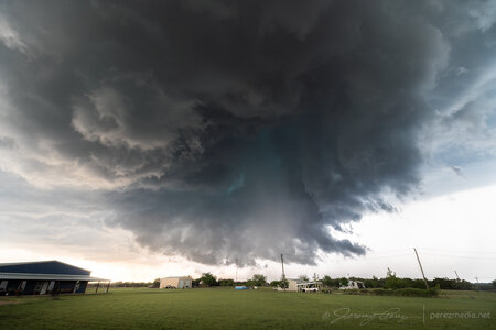
New RFD cut puckering up the base north of briggs — 2159Z.
It was a treat finding a better spot to watch this cycle from closer in and see all the churning detail in the base surrounding and beneath the RFD. Once it occluded, a smooth bowl lowering took shape and gradually started to narrow.
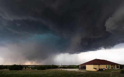
Funnel taking on a point and time to reposition again — 2213Z.
Realizing the risk in missing something, I still needed to reposition and headed west where Loop 308 intersects Highway 183. I rounded that corner just in time to see another massive, tilted stovepipe aimed at the highway to the north. Traffic mostly slowed down and chasers pulled over so I had easy access to the middle of the road for photos as it churned just a couple miles to the northwest. What a sight! Just towering up into the turquoise core—so glad I didn’t start my drive home this day.
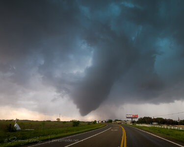
Turning onto Highway 183 from Loop 308 just in time to catch this — 2218Z.
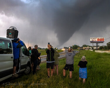
Tour group getting their money’s worth — 2220Z.
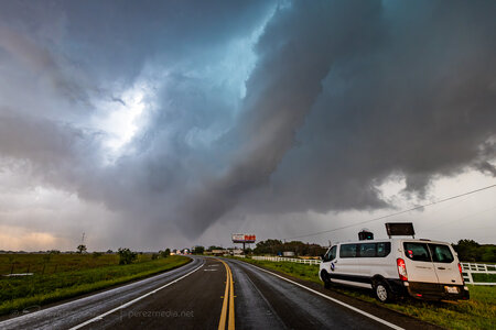
2220Z.
I only had three minutes with it before a blob of rain moved in and washed out the view. On the drive south, six minutes later (2226Z), the funnel re-emerged from the rain and bobbed around for a bit before dissipating. Another 15 minutes later (2242Z), another funnel emerged. I’m not sure if it was a continuation of the second tornado or something new or if it even touched down. Nothing shows up from it on the NWS Damage Assessment Toolkit.
What an awesome chase day and a great way to wrap up an early 2026 Plains chase season!
Full report and photos can be found here: 1 May 2025 | Briggs, Texas, USA | Tornadoes

Strengthening storm from east of Oakalla, Texas as it picks up a tornado warning — 2114Z.
It was moving very slowly, but I eventually had to move to stay out of the forward flank and maintain visibility. I ran across a hilltop vantage further to the west, closer to the hook. The RFD occlusion was well developed and things looked really promising. The mist of rear flank precipitation was light enough that the descending mass wrapped in the middle was discernible as it tightened up and formed a rugged stovepipe. One visual concern was an unfortunately placed power pole, which I have removed in the three photos immediately below, to better appreciate the storm's structure.
As it started taking shape, I realized I wanted a video height advantage and made my first attempt at attaching the super clamp to my roof luggage rack and that actually worked pretty well.

Inverted Hershey’s kiss, trying to be a drill bit — 2137Z.

Fully condensing — 2142Z.

Zoomed in — 2143Z.
After 20 minutes in that spot, a handoff circulation looked like it was forming overhead, so I headed off to the south and watched the last few minutes of the tornado roping out while that new circulation lunged to the southwest.

Occluded stovepipe getting ready to rope out — 2147Z.
The tornado finally dissipated after 20 minutes and I headed further south to get in good position on the next circulation approaching Briggs.

New RFD cut puckering up the base north of briggs — 2159Z.
It was a treat finding a better spot to watch this cycle from closer in and see all the churning detail in the base surrounding and beneath the RFD. Once it occluded, a smooth bowl lowering took shape and gradually started to narrow.

Funnel taking on a point and time to reposition again — 2213Z.
Realizing the risk in missing something, I still needed to reposition and headed west where Loop 308 intersects Highway 183. I rounded that corner just in time to see another massive, tilted stovepipe aimed at the highway to the north. Traffic mostly slowed down and chasers pulled over so I had easy access to the middle of the road for photos as it churned just a couple miles to the northwest. What a sight! Just towering up into the turquoise core—so glad I didn’t start my drive home this day.

Turning onto Highway 183 from Loop 308 just in time to catch this — 2218Z.

Tour group getting their money’s worth — 2220Z.

2220Z.
I only had three minutes with it before a blob of rain moved in and washed out the view. On the drive south, six minutes later (2226Z), the funnel re-emerged from the rain and bobbed around for a bit before dissipating. Another 15 minutes later (2242Z), another funnel emerged. I’m not sure if it was a continuation of the second tornado or something new or if it even touched down. Nothing shows up from it on the NWS Damage Assessment Toolkit.
What an awesome chase day and a great way to wrap up an early 2026 Plains chase season!
Full report and photos can be found here: 1 May 2025 | Briggs, Texas, USA | Tornadoes
