• While Stormtrack has discontinued its hosting of SpotterNetwork support on the forums, keep in mind that support for SpotterNetwork issues is available by emailing [email protected].

2025-04-28 EVENT: IA/KS/OK/MO/NE/MN/WI/IL

I hear you, but you will have a much better understanding of the granular details of a forecast if you look at the models yourself and then gets SPC’s take after you develop your own.

Also, SPC outlooks are designed for public safety, not designed for chasers. Monday’s event will definitely be a public safety risk. Whether it is chase-worthy is a different question that may not be adequately answered by their forecasts.
Agreed. I start looking at 48 hours for my own take, especially with a chase in mind. As for SPC, I tend to pay more attention to certain forecasters who I know are also chasers like Roger Edwards and Rich Thompson. Roger in particular tends to write very insightful outlooks.
 
Agreed. I start looking at 48 hours for my own take, especially with a chase in mind. As for SPC, I tend to pay more attention to certain forecasters who I know are also chasers like Roger Edwards and Rich Thompson. Roger in particular tends to write very insightful outlooks.

Agreed, but unfortunately for us Roger recently retired (sorry for OT post)
 
I spent way too much time yesterday trying to get a handle on the forecast. By the time I went to bed, I realized that we're going to see more activity across the moderate risk than what a computer model says. The windspeed of the jet max, trough, and other parameters provide plenty for severe convection before dark. This powerful setup could be chased in north-central Iowa. Start perhaps in Storm Lake, Iowa. ;)
 
When I was typing up the original post I had noted to myself that global models showed convection along much of teh dryline, even into west Texas, while the barely in-range NAM12k was showing basically nothing south of northern Iowa. So I'm not surprised to see the now in-range CAMs not overly enthusiastic with blowing up dryline convection. My understanding has been that the CAMs often struggle with dryline initiation. The SPC in today's day 2 has essentially addressed this, saying the CAM guidance "does not seem realistic considering the overall pattern."

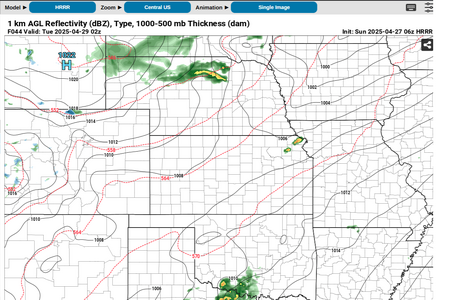
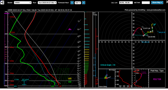
That said, the 06Z HRRR shows some nighttime storms in NE Kansas in a favorable environment. It will be interesting to see how they handle this setup as it draws closer.

04 29 2025 02Z HRRR 06Z 04272025.png04 29 2025 02Z eastern KS.png
 

Attachments

  • 04 29 2025 02Z eastern KS.png
    04 29 2025 02Z eastern KS.png
    190.2 KB · Views: 14
The 13Z outlook from SPC does in fact back off the probabilities south of I-80 compared to what their outlook and discussion implied yesterday. NADOCAST backs off even more.

There has been, however, an interesting model depiction of a supercell to the west and NW of MKC yesterday and today. I suppose a mesoscale tornado watch could be issued from 40 either side of a line from 25 NE of KMCI to 40 mi SW of Lawrence.

1:30pm comment: They backed off further at 1730Z both on the tornado probabilities and in the wording ("more conditional threat") of the discussion in multiple places.
 
Last edited:
Not confident anything will happen at this point. MDT risk seems conditional at best. After reviewing morning NAM and CAMs and the 18z HRRR, it seems doubtful convection will fire before dark in NE IA. OTOH, it's only a three hour drive for me so plenty of time to react if the situation changes.
 
CAMs are now in broad agreement on timing and location of initiation:

Around 22z in western/northern Iowa, as well as SW Oklahoma and adjacent Texas areas into central OK.

A later initiation around 00z-02z in northeast KS / northwest MO into southern Iowa (although NAM thinks the cap won't be broken until several hours later).

Previously there was forecast discussion about a squall line on the cold front. They must have meant up in MN near the surface low because models have been consistent with the cold front largely trailing the dryline, with temperatures expected to rise as the dryline passes through IA, and especially KS and OK. With storm vectors approximately perpendicular to the dryline, this is nearly textbook for discrete supercell initiation.

Current observations show the entirety of Iowa blanketed with cloud cover with clearing skies down in SW Oklahoma. Dewpoints are expected to be in the upper 60s near 70F all along the leading edge of the dryline. Altus OK is currently reporting a 67F dewpoint, with mid-60s DPs extending all the way to Sioux Falls and the WF. Forecast hodos still show surface winds struggling to fully back from the S or SSE in Iowa, although this is less of an issue further south in the secondary (tertiary?) target.

If I were chasing, I would focus on the southern target in OK due to clear skies, better DPs and instability, surface wind backing / LLJ, and more consistent model signal, although the northern Iowa target is tempting as well.
 
All three targets (MN/IA, SW OK, NE KS) appeared solid this morning and still seem to be retaining their merits. The northern one looks more favored due to better upper support and a broader warm sector with the best shear/instability combo of the three. I opted for Kansas for the convenience factor in being 4 hours from home at the end of the day, but the environment here will be volatile itself within the next couple of hours.
 
From the onset of the first storms to fire around 1350 CDT, I was worried about this being a linear event, which it ended up being.

Storms never managed to stay discrete. Three tornado warned storms and no confirmed tornadoes on the ground. Very disappointing.
 
Incredible bust, even if some additional small tornadoes are found. As of Noon Tuesday.
 

Attachments

  • Screenshot 2025-04-29 at 12.39.13 PM.png
    Screenshot 2025-04-29 at 12.39.13 PM.png
    293.4 KB · Views: 12
I will add this: this was my first out-of-state chase in five years. At first, I bought the SPC outlooks. Then I started detailed forecasting at 48 hours and began to wonder: what are they seeing? I don't see a MDT Risk. At 24 and 12 hours, the models mostly settled on one solution (for the target area): a line of storms crossing southern MN. The models did well. The forecasters? Not so much. I don't know why. I'm sure they're wondering that too. The moral? The atmosphere can and will surprise. Forecasters are human. Ce le vie.
 
Back
Top