• After witnessing the continued decrease of involvement in the SpotterNetwork staff in serving SN members with troubleshooting issues recently, I have unilaterally decided to terminate the relationship between SpotterNetwork's support and Stormtrack. I have witnessed multiple users unable to receive support weeks after initiating help threads on the forum. I find this lack of response from SpotterNetwork officials disappointing and a failure to hold up their end of the agreement that was made years ago, before I took over management of this site. In my opinion, having Stormtrack users sit and wait for so long to receive help on SpotterNetwork issues on the Stormtrack forums reflects poorly not only on SpotterNetwork, but on Stormtrack and (by association) me as well. Since the issue has not been satisfactorily addressed, I no longer wish for the Stormtrack forum to be associated with SpotterNetwork.

    I apologize to those who continue to have issues with the service and continue to see their issues left unaddressed. Please understand that the connection between ST and SN was put in place long before I had any say over it. But now that I am the "captain of this ship," it is within my right (nay, duty) to make adjustments as I see necessary. Ending this relationship is such an adjustment.

    For those who continue to need help, I recommend navigating a web browswer to SpotterNetwork's About page, and seeking the individuals listed on that page for all further inquiries about SpotterNetwork.

    From this moment forward, the SpotterNetwork sub-forum has been hidden/deleted and there will be no assurance that any SpotterNetwork issues brought up in any of Stormtrack's other sub-forums will be addressed. Do not rely on Stormtrack for help with SpotterNetwork issues.

    Sincerely, Jeff D.

2025-04-28 EVENT: IA/KS/OK/MO/NE/MN/WI/IL

Patrick K

EF0
Joined
May 2, 2019
Messages
40
Location
Southeast USA
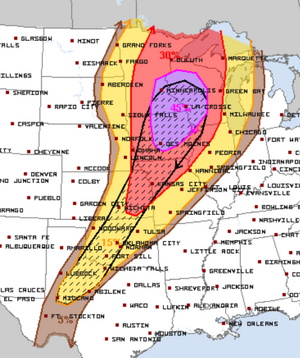
A positively-tilted mid-level trough will eject from the Rockies on Sunday and move toward the upper midwest by Monday evening. As a result, mid 60s DPs will already be in place in terms of northward extent on Sunday. On Monday, a sharpening dryline will extend southward from the associated surface low through extreme southeastern Nebraska, eastern Kansas, and into central Oklahoma. Significant capping will exist over much of the area during the day until a shortwave trough begins impinging on the warm sector over the Iowa area by the afternoon. CAMs are not yet in range, but there will not be a sharp cold front until Tuesday, so the capping and more subtle forcing from the shortwave and dryline should result in widely spaced supercells, and storm motion will be closer to perpendicular to the dryline than parallel.

Current forecasts have surface winds struggling to back from the S or SSE, at least initially over the main target - but SRH should in theory be enough to get it done. It seems possible that cloud cover could limit instability and prevent storm initiation until much later, but the potential target area is large enough that it seems likely storms will fire somewhere. Currently it looks like the best chance of storms will be in IA, where mid 60s DPs will sit directly underneath the strongest portion of the jet streak. Another potential target will exist in eastern KS and northwest MO, through north central OK where upper 60s DPs will result in more extreme instability and where some models hint at better surface wind backing. Given the location and setup, this will likely be a busy chase day and fortunately the target area right now looks fairly broad. Stay safe out there everyone!
 
Not studying this event too closely because I can’t be there anyway, and because of that I am admittedly looking to pacify myself with things that could go wrong with this setup… But I’m really not liking the hodographs with this event… Plenty of speed shear but not much directional shear… Pattern recognition suggests messy modes and storms will be racing. I don’t mind sitting this one out. If I were already out there, I’d be more likely to take my chances further south along the dryline, but that has its own problems, with flow parallel to the boundary and bad terrain.

Of course, I said the same thing on May 21, 2024, and was wrong then, so could be wrong now too…
 
SPC is calling for a "tornado outbreak" with the potential for "strong to intense tornadoes" but I'm not quite seeing it as of now.

Surface pressures are not particularly impressive. the 06Z models backed off from the extreme instability at midday shown on the 00Z versions, the dry line contrast is not especially strong, south of I-80 warm sector winds are veered, et cetera. Even SPC is calling for a squall line rather than discrete supercells. SPC also calls for supercells by "midday" but the new 12Z 3km NAM has no initiation until 21Z and that is a couple of weak cells near (where else?) OMA. None of the forecast soundings for 22Z I looked at had anything more than "marginal tor."

I'm sure I am missing something, but I'm not seeing this one.
 

Attachments

  • Screenshot 2025-04-26 at 9.14.34 AM.png
    Screenshot 2025-04-26 at 9.14.34 AM.png
    559.6 KB · Views: 2
They are calling for a squall line ahead the cold front, but the exact wording of the outlook...

"Farther south and east, a more discrete mode will be favored within a weakly capped warm sector."

...suggests they are thinking discrete supercells will erupt in the warm sector to the east and that is the play for me if everything comes to pass.
 
I'm not seeing it with this one. It's got just about everything I hate with a dynamic system. Extremely positively tilted trough, seemingly early/mis-timed trough ejection, relatively linear hodo, weak storm-relative 2-4km winds, shear vectors nearly parallel to boundary, narrow stronger instability axis, and fast storm motions.

That being said, I'll still probably be out somewhere trying to find a diamond in a coal mine but I'm not driving to MN or NE IA for this one.
 
Even SPC is calling for a squall line rather than discrete supercells. SPC also calls for supercells by "midday" but the new 12Z 3km NAM has no initiation until 21Z and that is a couple of weak cells near (where else?) OMA. None of the forecast soundings for 22Z I looked at had anything more than "marginal tor."
I think I agree with you, but that's if the NAM's solution is to be trusted. To me the NAM seems like an outlier compared to the GFS, RAP (out to 18z on monday) and Euro, where the NAM has a "banana low", is far more progressive with dryline / cold front placement, and displaces the LLJ farther east into poor terrain. The other three models have better boundary orientation and are much more aggressive with LLJ placement and intensity. Only time will tell what we will eventually converge to, however.

I'm interested to hear thoughts on common model biases for this region, this time of year, this type of setup, etc.
 
Just a comment: I want to make sure everyone is aware the current (1930Z ) Day 3 is the equivalent of a "high" risk.

The highest an SPC forecaster is allowed to go on Day 3 is the current forecast -- 45% hatched. While this is an aggregate probability, it is still at the top of the scale.

I still believe the current outlook is an over-forecast. The 18Z 3km NAM is very unimpressive. The KMCW sounding storm type at 21Z is "none" and the best I can find between I-80 and I-70 is "marginal tor."

I do believe there will be severe thunderstorms with tornadoes but I think they may have to back off the very high numbers.
 

Attachments

  • Screenshot 2025-04-26 at 4.16.33 PM.png
    Screenshot 2025-04-26 at 4.16.33 PM.png
    641.9 KB · Views: 0
NWS Twin Cities, MN is name-dropping the year 2011 this afternoon.
**DAY 3 MODERATE RISK...THE FIRST SUCH OCCURRENCE ACROSS THE NWS TWIN CITIES FORECAST AREA SINCE APRIL 8, 2011**
And they're taking their threat seriously, for what it's worth.
"The issuance...across SE MN/western WI captures the rare & dangerous nature of the expected setup for severe...capable of...all hazards."
Like many of you, I'm still looking into this to see if flies will "exit the ointment."
 
Back
Top