2024-06-01 REPORTS: CO/KS/NE/SD/NM/TX

John Farley

Supporter
Joined
Apr 1, 2004
Messages
1,824
Location
Pagosa Springs, CO
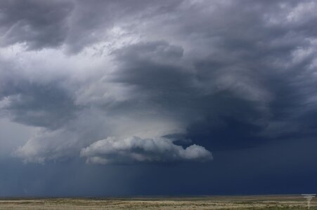
After being tied up with a home improvement project that kept me from chasing on May 30, I decided to head out to the high plains of northeast NM and southeast CO for a couple days. June 1 turned out to be the more interesting, with a slow-moving supercell northwest of Springfield, CO that moved very little due to repeated backbuilding between 2 and 5 p.m. It got 4 SVR warnings and a FFW warning, and for a short time produced rotating rain curtains. Around that time, the SVR warning was upgraded to include a "tornado possible" tag. After that, though, it weakened before cycling one last time. Here are a few pictures:

chase60124-1.jpg

chase60124-4.jpg

chase60124-7.jpg

Shortly after I got to my hotel in Lamar after calling it a chase, a collapsing storm moving in from the west produced some strong, gusty wind, blowing things around in the parking lot.

chase60124-8.jpg

A full report, with more pictures and video from both storms, can be found on my Web pages at:

 
Left home at about 1pm for a target area of northeastern Colorado, specifically an area spanning northwest and southeast around Sterling and Brush, CO where it looked like there could be a narrow window of time where conditions were favorable enough to maybe get a tornado. Got to Brush and noticed a reasonably healthy looking storm near Kimball, NE so I decided to head north from Brush to watch and see if it would get its act together. It looked alright for a while, but a cluster of storms began to develop in that area which resulted in things becoming disorganized and messy in the area. I decided to head southeast to Atwood, CO to get ahead of it and give that area some time to reorganize.

A little while later, and most of the weaker convection had either merged or died off and there was now a stout supercell that was pretty much unimpeded. As it was approaching Sterling, CO it made a right turn and was quickly organizing with an obvious wall cloud and inflow features. At this point I found a nice place where I could stop to film and take photos. The base appeared generally healthy with fairly robust rotation, especially as the RFD began to surge around the southern periphery of the overall circulation. There was a persistent, though somewhat shallow broad bowl-shaped lowering and a few shorter lived small funnels during this time.

TornadoAttempt Downsized.JPG
TinyFunnel Downsized.JPG

The storm gave a solid attempt during that time period, but soon became more messy and disjointed. I moved further southeast along CO-63 to get ahead of the storm in case it was able to successfully cycle and reorganize. It did manage to somewhat briefly reorganize, and had some very interesting structure when it was between CO-63 and CO-61. Found a nice place to stop and take some photos during this timeframe.

Structure Downsized.JPG

Structure3 Downsized.JPG
Structure2 Downsized.JPG

as it proceeded further southeast, visual observations and radar scans showed the storm to be weakening. I didn't feel that it had much tornado potential so I watched the storm move off for another 20 minutes or so before calling the chase and heading back home for the day.
 

Attachments

  • Structure2 Downsized.JPG
    Structure2 Downsized.JPG
    66.5 KB · Views: 0
On June 1st I targeted northeastern Colorado with for some supercell potential. I rode along with some more experienced chasers. I don't have anything to add meteorologically so I'll keep it pretty brief.
After an early cell near the Nebraska border started to weaken and other cells popped up our south, we moved southeastwards towards Sterling in order to stay out of any hail. As we drove towards Sterling, multiple cells to our west and north joined into a larger supercell. Positioned southeast of Sterling we witnessed it produce a nice wall cloud with rapid rotation, which it was never really able to turn into a tornado. The wall cloud and surrounding area became wrapped in rain, so we headed south and caught some nice structure right before the storm promptly disintegrated.

Wall cloud at about 5:20
06-01-2024A.jpg

Wall cloud becoming wrapped in rain, we decided to head south
06-01-2024B.jpg
06-01-2024C.jpg

Storm structure after wall cloud becomes entirely rain wrapped, 5:45
06-01-2024D.jpg
06-01-2024E.jpg

At this time, the storm was rapidly dying and losing its surface-based characteristics. The lowering at the center of the image was cut off from the rest of the storm and eventually dissipated. Roughly 6:00.
06-01-2024F.jpg

After the last photo, the storm became high-based and continued eastward. The chase was over and I headed back home.
 
Back
Top