2024-05-21 EVENT: IA/IL/MO/KS/OK/AR

I ended up in Weatherford, OK after Sunday's great chase. I skipped yesterday in CO as it was just too far, would put me out of position for the rest of my Chasecation. My May and early June has turned into and obstacle course of commitments (including 3 weddings), so am only able to be out until Thu. I am going to give SW Mo a try today, hoping for the possibility of more discrete cells and slower storm motions. It isnt the most ideal chase terrain, especially with S and E extent. But I chase for photography and to appreciate the beauty of nature and less to get as close to the tornado as possible. Then that puts me into position to try my luck in N TX on Wed.
 
As usual, I'm not optimistic about today. Despite any and all pros this setup has, supercells firing right on a plowing cold front does not seem like a good chase to me. I am in Lincoln and am more or less committed to the I-80 cell hop, but eyeing the Missouri play only to be closer to home at the end of the day. The CAMs are hinting at a couple of prefrontal storms in MO which would seem better to me than anything. If the initial storms are undercut, I'll likely bail south if not on the entire chase.
 
Last edited:
Is it just me, or is the SPC forecast, with a 15%-10% hatched area extending well into Illinois, overly bullish? Usually those TOR probabilities spell "major outbreak of strong tornadoes" but the consensus here and elsewhere seems to be that this thing will go linear fairly quickly and that the tornado potential is limited to a smaller area.
 
Storms quickly intensifying near Hastings. I'm not down on this setup. The 300mb winds slam into northern Missouri I-35 corridor later. There's an E/W boundary laying right along the IA/MO border now and appears to have stalled or stalling right now.

RAP soundings look pretty decent, although not as good as the 21Z run I looked at yesterday. If this doesn't just continue blowing up in to a line, we may have some photogenic tubes today
 
It will be in my backyard tonight after sunset, so definitely gonna be out. Thinking Rockford to Galena area roughly.... although a few friends have stated don't rule out crook county yet...
 
A couple items of local knowledge, since I grew up in Waterloo. First, as Andy said, terrain north of US 20 is good west of Waterloo, but once you get east of there, much of the area north of 20 is hilly and wooded, as is much of far northeast Iowa. On the upside, you do not have to be on I-80 to easily move east and west; US 20 is a limited-access freeway most of the way across Iowa, so you can move east and west on it just as easily as on 80, and probably with less traffic. If you are going for the northern part of the arc of storms as Dan mentioned, 20 could be a good option.
 
Can anyone think of a significant outbreak that happened with storms right on a surging cold front? I can't. So my current plan is to focus on storms ahead of the front. CAMs seem to want to fire a few of those along the MO/IA border. I'm in Glenwood, IA southeast of Omaha and about to get a visual on a the first storm ahead of the front. If it and the ones along the front look like garbage, will probably head east for cells farther ahead in the open warm sector shown in central/northeastern MO.

Also agreed with John about Highway 20 versus I-80. More places to stop on those highways as most of the county roads cross them at grade, and I-80 is a madhouse of traffic during the day.
 
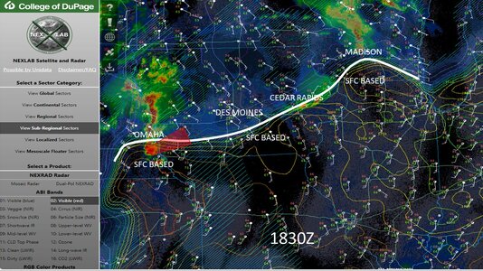
Just wanted to toss this CAPE/CIN line out .. looked like some of cool pooling was still evident.. and quickly showing a nice line , the one cell south of Omaha was TOR warned a bit ago

analysis.jpg
 
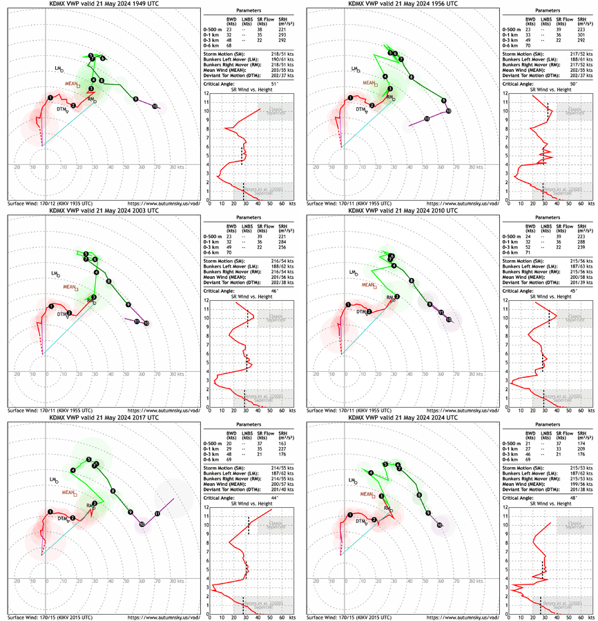
KDMX showing some S-shape (V-B) going on above 2 km. Making me hypothesize that this may be the reason we're not necessarily seeing "clean"/discrete supercells. Or perhaps it will somewhat suppress the total extent of tornadoes in what seems to be an outbreak developing.
 

Attachments

  • KDMX_loop.gif
    KDMX_loop.gif
    956.5 KB · Views: 15
That was quite the cell along US34 producing multiple tornadoes, and fairly visible at that. Cells to the south appear ready to join in on the party and it will be interesting to see if they can maintain their minimal spacing in what is currently a broken line.
 
Have observed 4 tornadoes so far between Red Oak and Stringtown, IA, 2 at within a mile (audible). Red Oak observed full life cycle. Next two at their beginning stages, the third looks to be the one that struck Greenfield and the wind turbines at Carl. Fourth near Stringtown but buried in rain with low contrast. Really shocked at how this day evolved, did not expect this at all.
 
Back
Top