2024-05-21 EVENT: IA/IL/MO/KS/OK/AR

Jeff Duda

site owner, PhD
Staff member
Site owner
Supporter
Joined
Oct 7, 2008
Messages
3,768
Location
Denver, CO
Probably worth paying attention to the disturbance accompanied by SWly mid-level flow early to middle next week based on the CSU ML/AI guidance showing this:

severe_ml_day5_gefso_052212.png

which is quite high for what that system usually puts out.

GEFS seems to be in good agreement on supercell conducive conditions:
Screenshot 2024-05-17 at 10-28-01 COD NEXLAB Numerical Models.pngScreenshot 2024-05-17 at 10-27-56 COD NEXLAB Numerical Models.pngScreenshot 2024-05-17 at 10-27-50 COD NEXLAB Numerical Models.png

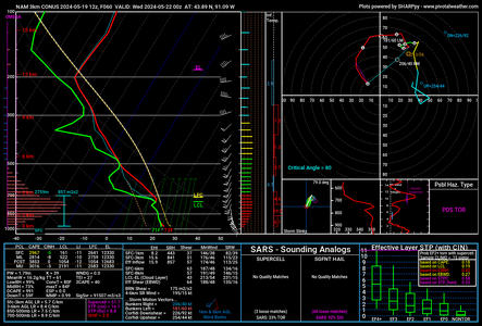
Deterministic GFS shows a broad and somewhat positively tilted trough with an axis over the northern Rockies this day. This results in fairly veered flow at all levels. Even surface winds look to struggle to back to the S and are more SSW throughout the warm sector. Pluses are great moisture for the time of year - dewpoints into the 70s well into OK and KS and possibly tipping 70 into IA/IL, but widespread upper 60s all throughout the warm sector. The moisture is deep, too. Pretty steep mid-level lapse rates as well, so high to extreme instability looks likely to materialize with a decent window where CIN drops enough to support sustained convection. Deep shear is also sufficient for supercells, although not super high.

Negatives are mostly the veered wind profile and many forecast soundings suggest some S-shape, thus possible issues with maintaining discrete supercells. Could also end up capped to the south and have little or no convective activity.
 
Veered surface-850 flow is less of an issue in the Midwest compared to the Plains, as we're generally less dependent on strong dryline convergence to initiate convection and we're further from the EML source region, so it's not like pointing a blow dryer at the low-level moisture. It can reduce directional shear, though unless your 500s and up are equivalently veered to westerly or even northwesterly (as is more common from June and on through the summer). However, we can get tornadic events where most of our environmental SRH comes from speed shear with only modest clockwise turning with height; plus strong 3CAPE.
 
Just throwing my two cents in here, but the NAM 3km CONUS is red hot for this event from Iowa into southwestern Wisconsin, edging into central WI in the 4 to 8pm timeframe. Surface wind fields look good with big looping hodographs as well across several models. Obviously, one can't depend on a single model, but this particular run is sending up caution signs. Take a look at this screengrab for 7pm in northeast Adams/western Waushara counties in WI. I would not jump on any sort of "this is going to be huge event" local-area band wagon, since other models do vary with the northern extent of good CAPE values, etc. Regardless, we'll need to watch how this evolves up here in the Badger State.
 

Attachments

  • nam4km_2024051912_060_43.89--91.09.png
    nam4km_2024051912_060_43.89--91.09.png
    247.2 KB · Views: 12
Tuesday certainly does have a very high ceiling for the upper Midwest region; but as always there is a lot of model disagreement and some potential flies in the ointment. Best case scenario from a chasing standpoint is something on the caliber of a 3/31/23 or 4/26/24, which is certainly on the table given the general pattern. Still, will have to see how early rounds of convection affect the warm sector. This is particularly relevant for the Wisconsin portion of the target where SRH becomes extreme along/just north of the warm front; but midday convection such as is depicted on the 3KM NAM and HRW FV3 might prevent that area from destabilizing. I'm also not a fan of the wonky upper-level hodographs being shown on most NAM/3KM NAM soundings. This would allow for storms to rain into their own updraft region (HP mode) whereas for 3/31/23 the upper levels were well-vented off to the north-northeast with the result being my avatar.

However, overdoing this at the Day 3-4 range may be a quirk of the NAM, as I was seeing it with 4/26 this year as well and it gradually became less of an issue as the day drew closer. Just another thing to keep an eye on.
 
Not quite as optimistic for tomorrow at least in terms of good chase potential as I was 24 hours ago, although it should still hold significant severe weather potential somewhere in the region. CAM range has muddled rather than clarified the picture, with different solutions depicting multiple waves of convection in different places at different times.

12Z HRRR and 3KM NAM are wildly different with the latter, surprisingly being the one to suggest a more discrete mode in the later afternoon/early evening hours colocated with a highly volatile tornado parameter space.
 
As a general rule, I favor the northeastern quadrant of an arc of storms for tornadoes. I think that will be the best play on Tuesday. The core of the jet is shown over the warm sector at 21z, so this event may get going early. Fast storm motions northeast are the main challenge. I'm thinking of positioning on I-80 and intercepting storms as they cross the interstate, then moving east to the next one in the line. CAMs show lead storms ahead of the line that will also be players.

Farther south along the Highway 36 and I-70 corridors looks conditional, but could still go big. Storm motions will be more easterly and easily chaseable there, but I've been left empty-handed many times by choosing the southeastern quadrant of the supercell arc because it was going to impact St. Louis. As long as my home area stays east of that, I'm likely staying on the I-80 corridor.

The other factor is that I'll likely end up somewhere around North Platte and Kearney tonight, so getting to the southern target area in time will be more of a challenge.
 
Been following more of the northern extent of the system moving through tomorrow. Seems to be trending more "messy" on the northern end, towards the low pressure center, which is more of a heavy rain signal to me. 12z HRRR depicted a line of storms forming over eastern Iowa. Guess it will be a question if they stay discrete or if it goes linear as it moves into Illinois and maybe perhaps far southern Wisconsin. Virtual target would be Cedar Rapids, IA as of right now.

Biggest question is with the rounds of storms moving through the region over the next 24 hours, how much destabilization will occur, if any?
 
Seems like half of Iowa will have the challenge of all that nocturnal convection and boundary layer/cloud debris reset to deal with, but the dynamics along, south and ahead of the front is certainly going to elevate convection later in the day, which looks like a QLCS setup with some semi discrete and embedded spin-ups, and maybe some tail-end Charlie chase.

I think the more interesting area will be where the retreating overnight outflow bndry interacts with good confluence and cleaner, theta rich, air in Northern IL. which if the models are correct, discrete convection IVO Cedar Rapids and east ahead of the main line seems possible. I think I would hang out/Start around Rochelle IL, shooting maybe NorthWest to Debuque to intercept (depending on CI locations), then zig zag back to Rockford/Madison (In that box) and keep a real close eye on the interaction of confluence lines mixing with the previous night's outflow boundary. the air looks clean from Peoria up to Rockford. Storm motions will be a challenge keeping ahead of it (I saw a range of 40-50kts). Models have trended this area for discrete activity for several runs now.
 
Not quite as optimistic for tomorrow at least in terms of good chase potential as I was 24 hours ago, although it should still hold significant severe weather potential somewhere in the region. CAM range has muddled rather than clarified the picture, with different solutions depicting multiple waves of convection in different places at different times.

12Z HRRR and 3KM NAM are wildly different with the latter, surprisingly being the one to suggest a more discrete mode in the later afternoon/early evening hours colocated with a highly volatile tornado parameter space.
I think you're right about the run to run differences,, I almost never look at runs besides 00/12, even for CAMS.. I guess it goes back to the whole best/most data for the 00/12run mentality, which I know doesn't really apply to CAMS , but I will say I see more agreement between 00/12 than the intermediate runs in between (someone is going to say I'm wrong lol... probably Jeff Duda, lol)
 
Thinking about targeting the Waterloo-Webster City area. Multiple HRRR runs and the 06Z 3K NAM suggest slightly better backing of the surface winds in north-central to northeast Iowa, with a relative maximum of 3CAPE/EHI and some discrete-ish cells making their way through there in the afternoon. Besides, along and north of the US-20 corridor is the best chase terrain in Iowa. Almost as flat and open as western Kansas. I got lucky that Keota was in a fairly open spot along Highway 92 but encountered issues with hills and trees while trying to chase it toward Wellman/Kalona.

...it also helps that the HRRR has backed off its one-run idea of a rogue supercell in a potent tornado environment making a bulls-eye on Madison. ;)
 
I am sitting this one out. After chasing near Akron CO yesterday, we stayed the night in Colby. Had thought about bailing north into Nebraska at dark, but decided to avoid driving in heavy rain at night and dropped south to have a look at the southernmost supercell before heading east. So now it's at least five and a half hours just to Omaha, early initiation, strong forcing, surging cold front, near 50 knot storm motions, mid-level flow and shear vectors mostly parallel to the front, and it would be a fool's errand. If it were closer I would give it a shot, what the hell. But there's a cost/benefit, or risk/reward, to every chase, and this one doesn't seem worth it to me, especially with targets over the next couple of days (quality notwithstanding) back on the southern/central Plains. A final consideration is that I am trying to juggle this "work remotely and chase as needed" setup for the first time, and trying to conserve the PTO time and not ask people to cover for me too many times so I can stay out here longer (although, sadly, that may turn out to be a fool's errand as well).
 
Echoing the sentiments of @JamesCaruso I am also sitting this one out. I started chasing on similar setups in the Midwest. Such fast storm motions are very difficult to chase. You'd really need to stay on I-80, which I don't think is the prime location. The other strategy would be to stay well upstream, wait for a long-track tornado to be ongoing on one of the cells, and position yourself to intercept it. It's really more spotting than it is chasing. Once it passes you, you'll struggle to keep contact with it. Also, to get to NE Iowa I would have darn near had to pull an all-nighter. This would also eliminate the possibility of chasing tomorrow.

Nonetheless, it appears the concern for atmosphere recovery is no longer existent. I do still have concerns of this going completely linear, particularly with southern extent, as is always a possibility with a cold front undercutting storms. Best of luck to those chasing, and please stay safe everyone!
 
Very messy day with morning convection across the Northern Plains. A small window may open up towards nightfall across eastern IA and northern IL, but it feels like storm mode will be more windbag-ish/linear than super cellar. Not that I could get out of work today, but it doesn't feel like an ideal chase day with the timing. I'm completely bored with today's setup.
 
We also are sitting it out. Even if we got there in time (too late now) storm motions of over 50 mph and the N-S orientation of the line means that even if you do see a tornado you are likely one and done. Been there, and did not care for it. Heading south for what looks like several days in TX.
 
Missouri has some things going for it, hard as it is for this Jayhawk to type it. Can it live up to the Show-Me State?

Look at the upper-level charts and hodos shows that turning with height is superior down by I-70. Mid-level winds cross the surface trough better down in Mizzou. Obviously terrain south of I-70 is a mess. However north of I-70 Missouri is quite doable.

I cannot discern a west-east boundary in Missouri at this time. There are hints of some variable 1K SRH on the NAM, but nothing jumps out on surface or visible. Ahead of the main front a slight surface trough may form, but that's another north-south boundary. I prefer boundary intersections.

Morning rain along the Iowa Missouri border could spit out a little boundary, but it'll be fighting mixing and the strong synoptic background. If such a thing can set up, Missouri storm motions will be slower than those farther north.
 
Back
Top