2024-05-19 REPORTS: NE/KS/OK

Joined
Jan 14, 2011
Messages
3,217
Location
St. Louis
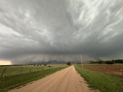
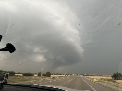
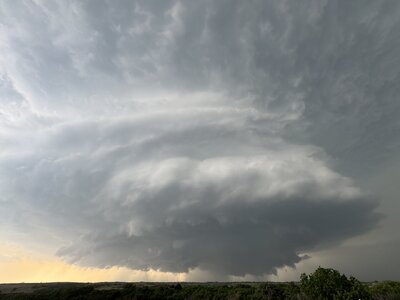
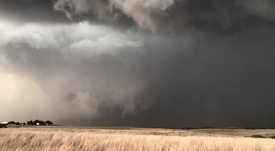
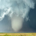
Started the day in Salina and initially headed toward Pratt. I intended to just stay ahead of the derecho while keeping the Oklahoma suercell as an option. After some indecision, I changed course at Hutchinson and went northwest to intercept the supercell along I-70 at Hays. It was tracking along an outflow boundary, with easterly surface winds and increasing instability ahead of it. I reached this storm at Russell. I stayed ahead of it on the interstate eastbound to Salina. The storm was pushing outflow far ahead, but it managed to kink the outflow a couple of times and spin up some mesovortex tornadoes - at least one of which looked strong. The first one west of Russell I may have seen, but need to review my video. The second one - a big dusty tornado northwest of Dorrance - was very distinct:

may1924a.jpg


may1924b.jpg


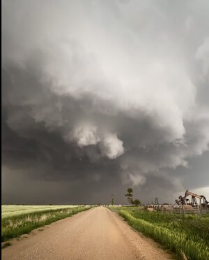
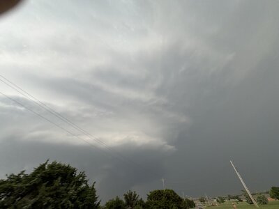
I went north to get closer, but the tornado became rain wrapped fairly quickly:

may1924f.jpg

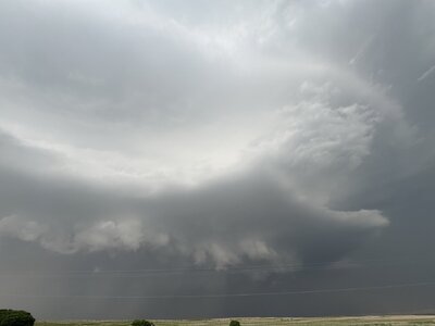
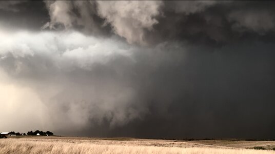
Shortly thereafter, the outflow consolidated as the storm evolved into a 100mph-gust producing bow echo:

may1924e.jpg


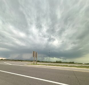
I went south on I-135 to get out of the way of this and headed down to Wichita to let the main derecho (not sure if it met that criteria yet) pass over. This was somewhat disappointing, with no structure or haboob on the leading edge. I waited for the stratiform region to arrive so I could shoot upward lightning at the towers in Colwich, but the southern part of the MCS was retreating northward and no stratiform was upstream. I went back north to Newton to try and find some wind turbines or other towers, locating one on the south side of Newton. Two upward flashes happened to it as I approached. One was visible on my dashcam, along with a more distant one possibly from the Colwich towers:

may1924c.jpg


After I set up my main cameras, the storm would not do it again. New storms continued to go up behind the line over Newton. Again, most of this lightning was uncooperative, but I did catch one nice slow positive CG on both a still and 6,000fps high speed.

may1924d.jpg


I drove up to Russell for the night in preparation for the next day's event.
 
Last edited:
This was also our "fly out" day so I didn't have high expectations. I had been hoping for a warm front play in north-central KS, easier to get to from KC where we were flying in. Southwest KS and northwest OK were out of range. Ideally we would have flown into Wichita to target those areas, but the flight logistics were more challenging/inconvenient. Also I get paranoid about rental vehicle quality and KC has a much better selection than Wichita. Sure enough, the vehicle we were given had three tires at 40 psi and one at 30 psi. I asked for a new vehicle and got a nice Expedition with only 1,000 miles on it.

The second the flight touched down, I checked data and saw that the OFB was along I-70 and this was now the effective warm front. We left the airport around 1:30 and went west on I-70 without a clear target, just generally trying to get as far west as possible and decide our next move in Salina. It was more of a nowcasting situation. When the first tornado report came out at Gorham in Ruseell County at 3:27, we were still in Junction City. When the third tornado report came out at Wilson at 4:23, we were still only about a quarter to a third of the way between Salina and Wilson. Our last chance to exit I-70 without running right into the storm and being trapped with no escape was at the road that runs between Glendale and Brookville. The time was about 4:40pm. The next exit was route 14 to Lincoln and Ellsworth; that would have been too close for comfort and would already be overrun by the storm by the time we got there. It was tough to find a good viewing location in Glendale but when we finally did, we saw this - similar to Dan's pic above, already passed its peak.

Upscale growth was already occurring to the south, so we went south to Brookville and then east to I-135 just west to Salina. Rather than keep moving east ahead of it, I decided to call the chase and head to Hays for the night behind the MCS. We took cover under the I-135 overpass to let a hail core pass. We were completely on the shoulder, which was on the left side of the road, but some other idiots blocked part of the right lane and a complete selfish moron decided to stop in the left lane, completely blocking traffic. A short time later, a police officer came through and cleared out those who were blocking lanes.

Once the hail had passed to the east, we went north on I-135 and west on I-70. The crosswinds were incredible, and we saw three separate tractor trailers blown over, likely when the tornadic circulation had come through. When we passed through Wilson, we saw a highway sign bent and twisted. When you see these things, there's always the possibility it's been that way for a while, but we also saw some shredded greenery in the same area.
 

Attachments

  • IMG_8700.jpeg
    IMG_8700.jpeg
    172.1 KB · Views: 13
I forgot to add the most important part to my report, or maybe I was just blocking it out… We probably could have made it in time for the tornado if we hadn’t stopped for food and gas… I was so far away from the storm that the whole effort seemed futile, and what’s 15-20 minutes when you’re already so far away, and haven’t eaten or even had more than a cup of water on the flight… But in retrospect, I wish we had just kept blasting west and saved the food and fuel for later.

For me it’s not a chase if I don’t have something to ruminate over and second-guess myself for.

On the other hand, I can be George Costanza and do the opposite, and be grateful that I saw anything at all, always tough to do on fly-in day…. Certainly an eventful day, hard to believe it had started back home in the Philadelphia area at a 6:45am Mass and ended in Hays KS after seeing a supercell and driving around overturned tractor trailers in high wind and hail.
 
Made my way to Woodward by mid-afternoon and considered going out to the panhandle to chase Tail End Charlie, but stuck to my guns when initiation took place near Canadian, Texas. I meandered my way south of my location and ended up near Higgins, Texas when three initial cells merged into one. It slowly made its way east, developing structure that rivaled some of the best I've seen. I stayed along with it until it went to Butler, then I dropped south a bit so I could see due to its HP nature. Of course, that guarantees a tornado will produce and sure enough near Custer City it put down a wedge (I believe), which I missed. Ran into a family member and basically chased in separate vehicles with them which changed the nature of my chase because they wanted to avoid hail, wind, etc. but that's ok I had fun anyways. One of the most fun chases in recent memory.

Edit: Just wanted to add, it was one of those "Drive four hours away only to have tornadoes touch down five miles from your house" days. :rolleyes: 😜

A Day to Remember.jpg
 
Targeted western Oklahoma for day 1 of this years chasecation; followed this storm from beginning all the way through Custer city until sunset. Captured the large wedge tornado and had plenty of structure in between. A great start to what became a very memorable week with 4 tornado days out of 7 days of chasing
 

Attachments

  • IMG_1022.jpeg
    IMG_1022.jpeg
    139.7 KB · Views: 7
  • IMG_1071.jpeg
    IMG_1071.jpeg
    141.3 KB · Views: 8
  • IMG_0877.jpeg
    IMG_0877.jpeg
    92.5 KB · Views: 8
  • IMG_0916.jpeg
    IMG_0916.jpeg
    100.5 KB · Views: 7
  • IMG_0934.jpeg
    IMG_0934.jpeg
    131.4 KB · Views: 7
  • IMG_0953.jpeg
    IMG_0953.jpeg
    63.6 KB · Views: 7
Finally finished this one. One of the more "perfect" chases in recent memory. Drove a few hours west, almost screwed up navigation, recovered, saw structure, saw a whhhedge, then a couple more tornadoes closer to home before ending up 45 minutes from my house.

Chase recap is posted

Custer City Wedge View.jpg20240519-Supercell_Structure_in_Western_Oklahoma.jpg
 
Back
Top