Andy Wehrle
EF5
After the day dawned with only a marginal risk of severe weather north of I-80 in Illinois (on the 06Z and 13Z SPC outlooks, the maximum tornado risk was 2% within 25 miles of a point, and the area where these tornadoes occurred wasn't even included in that), conditions rapidly changed for a significant tornado threat from I-39 to the Chicago metro, so after glancing over the data I headed out for an impromptu after-work chase.
I set up at Davis Junction, along I-39 between Rockford and Rochelle, in the mid-afternoon. A cell fired just to the west near Byron and I began following it east along State Highway 72, soon cutting south to Highway 64 but it didn't seem in any hurry to do much of anything. There was some thought that a relatively short window for destabilization following an earlier round of rain and storms would end up limiting the tornado potential after all, but something told me to stick with the storm. Perhaps it was the fact that as I crossed the state line on my drive down, I had seen very low clouds moving very rapidly in different directions...a visual manifestation of strong low-level shear. Nearly every chase day I've had when there have been tornadoes in the area (whether I saw anything of them or not), I've observed this phenomenon.
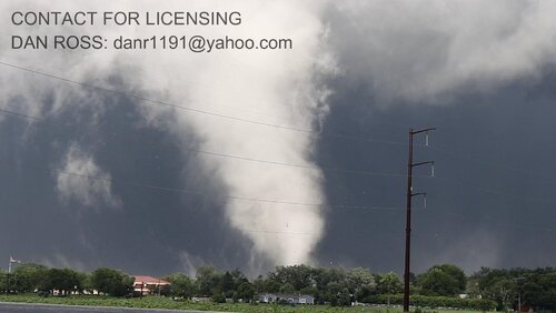
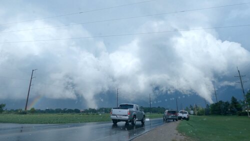
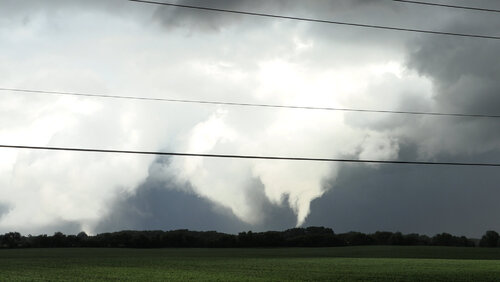
Shortly after I passed Lily Lake, a dramatic uptick in lightning detection on RadarScope occurred with the storm, followed by a blast of inflow rocking my car. I intended to turn north at Wasco toward Campton Hills; as I did so a tight velocity couplet abruptly appeared and a WEA for a tornado warning blared over my phone. As the video begins I emerge from the rain and trees at the intersection of Corron Rd. and Silver Glen Rd. to see, to my amazement, not one but two brilliantly-sunlit white tornadoes churning to my north-northeast. I turned east on Silver Glen Rd. to follow their eastward motion, which was probably a mistake (should have continued up Corron to the next east-west road). As the video ends you can see the death knell of my chase...trees! After this point, Silver Glen was completely lined with trees as it entered South Elgin and T'd out at State Highway 31 and the Fox River, and I didn't get another view of the tornado(es) after this.
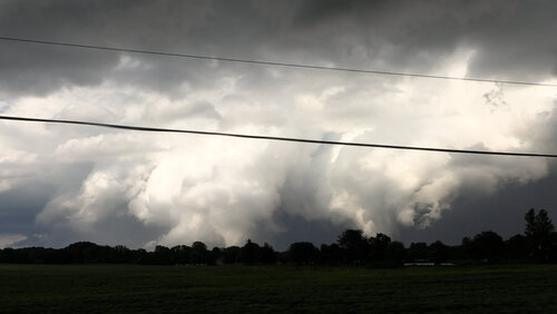
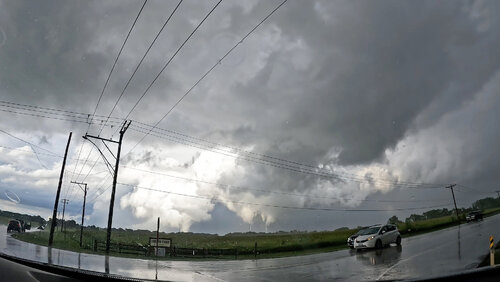
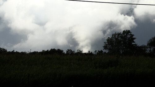
Images are video frame grabs, first from my dash-mounted GoPro and the other two from my 4K camcorder.
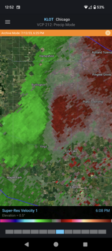
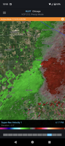
Part of my problem was I didn't interpret the rather non-standard storm structure correctly...I kept trying to hug the southern flank, where it appeared a hook would occasionally try to form, while velocity showed a broad couplet further north, where I assumed it would be buried in rain according to reflectivity. It wasn't apparent to me that this was the real deal until the couplet abruptly intensified just before producing. I also kept expecting the storm to turn hard right, moving SE along the warm front, but the tornadoes just kept moving almost due east.
At present, the larger (left, northern) tornado has been rated EF1, and the closer but smaller right/southern tornado EF0 per preliminary survey from NWS LOT.
I set up at Davis Junction, along I-39 between Rockford and Rochelle, in the mid-afternoon. A cell fired just to the west near Byron and I began following it east along State Highway 72, soon cutting south to Highway 64 but it didn't seem in any hurry to do much of anything. There was some thought that a relatively short window for destabilization following an earlier round of rain and storms would end up limiting the tornado potential after all, but something told me to stick with the storm. Perhaps it was the fact that as I crossed the state line on my drive down, I had seen very low clouds moving very rapidly in different directions...a visual manifestation of strong low-level shear. Nearly every chase day I've had when there have been tornadoes in the area (whether I saw anything of them or not), I've observed this phenomenon.
Shortly after I passed Lily Lake, a dramatic uptick in lightning detection on RadarScope occurred with the storm, followed by a blast of inflow rocking my car. I intended to turn north at Wasco toward Campton Hills; as I did so a tight velocity couplet abruptly appeared and a WEA for a tornado warning blared over my phone. As the video begins I emerge from the rain and trees at the intersection of Corron Rd. and Silver Glen Rd. to see, to my amazement, not one but two brilliantly-sunlit white tornadoes churning to my north-northeast. I turned east on Silver Glen Rd. to follow their eastward motion, which was probably a mistake (should have continued up Corron to the next east-west road). As the video ends you can see the death knell of my chase...trees! After this point, Silver Glen was completely lined with trees as it entered South Elgin and T'd out at State Highway 31 and the Fox River, and I didn't get another view of the tornado(es) after this.
Images are video frame grabs, first from my dash-mounted GoPro and the other two from my 4K camcorder.


Part of my problem was I didn't interpret the rather non-standard storm structure correctly...I kept trying to hug the southern flank, where it appeared a hook would occasionally try to form, while velocity showed a broad couplet further north, where I assumed it would be buried in rain according to reflectivity. It wasn't apparent to me that this was the real deal until the couplet abruptly intensified just before producing. I also kept expecting the storm to turn hard right, moving SE along the warm front, but the tornadoes just kept moving almost due east.
At present, the larger (left, northern) tornado has been rated EF1, and the closer but smaller right/southern tornado EF0 per preliminary survey from NWS LOT.

