2023-06-17 REPORTS: OK/TX/KS/NM/C0

John Farley

Supporter
Joined
Apr 1, 2004
Messages
1,854
Location
Pagosa Springs, CO
There was a thread for this day earlier (albeit with the wrong date), but it seems to have disappeared. So I am starting one with the right date. Starting in Springfield, CO and waiting a little too long for isolated supercells to form ahead of the squall line in southeast CO (did not happen), I was a little late to the show in the OK Panhandle, so did not get the great pictures or videos of the Beaver storm that some others did. But I did see it and get some pictures, and even looking at it from well to the west, it was impressive, with visible rotation at times even with a distant view through the rain. This is representative of my view of this storm:
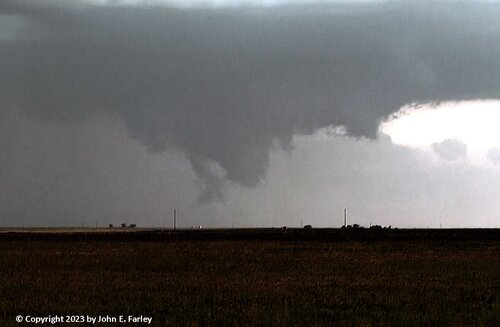
chase61723-2.jpg

What I did have a much better view of was the next storm west, also a supercell. which moved from near Hooker to near Turpin before being absorbed by the surging squall line. From my position southwest of Turpin, I was able to get video of some nice cloud-base rotation:

Hooker to Turpin. OK supercell and cloud-base rotation - June 17, 2023 - YouTube

Not long after that passed, I was overtaken by the surging squall line, which met the criteria for a derecho as it produced severe wind from southern CO and northern NM all the way across OK and into AR and beyond. At my location it produced high wind, a gustnado, 1-inch hail, and some spectacular lightning, all of which can be seen on this video clip:

Derecho near Turpin, OK, June 17, 2023 - High Wind, Gustnado, Hail, Lightning - YouTube

If you are interested, you can read my full account of this chase and see more pictures at:

johnefarley.com/chase61723.htm
 
Good day all, this is my reports for June 17, 2023 in Oklahoma...

Summary: June 17 was a pretty successful chase day with a rather complex forecast and a target area nailed in the Oklahoma Panhandle, with a primary target of May, Oklahoma (northwest of Fort Supply and east of Beaver). I checked out of my hotel in Liberal, checking a few places for an oil change for my vehicle, which proved to be impossible. I grabbed lunch there and headed south out of Liberal on Highway 83, crossing into Oklahoma. With time to kill, I continued south into Texas, to check out the tornado damage in Perryton from the June 15 tornado. The SPC had a large enhanced-risk area in place, with a lobe of those probabilities extending SE to NW across the Oklahoma Panhandle. This area (and the target region) was in a 5% tornado probability, with the majority of the enhanced-risk area in 30% (hatched for significant) probabilities for both wind and hail. The plan of the day was to catch the supercells before a late day MCS approaching from the west under-cuts the target area. I left Perryton via SR 15 and north on SR 23 to wait in Elmwood, which is a nearly deserted town on the intersection of SR 23 and Highway 412 in Beaver County. Several chase teams were there as well, as we waited for cap erosion and convective initiation. Tony Laubach, and the TIV2 (Tornado Intercept Vehicle) group as there. Two abandoned animals were rescued by members of the TIV2 group. The SPC issued mesoscale discussion 1129, and subsequent tornado watch box 329, valid until 11 PM CDT. Convective initiation began in an agitated TCU field west of Highways 83 and 412 by about 4:30 PM CDT. This area quickly and explosively developed into a tornadic supercell, which tracked east from near Turpin and past Beaver north of Highway 412, and eventually to near Fort Supply and Harper County. Some giant hail and weak tornadoes were observed with this supercell. The chase ended near Fort Supply and along Highway 270, with a hasty check-in to a hotel in Woodward, Oklahoma, where I spend the night.

Full online chase log for 2023 (including this one) can be found here: www.sky-chaser.com/mwcl2023.htm

Details (on June 17)...

1). June 17, 6:00 PM
- Observation and indirect penetration of an extremely severe and cyclic tornadic thunderstorm from near Turpin, Oklahoma and Highway 83 in Beaver County, and eastward near and north of Highways 412 and 270 into Harper County near May and Fort Supply. The storm started as a classic supercell, then evolved to HP mode, eventually growing up-scale as a powerful MCS overtook it around dusk. Two tornadoes were observed with this storm, one a dust swirl beneath a funnel on the wall cloud south of Turpin, and another larger, multi-vortex type weak tornado with occasional ground contact south of Beaver. The latter had very fast-moving cloud motion at cloud base, with a large, blocky and striated wall cloud. The core of the storm was not directly penetrated, but hail stones at least 3" were noted across the road between Beaver and Turpin on a country (EW 12) road. Other conditions encountered were 70+ MPH winds, especially in RFD and rear-inflow, heavy rains, and frequent lightning. The storm remained mainly over rural areas of Beaver and Harper counties. Conditions causing the storms were surface heating, a low pressure area, dryline, surface boundary interactions, and an upper trough. Documentation was digital stills and HD video (including time-lapse). A 2022 Jeep Renegade was used to chase the storm. A tornado watch was valid for the area until 11 PM CDT.

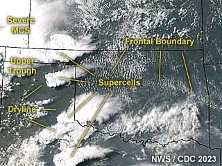
m24sat26.jpg

Above: This an annotated visible satellite image at roughly 23z (late afternoon) on June 17, 2023 showing the synoptic environment. A tornado-warned supercell amongst other storms are present across the Oklahoma Panhandle area.

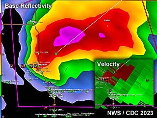
m24rad26.jpg

Above: This is a radar image (base reflectivity) of a tornado warned supercell near Beaver, Oklahoma at roughly 6 PM CDT. The Doppler velocity of the storm is in the lower-right inset.

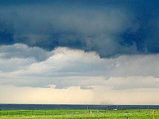
m24tor37.jpg

Above: Weak tornado, with ground circulation confirming ground contact. The view is to the west and northwest.

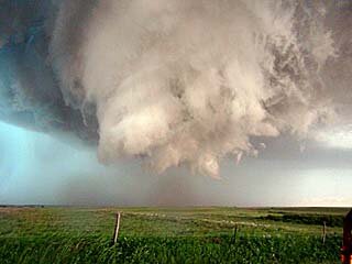
m24wc10.jpg

Above: Incredible motion of wall cloud and funnels south of Beaver, Oklahoma nearing Highway 270. Possible multi-vortex tornado, albeit weak ground circulation - if any. The view is to the north and northeast.

m24gf6.jpg

Above: Incredible shelf cloud and gust front associated with a powerful derecho-like MCS racing eastward just after sunset! The view is to the southwest.
 
Back
Top