Tony Laubach
EF5
First Colorado tornado of the year! And for the first time after living in Colorado most of my adult life, I can finally say I saw the first one of any given year... haha
Wasn't planning to chase at all this week; had talked myself out of Tuesday in Texas (added that to the thread as I know a few folks played in some marginally severe hail) and certainly had no thoughts on chasing the backyard, either. Well, when I awakened in the morning, two things stood out to me. First of all, I probably needed to be in central Texas on Wednesday, and secondly, uh, is this a DCVZ I should be watching?
Well, I contacted my people and informed them that I am reconsidering the Texas option for Wednesday, and that I'd leave Colorado later in the afternoon on Tuesday to drive halfway. I had some production/editing stuff to wrap up Tuesday morning, so I knocked that out and lollygagged around packing and loading the car. When I opened the garage door to load the truck, I immediately noticed some impressive towers to my immediate east. Of course, I opened the radar app on my phone and saw this...
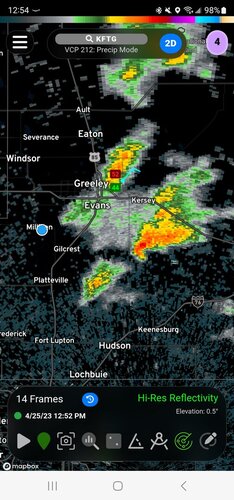
"Holy $h!t!" I uttered (and yes, I actually said "holy $h!t), and suddenly lollygagging was kicked into a type of overdrive where when I arrived to my Amarillo hotel later that night, I wondered why and how I packed some of the crap I did. Needless to say, bags were tossed in the car, accessories, whatever else I hastily thought of, making sure I forgot nothing, thus over-packing everything. I kissed my wife and busted out the door, and for the first time in God-knows-how-many-trips, did not return to the house to get something I forgot.
The storm was sinking south... slowly... fortunately it was "kinda on the way" to where I was aiming for my overnight stop. Having had a roughly 4PM departure in mind when I made my plans this morning, I had basically given myself a three-hour window to play with this thing. And if you know DCVZ setups, the tornado potential with these is typically pretty early, so I figured this was all-too-perfect. No way this would work, right... RIGHT???
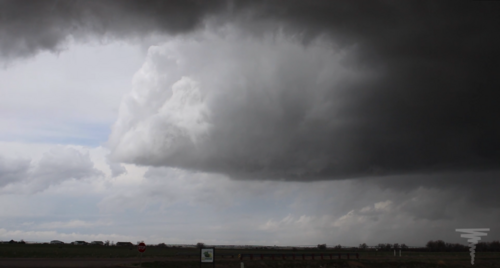
I dropped south to Platteville on US-85, then cut east from there over toward Milton Reservoir, setting up on the Weld County Parkway, a route that runs north and south from US-34 down to I-76; it's a fantastic and quick route, and the storm was sliding south just east of that road. Visually, it looked impressive, and while there was occasional rotation, there was nothing that appeared imminently tornadic. Brilliant sheets of white indicated a massive amount of hail, but these early season storms aren't typically BIG hail producers, but big AMOUNTS of small hail. The storm was not warned, but clearly was an ice machine. Meanwhile, a few non-tornadic ground swirlies did get kicked up. A taste of things to come...
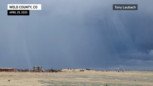
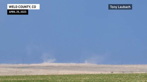
The core of the storm was starting to settle in along I-76 between Keenesburg and Roggin, and with no increasing tornadic potential, it was go time for hail! I jumped on I-76 and got into the early part of the core up near Roggin. Again, all sub-severe in size, but copious amounts of it. I circled from Roggin back to Platteville as I realized I was at less than 1/4 tank, and with the storm soon to be rolling into Keenesburg-proper, I figured a gas station would be perfect cover. I rolled in, filled up, and perfectly on cue, here came the hail! Brilliant contrast as the hail came down. This would kick off what I think was nearly 40-minutes or more of constant downpour of sub-severe hail. Nothing bigger than a penny, but when all was said and done, there was several inches deep of hail in the town. I won't hang around long enough to see that, cause...
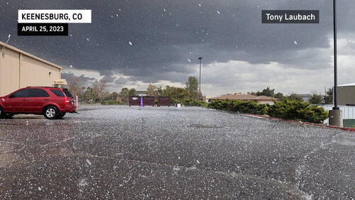
In the midst of my hailscapade, suddenly my phones and weather radio went off; Tornado-Warning, Radar-Indicated. Being on the south side of the storm, I had a good view in every direction that wasn't blocked by the hailcore. Nothing caught my eye, but soon my ears were filled with tornado-sirens. I figured I was in a good place to keep playing in the hail and so long as I keep my head on a swivel, I will see anything that may pop up. A few moments later, the warning was updated to OBSERVED, to which I again Exorcist my head and sure as heck, there it was to my south.
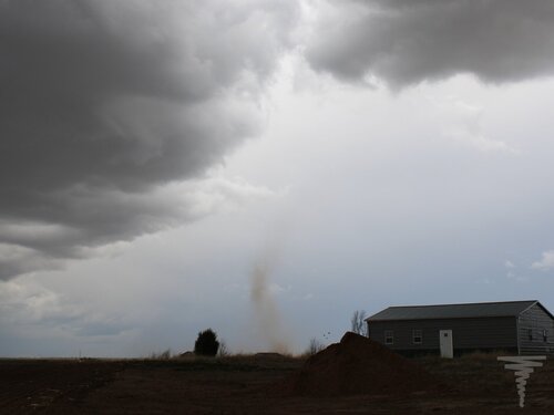
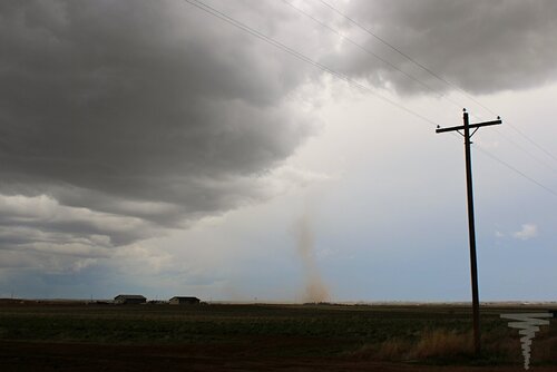
Hail fun over, I took County Road 59 south passed CO-52 and had a fantastic view of the growing spout from the north. I stopped on several occasions to get steady video of the spout, but proceeded to get closer and closer, trying to find the right gridwork of roads to get me there.
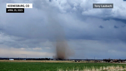
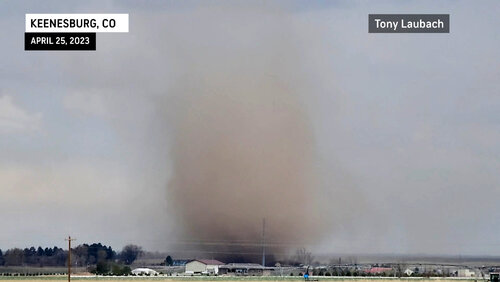
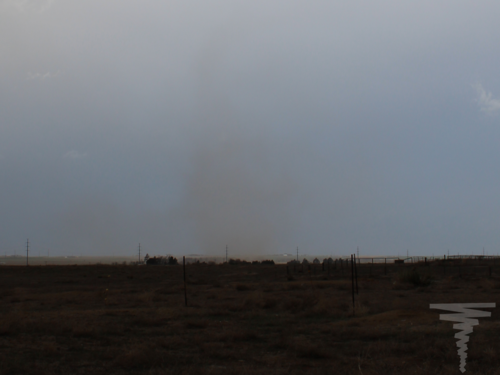
The cloud cinnamon bun was pretty much overhead and a tad east of me, while the ground circulation was a mile or so south. It was clear the path of contact between the two even as there was never full condensation. Based on my dash cam, I'd say I was probably watching this for the better part of 15 minutes, eventually the spout dissipating less than a quarter-mile to my west on County Road something southeast of Keenesburg.
I ran into a couple of local chasers whom I haven't met before (if you're here, raise your hand). We patted each other on the backs, and I proceeded to get over to CO-79 where I watched the developing line of storms to my west enroute to Bennett where I called it a day and proceeded happily to Amarillo to set up for Wednesday's Texas chase.
Landspouts are "easy" tornadoes, if you're there. Typically these setups aren't well telegraphed in advanced, and you really need to be there before storms form, cause they happen early in the lifecycle, and unless you're by default super close, you're not going to arrive in time. Fortunately, this storm presented itself 10 minutes from my house, and allowed me that opportunity, to which despite me living many years in Colorado, to actually see a legit landspout tornado of this magnitude. So yeah, it was super cool to finally succeed in an endeavor that contrary to popular belief, it not all that easy to do. In addition, it was a great hailer to play under, too... you won't lose a windshield to penny-size hail, but you may need to shovel your way out if you sit in one place too long. Some of the imagery post-storm was incredible; looked like snow, which was appropriate given the large amount of snow expected to fall nearby just hours after this. It wouldn't surprise me if there was still some hail piled up in a shadowy corner somewhere down there.
80 miles, that's what I formally logged for this trip, ending the chase officially at Bennett before I made my way to Texas. A great early season Colorado day, and bragging rights to say I was on the first tornado for the state in 2023... hoping there will be many more to follow later this Spring.
Wasn't planning to chase at all this week; had talked myself out of Tuesday in Texas (added that to the thread as I know a few folks played in some marginally severe hail) and certainly had no thoughts on chasing the backyard, either. Well, when I awakened in the morning, two things stood out to me. First of all, I probably needed to be in central Texas on Wednesday, and secondly, uh, is this a DCVZ I should be watching?
Well, I contacted my people and informed them that I am reconsidering the Texas option for Wednesday, and that I'd leave Colorado later in the afternoon on Tuesday to drive halfway. I had some production/editing stuff to wrap up Tuesday morning, so I knocked that out and lollygagged around packing and loading the car. When I opened the garage door to load the truck, I immediately noticed some impressive towers to my immediate east. Of course, I opened the radar app on my phone and saw this...

"Holy $h!t!" I uttered (and yes, I actually said "holy $h!t), and suddenly lollygagging was kicked into a type of overdrive where when I arrived to my Amarillo hotel later that night, I wondered why and how I packed some of the crap I did. Needless to say, bags were tossed in the car, accessories, whatever else I hastily thought of, making sure I forgot nothing, thus over-packing everything. I kissed my wife and busted out the door, and for the first time in God-knows-how-many-trips, did not return to the house to get something I forgot.
The storm was sinking south... slowly... fortunately it was "kinda on the way" to where I was aiming for my overnight stop. Having had a roughly 4PM departure in mind when I made my plans this morning, I had basically given myself a three-hour window to play with this thing. And if you know DCVZ setups, the tornado potential with these is typically pretty early, so I figured this was all-too-perfect. No way this would work, right... RIGHT???
I dropped south to Platteville on US-85, then cut east from there over toward Milton Reservoir, setting up on the Weld County Parkway, a route that runs north and south from US-34 down to I-76; it's a fantastic and quick route, and the storm was sliding south just east of that road. Visually, it looked impressive, and while there was occasional rotation, there was nothing that appeared imminently tornadic. Brilliant sheets of white indicated a massive amount of hail, but these early season storms aren't typically BIG hail producers, but big AMOUNTS of small hail. The storm was not warned, but clearly was an ice machine. Meanwhile, a few non-tornadic ground swirlies did get kicked up. A taste of things to come...


The core of the storm was starting to settle in along I-76 between Keenesburg and Roggin, and with no increasing tornadic potential, it was go time for hail! I jumped on I-76 and got into the early part of the core up near Roggin. Again, all sub-severe in size, but copious amounts of it. I circled from Roggin back to Platteville as I realized I was at less than 1/4 tank, and with the storm soon to be rolling into Keenesburg-proper, I figured a gas station would be perfect cover. I rolled in, filled up, and perfectly on cue, here came the hail! Brilliant contrast as the hail came down. This would kick off what I think was nearly 40-minutes or more of constant downpour of sub-severe hail. Nothing bigger than a penny, but when all was said and done, there was several inches deep of hail in the town. I won't hang around long enough to see that, cause...

In the midst of my hailscapade, suddenly my phones and weather radio went off; Tornado-Warning, Radar-Indicated. Being on the south side of the storm, I had a good view in every direction that wasn't blocked by the hailcore. Nothing caught my eye, but soon my ears were filled with tornado-sirens. I figured I was in a good place to keep playing in the hail and so long as I keep my head on a swivel, I will see anything that may pop up. A few moments later, the warning was updated to OBSERVED, to which I again Exorcist my head and sure as heck, there it was to my south.
Hail fun over, I took County Road 59 south passed CO-52 and had a fantastic view of the growing spout from the north. I stopped on several occasions to get steady video of the spout, but proceeded to get closer and closer, trying to find the right gridwork of roads to get me there.


The cloud cinnamon bun was pretty much overhead and a tad east of me, while the ground circulation was a mile or so south. It was clear the path of contact between the two even as there was never full condensation. Based on my dash cam, I'd say I was probably watching this for the better part of 15 minutes, eventually the spout dissipating less than a quarter-mile to my west on County Road something southeast of Keenesburg.
I ran into a couple of local chasers whom I haven't met before (if you're here, raise your hand). We patted each other on the backs, and I proceeded to get over to CO-79 where I watched the developing line of storms to my west enroute to Bennett where I called it a day and proceeded happily to Amarillo to set up for Wednesday's Texas chase.
Landspouts are "easy" tornadoes, if you're there. Typically these setups aren't well telegraphed in advanced, and you really need to be there before storms form, cause they happen early in the lifecycle, and unless you're by default super close, you're not going to arrive in time. Fortunately, this storm presented itself 10 minutes from my house, and allowed me that opportunity, to which despite me living many years in Colorado, to actually see a legit landspout tornado of this magnitude. So yeah, it was super cool to finally succeed in an endeavor that contrary to popular belief, it not all that easy to do. In addition, it was a great hailer to play under, too... you won't lose a windshield to penny-size hail, but you may need to shovel your way out if you sit in one place too long. Some of the imagery post-storm was incredible; looked like snow, which was appropriate given the large amount of snow expected to fall nearby just hours after this. It wouldn't surprise me if there was still some hail piled up in a shadowy corner somewhere down there.
80 miles, that's what I formally logged for this trip, ending the chase officially at Bennett before I made my way to Texas. A great early season Colorado day, and bragging rights to say I was on the first tornado for the state in 2023... hoping there will be many more to follow later this Spring.
Last edited:

