• A friendly and periodic reminder of the rules we use for fostering high SNR and quality conversation and interaction at Stormtrack: Forum rules

    P.S. - Nothing specific happened to prompt this message! No one is in trouble, there are no flame wars in effect, nor any inappropriate conversation ongoing. This is being posted sitewide as a casual refresher.

2023-04-19 Reports: OK/KS/NE/IA

Joined
May 19, 2020
Messages
103
Location
Eastern KS
An isolated supercell popped up in SC KS and eventually gained tornadic status in Western Chase County. It had 4 confirmed tornadoes in Chase County. We intercepted it in Eastern Chase/Western Lyon County. I am generally not a fan of chasing at night, but an isolated cell in a road network that I know like the back of my hand, was too much to pass up. We never even saw a hailstone. The storm had a well defined wall cloud at times, and I believe we saw a couple different funnels before the storm interacted with another storm and died. The only thing that would've made it better was more daylight. I didn't get many pictures as I was concentrating on keeping us safe on the roads and in relation to the storm. We were able to track along to the SE of the storm on dry roads and storm motion was ~30 mph so easy to keep up with. Some good pics people sent in from the local radio station. WEATHER: Two drivers hurt, sporadic damage near Cottonwood Falls and Strong City after possibly four tornadoes Wednesday | KVOE
IMG_20230419_215140.jpg20230419210649_LC11.jpg20230419_201802.jpg
 
I decided to target Seneca Kansas over going all the way to Lawton as I needed to be back at work in the morning. We ended up sitting at Fairview and watched initiation directly to our west over Seneca. We followed the cell all the way to Hamburg Iowa and it made an attempt to do something just before the river but never did.

I decided to go back to Rock Port and watch the next cell to the SW. It quickly wrapped up as we watched it go to the NW of Nebraska City. The second shot below is a quick cell phone shot as we approached the cell. The first shot below is when it dropped the first tornado just to the east of I-29 by Percival Iowa. It is dark at this time so my cell phone shots are yuck. We followed it as it tracked to the NE and dropped another quick tornado while maintaining a nice wall cloud for another 10 minutes or so. We called the chase at this time and headed back to KC arriving at 11pm.

Not the best photos due to the darkness but we saw two tornadoes JUST in time.
11.jpg22.jpg
 
Pretty unreal chase yesterday close to home. Was on the Cole/Etowah OK cyclic supercell from when it was west of Apache to after dusk. Left
Norman at about 4:30 PM and storms were already developing nicely on/ahead of the dryline in regions of broken cirrus, which represented a rather substantial model bust since most guidance was waiting until 00z for initiation. Noted an 84/66 observation at Duncan, which indicated that whatever cap that was still evident in the 19z OUN sounding was likely gone, and the storm growth supported that notion. Initially iffy LCLs seemed to be affecting the storm that tracked from near Chickasha to Norman and it never quite was able to consolidate its rotation (fortunately), although it had excellent structure for awhile. The base was a bit small.

DSC_0057.JPG

Eventually we slowly moved eastward from our initial position east of Tabler to a point east of Washington near I-35 via OK-74. As we looked back in the direction we came, the storm that became the show of the day was filling the western sky and it became obvious that something significant was likely going to happen. Warm, southeasterly moist inflow was constant, the updraft was very large, and multiple wall clouds were cycling through as a long inflow band representing the low-level jet began developing.

DSC_0088.JPG

What ensued following this stage was a spectacle that rivals anything else I've seen since I started chasing. Inflow continued to increase as the storm slowly moved east, forced ascent was evident as the storm began to take on more of a mothership look with striations. CGs were frequent in the vault area. Continued monitoring of the radar indicated that a tornado was becoming more of an inevitability than a question, especially as LCLs were lowering with eastward extent. The large lowering/wall cloud on the right in the following image is where the Cole tornado formed, although visibility was becoming somewhat poor due to rain wrapping around the circulation. Rapid motion was evident.

DSC_0107.JPG

I'll just post the next couple of wide-angle shots and let them speak for themselves. Absolutely crazy tornado/structure combo.

DSC_0137.JPG

DSC_0142.JPG

DSC_0149.JPG

Closer up shot of the Cole tornado (stovepipe), obviously the murkiness was a bit of a problem, but this was really a "structure first/tornado second" case.

DSC_0127.JPG

Eventually with the tornado getting lost in the rain and eventually occluding and the storm getting closer, we opted to reposition south and made our way through Purcell towards sunset. The structure continued to be absolutely wild, resembling the Electra TX supercell from 4/27/2021 and even the Dora NM storm from 5/26/2019 at times. Inflow was ripping at 40 mph, perhaps gusting to 50 mph at times, to the point where it was hard to open the car door. An orange tint filled the sky as the sun was setting.

DSC_0167.JPG

We finally ended up in a position off US-77 south of Purcell and simply watched the storm as dusk fell. Near constant lightning, the purplish tint to the sky, and mammatus on the backside of the anvil provided additional amazing photo opportunities. The following photo was taken about 30 minutes before the Etowah tornado developed.

DSC_0213.JPG

Given that night was quickly approaching, we made our way back through Purcell on US-77 to head back to Norman, watching the storm continue to be illuminated by both CGs and anvil crawlers. I caught a brief glimpse of the lowering where the Etowah tornado was (and therefore, the top of the tornado), but it was blocked by trees on the horizon. Nevertheless, two tornadoes, slow storm motions and the best storm structure I've seen without having to drive more than 40 minutes from home at any time made this quite the chase. Also rather nerve-wracking given the multiple tornadoes and very large hail close to home. Norman dodged a major bullet with this one.

Unfortunately, this also became the first fatal tornado that I've chased, which puts a damper on an otherwise spectacular day, as did the damage east towards Etowah, Bethel Acres, and Shawnee. I wish the best to all of the families affected, and would be eager to contribute to relief efforts.

I should also mention that the 00z OUN sounding (with a very large 0-3 km hodograph and fairly moderate flow above that) and the setup as a whole had some similarities to 5/29/2004. The supercell/supercell complex in central OK behaved much like the S KS cyclic storm on that day, along with the other isolated dryline/triple point activity further north. Goes to show what a well-timed shortwave across the dryline with a sufficiently weak cap and a strong LLJ/modest steering flow can do, on top of what can happen when a conditional setup really performs to its ceiling.

1682024145090.png
 
I decided to lag behind and photograph the Chase County Supercell from behind (bottom image).

While I was out, Kathleen's eagle-eye taped Lisa Teachman's (KSNW, Wichita) excellent coverage. I watched it a few minutes ago and, while the edited video is too large for StormTrack, there are several interesting items in a screen capture.

The first is that, evidently, tornadoes do not strike mobile homes often enough so this home was being towed in the direction of the tornado! Secondly, at lower right, you can see the red flash of the end-of-train device on the back of a stopped BNSF train. It was stopped as a result of AccuWeather's track-specific tornado warning. AES from KSN Chase Co. coverage.jpegAAA.png
 
I set out from Altus, OK at around 4:15pm heading east on US 62 towards Lawton. At this point, several cells had already fired near the OKC metro, with a few more further SW. Once I reached Lawton, I had two options: Try to catch the supercell that was ongoing just NE of Elgin, or hold back and wait for the cells to the SW of Elgin to possibly mature. I decided to stick with the ongoing supercell and caught up to it along I-44 a few miles SW of Chickasha.IMG_0921.JPG
IMG_0943.JPG

At this point, the previously mentioned cell to the SW was beginning to catch up, so I moved on to Chickasha, got off the interstate, and sat in the Chickasha Sports Complex parking lot. The two cells merged, and the storm quickly produced a big, gnarly, rotating wall cloud a quarter to a half mile north of me. Very warm, moist inflow winds ramped up to close to 40mph, and I have never witnessed such intense vertical motion in person before. This storm would go on to produce the Cole, OK tornado.
IMG_0956.JPG
IMG_0957.JPG
IMG_0959.JPG

Seeing as I was a bit too close to the action area for my comfort level, I hung back as the storm proceeded NE. After a few minutes, I headed east on US-62/OK-39, closing the gap with the storm. Once again, I felt like I was getting too close, so a couple of miles west of Tabler, I shifted south onto one of the grid roads and kept going east. I swung back north to OK-39 and proceeded east until I came upon the entire road being closed. I sat for several minutes fuming and trying to find an alternate route that would keep me in position. At about this time, the Cole tornado was ongoing. I finally found my way around the closure and turned north on OK-76 towards Dibble. At this point, the storm had gotten too far out in front of me, and it was starting to get dark, so I called the chase.

My route back towards Chickasha and I-44 took me through part of the Cole tornado damage path. There were some powerlines down, some pieces of metal roofing/siding, and a few garage doors blown in along OK-76 just SW of Cole. I didn't see any structural damage here. Judging by all of the emergency vehicles everywhere, I figured it was a serious situation and so put my camera away and just focused on getting out of the area and out of their way. It wasn't until I got home that I heard about the injuries and fatalities. Definitely keeping those folks in my thoughts. On my way home, I pulled over for one last shot, this time of a supercell that was south of my position, illuminated by the setting sun. I hit the drive thru in Chickasha, and got back to Altus at around 10:15pm. Overall, about 6 hours and 242 miles total.

IMG_0978.JPG

Final Thoughts:
Despite chasing fairly regularly since 2008, I've never seen a supercellular tornado (that must be some sort of record). Also, this is only my 3rd chase season on the Plains, so I've been learning a lot. Main improvements over my last chase include: staying committed to storms instead of trying to play more than one (and usually losing out on both), and my ability to effectively read what is happening in the sky to make accurate judgements on my position.

My biggest blunder yesterday was probably my decision to move south off of OK-39, for the sole reason that there were signs warning of the road closure and a clearly marked detour, both of which I missed being on the grid road instead of the main road. But seeing as how I made that move south because I was feeling uncomfortable with how close I was, I hesitate to even call it a blunder. At the end of the day, I feel like I did everything I could given the circumstances of the chase. Hindsight will always be 20/20. I was in great position and was on top of my situational awareness. It just wasn't in the cards for me yesterday.

Did I see a tornado? No. But was it a good chase overall? I'm going to say yes. Hopefully I'll have some more chances as the season moves on.
 
When I think a "perfect chase", I look for three things... tornadoes, good hail, and lightning photos... in the rare instances I can check all three of those boxes on a single day, I call that a perfect chase. And one of those rare instances occurred in... god, here I go again... freakin' IOWA.

My chase partner, Ed Grubb, and I departed from Goodland, KS the morning of, drove to Topeka with our initial target being Fairview, KS; we stopped for fuel and a quick bite at the Loves on US-75 on the north side of Topeka, and with a look at surface obs, noted the better backing winds further to the north, so we decided to make a run for Nebraska City, NE with the idea of storms into those better backed winds from the southwest, thus we were now targeting southwest Iowa.

fbAuburn.jpg

We watched this storm bubble up to our north as we cruised up US-75; and aside from a brief 10-minute stop for a live hit for AccuWeather in Dawson, we basically followed this to Nebraska City and cut across the river into Iowa and connected up on I-29 north. This storm was intensifying rapidly, and we figured we were going to roll in on the backside of the core enroute to an east/west road. We actually came in the south side of the core, and took a sprinkling of tennis-balls. Per usual, there was a conglomerate of vehicles parked beneath an overpass (I believe we were between McPaul and Barlett). As we were approaching the overpass, my chase partner, who had the window open about 5 inches while shooting video of vehicles on the side of the highway, took one of those 2-inchers directly on the arm. Aside from a nasty bruise and a goofy noise he made captured via audio only, he was okay. We found a spot well off the highway near the overpass to await traffic enough where we could ultimately proceed. Fortunately most of the hail in terms of amount falling was to our north, so while there were some biggums coming down, they were very scattered. Many were easily in the 2-2.5" range here.

fbMcPaulHail.jpg

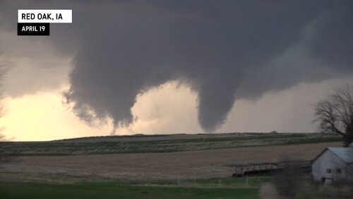
Once the core cleared I-29, traffic started moving again and we proceeded up to the Barlett exit, taking County Road J10 east toward Tabor. We were perfectly running with the storm as it really began to take shape. We continued east to north/south County Road L63, eventually working our way up to US-34 toward Red Oak. It would finally get tornado-warned.

radars.png

We hopped on IA-48 northbound out of Red Oak, stopping between there and Elliott when we did a live hit, then proceeded further north. During our haul north is when this storm finally put down. Unfortunately for us, it did so while we were moving through the worst terrain on this route, trees and hills blocked our view more times than not, but we had a view of the funnel/tornado through most of the drive. It's up for discussion as to when this made its 30-second kissing of the ground as I haven't seen anything I can match up with our timing, but alas, there it was.

Potta02.jpg

We stuck with the storm a little longer, but saw both visually and on radar that this storm was on its way to the graveyard, so we eventually parted ways and retraced our steps back to the south and west to position for the tornadic cell coming up from the Nebraska City area. By the time that storm got into intercepting range, darkness had fallen and the tornadic threat had sharply decreased. Before all went into darkness, the sunset and mammatus were a worthy stop for our last hit of the night.

fbRedOak.jpgSomewhere along IA-184 east of Tabor, we got through some rain on cells ahead of the main (now) line and were watching nearly constant CGs in just about every direction. Shortly before the junction to US-275 south of Tabor, we stopped off on a dirt road and set up for about 45 minutes of (mostly) rain-free lightning photography.

fbTabor92.jpg

I collected a couple dozen frames with good CGs, nothing I would rank as the best I've ever shot, but I won't complain. Just being able to sit in one spot for that length of time and shoot away was so nice. The challenge was pointing in the right direction as the CG activity seemed to shift from one cell to another in our south view. While I nabbed many shots, there were a lot of good ones that happened out of frame, many which you can see the illumination on the far side of the frame where the bolt hit just out of view. As the storms continued to congeal, rain began to hamper the view of most of the CG activity, so I broke down the setup and we made our way to Lincoln for the night before returning home to Colorado.

Again, Tony's Trifecta in full effect. Hail... CHECK. Tornado... CHECK. Lightning... CHECK. None of the above will get into a Top 10, but when I gauge a perfect chase, checking off all three of those boxes will do it every time. Was so nice to be on a storm we could easily keep up with, which allowed for several lengthy stops to photograph and enjoy. Our forecast in the morning gave us a prime opportunity to shift our target a bit north to account for what we considered better backing winds, and we made it in time to see the birth of this storm and enjoy all the fruits to which came with it.

It took 20 years to break my Iowa curse, that began with a rain-wrapped, but clearly obvious, tornado in northwest Iowa in August 2021. Since then, I've continued to beat away any remnant lingering effects of said curse. I think obliterate is the best word I could choose for the curse for the Ottumwa tornado a couple weeks back, and this chase, the next one in the state, seems to mean it was no fluke. In a weird way, it takes a little bit of the fun away from coming to Iowa for storm chasing as I can no longer play with the curse aspect of it. Alas, I am happy to finally see success in a state that for 20 years, always managed to get the best of me.

342648756_219558790692314_1570666611007288562_n.jpg
 

Attachments

  • RedOak02.jpg
    RedOak02.jpg
    517.8 KB · Views: 0
Final tally for the Chase County KS supercell is 8 tornadoes including 3 on the ground at once it appears. I am fairly certain we witnessed #8 but not with enough certainty to make it my first of 2023.
 
I was able to switch my day off from Thursday to Wednesday for this chase and Iowa performed again for me! Initially leading up to the chase I thought I would be heading for south central KS, but concerns over capping led me to chase the Iowa target which made it a very close chase.
I stuck around home in Omaha until 200 and then headed north up I29 initially only going about 30 miles north and stopping in Missouri Valley. The HRRR was showing 2 main areas of initiation, one north of Omaha and one south of Omaha. I was inclined to go for the north target near the warm front due to the very backed winds and forecast pooling of moisture. There was an initial attempt at initiation to my north so off I went towards Onawa. Unfortunately, motion was almost due north and never turned right and died pretty fast. When I got to Onawa, temps were down to 71 (vs 78 to my south) and it felt pretty cool and dry yet so I decided I would drift back south again.
On my way back south, sustained initiation/convection started near Fremont in eastern Nebraska. Due to the limited crossings over the Missouri R. I stayed on the Iowa side but took the nice gravel roads squished between I29 and the river to stay with the storm as it moved NNE at 30 mph.
It became very impressive visually very quickly, and was warned for tennis ball hail and 70 mph winds pretty fast. It finally turned a bit more right and crossed the river southwest of Blencoe, Iowa.
About this time cells were forming in southwest Iowa and soon one became tornado warned. My storm wasn't showing any rotation and was starting to look less impressive both in person and on radar. I had thoughts of bailing and racing south to meet those cells, but figured that would be futile so I decided to stick with this northern cell and figured I could mess around in the cell with the dime to quarter sized hail that was being reported with it.
It was shortly after this time where the cell began to take on more development on the southeast side of the cell and it turned more right moving. It was going to ride the warm front! I was driving along the south side of the cell taking on periodic hail under 1" in diameter.
It was really getting better looking on radar and I pulled into Ute. The hail was increasing in size and I remember looking back to my southwest and seeing the heavy rain/hail core coming up from the southwest into town.
I went east on Hwy 141 towards Charter Oak eventually getting out of the cell and stopping on the side of the road to view the storm. It had a broad couplet on radar and now visually it had a pretty impressive RFD cut and low wall cloud with quite a bit of rotation and motion. I decided to head back towards Ute a bit and immediately ran back into the hail, but it was now pushing quarter to golf ball sized at times so I pretty quickly turned around again thinking this was going to do something.
I continued east staying just ahead of the storm and stopping a few times to view the beast. Baseball sized hail was reported in Charter Oak a short time after I drove through and a tornado warning was finally issued. A report of a weak tornado came in as well. Visually the storm was impressive with a low wall cloud, tons of motion, a strong east wind flowing into the storm, and even better it had clear blue skies to the south to really make the structure pop.
However, it couldn't seem to drop a tornado no matter how great it looked. I made it to Dennison, Iowa and had thoughts of heading home as it was getting closer to dark. I took the highway 39 north out of town towards Deloit, IA thinking I'll give the storm about 15 more minutes. After getting just north of Deloit, I looked to my west to see a nice laminar funnel/possible tornado above the field. I immediately pulled over to start filming for a couple of minutes before heading north with the storm. After a couple of miles I stopped again as it seemed like to tornado was going to pass right in front of me on the highway.
Unfortunately, it dissipated before making it to me, but there was still very rapid motion and it had a big RFD cut that allowed me to see way up the rotating updraft. It was impressive!
I stayed with the storm for a few more minutes as it made another attempt to drop a tornado but I was soon hit with strong RFD and rain and since it was close to dark I called it a night and headed the 80 miles back home.
I'm 2 for 3 in Iowa so far this season and stupidly missed the other one on 4/4. I too have had horrible luck with Iowa in the past but the last couple of years have been pretty good.

Here's a couple links to my videos:


IMG_5731.jpegIMG_5735.jpegIMG_5737.jpegIMG_5746.jpegIMG_5753.jpeg
 
Back
Top